Manual - International Environmental Technology Centre
Manual - International Environmental Technology Centre
Manual - International Environmental Technology Centre

Create successful ePaper yourself
Turn your PDF publications into a flip-book with our unique Google optimized e-Paper software.
4.B. HOW TO ASSESS LANDSCAPE IMPACTS ON WATER QUALITY<br />
A landscape is the framework for all biogeochemical<br />
and ecological processes. Its structure defines<br />
the rate of water and chemical exchanges between<br />
land and water ecosystems in catchments and<br />
species biodiversity. All these factors determine<br />
the self-regulating potential of ecosystems and<br />
their resilience to human impacts.<br />
This chapter presents basic methods of landscape<br />
assessment using aerial photography and remotely<br />
sensed imagery in conjunction with GIS technology<br />
for estimating the rate, direction, and possible<br />
impact of landscape changes on natural resources,<br />
such as water and biodiversity.<br />
HOW ARE LANDSCAPES ASSESSED?<br />
From the point of view of protection and management<br />
of natural resources it is important to identify<br />
and quantify the following landscape<br />
structures (Table 4.4):<br />
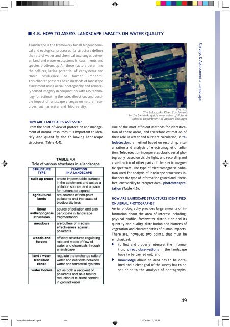
Fig. 4.2<br />
The Lubrzanka River Catchment<br />
in the Swietokrzyskie Mountains of Poland<br />
(photo: Department of Applied Ecology)<br />
One of the most efficient methods for identification<br />
of these areas, and therefore estimation of<br />
their role in water and nutrient circulation, is teledetection,<br />
a method based on recording, visualization<br />
and analysis of electromagnetic radiation.<br />
Teledetection incorporates classic aerial photography,<br />
based on visible light, and recording and<br />
visualization of other parts of the electromagnetic<br />
spectrum. The type of electromagnetic radiation<br />
used for analysis of landscape structures influences<br />
the type of information gained and, therefore,<br />
one’s ability to interpret data - photointerpretation<br />
(Table 4.5).<br />
HOW ARE LANDSCAPE STRUCTURES IDENTIFIED<br />
ON AERIAL PHOTOGRAPHS?<br />
Aerial photography provides large amounts of information<br />
about the area of interest including:<br />
physical profile, freshwater distribution and its<br />
quantity and quality, distribution and biomass of<br />
vegetation and characteristics of human impacts.<br />
There are, however, two points, that must be<br />
emphasized:<br />
to find and properly interpret the information,<br />
direct observations in the landscape<br />
have to be carried out; and<br />
knowledge about an area has to be obtained<br />
and a clear goal of the survey has to be<br />
set prior to the analysis of photographs.<br />
VwerySmatrBook03.p65 49<br />
2004-06-17, 17:24<br />
49<br />
Surveys & Assessments: Landscape