Manual - International Environmental Technology Centre
Manual - International Environmental Technology Centre
Manual - International Environmental Technology Centre

You also want an ePaper? Increase the reach of your titles
YUMPU automatically turns print PDFs into web optimized ePapers that Google loves.
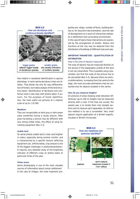
Also helpful in woodland identification is species<br />
phenology. In early spring deciduous trees are leafless.<br />
That allows not only for easy differentiation<br />
of forests, but makes analysis of the land structure<br />
easier. Identification of deciduous and coniferous<br />
trees is also easy with photos taken in autumn.<br />
For the purposes of forest identification,<br />
the most useful are pictures at a medium<br />
scale of up to 1:20 000.<br />
Meadows<br />
They are recognizable as dark-gray or dark-green<br />
areas sometimes having a cloudy texture. After<br />
grass harvesting a picture may be different with<br />
very strong visible strips, the effect of using harvesting<br />
equipment (Box 4.3).<br />
Arable land<br />
On aerial photos arable land is clear and brighter<br />
in colour, especially during summer months, and<br />
is characterized by a specific texture reflecting<br />
equipment use. Unfortunately, crop analysis is one<br />
of the biggest challenges in photointerpretation.<br />
It requires very detailed study of the brightness<br />
indicator of different crops on photos taken at<br />
particular times of the year.<br />
Urban areas<br />
Aerial photography is one of the most valuable<br />
sources of information about human settlement.<br />
In the case of villages, the most important pro-<br />
perties are: shape, number of farms, building density<br />
or, for long-term documentation, also the rate<br />
of development as a result of interactions between<br />
a settlement and surrounding environment.<br />
In the case of towns these interactions are expressed<br />
by the arrangement of streets. History and<br />
functions of the city may be deduced from the<br />
distribution of buildings of different sizes and uses.<br />
IMPORTANT PARAMETERS - QUANTIFICATION OF<br />
INFORMATION<br />
How is the area of objects measured?<br />
The area of objects may be measured directly on<br />
the picture if the topographic profile of the land<br />
is not very diversified. This is possible using a planimeter,<br />
but first the scale of the picture has to<br />
be calculated (Box 4.4). Because there are picture<br />
deformations, increasing from the centre to the<br />
edge, the most accurate estimations may be conducted<br />
only for objects situated in the centre.<br />
How do you measure lengths?<br />
On pictures of areas showing small elevation differences<br />
(up to 100 m) lengths may be measured<br />
directly with a ruler. If the lines are curved, the<br />
easiest way is to divide them into straight sections<br />
and to measure each separately. An alternative<br />
method is to use a curvometer. Very small<br />
objects require application of a Brinell magnifying<br />
glass or Brinell microscope.<br />
VwerySmatrBook03.p65 51<br />
2004-06-17, 17:24<br />
51<br />
Surveys & Assessments: Landscape