- Page 1: REPORTE FINAL DE PROYECTO ESTUARIO
- Page 4 and 5: A. Resumen Ejecutivo El resumen eje
- Page 6 and 7: RESUMEN EJECUTIVO Nombre del proyec
- Page 8 and 9: OTRAS ORGANIZACIONES ID Nombre Func
- Page 10 and 11: Información de área protegida Cat
- Page 12 and 13: PLAN DE ACCION PARA ALCANZAR A TODA
- Page 14 and 15: AMAS DE CASA PLAN DE ACCION PLAN DE
- Page 16 and 17: valor del ecosistema que los recibe
- Page 18 and 19: estuario 3) Apoyo para la validaci
- Page 20 and 21: Etapa de Acción (Práctica) RB 1)
- Page 22 and 23: 1) disponibilida d a participar en
- Page 24 and 25: 3) Migración del playero rojizo, m
- Page 26 and 27: Etapa de Validación (Comunicación
- Page 28 and 29: PLAN DE ACCIÓN PARA LLEGAR A LOS V
- Page 30 and 31: 2) Participar en el control de los
- Page 32 and 33: PLAN DE ACCIÓN PARA LLEGAR A LA MU
- Page 34 and 35: Etapa de Acción (Práctica) RB 1)
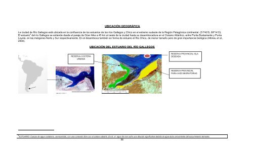
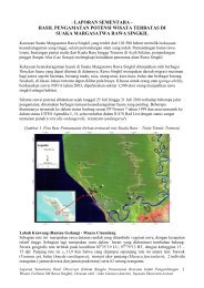
- Page 38 and 39: Tamaño La localidad de Río Galleg
- Page 40 and 41: HISTORIA DE LA CONSERVACIÓN A los
- Page 42 and 43: Provinciales -Ciencias Económicas,
- Page 44 and 45: Mediante el Decreto Nº 3478/06 reg
- Page 46 and 47: Se encuentra ubicado sobre la marge
- Page 48 and 49: Es una ONG con 2 años de funcionam
- Page 50 and 51: DESARROLLANDO UN MODELO CONCEPTUAL
- Page 53 and 54: Para entender el diagrama anterior,
- Page 55 and 56: La falta de una tenencia responsabl
- Page 57 and 58: C. Análisis de Amenaza 57
- Page 59 and 60: Basados en las definiciones de Mira
- Page 61 and 62: Cadena de Factores para MUNICIPALID
- Page 63 and 64: Cadena de Factores para VECINOS ADU
- Page 65 and 66: C. RESUMENES CREATIVOS 65
- Page 67 and 68: Acción deseada: ¿Qué queremos qu
- Page 69 and 70: E. Investigación Formativa 69
- Page 71 and 72: Indicó que en general existe en la
- Page 73 and 74: El intendente comentó con agrado l
- Page 75 and 76: Respecto de los perros resaltaron e
- Page 77 and 78: En referencia la rango de edad estu
- Page 79 and 80: 2. Preferencias de medios de Comuni
- Page 81 and 82: Grafica 9. Días a la semana que lo
- Page 83 and 84: Periódico Del total de encuestados
- Page 85 and 86: 3. Fuentes de confianza La informac
- Page 87 and 88:
A cada encuestado se les consultó
- Page 89 and 90:
6. Etapas en el Cambio de comportam
- Page 91 and 92:
Los resultados de la investigación
- Page 93 and 94:
7. Beneficios Se les pidió a los e
- Page 95 and 96:
AUDIENCIA PRIMARIA- AMAS DE CASA.
- Page 97 and 98:
Fuentes Confiables. Fuentes de medi
- Page 99 and 100:
esiduos el 38,5% mencionó que ser
- Page 101 and 102:
F. ESTRATEGIA DE CAMPAÑA 101
- Page 103 and 104:
RESUMEN EJECUTIVO Qué: Con el fin
- Page 105 and 106:
Ubicación Actual del Basural La si
- Page 107 and 108:
FASE 1: FORTALECIENDO EL APOYO DE L
- Page 109 and 110:
ACTORES CLAVE Y FUNCIONES (Fases 1
- Page 111 and 112:
SOCIOS CLAVE ASOCIACIÓN AMBIENTE S
- Page 113 and 114:
EVALUACIÓN DEL IMPACTO Si el verti
- Page 115 and 116:
FASE 2: IMPLEMENTACIÓN DEL PLAN MU
- Page 117 and 118:
EVALUACIÓN DE RIESGOS Factores de
- Page 119 and 120:
Escalera de beneficios para los vec
- Page 121 and 122:
2.1.4 Objetivos de Remoción de Bar
- Page 123 and 124:
Producto Para esta audiencia el pro
- Page 125 and 126:
ESTRATEGIA DE MENSAJE PARA AMAS DE
- Page 127 and 128:
MENSAJE CENTRAL PARA AMAS DE CASA M
- Page 129 and 130:
UMBRAL DE MENSAJES • La basura en
- Page 131 and 132:
H. Teoría de Cambio 131
- Page 133 and 134:
protección legal ambiental.(Ver pr
- Page 135 and 136:
Rio Gallegos, mediana 50% de plumaj
- Page 137 and 138:
Cadena de Resultados La vecinos est
- Page 139 and 140:
asura en la costa”. Estrategias C
- Page 141 and 142:
Actividades de Campaña: Descripci
- Page 143 and 144:
Sumando al cierre de la actividad 3
- Page 145 and 146:
EL libro contaba también con 2 esp
- Page 147 and 148:
Este último punto estuvo apuntalad
- Page 149 and 150:
Descripción de la actividad: Se tr
- Page 151 and 152:
Actividad5: Actividades al Aire Lib
- Page 153 and 154:
A continuación presentamos los cua
- Page 155 and 156:
Grupo de padres y docentes confecci
- Page 157 and 158:
*Prefectura Río Gallegos e Islas M
- Page 159 and 160:
Audiencia Meta - Población de Río
- Page 161 and 162:
Actividad 8: Diseño web Ver más I
- Page 163 and 164:
Ejemplo de 1 SPOT INTRO CANCIÓN (1
- Page 165 and 166:
Fue la presentación oficial de nue
- Page 167 and 168:
Actividad 14: Bolsas de tela para c
- Page 169 and 170:
Actividad 15: Bolsas de residuos pa
- Page 171 and 172:
Calcomanía Migrando como el player
- Page 173 and 174:
Bicicleteada a la Reserva Repercusi
- Page 175 and 176:
Se ofreció a los visitantes partic
- Page 177 and 178:
Anécdota de una ama de casa respec
- Page 179 and 180:
Distintos temas de la campaña abor
- Page 181 and 182:
Actividad 20: Capacitación a cajer
- Page 183 and 184:
Audiencia Meta -Población de Río
- Page 185 and 186:
Métodos: Pre-post encuesta La coor
- Page 187 and 188:
50 A 54 14.6% 50 A 54 9.1% 50 A 54
- Page 189 and 190:
Diseño final del afiche Comercios
- Page 191 and 192:
Impacto de la Campaña Pride en los
- Page 193 and 194:
Cuadro Cambio en Variables de Conoc
- Page 195 and 196:
Los 3 objetivos SMART, no llegaron
- Page 197 and 198:
La presentación con los concejales
- Page 199 and 200:
Este material serviría de apoyo pa
- Page 201 and 202:
Impacto de la Campaña Pride sobre
- Page 203 and 204:
SECTOR Ambiente Metodología N° de
- Page 205 and 206:
A su vez, la distribución del trab
- Page 207 and 208:
Impacto de la Campaña Pride sobre
- Page 209 and 210:
EL PRESUPUESTO Y EL CRONOGRAMA DEL
- Page 211 and 212:
FB Nº 302191 08/02/2009 PRIMAVERA
- Page 213 and 214:
FB Nº 076285 23/10/2009 EL RELOJ S
- Page 215 and 216:
FC C N°3024 01/07/2010 FM PRESENCI
- Page 217 and 218:
Revisión crítica Este capítulo d
- Page 219 and 220:
Fase de Implementación La fase de
- Page 221 and 222:
Por otro lado lo sucedido en el con
- Page 223 and 224:
Agregamos a lo comentado más arrib
- Page 225 and 226:
invalorables para la comunidad(rese
- Page 227 and 228:
M. ANEXOS 227
- Page 229 and 230:
(5) Género del encuestado LLENAR S
- Page 231 and 232:
(A) ¿Qué canales de televisión v
- Page 233 and 234:
(17) Le voy a leer una lista de enu
- Page 235 and 236:
(25) ¿Conoce alguna ley que regule
- Page 237 and 238:
(C) Respetar siempre los horarios e
- Page 239 and 240:
(A) Si se manejan bien los residuos
- Page 241 and 242:
ANEXO II NOTA SOLICITUD FINAN CIAMI