Tous les prix en Francs Suisses - Harteveld Rare Books Ltd.
Tous les prix en Francs Suisses - Harteveld Rare Books Ltd.
Tous les prix en Francs Suisses - Harteveld Rare Books Ltd.

You also want an ePaper? Increase the reach of your titles
YUMPU automatically turns print PDFs into web optimized ePapers that Google loves.
6 <strong>Harteveld</strong> <strong>Rare</strong> <strong>Books</strong> <strong>Ltd</strong>., CH-1700 Fribourg<br />
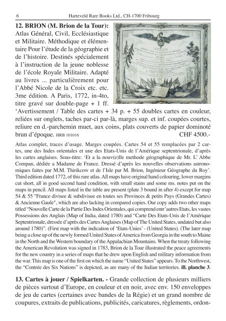
12. BRION (M. Brion de la Tour):<br />
Atlas Général, Civil, Ecclésiastique<br />
et Militaire. Méthodique et élém<strong>en</strong>taire<br />
Pour l’étude de la géographie et<br />
de l’histoire. Destinés spécialem<strong>en</strong>t<br />
à l’instruction de la jeune nob<strong>les</strong>se<br />
de l’école Royale Militaire. Adapté<br />
au livres ... particulièrem<strong>en</strong>t pour<br />
l’Abbé Nicole de la Croix etc. etc.<br />
3me édition. A Paris, 1772, in-4to,<br />
titre gravé sur double-page + 1 ff.<br />
‘Avertissem<strong>en</strong>t / Table des cartes + 34 p. + 55 doub<strong>les</strong> cartes <strong>en</strong> couleur,<br />
reliées sur onglets, taches par-ci par-là, marges sup. et inf. coupées courtes,<br />
reliure <strong>en</strong> d.-parchemin muet, aux coins, plats couverts de papier dominoté<br />
brun d’époque. HRB 101016 CHF 4500.-<br />
Atlas complet, traces d’usage. Marges coupées. Cartes 54 et 55 remplacées par 2 cartes,<br />
une des Indes ori<strong>en</strong>ta<strong>les</strong> et une des Etats-Unis de l’Amérique sept<strong>en</strong>trionale, d’après<br />
<strong>les</strong> cartes anglaises. Sous-titre: ‘Et a la nouv(e)lle methode géographique de Mr. L’ Abbe<br />
Compan, dédiée a Madame de France. Dressé d’après <strong>les</strong> nouvel<strong>les</strong> observations astronomiques<br />
faites par M.M. Thirikcow et de l’Isle par M. Brion, Ingénieur Géographe du Roy’.<br />
Third edition dated 1772, of this rare atlas. All maps have original hand colouring, lower margins<br />
cut short, all in good second hand condition, with small stains and some ms. notes put on the<br />
maps in p<strong>en</strong>cil. All maps listed in the table are pres<strong>en</strong>t (plate 3 bound in after 4) except for map<br />
54 & 55 "France divisee & subdivisee <strong>en</strong> toutes ses Provinces & petits Pays (Grandes Cartes)<br />
& Anci<strong>en</strong>ne Gaule", which are also lacking in compared copies. Our copy adds two other maps<br />
titled “Nouvelle Carte de la Partie Des Indes Ori<strong>en</strong>ta<strong>les</strong>, qui compr<strong>en</strong>d <strong>en</strong>tr’autres Etats, <strong>les</strong> vastes<br />
Possessions des Anglais (Map of India, dated 1780) and “Carte Des Etats-Unis de l’Amérique<br />
Sept<strong>en</strong>trionale, dressée d’après des Cartes Anglaises (Map of The United States, undated but also<br />
around 1780)”. (First map with the indication of ‘Etats-Unies’ - (United States). (The later map<br />
being a close up of the newly formed United States of America from Georgia in the south to Maine<br />
in the North and the Western boundary of the Appalachian Mountains. Wh<strong>en</strong> the treaty following<br />
the American Revolution was signed in 1783, Brion de la Tour illustrated the peace agreem<strong>en</strong>ts<br />
for the new country in a series of maps that he drew upon English and military information from<br />
the war. This map is one of the first on which the name “United States” appears. To the Northwest,<br />
the “Contrée des Six Nations” is depicted, as are many of the Indian territories. ill. planche 3.<br />
13. Cartes à jouer / Spielkart<strong>en</strong>. - Grande collection de plusieurs milliers<br />
de pièces surtout d’Europe, <strong>en</strong> couleur et <strong>en</strong> noir, avec <strong>en</strong>v. 150 <strong>en</strong>veloppes<br />
de jeu de cartes (certaines avec bandes de la Régie) et un grand nombre de<br />
coupures, extraits de publications, publicités, caricatures, règlem<strong>en</strong>ts, ordon-