- Page 1: Rivista italiana di studi americani
- Page 4 and 5: THULE Rivista italiana di studi ame
- Page 6 and 7: THULE Rivista italiana di studi ame
- Page 8 and 9: 187 Stefano Aviani Barbacci - Chiar
- Page 10 and 11: Quinta parte Gli Indigeni e il terr
- Page 12: 951 Esther Acevedo Entre anticuario
- Page 16: Prima parte La cultura e i suoi sim
- Page 19 and 20: 18 Valeria Bellomia instrumentos mu
- Page 21 and 22: 20 Valeria Bellomia El espécimen M
- Page 23 and 24: 22 Valeria Bellomia En los Primeros
- Page 25 and 26: 24 Valeria Bellomia Un chicāhuaztl
- Page 27 and 28: 26 Valeria Bellomia En el caso de l
- Page 29 and 30: 28 Valeria Bellomia Podemos postula
- Page 31 and 32: 30 Valeria Bellomia los resultados
- Page 33 and 34: 32 Valeria Bellomia (2) Los términ
- Page 35 and 36: 34 Valeria Bellomia BIERHORST John,
- Page 37 and 38: 36 Valeria Bellomia NOBILI Carlo, [
- Page 39 and 40: 38 Davide Domenici, Imma Valese Val
- Page 41 and 42: 40 Davide Domenici, Imma Valese fut
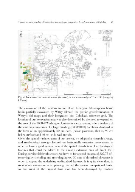
- Page 43: 42 Davide Domenici, Imma Valese Fig
- Page 47 and 48: 46 Davide Domenici, Imma Valese rot
- Page 49 and 50: 48 Davide Domenici, Imma Valese Fig
- Page 51 and 52: 50 Davide Domenici, Imma Valese H12
- Page 53 and 54: 52 Davide Domenici, Imma Valese as
- Page 55 and 56: 54 Davide Domenici, Imma Valese rep
- Page 57 and 58: 56 Davide Domenici, Imma Valese and
- Page 59 and 60: 58 Davide Domenici, Imma Valese bre
- Page 61 and 62: 60 Davide Domenici, Imma Valese res
- Page 63 and 64: 62 Davide Domenici, Imma Valese Mis
- Page 65 and 66: 64 Davide Domenici, Imma Valese KEL
- Page 68 and 69: 67 THULE Riv. Ital. studi americani
- Page 70 and 71: Un pionero de la Arqueología mexic
- Page 72 and 73: Un pionero de la Arqueología mexic
- Page 74 and 75: Un pionero de la Arqueología mexic
- Page 76 and 77: Un pionero de la Arqueología mexic
- Page 78 and 79: Un pionero de la Arqueología mexic
- Page 80 and 81: Un pionero de la Arqueología mexic
- Page 82 and 83: Un pionero de la Arqueología mexic
- Page 84 and 85: Un pionero de la Arqueología mexic
- Page 86 and 87: Un pionero de la Arqueología mexic
- Page 88 and 89: Un pionero de la Arqueología mexic
- Page 90 and 91: 89 THULE Riv. Ital. studi americani
- Page 92 and 93: Investigation of the palimpsest of
- Page 94 and 95:
Investigation of the palimpsest of
- Page 96 and 97:
Investigation of the palimpsest of
- Page 98 and 99:
Investigation of the palimpsest of
- Page 100 and 101:
Investigation of the palimpsest of
- Page 102 and 103:
Investigation of the palimpsest of
- Page 104:
Investigation of the palimpsest of
- Page 107 and 108:
106 Angélica Delgado Salgado la zo
- Page 109 and 110:
108 Angélica Delgado Salgado M. Ga
- Page 111 and 112:
110 Angélica Delgado Salgado edifi
- Page 113 and 114:
112 Angélica Delgado Salgado Chanc
- Page 115 and 116:
114 Angélica Delgado Salgado Nacio
- Page 117 and 118:
116 Angélica Delgado Salgado En el
- Page 119 and 120:
118 Angélica Delgado Salgado Ucú
- Page 121 and 122:
120 Angélica Delgado Salgado Teabo
- Page 123 and 124:
122 Angélica Delgado Salgado Balan
- Page 125 and 126:
124 Angélica Delgado Salgado Salto
- Page 127 and 128:
126 Angélica Delgado Salgado Piña
- Page 130 and 131:
129 THULE Riv. Ital. studi american
- Page 132 and 133:
Estudio del contenido botánico de
- Page 134 and 135:
Estudio del contenido botánico de
- Page 136 and 137:
Estudio del contenido botánico de
- Page 138 and 139:
Estudio del contenido botánico de
- Page 140 and 141:
Estudio del contenido botánico de
- Page 142 and 143:
Estudio del contenido botánico de
- Page 144:
Seconda parte Percorsi dell’ident
- Page 147 and 148:
146 Tristano Volpato Además, debid
- Page 149 and 150:
148 Tristano Volpato y poco afín c
- Page 151 and 152:
150 Tristano Volpato Veracruz, y Xa
- Page 153 and 154:
152 Tristano Volpato específica de
- Page 155 and 156:
154 Tristano Volpato Solamente con
- Page 157 and 158:
156 Tristano Volpato Italianos de C
- Page 159 and 160:
158 Tristano Volpato Finalmente, un
- Page 161 and 162:
160 Tristano Volpato Idioma El idio
- Page 163 and 164:
162 Tristano Volpato indígenas de
- Page 165 and 166:
164 Tristano Volpato En el primer c
- Page 167 and 168:
166 Tristano Volpato afuera de las
- Page 169 and 170:
168 Tristano Volpato MONTAGNER ANGU
- Page 172 and 173:
THULE Riv. Ital. studi americanisti
- Page 174 and 175:
Literatura indígena: em uma perspe
- Page 176 and 177:
Literatura indígena: em uma perspe
- Page 178 and 179:
Literatura indígena: em uma perspe
- Page 180 and 181:
Literatura indígena: em uma perspe
- Page 182 and 183:
Literatura indígena: em uma perspe
- Page 184 and 185:
Literatura indígena: em uma perspe
- Page 186 and 187:
Literatura indígena: em uma perspe
- Page 188 and 189:
165 THULE Riv. Ital. studi american
- Page 190 and 191:
La Rosa nascosta ne El Aleph de J.
- Page 192 and 193:
La Rosa nascosta ne El Aleph de J.
- Page 194 and 195:
La Rosa nascosta ne El Aleph de J.
- Page 196 and 197:
La Rosa nascosta ne El Aleph de J.
- Page 198 and 199:
La Rosa nascosta ne El Aleph de J.
- Page 200 and 201:
La Rosa nascosta ne El Aleph de J.
- Page 202 and 203:
La Rosa nascosta ne El Aleph de J.
- Page 204:
La Rosa nascosta ne El Aleph de J.
- Page 207 and 208:
206 Yasmina Yousfi López No nos de
- Page 209 and 210:
208 Yasmina Yousfi López 398). Al
- Page 211 and 212:
210 Yasmina Yousfi López agente de
- Page 213 and 214:
212 Yasmina Yousfi López extermini
- Page 215 and 216:
214 Yasmina Yousfi López Arminda h
- Page 217 and 218:
216 Yasmina Yousfi López textos en
- Page 219 and 220:
218 Yasmina Yousfi López Bibliogra
- Page 222 and 223:
221 THULE Riv. Ital. studi american
- Page 224 and 225:
Relatos orales de inmigración ital
- Page 226 and 227:
Relatos orales de inmigración ital
- Page 228 and 229:
Relatos orales de inmigración ital
- Page 230 and 231:
Relatos orales de inmigración ital
- Page 232 and 233:
Relatos orales de inmigración ital
- Page 234 and 235:
Relatos orales de inmigración ital
- Page 236 and 237:
Relatos orales de inmigración ital
- Page 238 and 239:
Relatos orales de inmigración ital
- Page 240 and 241:
Relatos orales de inmigración ital
- Page 242 and 243:
Relatos orales de inmigración ital
- Page 244 and 245:
Relatos orales de inmigración ital
- Page 246 and 247:
245 THULE Riv. Ital. studi american
- Page 248 and 249:
Who is the Other? Cultures of trans
- Page 250 and 251:
Who is the Other? Cultures of trans
- Page 252 and 253:
Who is the Other? Cultures of trans
- Page 254 and 255:
Who is the Other? Cultures of trans
- Page 256 and 257:
Who is the Other? Cultures of trans
- Page 258 and 259:
Who is the Other? Cultures of trans
- Page 260 and 261:
Who is the Other? Cultures of trans
- Page 262 and 263:
Who is the Other? Cultures of trans
- Page 264 and 265:
Who is the Other? Cultures of trans
- Page 266 and 267:
265 Who is the Other? Cultures of t
- Page 268 and 269:
Who is the Other? Cultures of trans
- Page 270 and 271:
Who is the Other? Cultures of trans
- Page 272 and 273:
Who is the Other? Cultures of trans
- Page 274 and 275:
Who is the Other? Cultures of trans
- Page 276 and 277:
Who is the Other? Cultures of trans
- Page 278 and 279:
Who is the Other? Cultures of trans
- Page 280 and 281:
Who is the Other? Cultures of trans
- Page 282 and 283:
Who is the Other? Cultures of trans
- Page 284:
Terza parte Le arti: sintesi ed esp
- Page 287 and 288:
286 Román Robles Mendoza, Raquel J
- Page 289 and 290:
288 Román Robles Mendoza, Raquel J
- Page 291 and 292:
290 Román Robles Mendoza, Raquel J
- Page 293 and 294:
292 Román Robles Mendoza, Raquel J
- Page 295 and 296:
294 Román Robles Mendoza, Raquel J
- Page 297 and 298:
296 Román Robles Mendoza, Raquel J
- Page 299 and 300:
298 Román Robles Mendoza, Raquel J
- Page 301 and 302:
300 Román Robles Mendoza, Raquel J
- Page 303 and 304:
302 Román Robles Mendoza, Raquel J
- Page 305 and 306:
304 Román Robles Mendoza, Raquel J
- Page 307 and 308:
306 Román Robles Mendoza, Raquel J
- Page 309 and 310:
308 Marco Velázquez Albo La histor
- Page 311 and 312:
310 Marco Velázquez Albo En este s
- Page 313 and 314:
312 Marco Velázquez Albo 1937 y ha
- Page 315 and 316:
314 Marco Velázquez Albo 1920 hast
- Page 317 and 318:
316 Marco Velázquez Albo músicos
- Page 319 and 320:
318 Marco Velázquez Albo presentac
- Page 321 and 322:
320 Marco Velázquez Albo CENTRO DE
- Page 324 and 325:
323 THULE Riv. Ital. studi american
- Page 326 and 327:
Transculturación y apropiación cu
- Page 328 and 329:
Transculturación y apropiación cu
- Page 330 and 331:
Transculturación y apropiación cu
- Page 332 and 333:
Transculturación y apropiación cu
- Page 334 and 335:
Transculturación y apropiación cu
- Page 336 and 337:
Transculturación y apropiación cu
- Page 338 and 339:
Transculturación y apropiación cu
- Page 340 and 341:
Transculturación y apropiación cu
- Page 342 and 343:
Transculturación y apropiación cu
- Page 344 and 345:
Transculturación y apropiación cu
- Page 346 and 347:
Transculturación y apropiación cu
- Page 348 and 349:
Transculturación y apropiación cu
- Page 350 and 351:
Transculturación y apropiación cu
- Page 352 and 353:
351 THULE Riv. Ital. studi american
- Page 354 and 355:
El Carnaval en la localidad de Tilc
- Page 356 and 357:
El Carnaval en la localidad de Tilc
- Page 358 and 359:
El Carnaval en la localidad de Tilc
- Page 360 and 361:
359 THULE Riv. Ital. studi american
- Page 362 and 363:
Lo indígena en las artes de las re
- Page 364 and 365:
Lo indígena en las artes de las re
- Page 366 and 367:
Lo indígena en las artes de las re
- Page 368 and 369:
Lo indígena en las artes de las re
- Page 370 and 371:
Lo indígena en las artes de las re
- Page 372 and 373:
Lo indígena en las artes de las re
- Page 374 and 375:
Lo indígena en las artes de las re
- Page 376 and 377:
THULE Riv. Ital. studi americanisti
- Page 378 and 379:
377 O Teatro de Mamulengo na metró
- Page 380 and 381:
379 O Teatro de Mamulengo na metró
- Page 382 and 383:
381 O Teatro de Mamulengo na metró
- Page 384 and 385:
383 THULE Riv. Ital. studi american
- Page 386 and 387:
Il misero paesaggio di una fortezza
- Page 388 and 389:
Il misero paesaggio di una fortezza
- Page 390 and 391:
Il misero paesaggio di una fortezza
- Page 392 and 393:
Il misero paesaggio di una fortezza
- Page 394 and 395:
Il misero paesaggio di una fortezza
- Page 396 and 397:
Il misero paesaggio di una fortezza
- Page 398 and 399:
Il misero paesaggio di una fortezza
- Page 400 and 401:
Il misero paesaggio di una fortezza
- Page 402 and 403:
Il misero paesaggio di una fortezza
- Page 404 and 405:
Il misero paesaggio di una fortezza
- Page 406 and 407:
Il misero paesaggio di una fortezza
- Page 408:
Il misero paesaggio di una fortezza
- Page 412 and 413:
411 THULE Riv. Ital. studi american
- Page 414 and 415:
« La Tierra nuestra madre ». Cosm
- Page 416 and 417:
« La Tierra nuestra madre ». Cosm
- Page 418 and 419:
« La Tierra nuestra madre ». Cosm
- Page 420 and 421:
« La Tierra nuestra madre ». Cosm
- Page 422 and 423:
« La Tierra nuestra madre ». Cosm
- Page 424 and 425:
« La Tierra nuestra madre ». Cosm
- Page 426 and 427:
« La Tierra nuestra madre ». Cosm
- Page 428 and 429:
427 THULE Riv. Ital. studi american
- Page 430 and 431:
Ondeggiando con le maracá 429 prop
- Page 432 and 433:
Ondeggiando con le maracá 431 ngô
- Page 434 and 435:
Ondeggiando con le maracá 433 sare
- Page 436 and 437:
Ondeggiando con le maracá 435 dett
- Page 438:
Ondeggiando con le maracá 437 LATO
- Page 441 and 442:
440 Edmundo Antonio Peggion da regi
- Page 443 and 444:
442 Edmundo Antonio Peggion (entre
- Page 445 and 446:
444 Edmundo Antonio Peggion de povo
- Page 447 and 448:
446 Edmundo Antonio Peggion verba p
- Page 449 and 450:
448 Edmundo Antonio Peggion PEGGION
- Page 451 and 452:
450 Joelma Monteiro de Carvalho, Si
- Page 453 and 454:
452 Joelma Monteiro de Carvalho, Si
- Page 455 and 456:
454 Joelma Monteiro de Carvalho, Si
- Page 457 and 458:
456 Joelma Monteiro de Carvalho, Si
- Page 459 and 460:
458 Joelma Monteiro de Carvalho, Si
- Page 461 and 462:
460 Joelma Monteiro de Carvalho, Si
- Page 463 and 464:
462 Joelma Monteiro de Carvalho, Si
- Page 465 and 466:
464 Joelma Monteiro de Carvalho, Si
- Page 467 and 468:
466 Joelma Monteiro de Carvalho, Si
- Page 469 and 470:
468 Joelma Monteiro de Carvalho, Si
- Page 471 and 472:
470 Joelma Monteiro de Carvalho, Si
- Page 473 and 474:
472 Joelma Monteiro de Carvalho, Si
- Page 475 and 476:
474 Joelma Monteiro de Carvalho, Si
- Page 478 and 479:
477 THULE Riv. Ital. studi american
- Page 480 and 481:
La expresión del lenguaje ritual m
- Page 482 and 483:
La expresión del lenguaje ritual m
- Page 484 and 485:
La expresión del lenguaje ritual m
- Page 486 and 487:
La expresión del lenguaje ritual m
- Page 488 and 489:
La expresión del lenguaje ritual m
- Page 490 and 491:
La expresión del lenguaje ritual m
- Page 492 and 493:
491 THULE Riv. Ital. studi american
- Page 494 and 495:
El territorio devocional del Cristo
- Page 496 and 497:
El territorio devocional del Cristo
- Page 498 and 499:
El territorio devocional del Cristo
- Page 500 and 501:
El territorio devocional del Cristo
- Page 502 and 503:
El territorio devocional del Cristo
- Page 504 and 505:
El territorio devocional del Cristo
- Page 506 and 507:
El territorio devocional del Cristo
- Page 508 and 509:
El territorio devocional del Cristo
- Page 510 and 511:
El territorio devocional del Cristo
- Page 512 and 513:
El territorio devocional del Cristo
- Page 514 and 515:
El territorio devocional del Cristo
- Page 516:
El territorio devocional del Cristo
- Page 519 and 520:
518 María Guadalupe Díaz Tepepa l
- Page 521 and 522:
520 María Guadalupe Díaz Tepepa p
- Page 523 and 524:
522 María Guadalupe Díaz Tepepa L
- Page 525 and 526:
524 María Guadalupe Díaz Tepepa t
- Page 527 and 528:
526 María Guadalupe Díaz Tepepa S
- Page 529 and 530:
528 María Guadalupe Díaz Tepepa i
- Page 531 and 532:
530 María Guadalupe Díaz Tepepa C
- Page 533 and 534:
532 María Guadalupe Díaz Tepepa T
- Page 535 and 536:
534 Mario Ortega Olivares VALENZUEL
- Page 537 and 538:
536 Mario Ortega Olivares Melitón
- Page 539 and 540:
538 Mario Ortega Olivares Problema
- Page 541 and 542:
540 Mario Ortega Olivares permitió
- Page 543 and 544:
542 Mario Ortega Olivares Charras d
- Page 545 and 546:
544 Mario Ortega Olivares familiare
- Page 547 and 548:
546 Mario Ortega Olivares conseguir
- Page 549 and 550:
548 Mario Ortega Olivares El compad
- Page 551 and 552:
550 Mario Ortega Olivares Fig. 3 Di
- Page 553 and 554:
552 Mario Ortega Olivares conseguid
- Page 555 and 556:
554 Mario Ortega Olivares CASTAÑO
- Page 557 and 558:
556 Mario Ortega Olivares VALDES Fi
- Page 559 and 560:
558 Anna Sulai Capponi Pero Guayana
- Page 561 and 562:
560 Anna Sulai Capponi informacione
- Page 563 and 564:
562 Anna Sulai Capponi De la preocu
- Page 565 and 566:
564 Anna Sulai Capponi A la fiesta,
- Page 567 and 568:
566 Anna Sulai Capponi que admite l
- Page 569 and 570:
568 Anna Sulai Capponi Estos últim
- Page 571 and 572:
570 Anna Sulai Capponi LISCANO Juan
- Page 574 and 575:
573 THULE Riv. Ital. studi american
- Page 576 and 577:
Cosmologia e Territorialidade: huma
- Page 578 and 579:
Cosmologia e Territorialidade: huma
- Page 580 and 581:
Cosmologia e Territorialidade: huma
- Page 582 and 583:
Cosmologia e Territorialidade: huma
- Page 584 and 585:
Cosmologia e Territorialidade: huma
- Page 586 and 587:
Cosmologia e Territorialidade: huma
- Page 588 and 589:
Cosmologia e Territorialidade: huma
- Page 590 and 591:
Cosmologia e Territorialidade: huma
- Page 592 and 593:
Cosmologia e Territorialidade: huma
- Page 594 and 595:
Cosmologia e Territorialidade: huma
- Page 596:
Cosmologia e Territorialidade: huma
- Page 599 and 600:
598 Daniele Fini Sistema Comunitari
- Page 601 and 602:
600 Daniele Fini siano) per conside
- Page 603 and 604:
602 Daniele Fini Il territorio seco
- Page 605 and 606:
604 Daniele Fini «Attraverso il bo
- Page 607 and 608:
606 Daniele Fini rappresenta una co
- Page 609 and 610:
608 Daniele Fini costituzione sia d
- Page 611 and 612:
610 Daniele Fini COMMISSIONE RODOT
- Page 614 and 615:
613 THULE Riv. Ital. studi american
- Page 616 and 617:
Nova Cartografia Social: experiênc
- Page 618 and 619:
Nova Cartografia Social: experiênc
- Page 620 and 621:
Nova Cartografia Social: experiênc
- Page 622 and 623:
Nova Cartografia Social: experiênc
- Page 624 and 625:
Nova Cartografia Social: experiênc
- Page 626 and 627:
Nova Cartografia Social: experiênc
- Page 628 and 629:
Nova Cartografia Social: experiênc
- Page 630 and 631:
Nova Cartografia Social: experiênc
- Page 632 and 633:
Nova Cartografia Social: experiênc
- Page 634:
Nova Cartografia Social: experiênc
- Page 637 and 638:
636 Rocío Noemí M. Martínez Gonz
- Page 639 and 640:
638 Rocío Noemí M. Martínez Gonz
- Page 641 and 642:
640 Rocío Noemí M. Martínez Gonz
- Page 643 and 644:
642 Rocío Noemí M. Martínez Gonz
- Page 645 and 646:
644 Rocío Noemí M. Martínez Gonz
- Page 647 and 648:
646 Rocío Noemí M. Martínez Gonz
- Page 649 and 650:
648 Rocío Noemí M. Martínez Gonz
- Page 651 and 652:
650 Rocío Noemí M. Martínez Gonz
- Page 653 and 654:
652 Rocío Noemí M. Martínez Gonz
- Page 655 and 656:
654 Rocío Noemí M. Martínez Gonz
- Page 657 and 658:
656 Rocío Noemí M. Martínez Gonz
- Page 659 and 660:
658 Rocío Noemí M. Martínez Gonz
- Page 661 and 662:
660 Rocío Noemí M. Martínez Gonz
- Page 663 and 664:
662 Rocío Noemí M. Martínez Gonz
- Page 665 and 666:
664 Gaia Carosi stati rappresentati
- Page 667 and 668:
666 Gaia Carosi disposti su strati
- Page 669 and 670:
668 Gaia Carosi mentre nel Quintana
- Page 671 and 672:
670 Gaia Carosi un’alternanza di
- Page 673 and 674:
672 Gaia Carosi livelli di fluttuaz
- Page 675 and 676:
674 Gaia Carosi Progreso, con solo
- Page 677 and 678:
676 Gaia Carosi costante ricambio c
- Page 679 and 680:
678 Gaia Carosi La disposizione dei
- Page 681 and 682:
680 Gaia Carosi Landa scriveva: «l
- Page 683 and 684:
682 Gaia Carosi colore marrone-ross
- Page 685 and 686:
684 Gaia Carosi Note (1) Primi tra
- Page 687 and 688:
686 Gaia Carosi DUNNINGS Nicholas P
- Page 689 and 690:
688 Gaia Carosi DUCH G. 1991: 168-1
- Page 691 and 692:
690 Omar Aguilar Sánchez Fig. 1. L
- Page 693 and 694:
692 Omar Aguilar Sánchez Los Códi
- Page 695 and 696:
694 Omar Aguilar Sánchez de todo l
- Page 697 and 698:
696 Omar Aguilar Sánchez aquella p
- Page 699 and 700:
698 Omar Aguilar Sánchez en el lit
- Page 701 and 702:
700 Omar Aguilar Sánchez cada Rep
- Page 703 and 704:
702 Omar Aguilar Sánchez Reflexion
- Page 705 and 706:
704 Omar Aguilar Sánchez de discri
- Page 707 and 708:
706 Omar Aguilar Sánchez JANSEN Ma
- Page 710 and 711:
709 THULE Riv. Ital. studi american
- Page 712 and 713:
El imaginario territorial Wixárika
- Page 714 and 715:
El imaginario territorial Wixárika
- Page 716 and 717:
El imaginario territorial Wixárika
- Page 718 and 719:
El imaginario territorial Wixárika
- Page 720 and 721:
El imaginario territorial Wixárika
- Page 722 and 723:
El imaginario territorial Wixárika
- Page 724 and 725:
El imaginario territorial Wixárika
- Page 726 and 727:
El imaginario territorial Wixárika
- Page 728:
Sesta parte Istituzioni, diritti, g
- Page 731 and 732:
730 M. E. Pérez García, I. Escalo
- Page 733 and 734:
732 M. E. Pérez García, I. Escalo
- Page 735 and 736:
734 M. E. Pérez García, I. Escalo
- Page 737 and 738:
736 M. E. Pérez García, I. Escalo
- Page 739 and 740:
738 M. E. Pérez García, I. Escalo
- Page 741 and 742:
740 M. E. Pérez García, I. Escalo
- Page 743 and 744:
742 M. E. Pérez García, I. Escalo
- Page 745 and 746:
744 M. E. Pérez García, I. Escalo
- Page 747 and 748:
746 M. E. Pérez García, I. Escalo
- Page 749 and 750:
748 M. E. Pérez García, I. Escalo
- Page 751 and 752:
750 M. E. Pérez García, I. Escalo
- Page 753 and 754:
752 M. E. Pérez García, I. Escalo
- Page 755 and 756:
754 M. E. Pérez García, I. Escalo
- Page 757 and 758:
756 M. E. Pérez García, I. Escalo
- Page 759 and 760:
758 Paola Ma. Sesia Las violaciones
- Page 761 and 762:
760 Paola Ma. Sesia derechos a la a
- Page 763 and 764:
762 Paola Ma. Sesia Antes de pasar
- Page 765 and 766:
764 Paola Ma. Sesia personal médic
- Page 767 and 768:
766 Paola Ma. Sesia no hablaba el e
- Page 769 and 770:
768 Paola Ma. Sesia parecer, es una
- Page 771 and 772:
770 Paola Ma. Sesia en sus informes
- Page 773 and 774:
772 Paola Ma. Sesia Además y tal v
- Page 775 and 776:
774 Paola Ma. Sesia (6) En Oaxaca,
- Page 777 and 778:
776 Paola Ma. Sesia ENCUESTA NACION
- Page 780 and 781:
THULE Riv. Ital. studi americanisti
- Page 782 and 783:
Cruzando fronteras y abriendo puert
- Page 784 and 785:
Cruzando fronteras y abriendo puert
- Page 786 and 787:
Cruzando fronteras y abriendo puert
- Page 788 and 789:
Cruzando fronteras y abriendo puert
- Page 790 and 791:
Cruzando fronteras y abriendo puert
- Page 792 and 793:
Cruzando fronteras y abriendo puert
- Page 794 and 795:
Cruzando fronteras y abriendo puert
- Page 796 and 797:
Cruzando fronteras y abriendo puert
- Page 798 and 799:
Cruzando fronteras y abriendo puert
- Page 800:
Cruzando fronteras y abriendo puert
- Page 803 and 804:
802 Aurora Loyo Brambila Meneses co
- Page 805 and 806:
804 Aurora Loyo Brambila abiertas a
- Page 807 and 808:
806 Aurora Loyo Brambila salud, con
- Page 809 and 810:
808 Aurora Loyo Brambila En 1982 en
- Page 811 and 812:
810 Aurora Loyo Brambila La alianza
- Page 813 and 814:
812 Aurora Loyo Brambila presupuest
- Page 816:
Settima parte Nuovi americani e le
- Page 819 and 820:
818 Sergio Hernández Galindo Sin e
- Page 821 and 822:
820 Sergio Hernández Galindo econo
- Page 823 and 824:
822 Sergio Hernández Galindo Migra
- Page 825 and 826:
824 Sergio Hernández Galindo que p
- Page 827 and 828:
826 Sergio Hernández Galindo Foto
- Page 829 and 830:
828 Sergio Hernández Galindo Yamaz
- Page 831 and 832:
830 Sergio Hernández Galindo utili
- Page 833 and 834:
832 Sergio Hernández Galindo escue
- Page 835 and 836:
834 Sergio Hernández Galindo “re
- Page 837 and 838:
836 Sergio Hernández Galindo Braud
- Page 839 and 840:
838 Cristina Pizzonia En este traba
- Page 841 and 842:
840 Cristina Pizzonia que espera ob
- Page 843 and 844:
842 Cristina Pizzonia de los Estado
- Page 845 and 846:
844 Cristina Pizzonia internacional
- Page 847 and 848:
846 Cristina Pizzonia En el siglo X
- Page 849 and 850:
848 Cristina Pizzonia 1970 - 1990 C
- Page 851 and 852:
850 Cristina Pizzonia importante. M
- Page 853 and 854:
852 Cristina Pizzonia altos niveles
- Page 855 and 856:
854 Cristina Pizzonia Política mig
- Page 857 and 858:
856 Cristina Pizzonia En el año 20
- Page 859 and 860:
858 Cristina Pizzonia De acuerdo co
- Page 861 and 862:
860 Cristina Pizzonia DIDOU AUPETIT
- Page 863 and 864:
862 Cristina Pizzonia Internazional
- Page 865 and 866:
864 Daniela Salvucci Memorie famili
- Page 867 and 868:
866 Daniela Salvucci La memoria gen
- Page 869 and 870:
868 Daniela Salvucci la cittadinanz
- Page 871 and 872:
870 Daniela Salvucci invece aspira
- Page 873 and 874:
872 Daniela Salvucci Nel 1987, per
- Page 875 and 876:
874 Daniela Salvucci La genealogia,
- Page 877 and 878:
876 Daniela Salvucci nell’intervi
- Page 879 and 880:
878 Daniela Salvucci parenti”, o
- Page 881 and 882:
880 Daniela Salvucci inferiore, sop
- Page 883 and 884:
882 Daniela Salvucci dei pregiudizi
- Page 885 and 886:
884 Daniela Salvucci GRILLI Simonet
- Page 887 and 888:
886 Mara Donat de la pampa húmeda,
- Page 889 and 890:
888 Mara Donat Naturalmente la obra
- Page 891 and 892:
890 Mara Donat El árbol genealógi
- Page 893 and 894:
892 Mara Donat hecho, no encontramo
- Page 895 and 896:
894 Mara Donat exilio viven en la d
- Page 897 and 898:
896 Mara Donat memoria, preservada
- Page 899 and 900:
898 Mara Donat con todo no se emanc
- Page 901 and 902:
900 Mara Donat novela que analizamo
- Page 903 and 904:
902 Mara Donat descendencias en la
- Page 905 and 906:
904 Mara Donat exilio, en la plural
- Page 907 and 908:
906 Mara Donat titula “Este es el
- Page 909 and 910:
908 Mara Donat Notas (1) Véase los
- Page 911 and 912:
910 Mara Donat PEÑA María Dolores
- Page 914 and 915:
913 THULE Riv. Ital. studi american
- Page 916 and 917:
Konrad Theodor Preuss y el Mito de
- Page 918 and 919:
Konrad Theodor Preuss y el Mito de
- Page 920 and 921:
Konrad Theodor Preuss y el Mito de
- Page 922 and 923:
Konrad Theodor Preuss y el Mito de
- Page 924 and 925:
Konrad Theodor Preuss y el Mito de
- Page 926 and 927:
925 THULE Riv. Ital. studi american
- Page 928 and 929:
El imaginario de la lucha de la civ
- Page 930 and 931:
El imaginario de la lucha de la civ
- Page 932 and 933:
El imaginario de la lucha de la civ
- Page 934 and 935:
El imaginario de la lucha de la civ
- Page 936 and 937:
El imaginario de la lucha de la civ
- Page 938 and 939:
El imaginario de la lucha de la civ
- Page 940 and 941:
El imaginario de la lucha de la civ
- Page 942 and 943:
El imaginario de la lucha de la civ
- Page 944 and 945:
El imaginario de la lucha de la civ
- Page 946 and 947:
El imaginario de la lucha de la civ
- Page 948 and 949:
El imaginario de la lucha de la civ
- Page 950:
El imaginario de la lucha de la civ
- Page 953 and 954:
952 Esther Acevedo Encontrar el ori
- Page 955 and 956:
954 Esther Acevedo importantes prov
- Page 957 and 958:
956 Esther Acevedo los museos nacio
- Page 959 and 960:
958 Esther Acevedo existiendo 30 sa
- Page 962 and 963:
961 THULE Riv. Ital. studi american
- Page 964 and 965:
Gisèle Freund y su traiectoria lat
- Page 966 and 967:
Gisèle Freund y su traiectoria lat
- Page 968 and 969:
Gisèle Freund y su traiectoria lat
- Page 970 and 971:
Gisèle Freund y su traiectoria lat
- Page 972 and 973:
Gisèle Freund y su traiectoria lat
- Page 974 and 975:
Gisèle Freund y su traiectoria lat
- Page 976 and 977:
Gisèle Freund y su traiectoria lat
- Page 978 and 979:
977 THULE Riv. Ital. studi american
- Page 980 and 981:
Las asociaciones libanesas en Argen
- Page 982 and 983:
Las asociaciones libanesas en Argen
- Page 984 and 985:
Las asociaciones libanesas en Argen
- Page 986 and 987:
Las asociaciones libanesas en Argen
- Page 988 and 989:
Las asociaciones libanesas en Argen
- Page 990 and 991:
Las asociaciones libanesas en Argen
- Page 992 and 993:
Las asociaciones libanesas en Argen
- Page 994 and 995:
Las asociaciones libanesas en Argen
- Page 996 and 997:
Las asociaciones libanesas en Argen
- Page 998 and 999:
Las asociaciones libanesas en Argen
- Page 1000 and 1001:
Las asociaciones libanesas en Argen
- Page 1002 and 1003:
Las asociaciones libanesas en Argen
- Page 1004 and 1005:
Las asociaciones libanesas en Argen
- Page 1006 and 1007:
Las asociaciones libanesas en Argen
- Page 1008 and 1009:
THULE Riv. Ital. studi americanisti
- Page 1010 and 1011:
El Perú en los apuntes de Wilhelm
- Page 1012 and 1013:
El Perú en los apuntes de Wilhelm
- Page 1014 and 1015:
El Perú en los apuntes de Wilhelm
- Page 1016 and 1017:
1015 Norme per i collaboratori § O
- Page 1018 and 1019:
1017 all'autore di usare l'iniziale
- Page 1020 and 1021:
1019 Norms for contributors § Each
- Page 1022 and 1023:
1021 In brackets, they should writ
- Page 1024 and 1025:
1023 Normas para los colaboradores
- Page 1026 and 1027:
1025 que las versales no fueran dis
- Page 1028 and 1029:
1027 Normes pour les collaborateurs
- Page 1030 and 1031:
1029 Entre parenthèses doivent ê
- Page 1032 and 1033:
1031 Normas para os colaboradores
- Page 1034 and 1035:
1033 número da/as página/as prece
- Page 1036:
Finito di stampare nel mese di dice