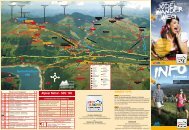
Zell-Gerlos A-Z - Zillertal Arena
Zell-Gerlos A-Z - Zillertal Arena
Zell-Gerlos A-Z - Zillertal Arena

Erfolgreiche ePaper selbst erstellen
Machen Sie aus Ihren PDF Publikationen ein blätterbares Flipbook mit unserer einzigartigen Google optimierten e-Paper Software.
Gehzeit: 1 h bis zur Krummbachrast, 45 min zur Pröller Alm<br />
Einkehren: Pröller Alm, Krummbachrast<br />
Weg: Asphalt, Schotterstraße<br />
the Krummbach valley (summer and winter hiking trail)<br />
The easy hike into the „thumb“ of the five side valleys, the Krummbach<br />
Valley, could also be called hut hopping. Altogether, three huts offering<br />
Austrian snacks and specialties await you on Trail No. 2. From the parking<br />
area at the Isskogel Chairlift the trail leads past the Almstüberl and the<br />
turnoff for Prölleralm - a rustic Alpine hut. Continue, first along the brook,<br />
until you reach the Jausenstation Krummbachrast (snacks), from where<br />
hikers with stamina can take the trail via the Nöckentalalm to the Isskogel<br />
top station.<br />
time: 1 h to the Krummbachrast, 45 min to the Pröller Alm<br />
cafés: Pröller Alm, Krummbachrast<br />
Way: asphalt, gravel road<br />
Wildgerlostal (<strong>Gerlos</strong>) (Sommerwanderweg)<br />
Eine schöne beschauliche Tour (3 Stunden) ist auch die Seerundwanderung<br />
rund um das <strong>Gerlos</strong>er Wassersport-Zentrum Durlaßboden. Beginnend am<br />
Restaurant auf der Dammkrone dem Seestüberl geht es am linken Seeufer<br />
entlang bis zum Eingang des Wildgerlostals. Hier wechselt man dann auf<br />
einen asphaltierten Fahrweg bis zum Alpengasthof Finkau. Von hier kann<br />
man an der Leitenkammerklamm vorbei zur malerisch gelegenen Zittauer<br />
Hütte (2.329 m) am Wildgerlossee aufsteigen. Oder man genießt eine Jause<br />
im Gasthof Finkau - mit imposantem Blick auf die bis 3.300 m hohen Gipfel<br />
der Reichenspitzgruppe - und spaziert dann am Seeufer entlang über die<br />
Jausenstation Bärschlagalm wieder zurück zur Dammkrone zum Seestüberl.<br />
Am Fuße der Dammkrone befindet sich der Parkplatz oder man überquert die<br />
Hauptstraße und folgt dem Weg durchs Innertal zurück nach <strong>Gerlos</strong>.<br />
Gehzeit: 3 h (Rundwanderweg)<br />
Einkehren: Seestüberl, Bärschlagalm, Gasthaus Finkau<br />
Weg: Asphalt, Schotterweg, Kinderwagentauglich über<br />
Bärschlagalm bis Finkau<br />
the Wildgerlos valley (summer hiking trail)<br />
For a nice peaceful hike (3 hrs.) take the trail around the <strong>Gerlos</strong> Water<br />
Sports Center Durlassboden. Start out from the Seestüberl restaurant at<br />
the crest of the dam and go along the left of the reservoir to the beginning<br />
of the Wildgerlos Valley, where you pick up a blacktop road to the<br />
Alpengasthof Finkau. From here you climb past the Leitenkammerklamm<br />
(gorge) to the picturesque Zittauer Hut (2,329 m) on Wildgerlossee (lake).<br />
Or you can stop for a snack at the Gasthof Finkau with its impressive<br />
view of the 3,300-m peaks of the Reichenspitzgruppe and then walk back<br />
along the reservoir past the Jausenstation Bärschlagalm (snacks) to the<br />
Seestüberl on the crest of the dam. At the foot of the dam is a parking area,<br />
or you can cross the road and take the trail through Inner Valley back to<br />
<strong>Gerlos</strong>.<br />
time: 3 h (around the lake)<br />
cafés: Seestüberl, Bärschlagalm, Gasthaus Finkau<br />
Way: asphalt, gravel road, walking with baby carriage<br />
possible via Bärschlagalm to Finkau<br />
Wiesenweg (<strong>Gerlos</strong>) (Sommer- und Winterwanderweg)<br />
Die Wanderung über den <strong>Gerlos</strong>er Wiesenweg beginnt im Ortsteil Innertal<br />
beim Parkplatz der Isskogel-Talstation. Vor der Krummbach-Brücke führt<br />
die Straße links vorbei am Landhaus Platzer. Nach ca. 100 m zweigt<br />
der asphaltierte Fahrweg rechts ab. Immer dem <strong>Gerlos</strong>er Wiesenweg<br />
bergauf folgend gelangt man gemütlich in ca. 1 Stunde zur Jausenstation<br />
„Rösslalm“. Von dort führt ein markierter Wanderweg in rund 40 Minuten<br />
über saftige Almwiesen und an der Bergstation „Isskogel“ vorbei zur<br />
Jausenstation „Latschenalm“.<br />
Gehzeit: ca. 1 h bis zur Rösslalm,<br />
ca. 1 h 40 min bis zur Latschenalm<br />
Einkehren: Rösslalm, Latschenalm<br />
Weg: Asphalt, Schotterstraße, Kinderwagentauglich bis Rösslalm<br />
<strong>Gerlos</strong>er Wiesenweg path (summer and winter hiking trail)<br />
The hike along the <strong>Gerlos</strong> Wiesenweg path begins in the district of<br />
Innertal at the car park for the Isskogel Valley Station. Before reaching<br />
Krummbach Bridge, the road leads to the left past Landhaus Platzer.<br />
After approximately 100 m, this paved road turns to the right. Follow<br />
the <strong>Gerlos</strong> Wiesenweg uphill to reach the refreshment station, ‘Rössalm’,<br />
comfortably in approximately 1 hour. From here, a marked hiking path<br />
runs for around 40 minutes across lush Alpine meadows and past the<br />
‘Isskogel’ to a refreshment break at the ‘Latschenalm’ pasture.<br />
time: approx. 1 h to the Rösslalm,<br />
approx. 1 h 40 min to the Latschenalm<br />
cafés: Rösslalm, Latschenalm<br />
Way: asphalt, gravel road, walking with baby carriage possible<br />
Weiteres Informationsmaterial für Wanderer und Bergsteiger<br />
erhalten sie in den Büros des tourismusverbandes <strong>Zell</strong>-<strong>Gerlos</strong><br />
sowie in Ihren unterkünften.<br />
Find further information material on hiking and mountaineering<br />
in the offices of the tourist association <strong>Zell</strong>-<strong>Gerlos</strong> and in your<br />
accomodation.<br />
tHEMENWEGE tHEMED pAtHs<br />
ZEll<br />
Holzweg<br />
Vom Ausgangspunkt Zillerbrücke gelangt man links vom Autohaus Huber<br />
zum Start. Der Holzweg führt über einen Kreuzweg, vorbei an der Josef-<br />
Kapelle, hinauf zur Herz-Jesu-Kapelle und zum Gasthof Schulhaus. Von<br />
dort ein kurzes Stück entlang der Straße, weiter durch dichten Wald<br />
talwärts und man gelangt über die Eugenpromenade zurück zur Josef-<br />
Kapelle und zum Ausgangspunkt im Tal. Er macht den Wald in all seinen<br />
Facetten für die Wanderer erlebbar, sensibilisiert die Sinne und weckt<br />
mit interaktiver Wissensvermittlung auch Neugierde und Spieltrieb der<br />
Besucher. Dieser Erlebnisweg soll das Bewusstsein der Menschen für<br />
den Lebensraum vor der eigenen Haustüre stärken. Ein Summstein,<br />
eine überdimensionale Duftbeere, eine Station mit verschiedenen Vogelstimmen<br />
und viele weitere Erlebnisstationen machen den Wald erlebbar.<br />
Gehzeit: ca. 2 - 3 h, Wanderschuhe erforderlich!<br />
Ausgangspunkt: Zillerbrücke - <strong>Zell</strong>bergeben<br />
Höhenunterschied: ca. 250 m<br />
schwierigkeitsgrad: mittel bis schwer<br />
Einkehrmöglichkeiten: Gasthof Schulhaus<br />
Wandern<br />
38<br />
39