Zell-Gerlos A-Z - Zillertal Arena
Zell-Gerlos A-Z - Zillertal Arena
Zell-Gerlos A-Z - Zillertal Arena

Sie wollen auch ein ePaper? Erhöhen Sie die Reichweite Ihrer Titel.
YUMPU macht aus Druck-PDFs automatisch weboptimierte ePaper, die Google liebt.
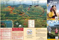
lAuF- uND NorDIc WAlKING-trAIls<br />
ZEll<br />
Beginners-run: 2,5 km<br />
Kurzcharakter: Kurze, flache Einsteigerrunde entlang des Zillers<br />
schwierigkeitsgrad: leicht<br />
Höhenmeter: 4 m<br />
untergrund: Schotterwege, Asphalt<br />
streckenverlauf:<br />
Der Beginners Run führt vom Freizeitpark Richtung Süden flussaufwärts, immer<br />
direkt am Ziller entlang. Nach etwa 1,2 km quert man den Zillerfluss und<br />
gelangt auf der anderen Uferseite zurück zum Startpunkt.<br />
Beginners-run: 2.5 km<br />
General information: short, flat circular route suitable for beginners along the<br />
edge of the Ziller River<br />
level of difficulty: easy<br />
Elevation difference: 4 m<br />
surface conditions: gravel tracks, asphalt<br />
route:<br />
The Beginners’ Run starts at the Leisure Park and leads southwards closely<br />
following the river upstream. After approx. 1.2 km, the route takes you across<br />
the Ziller River and back to the starting point.<br />
Ziller-run: 4,7 km<br />
Kurzcharakter: Kurze, flache Trainingsstrecke am Ziller<br />
schwierigkeitsgrad: leicht<br />
Höhenmeter: 8 m<br />
untergrund: Schotterwege, Asphalt<br />
streckenverlauf:<br />
Der Ziller-Run führt wie der Beginners Run flussaufwärts, hat seinen<br />
Wendepunkt aber erst am Laimacher Steg. Dadurch ergibt sich eine<br />
4,7 km lange Runde direkt entlang des Flusses.<br />
Ziller-run: 4.7 km<br />
General information: short, flat training route along the Ziller<br />
level of difficulty: easy<br />
Elevation difference: 8 m<br />
surface conditions: gravel track, asphalt<br />
Route:<br />
The Ziller Run starts off similarly to the Beginner´s Run following the river<br />
upstream, but the turning point comes somewhat further on, namely at the<br />
Laimacher Steg bridge, making the circuit 4.7 km long in total.<br />
promenadenlauf: 5,9 km<br />
Kurzcharakter: Umrundung von <strong>Zell</strong> entlang der beiden<br />
Hauptbäche auf flachen breiten Wegen<br />
schwierigkeitsgrad: leicht<br />
Höhenmeter: 21 m<br />
untergrund: Schotterwege, Asphalt<br />
streckenverlauf:<br />
Vom Freizeitpark Richtung Norden führt die Strecke immer am Ziller entlang<br />
bis zur Mündung des <strong>Gerlos</strong>bachs. Diesem folgt man flussaufwärts bis zur<br />
Kaiserstadt. Weiter Richtung Süden bis zur Unterführung, dann bis zum<br />
Tannerhof, wo man über Wiesen und Felder wieder zurück zum Ziller und weiter<br />
zum Startpunkt gelangt.<br />
promenade run: 5.9 km<br />
General information: Circular route on flat, wide paths around the village of<br />
<strong>Zell</strong> following the course of the two main streams<br />
level of difficulty: easy<br />
Elevation difference: 21 m<br />
surface conditions: gravel tracks, asphalt<br />
route:<br />
Starting at the recreation park, the route takes you northwards along the edge<br />
of the Ziller River to where the <strong>Gerlos</strong>bach stream joins the river. Follow the<br />
<strong>Gerlos</strong>bach upstream to Kaiserstadt and then continue in a southerly direction to<br />
the underpass and on to the Tannerhof hotel where you can cross the fields and<br />
meadows back to the Ziller River and to the starting point.<br />
<strong>Zell</strong>berg-schleife: 8,5 km<br />
Kurzcharakter: Anspruchsvolle, landschaftlich wunderschöne<br />
und sehr abwechslungsreiche Runde<br />
schwierigkeitsgrad: schwierig<br />
Höhenmeter: 320 m<br />
untergrund: Schotterwege, Waldwege, Asphalt<br />
streckenverlauf:<br />
Über die Brücke beim Freizeitpark gelangt man auf die andere Seite des Zillers,<br />
wo man flussabwärts vor der Zillerbrücke links abbiegt. Der Beschilderung<br />
Eugenweg/Holzweg folgend, gelangt man zur Josef-Kapelle. Vorbei an der<br />
Kapelle führt der Weg, mit Ausnahme eines kurzen Straßenstücks, immer auf<br />
Wald- und Forstwegen am Hang entlang taleinwärts. Die Schlüsselstelle der<br />
Strecke stellt ein kurzer Abschnitt im Bereich des Talbach Wasserfalls dar, wo<br />
man über sehr steile Stiegen diesen landschaftlich reizvollen Abschnitt überwindet.<br />
Kurz vor Hippach führt die Strecke wieder ins Tal. Vom Ortsteil Laimach<br />
weiter bis zum Laimachersteg, wo die Strecke links über die Zillerpromenade<br />
wieder zum Ausgangspunkt beim Freizeitpark führt.<br />
<strong>Zell</strong>berg loop: 8.5 km<br />
General information: Challenging but scenically breathtaking route,<br />
full of variety<br />
level of difficulty: difficult<br />
Elevation difference: 320 m<br />
surface conditions: gravel tracks, forest trails, asphalt<br />
route:<br />
Cross the bridge at Leisure Park to the other side of the Ziller River and turn<br />
right. Just before you reach the Ziller bridge turn left (downstream). Follow<br />
the signs for Eugenweg/Holzweg to the Josefkapelle chapel. After the chapel,<br />
the route follows the hillside along forest trails all the way (apart from on short<br />
section on the road) towards the valley. The most interesting part of this route<br />
is a short section near the Talbach Waterfall where some very steep steps take<br />
you up through particularly breathtaking scenery. Just short of the hamlet of<br />
Hippach, the trail leads back down into the valley. From the hamlet of Laimach<br />
continue to the Laimachersteg bridge where the circuit continues left along the<br />
Ziller River Promenade back to the starting point at the recreation park.<br />
Wandern<br />
44<br />
45