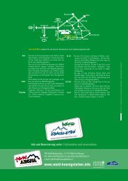
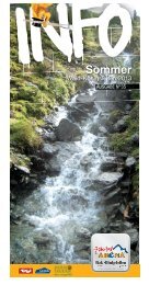
Zell-Gerlos A-Z - Zillertal Arena
Zell-Gerlos A-Z - Zillertal Arena
Zell-Gerlos A-Z - Zillertal Arena

Sie wollen auch ein ePaper? Erhöhen Sie die Reichweite Ihrer Titel.
YUMPU macht aus Druck-PDFs automatisch weboptimierte ePaper, die Google liebt.
Hainzenberg round trip trail<br />
If you go along the <strong>Gerlos</strong>straße from the town centre you will reach the<br />
Gasthof Waldheim. On the right-hand side, Hiking Path No. 8 leads via<br />
beautiful crossroads stops to the Maria Rast pilgrimage church, one of the<br />
most beautiful stops in the round hike. Continue via the show cheese dairy,<br />
the <strong>Zillertal</strong> gold show mine and the old school in Dörfl district. By this time<br />
the greatest ascent has been overcome. Via an old mule-track, the round<br />
hike leads to the Brigitte Stone. A long time ago, an old hut stood here,<br />
in which a woman called Brigitte lived. Directly next to this hut there was<br />
a flat, shiny stone, on which she did her washing. The story tells that no<br />
snow remained on this stone, which was retained until 1965, even when it<br />
had snowed a lot! Along the vividly described stops, you turn back via the<br />
Wischberg and return to the starting point. Also along this route, some cosy<br />
inns invite you to rest.<br />
Walking time: approx. 2 - 3 h, hiking boots required!<br />
starting point: Gasthof Waldheim<br />
Elevation gain: approx. 350 meters<br />
Difficulty: moderate to severe<br />
cafés: Gasthof Waldheim, Gasthof Waidachhof,<br />
Kiosk bei der Schaukäserei mit kleinem Tierpark,<br />
Familienhotel Dörflwirt, Ferienhotel Jörglerhof<br />
Nordic Walking trail<br />
Der Nordic Walking Trail führt von der Bergstation der Rosenalmbahn/<br />
<strong>Zillertal</strong> <strong>Arena</strong>, auf 1.744 m, zunächst zu Simon´s Bergstadl und weiter zur<br />
Kreuzjochhütte, auf 1.980 m, auf der Sie das weitläufige Alpenpanorama<br />
genießen, und sich mit Speis und Trank stärken können! (Länge: hin und<br />
retour: 4,8 km) Ein Powertrail führt dann in Serpentinen auf 2.065 m (hin<br />
und retour: 2,5 km, Höhenunterschied: 160 m). Die Tafeln, gestaltet in<br />
Form von überdimensionalen Nordic Walking Stöcken, zeigen das richtige<br />
Aufwärmen, die Technik, Entspannungsübungen und vieles mehr!<br />
Gehzeit: ca. 1 h 30 min<br />
Ausgangspunkt: Rosenalm, Bergstation der Rosenalmbahn/<strong>Zillertal</strong><br />
<strong>Arena</strong><br />
Höhenunterschied: ca. 230 m<br />
schwierigkeitsgrad: mittel<br />
Einkehrmöglichkeiten: Kreuzjochhütte, Simon’s Bergstadl, Kreithütte<br />
The Nordic walking trail leads from the Rosenalmbahn/<strong>Zillertal</strong> <strong>Arena</strong><br />
top station at 1,744 m to Simon‘s Bergstadl and then it continues to the<br />
Panoramaplatz (ca. 2,050 m) above the Kreuzjochhütte hut. The length of<br />
the walk, there and back, amounts to 4.8 km. The tables - designed in the<br />
form of oversized Nordic walking sticks - show the correct warming up, the<br />
technique, various relaxtion exercises and lots more! At the Kreuzjochhütte<br />
you can enjoy the sweeping panorama of the Alps and strengthen yourself<br />
with food and drink.<br />
starting point: Rosenalm<br />
Walking time: approx. 1 h 30 min<br />
Elevation gain: approx. 230 meters<br />
Difficulty: medium<br />
cafés: Kreuzjochhütte, Simon’s Bergstadl, Kreithütte<br />
tHEMENWEGE ruND uM GErlos<br />
Erlebnisreich Weg<br />
Von <strong>Gerlos</strong> nach <strong>Gerlos</strong>-Gmünd erleben Sie in verschiedenen Stationen die<br />
Beziehung zwischen Mensch und Ökologie – für Kinder wie für Erwachsene<br />
lehrreiche Natur- und Sinneserfahrungen! Der Weg Erlebnisreich bietet<br />
darüber hinaus auch künstlerische Impressionen, die Ihnen anhand von<br />
3 Meter hohen Skulpturen aus Baumstämmen und Gestein, dargeboten<br />
werden.<br />
Gehzeit: ca. 1 h ab <strong>Arena</strong>Funten-Club (Ortszentrum)<br />
Experience path<br />
From <strong>Gerlos</strong> to <strong>Gerlos</strong>-Gmünd you will experience the relationship between<br />
humans and ecology at various stations – an educational, nature and sensory<br />
adventure for children and adults!<br />
The Experience Path also offers artistic impressions brought to you in 3<br />
metre sculptures made of tree trunks and stone.<br />
Walking time: approx 1 h from <strong>Arena</strong>Funten-Club (town centre)<br />
tierlehrpfad<br />
Vom Gasthof Kühle Rast geht’s durch einen schmalen Waldgürtel des<br />
Schwarzachtales langsam bergauf. Etwa eine Stunde lang wird in dem<br />
engen, romantischen Tal an der Schwarzach entlang gewandert.<br />
Auf 1.400 m winkt die Jausenstation Schwarzachalm zur Einkehr.<br />
Schautafeln entlang des Weges mit den heimischen Tieren (Gämsen, Adler,<br />
Murmeltier etc.)<br />
Gehzeit: ca. 1 h ab Gasthof Kühle Rast<br />
Animal Nature trail<br />
Starting from the Gasthof Kühle Rast, the trail ascends slowly through a<br />
narrow belt of forest. You can walk for approximately 1 hour in this narrow,<br />
romantic valley along the Schwarzach River. At 1,400 m you can take a<br />
refreshment break at the Schwarzachalm Pasture.<br />
Charts along the path show native animals (chamois goats, eagles, marmots,<br />
etc.).<br />
Walking time: approx. 1 h from Gasthof Kühle Rast.<br />
Wandern<br />
Fischlehrpfad<br />
Von <strong>Gerlos</strong>-Oberwirt links der Hauptstraße, beim Isskogel-Parkplatz vorbei<br />
zu den letzten Häusern im Innertal bis zur Krummbachbrücke. Nach deren<br />
Überschreitung geht man nach einer Linkskurve gleich rechts, in östlicher<br />
Richtung in das Tal Funsingau. 20 Minuten danach wird der Weg enger und<br />
zieht sich romantisch am linken Bachufer des <strong>Gerlos</strong>baches bis kurz vor die<br />
Staumauer. Noch ein Stück der Bundesstraße entlang und man erreicht die<br />
Dammkrone des Durlaßboden-Stausees. Einkehrmöglichkeit im Seestüberl<br />
an der Dammkrone.<br />
Gehzeit: ca. 1 h ab Krummbachbrücke<br />
Fish Nature trail<br />
From <strong>Gerlos</strong>-Oberwirt on the left side of the main road, past the Isskogel<br />
car park, to the last houses in the Innertal Valley and on to Krummbach<br />
Bridge. After crossing the bridge, turn right just after a left bend and walk<br />
east into Funsingau Valley. After 20 minutes, the path becomes narrower<br />
and cuts romantically into the left bank of the <strong>Gerlos</strong>bach River until just<br />
before the dam wall. After another section along the main road, we reach<br />
the dam crest of the Durlaßboden Reservoir. You can then take a break at<br />
the Seestüberl restaurant at the dam crest.<br />
Walking time: approx. 1 h from the Krummbach bridge<br />
42<br />
43