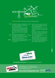
Zell-Gerlos A-Z - Zillertal Arena
Zell-Gerlos A-Z - Zillertal Arena
Zell-Gerlos A-Z - Zillertal Arena

Sie wollen auch ein ePaper? Erhöhen Sie die Reichweite Ihrer Titel.
YUMPU macht aus Druck-PDFs automatisch weboptimierte ePaper, die Google liebt.
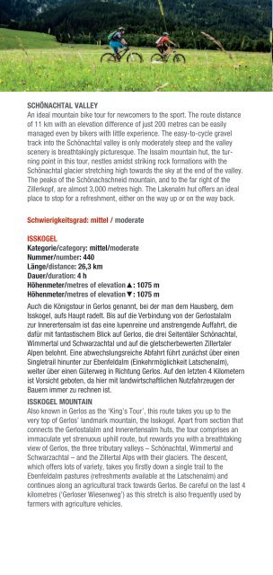
scHöNAcHtAl vAllEY<br />
An ideal mountain bike tour for newcomers to the sport. The route distance<br />
of 11 km with an elevation difference of just 200 metres can be easily<br />
managed even by bikers with little experience. The easy-to-cycle gravel<br />
track into the Schönachtal valley is only moderately steep and the valley<br />
scenery is breathtakingly picturesque. The Issalm mountain hut, the turning<br />
point in this tour, nestles amidst striking rock formations with the<br />
Schönachtal glacier stretching high towards the sky at the end of the valley.<br />
The peaks of the Schönachschneid mountain, and to the far right of the<br />
Zillerkopf, are almost 3,000 metres high. The Lakenalm hut offers an ideal<br />
place to stop for a refreshment, either on the way up or on the way back.<br />
schwierigkeitsgrad: mittel / moderate<br />
IssKoGEl<br />
Kategorie/category: mittel/moderate<br />
Nummer/number: 440<br />
länge/distance: 26,3 km<br />
Dauer/duration: 4 h<br />
Höhenmeter/metres of elevation▲: 1075 m<br />
Höhenmeter/metres of elevation▼: 1075 m<br />
Auch die Königstour in <strong>Gerlos</strong> genannt, bei der man dem Hausberg, dem<br />
Isskogel, aufs Haupt radelt. Bis auf die Verbindung von der <strong>Gerlos</strong>talalm<br />
zur Innerertensalm ist das eine lupenreine und anstrengende Auffahrt, die<br />
dafür mit fantastischem Blick auf <strong>Gerlos</strong>, die drei Seitentäler Schönachtal,<br />
Wimmertal und Schwarzachtal und auf die gletscherbewerten <strong>Zillertal</strong>er<br />
Alpen belohnt. Eine abwechslungsreiche Abfahrt führt zunächst über einen<br />
Singletrail hinunter zur Ebenfeldalm (Einkehrmöglichkeit Latschenalm),<br />
weiter über einen Güterweg in Richtung <strong>Gerlos</strong>. Auf den letzten 4 Kilometern<br />
ist Vorsicht geboten, da hier mit landwirtschaftlichen Nutzfahrzeugen der<br />
Bauern immer zu rechnen ist.<br />
IssKoGEl MouNtAIN<br />
Also known in <strong>Gerlos</strong> as the ‘King’s Tour’, this route takes you up to the<br />
very top of <strong>Gerlos</strong>’ landmark mountain, the Isskogel. Apart from section that<br />
connects the <strong>Gerlos</strong>talalm and Innerertensalm huts, the tour comprises an<br />
immaculate yet strenuous uphill route, but rewards you with a breathtaking<br />
view of <strong>Gerlos</strong>, the three tributary valleys – Schönachtal, Wimmertal and<br />
Schwarzachtal – and the <strong>Zillertal</strong> Alps with their glaciers. The descent,<br />
which offers lots of variety, takes you firstly down a single trail to the<br />
Ebenfeldalm pastures (refreshments available at the Latschenalm) and<br />
continues along an agricultural track towards <strong>Gerlos</strong>. Be careful on the last 4<br />
kilometres (‘<strong>Gerlos</strong>er Wiesenweg’) as this stretch is also frequently used by<br />
farmers with agriculture vehicles.<br />
KruMMBAcHtAl<br />
Kategorie/category: mittel/moderate<br />
Nummer/number: 445<br />
länge/distance: 9,9 km<br />
Dauer/duration: 1 h<br />
Höhenmeter/metres of elevation▲: 205 m<br />
Höhenmeter/metres of elevation▼: 205 m<br />
Biken<br />
Vom Ausgangspunkt Musikpavillon führt die Dorfstraße an der Isskogelbahn<br />
vorbei in den Ortsteil Innertal. Weiter der asphaltierten Straße folgend bis<br />
zum Almstüberl, dann gabelt sich der Güterweg nach rund einem Kilometer.<br />
Nach links führt der Weg zur Jausenstation Prölleralm hinauf. Wir folgen<br />
jedoch dem Güterweg geradeaus, einige Kehren etwas steiler bergauf und<br />
dann wieder halbflach hin zur gemütlichen Krummbachrast.<br />
KruMMBAcHtAl vAllEY<br />
Starting at the music pavilion, follow the main road through the village past<br />
the Isskogelbahn cable-car to the area called Innertal. Continue along the<br />
tarmac road to the Almstüberl restaurant. After around one kilometre the<br />
agricultural track forks. The left fork leads up to the Pröller Alm mountain<br />
hut, but we continue straight ahead along the agricultural track and up some<br />
sharps bends, several of which are somewhat steeper, before continuing<br />
along a semi-flat stretch to the convivial Krummbachrast hut.<br />
roHrBErG – rosENAlM – GErlosBErG ruNDE<br />
Kategorie/category: mittel/moderate<br />
länge/distance: 26,1 km<br />
Dauer/duration: 2,5 h<br />
Höhenmeter/metres of elevation▲: 1165 m<br />
Höhenmeter/metres of elevation▼: 1165 m<br />
Zum Aufwärmen durch das Ortszentrum von <strong>Zell</strong> Richtung <strong>Gerlos</strong>berg und<br />
nach der Brücke <strong>Gerlos</strong>berg/Rohrberg werden das erste mal die Muskeln<br />
gefragt. Die steile Strecke lässt nur einmal beim Gasthof Grindlalm auf<br />
der ca. 500 m langen flachen Strecke Gelegenheit zum Luft holen. Bei der<br />
Wiesenalm wechselt der Straßenbelag von Asphalt auf Schotter und nach<br />
ca. 4 km erreichen Sie eine der schönsten Almlandschaften des <strong>Zillertal</strong>s<br />
mit herrlichem Blick auf die Tuxer Voralpen. Nach der Schweißtreibenden<br />
Auffahrt erwartet Sie zur Belohnung eine schonende Abfahrt über den<br />
<strong>Gerlos</strong>berg.<br />
roHrBErG-rosENAlM-GErlosBErG tour<br />
To warm up, cycle through the village centre of <strong>Zell</strong> towards the <strong>Gerlos</strong>berg<br />
mountain and, after the <strong>Gerlos</strong>berg/Rohrberg bridge, you can start really<br />
using your muscles. During the steep ascent, there’s only one section – a<br />
flat, 500 m-long stretch near the Gasthof Grindlalm inn – that offers you a<br />
breather. At the Wiesenalm hut, the road surface changes from tarmac to<br />
gravel and, after around 4 km, you come to one of the most picturesque<br />
pasture landscapes in the <strong>Zillertal</strong> valley complete with a breathtaking view<br />
of the foothills of the Tux Alps. After the strenuous ascent, you’re rewarded<br />
with a fantastic descent down the <strong>Gerlos</strong>berg mountain.<br />
52<br />
53