Prof. Günther Vogt - ETH Zürich
Prof. Günther Vogt - ETH Zürich
Prof. Günther Vogt - ETH Zürich

Erfolgreiche ePaper selbst erstellen
Machen Sie aus Ihren PDF Publikationen ein blätterbares Flipbook mit unserer einzigartigen Google optimierten e-Paper Software.
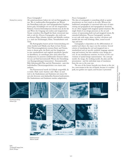
Entwurf ws 2006/07<br />
Projektentwicklung<br />
Hanael Sfez<br />
links:<br />
Tischmodell image from<br />
Rachel Metzger<br />
Process Cartography I<br />
Als spatial practitioners haben wir viel mit Kartographie zu<br />
tun. Wo es traditionellen Kartographen um Weisen<br />
der Darstellung realer geo- und topographischer Gegebenheiten<br />
geht, beschäftigen wir uns oft mit imaginierten<br />
Räumen. Unseren Entwurfsprozess könnte man als die Art<br />
und Weise des Umgangs mit realem und imaginiertem<br />
Terrain verstehen. Den Begriff der Karte erweiternd, handelt<br />
es sich bei «Process Cartography» also nicht nur<br />
um Karten, Pläne, Schnitte, Ansicht und Modelle, sondern<br />
u. a. auch um Zeichnungen, Filme, Tonaufnahmen und<br />
Texte.<br />
Die Kartographie basiert auf der Unterscheidung zwischen<br />
Symbol und Objekt; eine Karte ist kein Terrain.<br />
Viele Übersetzungskriterien trennen Karte und Terrain,<br />
wenn es darum geht, das Reale und das Imaginierte<br />
in eine standardisierte und zugleich spezifische Sprache<br />
zu überführen, sie unterliegen aber auch jedem Entwurfsprozess.<br />
In unserem einführenden Semester haben<br />
wir uns auf fünf konventionelle Weisen der Darstellung<br />
von Raumgestaltungen konzentriert – Konzeptmodell,<br />
Bild, Arbeitsmodell, Plan und die Präsentation – samt den<br />
individuellen Übersetzungsschritten von einem zum<br />
anderen.<br />
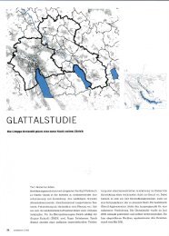
Das Kasernenareal wurde als Gelände ausgewählt, da<br />
es weder «Park» noch «Garten» oder «Platz» ist und<br />
weil es die Studentinnen und Studenten mit einem Ort<br />
mit sehr diversem sozio-kulturellen Kontext konfrontierte.<br />
Die Studentinnen und Studenten wurden aufgefordert,<br />
Endpräsentation<br />
Martin Staubli<br />
211<br />
Process Cartography I<br />
The idea of cartography is something which as spatial<br />
practitioners we have much to do with. Whereas the<br />
traditional cartographer is concerned with ways of representing<br />
real geographical and topographical situations,<br />
we are often engaged with imagined spatial situations. We<br />
might think of our design processes as the art and<br />
science of representing both real and imagined terrain. By<br />
extended definition, ‘Process Cartography’ provides<br />
us not only with maps, plans, sections, elevations and<br />
models but also with drawings, films, sound recordings<br />
and texts.<br />
Cartography is dependent on the differentiation of<br />
symbol and object; the map is not the territory. Several<br />
criteria of translating the real and imagined into a<br />
standardized and yet specific symbolic language separate<br />
map and territory, but also underlay every design process.<br />
In our introductory semester, we focus on five conventions<br />
of spatial design representation – the concept<br />
model, the image, the working model, the plan and the<br />
presentation – and the individual steps of translation<br />
from the one to the next one.<br />
The area of the former barracks was chosen as the site<br />
for a new terrain in the city of Zurich, because it is neither<br />
park, nor garden nor square, and because it presented<br />
NSL/Institut ILA Departement Architektur<br />
<strong>Günther</strong> <strong>Vogt</strong>