

1542.158 F - CNATRA
1542.158 F - CNATRA
1542.158 F - CNATRA

You also want an ePaper? Increase the reach of your titles
YUMPU automatically turns print PDFs into web optimized ePapers that Google loves.
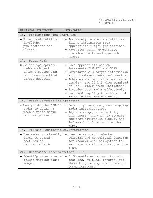
BEHAVIOR STATEMENT STANDARDS<br />
16. Publications and Chart Use<br />
● Effectively utilize<br />
in-flight<br />
publications and<br />
charts.<br />
IX-9<br />
<strong>CNATRA</strong>INST <strong>1542.158</strong>F<br />
25 AUG 11<br />
● Accurately locates and utilizes<br />
flight information from<br />
appropriate flight publications.<br />
● Navigates using appropriate<br />
high/low charts and approach<br />
plates.<br />
17. Radar Work<br />
● Select appropriate ● Uses appropriate search<br />
radar mode and<br />
increments IAW FTI and STAN.<br />
antenna sector scan ● Correlates AIC target information<br />
to enhance earliest with displayed radar information.<br />
target detection. ● Achieves and maintains best radar<br />
display (spotlight) when required<br />
or until radar track initiation.<br />
● Troubleshoots radar effectively.<br />
● Uses mode agility to achieve and<br />
maintain best radar display.<br />
18. Radar Controls and Operation<br />
● Manipulate the APG-66<br />
radar to obtain a<br />
usable radar scope<br />
for navigation.<br />
19. Terrain Consideration/Integration<br />
● Use radar or visually<br />
distinct terrain<br />
features as<br />
navigation aids.<br />
20. Radarscope Interpretation (RSI)<br />
● Identify returns on a<br />
ground mapping radar<br />
scope.<br />
● Correctly executes ground mapping<br />
radar initialization.<br />
● Adjusts range, antenna tilt,<br />
brightness, and gain to acquire<br />
the best navigation display and<br />
information 80 percent of the<br />
time.<br />
● Uses terrain and selected<br />
cultural and noncultural features<br />
for radar/visual navigation to<br />
maintain position accuracy within<br />
1 NM.<br />
● Differentiates between terrain<br />
features, cultural returns, far<br />
shore brightening, and lines of<br />
communications.


