Jenner Bombing Target Archive Search Report Findings
Jenner Bombing Target Archive Search Report Findings
Jenner Bombing Target Archive Search Report Findings

You also want an ePaper? Increase the reach of your titles
YUMPU automatically turns print PDFs into web optimized ePapers that Google loves.
4 SITE HISTORY<br />
4.1 HISTORICAL SITE SUMMARY<br />
4.1.1 General Site History<br />
Section 4 – History<br />
Page 14<br />
ARCHIVES SEARCH REPORT – FINDINGS<br />
<strong>Jenner</strong> 12th Naval District <strong>Target</strong> No. 29<br />
<strong>Jenner</strong>, CA<br />
The Navy built <strong>Jenner</strong> 12th Naval District <strong>Target</strong> No. 29 as one of over thirty bombing<br />
and rocket targets within the 12th Naval District in California and Nevada during World<br />
War II. <strong>Target</strong> No. 29 was directly associated with Naval Auxiliary Air Station (NAAS)<br />
Santa Rosa, which was approximately 20 miles to the east. NAAS Santa Rosa was one of<br />
a dozen subordinate NAAS and Naval Air Station (NAS) activities under the 12 th Naval<br />
District, Naval Air Bases at NAS Alameda. The 12 th Naval District officially established<br />
NAAS Santa Rosa on 29 June 1943, a year and a half prior to acquisition of <strong>Target</strong> No.<br />
29. NAAS Santa Rosa had a total of three subordinate range activities, including divebombing<br />
and rocket targets:<br />
Petaluma 12th Naval District <strong>Target</strong> No. 9 i<br />
<strong>Jenner</strong>12th Naval District <strong>Target</strong> No. 29<br />
Stewart’s Point 12th Naval District <strong>Target</strong> No. 30 10<br />
Before acquiring the property for the <strong>Jenner</strong> bomb target, the Navy received approval<br />
from the Interdepartmental Air Traffic Control Board (IATCB) for the target location at<br />
N38 o 26' 00", W123 o 07' 00” on 26 July 1944 (though given to the second, the<br />
coordinates are an approximation). Although the 1.5-mile radius Danger Area for this<br />
site was published on Aeronautical Charts as early as 7 December 1944, the Navy had not<br />
received real estate rights to the site. By the 14 th , the “targets for this site have been<br />
constructed and the area is now suitably improved for use” and condemnation<br />
proceedings were requested for the Navy to take immediate possession of the land. The<br />
Navy acquired leases for the two parcels of land on 29 December 1944. 11<br />
Although aligned with NAAS Santa Rosa, the bomb and rocket targets within the 12 th<br />
Naval District appear to have been available for use by the dozens of subordinate<br />
activities under the Naval District command along with the Army. 12<br />
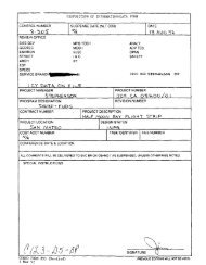
The research found no documentation in regards to specifics of the layout for <strong>Target</strong> No.<br />
29, though a site map shows it to be a single circular target. Typical 12 th Naval District<br />
dive bombing targets on land were suppose to consist of a 250 foot cleared area, with an<br />
interior 50 foot radius, 4 foot wide, wooden plank circle. The target center was to be a<br />
12-foot square platform with a 3-foot diameter bull’s eye. A typical dive-bombing target<br />
might also have additional markings along the two axes in line with rake stations, though<br />
i The Saint Louis District is concurrently preparing ASRs on <strong>Target</strong>s No. 9 and No. 30, at Petaluma and<br />
Stewart’s Point. The project numbers are J09CA7298 and J09CA1032.