Groundwater arsenic in the Red River delta, Vietnam ... - Fiva
Groundwater arsenic in the Red River delta, Vietnam ... - Fiva
Groundwater arsenic in the Red River delta, Vietnam ... - Fiva

You also want an ePaper? Increase the reach of your titles
YUMPU automatically turns print PDFs into web optimized ePapers that Google loves.
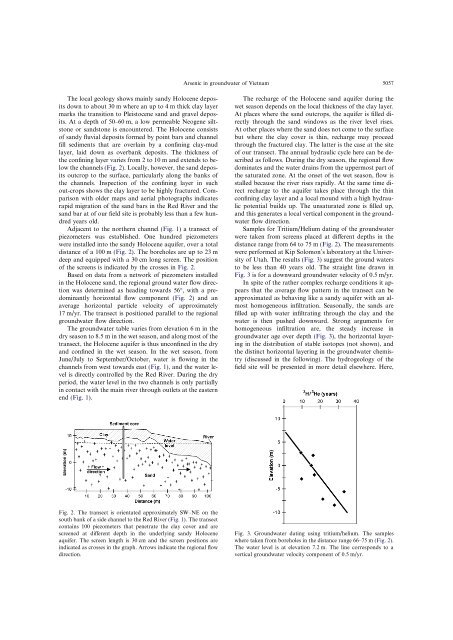
The local geology shows ma<strong>in</strong>ly sandy Holocene deposits<br />
down to about 30 m where an up to 4 m thick clay layer<br />
marks <strong>the</strong> transition to Pleistocene sand and gravel deposits.<br />
At a depth of 50–60 m, a low permeable Neogene siltstone<br />
or sandstone is encountered. The Holocene consists<br />
of sandy fluvial deposits formed by po<strong>in</strong>t bars and channel<br />
fill sediments that are overla<strong>in</strong> by a conf<strong>in</strong><strong>in</strong>g clay-mud<br />
layer, laid down as overbank deposits. The thickness of<br />
<strong>the</strong> conf<strong>in</strong><strong>in</strong>g layer varies from 2 to 10 m and extends to below<br />
<strong>the</strong> channels (Fig. 2). Locally, however, <strong>the</strong> sand deposits<br />
outcrop to <strong>the</strong> surface, particularly along <strong>the</strong> banks of<br />
<strong>the</strong> channels. Inspection of <strong>the</strong> conf<strong>in</strong><strong>in</strong>g layer <strong>in</strong> such<br />
out-crops shows <strong>the</strong> clay layer to be highly fractured. Comparison<br />
with older maps and aerial photographs <strong>in</strong>dicates<br />
rapid migration of <strong>the</strong> sand bars <strong>in</strong> <strong>the</strong> <strong>Red</strong> <strong>River</strong> and <strong>the</strong><br />
sand bar at of our field site is probably less than a few hundred<br />
years old.<br />
Adjacent to <strong>the</strong> nor<strong>the</strong>rn channel (Fig. 1) a transect of<br />
piezometers was established. One hundred piezometers<br />
were <strong>in</strong>stalled <strong>in</strong>to <strong>the</strong> sandy Holocene aquifer, over a total<br />
distance of a 100 m (Fig. 2). The boreholes are up to 23 m<br />
deep and equipped with a 30 cm long screen. The position<br />
of <strong>the</strong> screens is <strong>in</strong>dicated by <strong>the</strong> crosses <strong>in</strong> Fig. 2.<br />
Based on data from a network of piezometers <strong>in</strong>stalled<br />
<strong>in</strong> <strong>the</strong> Holocene sand, <strong>the</strong> regional ground water flow direction<br />
was determ<strong>in</strong>ed as head<strong>in</strong>g towards 56°, with a predom<strong>in</strong>antly<br />
horizontal flow component (Fig. 2) and an<br />
average horizontal particle velocity of approximately<br />
17 m/yr. The transect is positioned parallel to <strong>the</strong> regional<br />
groundwater flow direction.<br />
The groundwater table varies from elevation 6 m <strong>in</strong> <strong>the</strong><br />
dry season to 8.5 m <strong>in</strong> <strong>the</strong> wet season, and along most of <strong>the</strong><br />
transect, <strong>the</strong> Holocene aquifer is thus unconf<strong>in</strong>ed <strong>in</strong> <strong>the</strong> dry<br />
and conf<strong>in</strong>ed <strong>in</strong> <strong>the</strong> wet season. In <strong>the</strong> wet season, from<br />
June/July to September/October, water is flow<strong>in</strong>g <strong>in</strong> <strong>the</strong><br />
channels from west towards east (Fig. 1), and <strong>the</strong> water level<br />
is directly controlled by <strong>the</strong> <strong>Red</strong> <strong>River</strong>. Dur<strong>in</strong>g <strong>the</strong> dry<br />
period, <strong>the</strong> water level <strong>in</strong> <strong>the</strong> two channels is only partially<br />
<strong>in</strong> contact with <strong>the</strong> ma<strong>in</strong> river through outlets at <strong>the</strong> eastern<br />
end (Fig. 1).<br />
Fig. 2. The transect is orientated approximately SW–NE on <strong>the</strong><br />
south bank of a side channel to <strong>the</strong> <strong>Red</strong> <strong>River</strong> (Fig. 1). The transect<br />
conta<strong>in</strong>s 100 piezometers that penetrate <strong>the</strong> clay cover and are<br />
screened at different depth <strong>in</strong> <strong>the</strong> underly<strong>in</strong>g sandy Holocene<br />
aquifer. The screen length is 30 cm and <strong>the</strong> screen positions are<br />
<strong>in</strong>dicated as crosses <strong>in</strong> <strong>the</strong> graph. Arrows <strong>in</strong>dicate <strong>the</strong> regional flow<br />
direction.<br />
Arsenic <strong>in</strong> groundwater of <strong>Vietnam</strong> 5057<br />
The recharge of <strong>the</strong> Holocene sand aquifer dur<strong>in</strong>g <strong>the</strong><br />
wet season depends on <strong>the</strong> local thickness of <strong>the</strong> clay layer.<br />
At places where <strong>the</strong> sand outcrops, <strong>the</strong> aquifer is filled directly<br />
through <strong>the</strong> sand w<strong>in</strong>dows as <strong>the</strong> river level rises.<br />
At o<strong>the</strong>r places where <strong>the</strong> sand does not come to <strong>the</strong> surface<br />
but where <strong>the</strong> clay cover is th<strong>in</strong>, recharge may proceed<br />
through <strong>the</strong> fractured clay. The latter is <strong>the</strong> case at <strong>the</strong> site<br />
of our transect. The annual hydraulic cycle here can be described<br />
as follows. Dur<strong>in</strong>g <strong>the</strong> dry season, <strong>the</strong> regional flow<br />
dom<strong>in</strong>ates and <strong>the</strong> water dra<strong>in</strong>s from <strong>the</strong> uppermost part of<br />
<strong>the</strong> saturated zone. At <strong>the</strong> onset of <strong>the</strong> wet season, flow is<br />
stalled because <strong>the</strong> river rises rapidly. At <strong>the</strong> same time direct<br />
recharge to <strong>the</strong> aquifer takes place through <strong>the</strong> th<strong>in</strong><br />
conf<strong>in</strong><strong>in</strong>g clay layer and a local mound with a high hydraulic<br />
potential builds up. The unsaturated zone is filled up,<br />
and this generates a local vertical component <strong>in</strong> <strong>the</strong> groundwater<br />
flow direction.<br />
Samples for Tritium/Helium dat<strong>in</strong>g of <strong>the</strong> groundwater<br />
were taken from screens placed at different depths <strong>in</strong> <strong>the</strong><br />
distance range from 64 to 75 m (Fig. 2). The measurements<br />
were performed at Kip Solomon’s laboratory at <strong>the</strong> University<br />
of Utah. The results (Fig. 3) suggest <strong>the</strong> ground waters<br />
to be less than 40 years old. The straight l<strong>in</strong>e drawn <strong>in</strong><br />
Fig. 3 is for a downward groundwater velocity of 0.5 m/yr.<br />
In spite of <strong>the</strong> ra<strong>the</strong>r complex recharge conditions it appears<br />
that <strong>the</strong> average flow pattern <strong>in</strong> <strong>the</strong> transect can be<br />
approximated as behav<strong>in</strong>g like a sandy aquifer with an almost<br />
homogeneous <strong>in</strong>filtration. Seasonally, <strong>the</strong> sands are<br />
filled up with water <strong>in</strong>filtrat<strong>in</strong>g through <strong>the</strong> clay and <strong>the</strong><br />
water is <strong>the</strong>n pushed downward. Strong arguments for<br />
homogeneous <strong>in</strong>filtration are, <strong>the</strong> steady <strong>in</strong>crease <strong>in</strong><br />
groundwater age over depth (Fig. 3), <strong>the</strong> horizontal layer<strong>in</strong>g<br />
<strong>in</strong> <strong>the</strong> distribution of stable isotopes (not shown), and<br />
<strong>the</strong> dist<strong>in</strong>ct horizontal layer<strong>in</strong>g <strong>in</strong> <strong>the</strong> groundwater chemistry<br />
(discussed <strong>in</strong> <strong>the</strong> follow<strong>in</strong>g). The hydrogeology of <strong>the</strong><br />
field site will be presented <strong>in</strong> more detail elsewhere. Here,<br />
Fig. 3. <strong>Groundwater</strong> dat<strong>in</strong>g us<strong>in</strong>g tritium/helium. The samples<br />
where taken from boreholes <strong>in</strong> <strong>the</strong> distance range 66–75 m (Fig. 2).<br />
The water level is at elevation 7.2 m. The l<strong>in</strong>e corresponds to a<br />
vertical groundwater velocity component of 0.5 m/yr.