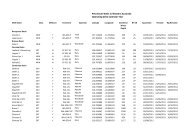
IN WESTERN AUSTRALIA - Department of Mines and Petroleum
IN WESTERN AUSTRALIA - Department of Mines and Petroleum
IN WESTERN AUSTRALIA - Department of Mines and Petroleum

You also want an ePaper? Increase the reach of your titles
YUMPU automatically turns print PDFs into web optimized ePapers that Google loves.
Angel<br />
The Angel field is a gas/condensate discovery<br />
located approximately 50 km east <strong>of</strong> North Rankin<br />
platform. The discovery is currently being assessed<br />
for future development potential, with the possibility<br />
<strong>of</strong> development being undertaken for a 2007/08<br />
startup.<br />
Searipple<br />
The Searipple field was discovered in 1996 by the<br />
deepened Perseus 3A appraisal well. Development<br />
plans are in progress in conjunction with the further<br />
development <strong>of</strong> the Perseus field.<br />
Egret<br />
Egret is a small oilfield approximately 12 km<br />
northwest <strong>of</strong> the Wanaea field <strong>and</strong> is currently under<br />
appraisal. The most recent (Egret 3) appraisal well<br />
was drilled in June 2003 finding a gas <strong>and</strong> oil<br />
column. The decision on future development will be<br />
taken in 2004/05, post acquisition <strong>of</strong> new seismic.<br />
Dockrell<br />
The Dockrell field is located 6 km southeast <strong>of</strong> the<br />
Echo/Yodel field <strong>and</strong> 20 km southwest <strong>of</strong> the<br />
Goodwyn A platform, in 110 m water depth. The<br />
field was discovered in 1973 by Dockrell 1, which<br />
encountered gross gas <strong>and</strong> oil columns <strong>of</strong> 88 m <strong>and</strong><br />
14 m respectively, in the Jurassic Brigadier (D Unit)<br />
<strong>and</strong> Triassic Mungaroo (E Unit) Formations. The<br />
Brigadier Formation is a dominantly shaly interval<br />
with thinly interbedded s<strong>and</strong>s, deposited in a<br />
shallow marine delta front setting. The E Unit is a<br />
high energy, s<strong>and</strong> dominated, fluvio-deltaic,<br />
sequence. Reservoir units dip towards the northeast<br />
<strong>and</strong> are truncated by MU. Regionally extensive<br />
Cretaceous shales provide the seal to the<br />
accumulation. Two additional thin hydrocarbon<br />
zones were encountered within Unit F <strong>of</strong> the<br />
Mungaroo Formation some 300 <strong>and</strong> 550 m below<br />
the base <strong>of</strong> the Unit E. Dockrell 2 was drilled in<br />
1998 to test the reservoir units to the north <strong>of</strong> the<br />
Dockrell field. Two oil-bearing reservoir units, the E<br />
s<strong>and</strong> (Dockrell 1) <strong>and</strong> D s<strong>and</strong> (Dockrell 2), have<br />
been penetrated.<br />
The field is covered by the Keast 3D seismic survey<br />
acquired in 1997, which provided improved<br />
structural <strong>and</strong> fault definition. Reprocessing <strong>of</strong> the<br />
Keast 3D data was conducted during 2003.<br />
Timing <strong>of</strong> the development <strong>of</strong> the Dockrell field,<br />
which is located within the Goodwyn field<br />
production licence, is dictated by gas supply<br />
dem<strong>and</strong> <strong>and</strong> is anticipated for a later date.<br />
Development is likely to consist <strong>of</strong> a sub-sea<br />
development tied-back to GWA.<br />
Keast<br />
The Keast field is located 4 km southeast <strong>of</strong> the<br />
Echo/Yodel field <strong>and</strong> 20 km southwest <strong>of</strong> the<br />
Goodwyn A platform, in 125 m water depth. Keast 1<br />
was drilled in January 1997 <strong>and</strong> encountered a<br />
gross gas column <strong>of</strong> 32 m in the Jurassic Unit D<br />
(Brigadier Formation). Gas was also encountered in<br />
Unit E, Intra E, <strong>and</strong> Lower E s<strong>and</strong>s <strong>of</strong> the Triassic<br />
Mungaroo Formation. Both the D <strong>and</strong> E Unit s<strong>and</strong>s<br />
dip northwards <strong>and</strong> sub-crop below the regional<br />
unconformity (MU). Cretaceous shales above MU<br />
seal the accumulation. The Intra E <strong>and</strong> Lower E<br />
s<strong>and</strong>s are structurally trapped beneath intraformational<br />
shales.<br />
Unit D is a claystone-dominated interval with<br />
occasional interbedded s<strong>and</strong>s, deposited in a<br />
shallow marine, delta front setting. The E Unit is a<br />
high energy, s<strong>and</strong>-dominated, fluvio-deltaic<br />
sequence. Unit E s<strong>and</strong>s are thick <strong>and</strong> are<br />
interpreted to be really extensive. Keast 2 was<br />
drilled in March 1997, to test the hydrocarbonbearing<br />
potential <strong>of</strong> the Lower Jurassic C Unit <strong>and</strong> D<br />
Unit to the north. The well intersected a shaly, nonreservoir<br />
D Unit beneath MU. S<strong>and</strong>s deeper withithe<br />
D Unit, structurally lower than the gas column<br />
encountered in the sub-cropping D Unit at Keast 1,<br />
were water bearing. The current seismic (Keast 3D<br />
survey) provides reliable structural definition <strong>and</strong><br />
further improvements may be realised through<br />
interpretation <strong>of</strong> the Keast 3D reprocessed data.<br />
Development timing for the Keast field, which is<br />
located within the Goodwyn field production licence,<br />
is anticipated at a later date <strong>and</strong> will be dictated by<br />
gas supply dem<strong>and</strong>. Development will most likely<br />
rely upon a depletion-drive recovery <strong>and</strong> is likely to<br />
consist <strong>of</strong> a sub-sea development tied-back to GWA.<br />
Wilcox<br />
The Wilcox field is located approximately 55 km<br />
southwest <strong>of</strong> the Goodwyn A platform in 70 m water<br />
depth. Wilcox 1 was drilled in March 1983 <strong>and</strong><br />
discovered a 500 m gross column within thick<br />
fluvio-deltaic beds <strong>of</strong> the Triassic Mungaroo<br />
PWA April Edition - 2003 Review 21<br />
Formation. The field lies within a large Triassic fault<br />
block bound to the northwest by a steeply dipping<br />
fault. There are four gas-bearing s<strong>and</strong>s in the E, F,<br />
<strong>and</strong> G Units. Wilcox 2 was drilled down-flank in<br />
June 1985 to prove additional reserves, but all<br />
s<strong>and</strong>s were found to be water bearing.<br />
First production from Wilcox is not expected until a<br />
later date. Development will most likely rely upon a<br />
depletion-drive recovery <strong>and</strong> is likely to consist <strong>of</strong> a<br />
sub-sea development tied-back to GWA.<br />
In 2000, the retention lease WA-7-R was renewed<br />
over the block where the field is located.<br />
Sculptor<br />
The Sculptor field comprises <strong>of</strong> several fault blocks<br />
<strong>and</strong> encompasses both the Lower-E <strong>and</strong> F Units <strong>of</strong><br />
the Triassic Mungaroo Formation.<br />
The field is covered by the Keast 3D seismic data,<br />
which was acquired in 1997. A volumetric update to<br />
reflect 3D seismic data was completed during 2002.<br />
Development timing for Sculptor is anticipated at a<br />
later date <strong>and</strong> will be dictated by gas supply<br />
dem<strong>and</strong>. Development will most likely rely upon a<br />
depletion-drive recovery <strong>and</strong> is likely to consist <strong>of</strong> a<br />
sub-sea development tied-back to GWA.<br />
In 2001, the production licence WA-24-L was<br />
granted over the field area thus changing the blocks<br />
status from retention lease (WA-11-R) to production<br />
licence. DoIR<br />
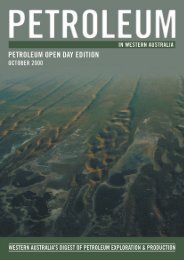
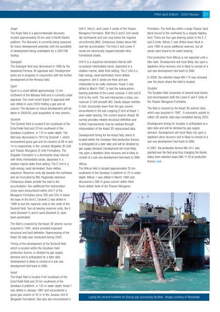
Laying the second trunkline for Burrup gas processing facilities (Image courtesy <strong>of</strong> Woodside)