CBD Fourth National Report - Azerbaijan (English version)
CBD Fourth National Report - Azerbaijan (English version)
CBD Fourth National Report - Azerbaijan (English version)

You also want an ePaper? Increase the reach of your titles
YUMPU automatically turns print PDFs into web optimized ePapers that Google loves.
Country Study on Biodiversity and <strong>Fourth</strong> <strong>National</strong> <strong>Report</strong><br />
The Republic of <strong>Azerbaijan</strong><br />
irrigates more than 1300 ha of drought prone land. The channels also carry clean water to a<br />
number of settlements, although approximately 40% of fresh water in <strong>Azerbaijan</strong> is taken<br />
from subsoil reserves.<br />
As more than of territory of <strong>Azerbaijan</strong> Republic situated in arid climate condition, a lack of<br />
water appeared here permanently. Demand for water is not same in separate parts of Kura<br />
river due to varied nature and diversified agriculture along its basin.<br />
Key water facilities related to hydrographic network - rivers, lakes and water reservoirs were<br />
allotted irregularly in different natural provinces of <strong>Azerbaijan</strong> Republic.<br />
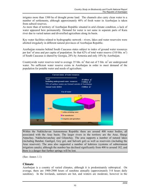
<strong>Azerbaijan</strong> remains behind South Caucasus states subject to index of ground water resources<br />
per km 2 of area and per capita of population. So that 62% of total water reserve (310 bln. m 3 )<br />
of South Caucasus is shared by Georgia, 28% by Armenia and only 10% by <strong>Azerbaijan</strong>.<br />
Countrywide water reserves total to average 35 bln. m 3 that out of 5 bln. m 3 are underground<br />
water. No sufficient water reserve exists in <strong>Azerbaijan</strong> in order to meet demand of the<br />
population for potable water and needs of agriculture.<br />
Within the Nakhichevan Autonomous Republic there are around 400 water bodies, all<br />
associated with the Araz basin. The larger rivers in the territory are the Araz, Shargi<br />
Arpachay, Nakhichevanchay and Gilanchay. The area supports a number of natural lakes<br />
(including Batabat, Ganligol, Goy gol, and Salvarti gol) as well as reservoirs (including the<br />
Araz reservoir). The area also supported a number of kahrizes (systems of subterranean<br />
irrigation canals), although the number has declined significantly from 400 to around 182, and<br />
there is a danger that further springs will be lost.<br />
(See: Annex 1.1)<br />
Total 35 billion m 3<br />
Including underground water resources<br />
: 5 billion m 3<br />
70% of surface waters are formed outside of <strong>Azerbaijan</strong><br />
Annual water deficit 4 billion m 3<br />
62%<br />
Current status of water resources<br />
Use of water<br />
welfare-drinking water<br />
for manufacture<br />
irrigation and agriculture<br />
Climate<br />
<strong>Azerbaijan</strong> is a country of varied climates, although it is predominately subtropical. On<br />
average, there are 1900-2900 hours of sunshine annually (approximately 5-8 hours daily<br />
sunshine). In the lowlands, summers are hot, and winters are moderate, however in the<br />
10<br />
7%<br />
31%<br />
2009<br />
770