CBD Fourth National Report - Azerbaijan (English version)
CBD Fourth National Report - Azerbaijan (English version)
CBD Fourth National Report - Azerbaijan (English version)

You also want an ePaper? Increase the reach of your titles
YUMPU automatically turns print PDFs into web optimized ePapers that Google loves.
Country Study on Biodiversity and <strong>Fourth</strong> <strong>National</strong> <strong>Report</strong><br />
The Republic of <strong>Azerbaijan</strong><br />
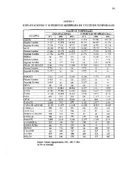
agrarian policy. Namely, additional land plot of 0.44 million ha was involved to agriculture of<br />
the republic. There exist some improvements in irrigation of the lands, too. Increase of<br />
irrigated lands appeared mainly in low-lying regions. However, share of countrywide dryfarming<br />
is comprised by 30% of all arable lands that these lands are mainly situated in<br />
mountainous and low-lying regions.<br />
Quantity of soil reserve per family is various in regions of the republic because of the<br />
population settlement. Despite this figure totalled to 0.85 ha in Lankaran-Astara region, but it<br />
equals to 5.9 ha in Absheron region and to 2-3 ha plains (lowland region). Nevertheless<br />
14.5% of rural population inhabited here, 19.7% of the soil is located in this area. Most<br />
unsuitable lands are situated in Nakhichevan and Lankaran-Astara regions. Accordingly 7.4<br />
and 12.5% population inhabited here, arable lands total to 3-5%.<br />
36.0% (595.6 thousand ha) of countrywide farmings were brought together in Lowland<br />
economic region. Also, Lowland economic region is comprised by 12.6% of farmings<br />
remained under state ownership, 38.4% of farmings remained under municipality ownership<br />
and 41.4% of farmings remained under private ownership. 6.5% of economic regions’<br />
farmings are under state ownership, 5.7% under municipality ownership and 87.8% under<br />
private ownership.<br />
The following places are taken by Mountainous Garabagh, Ganja-Gazakh and Shaki-Zagatala<br />
economic regions subject to quantity of total area of the arable lands. 34.3% of countrywide<br />
farmings are located in these regions and remaining parts are in other economic regions.<br />
First three places are taken by Nakhichevan (93.3%), Mountainous Shirvan (89.1%) and<br />
Lowland (87.8%) economic regions subject to quantity of the arable lands used under private<br />
ownership. This figure totals to 41.8% in Absheron.<br />
In view of specific geographical situation of Absheron economic region, location of Baku and<br />
Sumgayit cities in this region and development of industry, forms of arable lands are<br />
distinctive as compared to other regions.<br />
Perennial croppings take particular place among agricultural lands. The perennial croppings<br />
cover gardens, vineyards, tea plantations, berries and other fields. There existed 158.5<br />
thousand perennial plants and renascents in 2003 in the republic and area of them reached to<br />
161.5 thousand ha by increasing 3.0 thousand ha within the past period (2008). 38.8% of<br />
these lands are still under state ownership (including Mountainous Garabagh and occupied<br />
regions), 2.83% under municipal ownership and 58.4% under private ownership. Subject to<br />
total area of perennial croppings, Shaki-Zagatala (25.8%) and Guba-Khachmaz (17.4%)<br />
economic regions are ahead actually.<br />
72% of countrywide perennial croppings are comprised by Mountainous Garabagh together<br />
with economic regions. However it is a pity that 70% of Mountainous Garabagh are under<br />
occupation. 28.0% of perennial arable fields involves the remaining 7 economic regions.<br />
93.1% of perennial farmings in Guba-Khachmaz economic regions are under private<br />
ownership presently. 40.0% of countrywide perennial croppings are comprised by gardens.<br />
48% of gardens on overall property forms are located in Shaki-Zagatala and 39.0% in Guba-<br />
Khachmaz economic regions.<br />
Nevertheless total area of noncropped lands equalled to 53.0 thousand ha in 2003, this figure<br />
totalled to 41.76 thousand ha by decreasing as 11.24 thousand ha in 2008. 34.6% of these<br />
19<br />
2009