Wetland I.D. Guide - Island County Government
Wetland I.D. Guide - Island County Government
Wetland I.D. Guide - Island County Government

You also want an ePaper? Increase the reach of your titles
YUMPU automatically turns print PDFs into web optimized ePapers that Google loves.
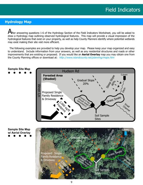
hydrology Map<br />
9<br />
Field Indicators<br />
After answering questions 1-6 of the Hydrology Section of the Field Indicators Worksheet, you will be asked to<br />
draw a Hydrology map outlining observed hydrological features. This map will provide a visual impression of the<br />
hydrological features that exist on your property, as well as help <strong>County</strong> Planners identify where potential wetlands<br />
may exist making their site visit more efficient.<br />
The following examples are provided to help you develop your map. Please keep your map organized and easy<br />
to understand. Include information from your answers, as well as any residential structures and roads or other<br />
improvements that are existing or proposed. If you would like an Aerial overlay map you may obtain one from<br />
the <strong>County</strong> Planning offices or download at: http://www.islandcounty.net/planning/maps.htm<br />
Sample Site Map<br />
Sample Site Map<br />
w/ Aerial Overlay<br />
Wren Ln<br />
Forested Area<br />
(shaded)<br />
Proposed Single<br />
Family Residence<br />
& Driveway<br />
Proposed Single<br />
Family Residence<br />
& Driveway<br />
2,000 sq/ft<br />
Footprint<br />
Hudson Rd<br />
2,000 sq/ft<br />
Footprint<br />
Gradual Slope<br />
20%<br />
Change in Veg.<br />
(Slough Sedge &<br />
Salmonberry)<br />
Slope<br />
Gradual Slope<br />
20% Steep<br />
Change in Veg.<br />
(Slough Sedge &<br />
Salmonberry)<br />
Soil Sample<br />
Sites<br />
Soil Sample<br />
Sites<br />
Steep Slope<br />
40%<br />
Grass Swale<br />
40%<br />
Grass Swale<br />
Culvert<br />
Ditch<br />
Small<br />
Channel<br />
Culvert<br />
Ditch<br />
Small<br />
Channel