Wetland I.D. Guide - Island County Government
Wetland I.D. Guide - Island County Government
Wetland I.D. Guide - Island County Government

You also want an ePaper? Increase the reach of your titles
YUMPU automatically turns print PDFs into web optimized ePapers that Google loves.
soIl - Questions 9-11<br />
<strong>Wetland</strong>s contain “hydric soils” that occur as a result of water saturation, significant changes in soil<br />
environment, and/or flooding or ponding that has occurred long enough during the growing season to deprive<br />
the soil of oxygen.<br />
The following will help complete Questions 9-11 in the Soil section in the Field Indicators worksheet.<br />
Remove a soil sample from 12 inches below<br />
the surface, in an area where you believe<br />
there may be a wetland. You may use the<br />
same hole you dug in Question #3.<br />
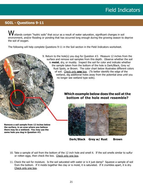
9. Return to the hole(s) you dug for Question #3. Measure 12 inches from the<br />
surface and remove soil samples from this depth. Observe whether the soil<br />
is moist, dry, or muddy. Inspect the soil for color and indicate whether<br />
the sample taken from the bottom of the hole is Dark/Black, Grey w/<br />
Rust Spots, or Brown. The color chart below illustrates different colors<br />
of soil. Check only one box. (To better identify the edge of the<br />
wetland, dig additional holes away from the potential area until you<br />
no longer see wetland type soils).<br />
10. Take a sample of soil from the bottom of the 12 inch hole and smell it. If the soil smells similar to sulfur<br />
or rotten eggs, then check the box. Check only one box.<br />
11. Check the soil for moisture. Is the soil saturated with water or is it just damp? Squeeze a sample of soil<br />
from the bottom. If it molds together like clay or is moist, it is saturated. If it crumbles apart, it is dry.<br />
Check only one box.<br />
21<br />
Field Indicators<br />
Which example below does the soil at the<br />
bottom of the hole most resemble?<br />
dark/Black grey w/ Rust Brown