Wetland I.D. Guide - Island County Government
Wetland I.D. Guide - Island County Government
Wetland I.D. Guide - Island County Government

You also want an ePaper? Increase the reach of your titles
YUMPU automatically turns print PDFs into web optimized ePapers that Google loves.
describe and score the <strong>Wetland</strong> and Its surroundings<br />
1. high priority <strong>Wetland</strong> type<br />
Does all or part of your wetland meet the definition of any of the following wetland types? Maps showing known<br />
locations of these types are available from the <strong>County</strong>. However, not all locations are known, so you should evaluate<br />
your wetland independently to see if it meets these definitions.<br />
___ Bog: A relatively undisturbed <strong>Wetland</strong> with at least seventy percent (70%) ground cover of mosses; or with<br />
water with a pH of less than 5.0; or with more than thirty percent (30%) cover of Sitka Spruce, Western Red<br />
Cedar, Western Hemlock or Lodgepole Pine; and a preponderance of plants that are listed as bog species in Table<br />
3 of the 2004 <strong>Wetland</strong> Rating System prepared by the Washington State Department of Ecology; and having<br />
Peat or Muck soils at least sixteen (16) inches deep. Many Bogs are fed largely by precipitation. <strong>County</strong> maps<br />
identify the location of some but not all Bogs. See also Relict Bog. If the criteria are met, put an “X” the space at<br />
the beginning of this definition. Many Bogs have acidic conditions, low nutrient levels; soils classified as peat or<br />
muck; and are fed largely by precipitation.<br />
___ coastal lagoon <strong>Wetland</strong>: A wetland located within a shallow water body adjacent to marine waters<br />
that is partly or completely separated from Puget Sound by a barrier beach. A Coastal Lagoon receives periodic<br />
influxes of salt water which may occur from storm surges or flow through porous beach sediments. The water<br />
in a Coastal Lagoon is saline or brackish (>0.5 ppt measured near the bottom) during most of the year. If the<br />
criteria are met, put an “X” in the space at the beginning this definition.<br />
___ delta estuary <strong>Wetland</strong>: An Estuarine wetland located directly adjacent to or within a Delta Estuary.<br />
These wetlands are located on the north end of Camano <strong>Island</strong> adjacent to the mouth of the Skagit and<br />
Stillaguamish Rivers. If the criteria are met, put an “X” in the space at the beginning of this definition.<br />
___ estuarine <strong>Wetland</strong>: A tidal wetland containing emergent vegetation that is usually semi-enclosed by land<br />
but has open or partly obstructed access to Puget Sound. If the criteria are met, put an “X” in the space at the<br />
beginning of this definition.<br />
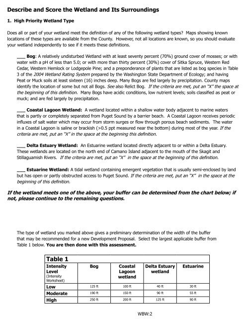
If the wetland meets one of the above, your buffer can be determined from the chart below; if<br />
not, please continue to the remaining questions.<br />
The type of wetland you marked above gives a preliminary determination of the width of the buffer<br />
that may be recommended for a new Development Proposal. Select the largest applicable buffer from<br />
Table 1 below. You are then done with this assessment.<br />
table 1<br />
Intensity<br />
level<br />
(Intensity<br />
Worksheet)<br />
Bog coastal<br />
lagoon<br />
wetland<br />
WBW:2<br />
delta estuary<br />
wetland<br />
estuarine<br />
low 125 ft 100 ft 40 ft 30 ft<br />
Moderate 190 ft 150 ft 90 ft 55 ft<br />
high 250 ft 200 ft 125 ft 90 ft