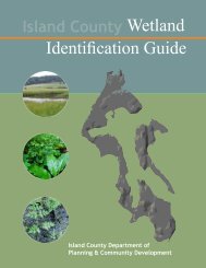
Wetland I.D. Guide - Island County Government
Wetland I.D. Guide - Island County Government
Wetland I.D. Guide - Island County Government

Create successful ePaper yourself
Turn your PDF publications into a flip-book with our unique Google optimized e-Paper software.
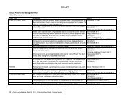
type of land Use development will determine process<br />
Residential Applicants<br />
The chart below illustrates the process and Worksheets<br />
required for Critical Area Review of any proposal for single<br />
family residential land uses. At any step, the applicant<br />
has the option to instead hire a wetland professional to<br />
prepare report(s) which contain the required elements.<br />
ResIdentIAl lAnd Use ApplIcAnt<br />
FIeld IndIcAtoRs WoRksheet<br />
Submit Form to <strong>County</strong> for verification<br />
Yes, there is a wetland<br />
Submit the Following<br />
Worksheets for <strong>County</strong> Review<br />
and Critical Area Determination<br />
lAnd Use IntensItY<br />
WoRksheet<br />
WetlAnd BUFFeR<br />
WoRksheet<br />
no wetland present<br />
Continue with development<br />
process<br />
Alteration may affect ease of identification<br />
2<br />
Working With This <strong>Guide</strong><br />
Non-Residential or Commercial Development<br />
The chart below illustrates the process and Worksheets<br />
required for Critical Area Review of any non-residential or<br />
commercial development land use proposals. The applicant<br />
must retain a wetland professional to prepare report(s)<br />
which contain the required elements.<br />
non-ResIdentIAl lAnd Use ApplIcAnt<br />
FIeld IndIcAtoRs WoRksheet<br />
submit Form completed by a <strong>Wetland</strong><br />
Professional to <strong>County</strong> for verification<br />
Yes, there is a wetland<br />
Submit a <strong>Wetland</strong> Report,<br />
prepared by a <strong>Wetland</strong><br />
professional that contains<br />
the elements of the following<br />
Worksheets for <strong>County</strong> Review<br />
and Critical Area Determination<br />
lAnd Use IntensItY<br />
WoRksheet<br />
WetlAnd BUFFeR<br />
WoRksheet<br />
no wetland present<br />
Continue with development<br />
process<br />
<strong>Wetland</strong> identification is a complex subject, and this simplified guidebook may not be sufficient in every situation.<br />
Some wetlands or their buffers are easy to identify, while others are more complicated. This workbook is<br />
designed primarily for helping landowners identify wetlands that have not been altered or disturbed.<br />
Most alterations to Camano and Whidbey <strong>Island</strong> wetlands happened in the 150 years that preceded <strong>Island</strong><br />
<strong>County</strong>’s adoption of the CAO (Critical Areas Ordinance). Since 1985, these regulations have severely curtailed<br />
alterations to wetlands and associated buffers.<br />
Typical alterations in years past involved clearing of vegetation, plowing or tilling of wetland soil, redirecting<br />
water flow, and grading and filling. Other actions that can cause wetlands to be considered “altered” are ditching,<br />
tiling, draining, compacting, off-site conveyance, herbicide use, and upstream damming (natural or man-made).<br />
Impervious surfaces such as roads and structures also disturb wetland functions by altering the amount of water<br />
and pollutants that enter and exit a wetland.<br />
If a property shows indications that a wetland or buffer has been altered or disturbed, landowners are<br />
encouraged to first consult with <strong>County</strong> Critical Areas Planners to determine the best course of action before<br />
completing the Worksheets in this booklet.