

Geological Survey of Finland, Special Paper 46 - arkisto.gsf.fi
Geological Survey of Finland, Special Paper 46 - arkisto.gsf.fi
Geological Survey of Finland, Special Paper 46 - arkisto.gsf.fi

Create successful ePaper yourself
Turn your PDF publications into a flip-book with our unique Google optimized e-Paper software.
Michigan Lobe as it advanced into terrain vacated<br />
by the Saginaw Lobe. Because <strong>of</strong> their modi<strong>fi</strong> cation<br />
by subsequent advances, these tunnel channels<br />
have been described as palimpsest tunnel channels<br />
(Kehew et al. 1999). Cross-cutting relationships to<br />
be discussed below indicate that after formation,<br />
ice collapsed into the tunnel channel and became<br />
buried by debris, similar to tunnel channels in Denmark<br />
(Jørgensen & Sanderson 2006). This burial<br />
probably delayed melt out <strong>of</strong> the collapsed ice and<br />
formation <strong>of</strong> the valley for a period <strong>of</strong> hundreds to<br />
thousands <strong>of</strong> years.<br />
EXAMPLES OF TUNNEL CHANNEL MORPHOLOGY<br />
AND INFERRED FORMATION<br />
In this section, <strong>fi</strong> ve examples <strong>of</strong> tunnel channels will<br />
be presented to illustrate the range in topography<br />
and post-erosional modi<strong>fi</strong> cation.<br />
Type I Tunnel channels<br />
Type I tunnel channels are generally large and<br />
display the least degree <strong>of</strong> burial (Figs. 4 and 5).<br />
They are interpreted to form by a subglacial burst <strong>of</strong><br />
drainage to an ice margin followed by subsequent<br />
deglaciation without extensive collapse and <strong>fi</strong> lling<br />
with sediment. As a result, they are very distinct<br />
topographic features. Type I tunnel channels in the<br />
study area include both southwest and east-west<br />
Fig. 4. Locations <strong>of</strong> types <strong>of</strong> tunnel channels discussed in text.<br />
Locations shown on Fig. 1. A. Hillshade DEM <strong>of</strong> Thornapple<br />
Valley. B. Contour map made from DEM (countour interval<br />
approximately 3 m.) Kalamazoo Valley is large valley in upper<br />
part <strong>of</strong> diagram. Ice margin is the Kalamazoo Moraine <strong>of</strong> the<br />
Lake Michigan Lobe. C. Contour map made from DEM.<br />
<strong>Geological</strong> <strong>Survey</strong> <strong>of</strong> <strong>Finland</strong>, <strong>Special</strong> <strong>Paper</strong> <strong>46</strong><br />
Tunnel Channels <strong>of</strong> the Saginaw Lobe, Michigan, USA<br />
orientations. The east-west channels cross cut the<br />
southwest trending channels and are interpreted to<br />
be younger.<br />
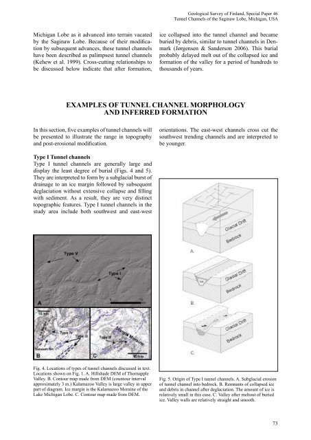
Fig. 5. Origin <strong>of</strong> Type I tunnel channels. A. Subglacial erosion<br />
<strong>of</strong> tunnel channel into bedrock. B. Remnants <strong>of</strong> collapsed ice<br />
and debris in channel after deglaciation. The amount <strong>of</strong> ice is<br />
relatively small in this case. C. Valley after meltout <strong>of</strong> buried<br />
ice. Valley walls are relatively straight and smooth.<br />
73


