tidal hardwood swamps - Maryland Department of Natural Resources
tidal hardwood swamps - Maryland Department of Natural Resources
tidal hardwood swamps - Maryland Department of Natural Resources

You also want an ePaper? Increase the reach of your titles
YUMPU automatically turns print PDFs into web optimized ePapers that Google loves.
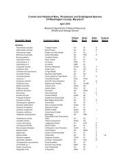
anked S2, designating it as a rare community, with only 6 to 20 estimated occurrences in<br />
<strong>Maryland</strong>. This type may have few remaining acres in the state and is imperiled due to its rarity<br />
and vulnerability to become extirpated. This particular occurrence is part <strong>of</strong> a set <strong>of</strong> similar<br />
communities used to define and classify the community types for the <strong>Maryland</strong> Vegetation<br />
Classification, thus a type locality.<br />
This occurrence is very typical <strong>of</strong> that defined in the Vegetation Description for Fraxinus<br />
pennsylvanica – Acer rubrum / Polygonum ssp. <strong>tidal</strong> woodland (CEGL006165). See the<br />
Vegetation Description section <strong>of</strong> this report for a precise definition <strong>of</strong> this community.<br />
MANAGEMENT COMMENTS / MONITORING NEEDS<br />
Wetlands such as Fraxinus pennsylvanica – Acer rubrum / Polygonum ssp. <strong>tidal</strong> woodlands are<br />
susceptible to many direct and indirect threats. These threats account for significant qualitative<br />
and quantitative changes in wetland community structure, composition, and function. Tiner and<br />
Burke (1995) summarize the major causes <strong>of</strong> wetland loss and degradation in <strong>Maryland</strong> by the<br />
following: 1) Discharges <strong>of</strong> materials (e.g., pesticides, herbicides, other pollutants, nutrient<br />
loading from domestic sewage, urban run<strong>of</strong>f, agricultural run<strong>of</strong>f, and sediments from dredging and<br />
filling projects, agricultural lands, and other land development) into waters and wetlands, 2) Filling<br />
for dredged spoil and other spoil disposal, roads and highways, and commercial, residential, and<br />
industrial development, 3) Dredging and stream channelization for navigation channels, marinas,<br />
flood protection, coastal housing developments, and reservoir maintenance, 4) Construction <strong>of</strong><br />
dikes, dams, levees, and seawalls for flood control, shoreline protection, water supply, and<br />
irrigation, 5) Drainage for crop production, timber production, and mosquito control, 6) Alteration<br />
<strong>of</strong> wetland hydrology and disruption <strong>of</strong> natural river flows through diversion <strong>of</strong> fresh water for<br />
human uses (e.g., water supply, industry, and agriculture), 7) Flooding wetlands for creating<br />
ponds, waterfowl impoundments, reservoirs, and lakes, 8) Clearing <strong>of</strong> native vegetation and<br />
cultivation <strong>of</strong> agricultural crops, 9) Conversion <strong>of</strong> “natural” forested wetlands to pine silviculture<br />
plantations, 10) Sediment diversion by dams, deep channels, and other structures, and 11)<br />
Hydrologic alterations by canals, spoils banks, roads, and other structures. <strong>Natural</strong> threats such<br />
as droughts, subsidence/sea level rise, storm events, erosion, and mechanical damage by wildlife<br />
(e.g., Muskrats, Nutria) could also have severe impacts on forested wetlands systems.<br />
PROTECTION COMMENTS<br />
As part <strong>of</strong> the Patuxent River Park system, this reference site is managed by the <strong>Department</strong> <strong>of</strong><br />
Parks and Recreation. In addition, Fraxinus pennsylvanica – Acer rubrum / Polygonum ssp. <strong>tidal</strong><br />
woodlands found in the Upper portion <strong>of</strong> the Patuxent River occur entirely within the Chesapeake<br />
Bay Critical Area and are therefore subject to further protection regulations.<br />
OCCURRENCE RANK<br />
Supported by data from one vegetation sample plot (listed below), Fraxinus pennsylvanica – Acer<br />
rubrum / Polygonum ssp. <strong>tidal</strong> woodlands in the Upper portion <strong>of</strong> the Patuxent River rank as “A”<br />
or excellent, when compared to all other known <strong>Maryland</strong> examples <strong>of</strong> this community type. This<br />
community has also been located at three other sites in <strong>Maryland</strong>.<br />
MANAGED AREA NAME / TRACT OWNERSHIP<br />
Patuxent River Park, State <strong>of</strong> <strong>Maryland</strong>.<br />
BEST INFORMATION SOURCE<br />
<strong>Maryland</strong> <strong>Natural</strong> Heritage Program, <strong>Maryland</strong> <strong>Department</strong> <strong>of</strong> <strong>Natural</strong> <strong>Resources</strong><br />
UTM COORDINATES<br />
18 351904 E, 4298219 N (PATU001)<br />
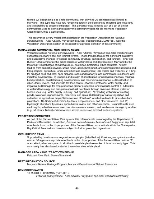
Fraxinus pennsylvanica - Acer rubrum / Polygonum spp. <strong>tidal</strong> woodland community<br />
46