

County Kildare Walking Routes Project - Kildare.ie
County Kildare Walking Routes Project - Kildare.ie
County Kildare Walking Routes Project - Kildare.ie

You also want an ePaper? Increase the reach of your titles
YUMPU automatically turns print PDFs into web optimized ePapers that Google loves.
<strong>County</strong> <strong>Kildare</strong> <strong>Walking</strong> <strong>Routes</strong> <strong>Project</strong><br />
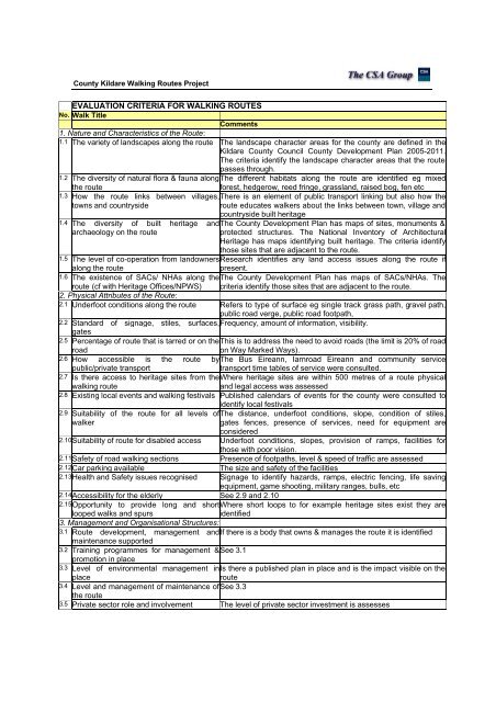
EVALUATION CRITERIA FOR WALKING ROUTES<br />
No. Walk Title<br />
Comments<br />
1. Nature and Characteristics of the Route:<br />
1.1 The var<strong>ie</strong>ty of landscapes along the route The landscape character areas for the county are defined in the<br />
<strong>Kildare</strong> <strong>County</strong> Council <strong>County</strong> Development Plan 2005-2011.<br />
The criteria identify the landscape character areas that the route<br />
passes through.<br />
1.2 The diversity of natural flora & fauna along The different habitats along the route are identif<strong>ie</strong>d eg mixed<br />
the route<br />
forest, hedgerow, reed fringe, grassland, raised bog, fen etc<br />
1.3 How the route links between villages, There is an element of public transport linking but also how the<br />
towns and countryside<br />
route educates walkers about the links between town, village and<br />
countryside built heritage<br />
1.4 The diversity of built heritage and The <strong>County</strong> Development Plan has maps of sites, monuments &<br />
archaeology on the route<br />
protected structures. The National Inventory of Architectural<br />
Heritage has maps identifying built heritage. The criteria identify<br />
those sites that are adjacent to the route.<br />
1.5 The level of co-operation from landowners Research identif<strong>ie</strong>s any land access issues along the route if<br />
along the route<br />
present.<br />
1.6 The existence of SACs/ NHAs along the The <strong>County</strong> Development Plan has maps of SACs/NHAs. The<br />
route (cf with Heritage Offices/NPWS)<br />
2. Physical Attributes of the Route:<br />
criteria identify those sites that are adjacent to the route.<br />
2.1 Underfoot conditions along the route Refers to type of surface eg single track grass path, gravel path,<br />
public road verge, public road footpath,<br />
2.2 Standard of signage, stiles, surfaces, Frequency, amount of information, visibility.<br />
gates<br />
2.5 Percentage of route that is tarred or on the This is to address the need to avoid roads (the limit is 20% of road<br />
road<br />
on Way Marked Ways).<br />
2.6 How accessible is the route by The Bus Eireann, Iarnroad Eireann and community service<br />
public/private transport<br />
transport time tables of service were consulted.<br />
2.7 Is there access to heritage sites from the Where heritage sites are within 500 metres of a route physical<br />
walking route<br />
and legal access was assessed<br />
2.8 Existing local events and walking festivals Published calendars of events for the county were consulted to<br />
identify local festivals<br />
2.9 Suitability of the route for all levels of The distance, underfoot conditions, slope, condition of stiles,<br />
walker<br />
gates fences, presence of services, need for equipment are<br />
considered<br />
2.10 Suitability of route for disabled access Underfoot conditions, slopes, provision of ramps, facilit<strong>ie</strong>s for<br />
those with poor vision.<br />
2.11 Safety of road walking sections Presence of footpaths, level & speed of traffic are assessed<br />
2.12 Car parking available The size and safety of the facilit<strong>ie</strong>s<br />
2.13 Health and Safety issues recognised Signage to identify hazards, ramps, electric fencing, life saving<br />
equipment, game shooting, military ranges, bulls, etc<br />
2.14 Accessibility for the elderly See 2.9 and 2.10<br />
2.15 Opportunity to provide long and short Where short loops to for example heritage sites exist they are<br />
looped walks and spurs<br />
identif<strong>ie</strong>d<br />
3. Management and Organisational Structures:<br />
3.1 Route development, management and If there is a body that owns & manages the route it is identif<strong>ie</strong>d<br />
maintenance supported<br />
3.2 Training programmes for management & See 3.1<br />
promotion in place<br />
3.3 Level of environmental management in Is there a published plan in place and is the impact visible on the<br />
place<br />
route<br />
3.4 Level and management of maintenance of See 3.3<br />
the route<br />
3.5 Private sector role and involvement The level of private sector investment is assesses


