

GPR for river dyke - GSB
GPR for river dyke - GSB
GPR for river dyke - GSB

You also want an ePaper? Increase the reach of your titles
YUMPU automatically turns print PDFs into web optimized ePapers that Google loves.
Turag River, and Buriganga River. A total of 11 regulators at the outfall of khals to the<br />
surrounding <strong>river</strong>s along the embankment. One pumping station at the outfall of Kallyanpur<br />
khal to the Turag River, and another one at the outfall of Dholai khal to the Buriganga River.<br />
These pump stations are <strong>for</strong> draining rainwater from parts of Dhaka West. The main goal of<br />
the test project is to detect risk and flood hazards by details <strong>GPR</strong> (Ground Penetration<br />
Radar) survey on Turag-Buriganga <strong>dyke</strong> detecting weak zones due to fracture/cracks,<br />
organic material, and void space etc. in <strong>dyke</strong>. Locations of test survey areas are shown in<br />
figure 7<br />
4.2.1 <strong>GPR</strong> survey on Tongi Dyke<br />
The geoscientists of <strong>GSB</strong> have carried out a <strong>GPR</strong> survey on Tongi Dyke. They have<br />
selected the sluice gate area <strong>for</strong> their survey location. The starting and ending positions of<br />
data acquisition are 23º49′48″N, 90º49′44″E to 23º49′44″N, 90º20′39″E. The main purpose<br />
of this survey is to locate the sluice gate zone with <strong>GPR</strong>. Figure 8 shows a radargram across<br />
the measurement line.<br />
For collecting a radargram in the sluice gate area a pair of 1.2 m length antennas such as<br />
shown in Figure 4 have been used with 1m spacing between receiving and transmitting<br />
antennas.<br />
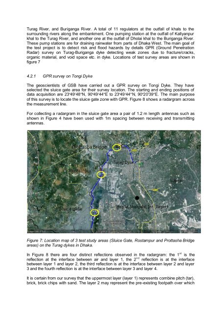
Figure 7: Location map of 3 test study areas (Sluice Gate, Rostampur and Prottasha Bridge<br />
areas) on the Turag <strong>dyke</strong>s in Dhaka.<br />
In Figure 8 there are four distinct reflections observed in the radargram: the 1 st is the<br />
reflection at the interface between air and layer 1, the 2 nd reflection is at the interface<br />
between layer 1 and layer 2, the third reflection is at the interface between layer 2 and layer<br />
3 and the fourth reflection is at the interface between layer 3 and layer 4.<br />
It is certain from our survey that the uppermost layer (layer 1) represents combine pitch (tar),<br />
brick, brick chips with sand. The layer 2 may represent the pre-existing footpath over which