

Volume II - Kildare.ie
Volume II - Kildare.ie
Volume II - Kildare.ie

You also want an ePaper? Increase the reach of your titles
YUMPU automatically turns print PDFs into web optimized ePapers that Google loves.
N7 Naas Road Widening & Interchanges Scheme<br />
Environmental Impact Statement 167<br />
June 2001<br />
<strong>Volume</strong> 2<br />
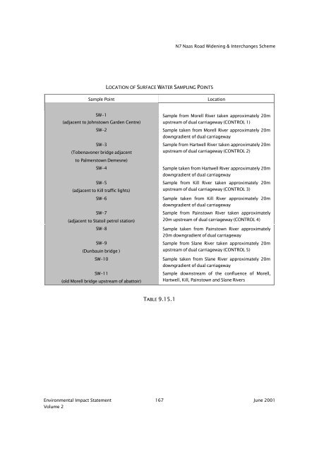
LOCATION OF SURFACE WATER SAMPLING POINTS<br />
Sample Point Location<br />
SW-1<br />
(adjacent to Johnstown Garden Centre)<br />
Sample from Morell River taken approximately 20m<br />
upstream of dual carriageway (CONTROL 1)<br />
SW-2 Sample taken from Morell River approximately 20m<br />
SW-3<br />
(Tobenavoner bridge adjacent<br />
to Palmerstown Demesne)<br />
downgrad<strong>ie</strong>nt of dual carriageway<br />
Sample from Hartwell River taken approximately 20m<br />
upstream of dual carriageway (CONTROL 2)<br />
SW-4 Sample taken from Hartwell River approximately 20m<br />
SW-5<br />
(adjacent to Kill traffic lights)<br />
downgrad<strong>ie</strong>nt of dual carriageway<br />
Sample from Kill River taken approximately 20m<br />
upstream of dual carriageway (CONTROL 3)<br />
SW-6 Sample taken from Kill River approximately 20m<br />
SW-7<br />
(adjacent to Statoil petrol station)<br />
downgrad<strong>ie</strong>nt of dual carriageway<br />
Sample from Painstown River taken approximately<br />
20m upstream of dual carriageway (CONTROL 4)<br />
SW-8 Sample taken from Painstown River approximately<br />
SW-9<br />
(Dunbauin bridge )<br />
20m downgrad<strong>ie</strong>nt of dual carriageway<br />
Sample from Slane River taken approximately 20m<br />
upstream of dual carriageway (CONTROL 5)<br />
SW-10 Sample taken from Slane River approximately 20m<br />
SW-11<br />
(old Morell bridge upstream of abattoir)<br />
TABLE 9.15.1<br />
downgrad<strong>ie</strong>nt of dual carriageway<br />
Sample downstream of the confluence of Morell,<br />
Hartwell, Kill, Painstown and Slane Rivers


