- Page 1 and 2: Over the Beach US Army Amphibious O
- Page 3 and 4: Over the Beach US Army Amphibious O
- Page 5: Foreword The Combat Studies Institu
- Page 8 and 9: Colonel Clark Summers shared his ex
- Page 11 and 12: Contents Page Foreword ............
- Page 13 and 14: Page The Invasion of North Korea ..
- Page 15: Page 16. Incheon Landing overview .
- Page 18 and 19: maintained an amphibious capability
- Page 20 and 21: A Note on Defnitions 5 Most amphibi
- Page 22 and 23: Maneuver from the Sea, Ship-to-Obje
- Page 24 and 25: 6. Unless otherwise indicated, thes
- Page 27 and 28: Chapter 2 Amphibious Heritage Ameri
- Page 29 and 30: craft that came to be known as the
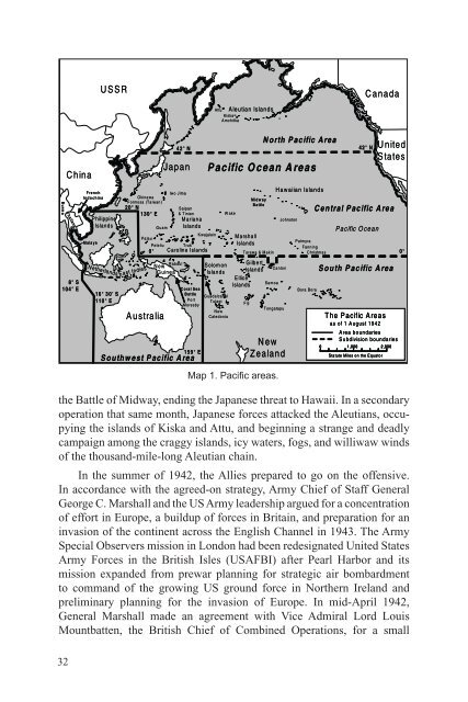
- Page 31 and 32: prows, wooden bulwarks to protect t
- Page 33 and 34: smoothly and, reinforced by some 60
- Page 35 and 36: Pacifc; while Australian forces sei
- Page 37 and 38: Staff organization in February 1942
- Page 39 and 40: Lejeune defned the primary mission
- Page 41 and 42: Army observers participated in the
- Page 43 and 44: 1940 to discuss US-British naval co
- Page 45 and 46: San Diego, California. GHQ exercise
- Page 47: posts for amphibious operations: fr
- Page 51 and 52: crisis diverted shipping and ruled
- Page 53 and 54: The training was to be conducted by
- Page 55 and 56: Thereafter, the Amphibious Force, A
- Page 57 and 58: In the absence of any Navy support
- Page 59 and 60: Japanese submarines, and a storm th
- Page 61 and 62: doctrines, technique, and instructi
- Page 63 and 64: 135° 135 ° 145 145° ° The T he
- Page 65 and 66: 15 August the 7th Infantry Division
- Page 67 and 68: stride. Unfortunately, there were n
- Page 69 and 70: was being planned and so could revi
- Page 71 and 72: Krueger arrived and Sixth Army was
- Page 73 and 74: and the relief was not justifed by
- Page 75 and 76: screens that permitted them to foat
- Page 77 and 78: operations against Japan. Councils
- Page 79 and 80: no way that the 2d ESB’s many lan
- Page 81 and 82: troops. With the 1st ESB providing
- Page 83 and 84: A small amphibious capability was a
- Page 85 and 86: Three major bodies of amphibious ex
- Page 87 and 88: in the seizure or defense of advanc
- Page 89 and 90: the counteroffensive, with amphibio
- Page 91 and 92: Since 1946 advocates for Army amphi
- Page 93 and 94: for naval operations, it could also
- Page 95 and 96: By the time these manuals were publ
- Page 97 and 98: the FEC AOR, but not under MacArthu
- Page 99 and 100:
Beach), and on 1 April 1950 had act
- Page 101 and 102:
study of the history of joint opera
- Page 103 and 104:
the ATS until the creation on 31 Ju
- Page 105 and 106:
47. Ross, American War Plans, 1890-
- Page 107 and 108:
70. Atwater, “Development of Join
- Page 109 and 110:
All-Out, Two-Front War (New York, N
- Page 111 and 112:
Fleet, Lieutenant Colonel Louis B.
- Page 113 and 114:
in World War II, Operations in Nort
- Page 115 and 116:
Infantry Division that began with t
- Page 117 and 118:
Charles R. Anderson, The U.S. Army
- Page 119 and 120:
174. Fahey, Ships and Aircraft of t
- Page 121 and 122:
the Southwest Pacifc, Vol. IV, Amph
- Page 123 and 124:
Operations of Especial Interest to
- Page 125:
Chief of Staff, “Use of SCAJAP Li
- Page 128 and 129:
The T he N orth orth Korean Korean
- Page 130 and 131:
ounds of rapid fre with its 3-inch
- Page 132 and 133:
Command Relationship Changes and Ar
- Page 134 and 135:
Amphibious Planning and Operation B
- Page 136 and 137:
personnel].” He recommended they
- Page 138 and 139:
embarkation ports. So units could m
- Page 140 and 141:
available when the division landed,
- Page 142 and 143:
next day. Doyle headed back for Yok
- Page 144 and 145:
128 i j • Sang jju u JJinju n u
- Page 146 and 147:
NN am am R R to to H adong adong T
- Page 148 and 149:
Regiment, the divisional engineer b
- Page 150 and 151:
destroyers had been diverted to she
- Page 152 and 153:
The T he Tongyeong T ong yeong O pe
- Page 154 and 155:
I 2 2 The T he T Tongyeong ong yeon
- Page 156 and 157:
• • W est Sea S ea (Yellow (Y e
- Page 158 and 159:
Another of Small’s APDs, the Hora
- Page 160 and 161:
on 9 August. There they were traine
- Page 162 and 163:
Notes 1. Joseph S. Bermudez Jr., No
- Page 164 and 165:
7-1-50; Naval Blockade: JCS Message
- Page 166 and 167:
34. Korean War Chronology, 11; Head
- Page 168 and 169:
Institute of the Korean Language st
- Page 170 and 171:
237-239. Field says the raid was th
- Page 172 and 173:
amended his 3 July request for a Ma
- Page 174 and 175:
advised that he intended to commit
- Page 176 and 177:
Marine Colonel Edward H. Forney, th
- Page 178 and 179:
The Marine general, perhaps refecti
- Page 180 and 181:
Because Wolmido had to be secured f
- Page 182 and 183:
just north of the narrow causeway t
- Page 184 and 185:
Marine aircraft would support the l
- Page 186 and 187:
On 5 September the JCS asked MacArt
- Page 188 and 189:
Lieutenant Colonel Smith that, if t
- Page 190 and 191:
Lieutenant Eugene F. Clark, who had
- Page 192 and 193:
frefght, two of the Raiders were ki
- Page 194 and 195:
ships remained aground during the n
- Page 196 and 197:
BLUE Beach, the supply LVTs that ha
- Page 198 and 199:
Since little could be done without
- Page 200 and 201:
In fact, the US planners had left t
- Page 202 and 203:
operational control of the ROK Navy
- Page 204 and 205:
in support of Puller’s 1st Marine
- Page 206 and 207:
LSTs and landing craft and then bro
- Page 208 and 209:
freeing up the 73d Combat Engineers
- Page 210 and 211:
Division had broken through in the
- Page 212 and 213:
commander in chief returned to Toky
- Page 214 and 215:
1/5 M ar Seogang 24 Sep III 3/5 1/K
- Page 216 and 217:
900-foot high mass of Namsan (South
- Page 218 and 219:
had assembled a raft within 6 hours
- Page 220 and 221:
Notes 1. James F. Schnabel, United
- Page 222 and 223:
Shepherd Diary, 21 and 24 August 19
- Page 224 and 225:
Regulations: Operations (Washington
- Page 226 and 227:
55. 1MarDiv, 1st SPBn SAR, 5; 2ESB
- Page 228 and 229:
83. On 24 September the 1st Combat
- Page 230 and 231:
114. Almond Diary, 23 September 195
- Page 233 and 234:
Chapter 5 Operations in North Korea
- Page 235 and 236:
to inform them of the plan, with a
- Page 237 and 238:
(headquartered in Busan). The comma
- Page 239 and 240:
to the west, across the peninsula,
- Page 241 and 242:
operations was established at the p
- Page 243 and 244:
Meanwhile, General Walker’s lead
- Page 245 and 246:
sites, and settled on the beach at
- Page 247 and 248:
the LSTs, LSUs, and LCMs could be t
- Page 249 and 250:
C heong ji jin n H yesan jin jin H
- Page 251 and 252:
Regiment attached to protect Wonsan
- Page 253 and 254:
1 D ec • Suncheon Eighth Arm y y
- Page 255 and 256:
Admiral Doyle sent Transport Divisi
- Page 257 and 258:
O ro-ri ro -ri J i nam po X XX X
- Page 259 and 260:
possible. Normally, LSTs had berthi
- Page 261 and 262:
Notes 1. J. Lawton Collins, War in
- Page 263 and 264:
25. Field, Naval Operations, Korea,
- Page 265 and 266:
M. Almond Papers. MHI Archives Coll
- Page 267 and 268:
Chapter 6 The War of Movement, Dece
- Page 269 and 270:
During the evacuation, the 8206th A
- Page 271 and 272:
along the coastal avenue of approac
- Page 273 and 274:
play out along the rugged coastline
- Page 275 and 276:
operation, the partisan force was e
- Page 277 and 278:
interdict the enemy’s lines of co
- Page 279 and 280:
W est Sea S ea (Yellow (Y ellow Sea
- Page 281 and 282:
128’ 50’ 30 ’ 440’ 20’ Ha
- Page 283 and 284:
some 15 miles north of Wonju. When
- Page 285 and 286:
Han River estuary, and made contact
- Page 287 and 288:
Hwacheon (Hwach’on) Reservoir Ope
- Page 289 and 290:
38 ° • W oncheon-ri Sim po-ri
- Page 291 and 292:
A Bukhan Bukhan RR I 11 Ap Apr r XX
- Page 293 and 294:
the time, and ordered Hoge to carry
- Page 295 and 296:
General Palmer told Colonel Harris
- Page 297 and 298:
HW H W A AC C H EO N D AM A M D ong
- Page 299 and 300:
craters in the road (the DUKWs of t
- Page 301 and 302:
that time, the relief of the brigad
- Page 303 and 304:
SSoyang oyang R R Pyeonggang Chines
- Page 305 and 306:
W est Sea S ea (Yellow (Y ellow Sea
- Page 307 and 308:
Clark L. Ruffner (commanding genera
- Page 309 and 310:
PYEONGYANG-WONSAN Line would be an
- Page 311 and 312:
• • • • W est Sea (Yellow (
- Page 313 and 314:
• Line of C C ontact and East Coa
- Page 315 and 316:
Van Fleet’s proposal for an amphi
- Page 317 and 318:
Notes 1. History of the Korean War,
- Page 319 and 320:
loads carried by the partisans and
- Page 321 and 322:
Hwachon Dam, interviews by First Li
- Page 323 and 324:
73. Webel interview, and interview
- Page 325 and 326:
amphibious operations in the South
- Page 327:
129. Donald W. Boose Jr., “The Ko
- Page 330 and 331:
until July 1951. At that time, the
- Page 332 and 333:
and physical training to bring the
- Page 334 and 335:
Operations in the Offshore Islands
- Page 336 and 337:
landing exercise. Once again lack o
- Page 338 and 339:
einforcement had faded, CINCFE cont
- Page 340 and 341:
The ships carrying the 8th Cavalry
- Page 342 and 343:
11. FEC, Command Report, January 19
- Page 344 and 345:
oard was specifcally exempted from
- Page 346 and 347:
World War II, Transportation Corps
- Page 348 and 349:
By this time in the late 1950s, the
- Page 350 and 351:
“coequal and interdependent.” F
- Page 352 and 353:
Army Forces in Amphibious Operation
- Page 354 and 355:
Cambodian coast. The notional 22d I
- Page 356 and 357:
Army Transportation Corps detachmen
- Page 358 and 359:
modifed LSTs, a barge, and a harbor
- Page 360 and 361:
going ashore in helicopters and LVT
- Page 362 and 363:
of the Army’s amphibious and over
- Page 364 and 365:
the Marine Corps will continue to b
- Page 366 and 367:
Notes 1. Departments of the Army, t
- Page 368 and 369:
23. Crowl, Memorandum, “Critique
- Page 370 and 371:
Headquarters, US Marine Corps, 1984
- Page 372 and 373:
Shawn M. Callahan, The Impact of Fa
- Page 374 and 375:
CONUS Continental United States CP
- Page 376 and 377:
MTT NAVFE NCO NEO NODEX NSC NWP OCO
- Page 379 and 380:
US Military US Army Bibliography De
- Page 381 and 382:
———. Report of the General Bo
- Page 383 and 384:
———. History of the 7th Infan
- Page 385 and 386:
———. Amphibious Exercises, No
- Page 387 and 388:
———. Guerrilla Operations Out
- Page 389 and 390:
———. FM 5-156, Engineer Shore
- Page 391 and 392:
Army Training Tests Army Training T
- Page 393 and 394:
5-525S, Shore Battalion, Engineer B
- Page 395 and 396:
5-649S, Engineer Dredge Crew, Diese
- Page 397 and 398:
20-512R, Headquarters, Headquarters
- Page 399 and 400:
Association of the United States Ar
- Page 401 and 402:
———. Clay and Joan Blair Coll
- Page 403 and 404:
Chapin, John C. Breaching the Maria
- Page 405 and 406:
Creswell, John. Generals and Admira
- Page 407 and 408:
Dyer, George C. The Amphibians Came
- Page 409 and 410:
Garland, Albert N. Amphibious Doctr
- Page 411 and 412:
Hearn, Chester G. Ellet’s Brigade
- Page 413 and 414:
Houghton, Russell T. The Amphibian
- Page 415 and 416:
Kretchik, Walter E., Robert F. Baum
- Page 417 and 418:
Malcom, Ben S., with Ron Martz. Whi
- Page 419 and 420:
Millett, Allan R. “Assault from t
- Page 421 and 422:
Noel, Captain John V. Oral History.
- Page 423 and 424:
Rehkopf, Ned B. “The Landing at G
- Page 425 and 426:
Saipan Controversy,” with additio
- Page 427 and 428:
Sweetman, Jack. The Landing at Vera
- Page 429 and 430:
———. Joint Chiefs of Staff Sp
- Page 431 and 432:
Appendix A Korean Geographical Name
- Page 433:
Sukcheon (Sukch’on) Suncheon (Sun
- Page 436 and 437:
Attack Transport (APA) The Bayfeld
- Page 438 and 439:
Transport (AP) Various types of shi
- Page 440 and 441:
Landing Ship, Dock (LSD) The Gunsto
- Page 442 and 443:
Landing Ship, Medium (LSM) The LSM-
- Page 444 and 445:
Landing Ship, Utility (LSU)/Landing
- Page 446 and 447:
Landing Craft, Vehicle, Personnel (
- Page 448 and 449:
Amphibious 2½-ton Truck (DUKW) A r
- Page 451 and 452:
Appendix C Amphibious Terms, Abbrev
- Page 453 and 454:
Boat assignment table—A table sho
- Page 455 and 456:
Combat loading—The loading of ass
- Page 457 and 458:
Dunnage—Any material, such as boa
- Page 459 and 460:
Landing area—Includes the beach,
- Page 461 and 462:
Naval gunfre liaison offcer (NGLO)
- Page 463 and 464:
not practicable to provide support
- Page 465 and 466:
Support group—A task group of nav
- Page 467 and 468:
school. His assignment as unit load
- Page 469 and 470:
COMLANFOR/CLF COMNAVFOR COMTRANSDIV
- Page 471 and 472:
MTT Mobile Training Team. An elemen
- Page 473 and 474:
Index 1st Independent Mobile Unit.
- Page 475 and 476:
amphibious vehicles ¼-ton, general
- Page 477 and 478:
Omaha Beach, Normandy, France, June
- Page 479 and 480:
Chang Chae Hwa (ROK Partisan Leader
- Page 481 and 482:
Doyle, Rear Admiral James H. (US Na
- Page 483 and 484:
Far East Command (FEC), 7, 79, 82,
- Page 485 and 486:
Gloucester, Virginia, Proposed land
- Page 487 and 488:
Incheon-Seoul Highway, Korea, 187,
- Page 489 and 490:
landing craft, vehicle, personnel (
- Page 491 and 492:
Medium Boat Company, 341-342, 344,
- Page 493 and 494:
Norwegian fjords, 30 Nova Scotia, C
- Page 495 and 496:
Owen Stanley Mountains, Papua New G
- Page 497 and 498:
ROK Army units Battalions 2d Yeongd
- Page 499 and 500:
LST-Q067, 180 LST-Q075, 180, 188 LS
- Page 501 and 502:
Stratemeyer, General George (USAF),
- Page 503 and 504:
US Army Forces in the British Isles
- Page 505 and 506:
96th FAB, 163, 186, 211 99th FAB, 1
- Page 507 and 508:
Companies, Transportation 60th Tran
- Page 509 and 510:
32d Infantry, 7th Division, 40, 52,
- Page 511 and 512:
Seventh Special Landing Force (SLF)
- Page 513 and 514:
Augusta (CA-31), 43 Helena (CA-75),
- Page 515 and 516:
West Sea (Yellow Sea), 163, 165, 20
- Page 517:
About the Author Donald W. Boose Jr
- Page 520:
Military History/Korea