GeothermEx - University of Utah
GeothermEx - University of Utah
GeothermEx - University of Utah

Create successful ePaper yourself
Turn your PDF publications into a flip-book with our unique Google optimized e-Paper software.
JAMES B. KOENIG (415) 524-9242<br />
MURRAY C. GARDNER (503) 482-2605<br />
CONCLUSIONS . .<br />
RECOMMEI\TDATI ONS<br />
CONTENTS<br />
INTRODUCTION<br />
Purpose and Scope<br />
Previous Work and Acknowledgements<br />
Present Work . . . . .<br />
PHYSICAL AND ECONOMIC GEOGRAPHY<br />
Location<br />
Topography<br />
Climate . .<br />
Hydrology .<br />
Economic Geography<br />
REGIONAL GEOLOGY<br />
Regional Stratigraphy<br />
Generalized Geologic History<br />
Regional Structure<br />
STRATIGRAPHY<br />
Pre-Tertiary Basement Complex<br />
Continental Sedimentary Rocks<br />
Columbia River Basalt<br />
Olivine-Rich Basalt<br />
Basaltic Andesite . .<br />
Platy Andesite<br />
Small Basaltic Pyroclastic Cones<br />
Gravel Deposits . .<br />
Lacustrine Deposits<br />
Fan Deposits<br />
Quaternary Alluvium<br />
Landslide Deposits<br />
Talus and Colluvium<br />
Volcanic Ash<br />
- ii -<br />
h<br />
901 MENDOCINO AVE.<br />
Geot ermEx BERKELEY, cA. 94707<br />
---<br />
Page<br />
1<br />
. . . . 3<br />
4<br />
4<br />
4<br />
5<br />
6<br />
6<br />
6<br />
7<br />
7<br />
8<br />
9<br />
9<br />
11<br />
12<br />
15<br />
15<br />
18<br />
19<br />
21<br />
23<br />
23<br />
27<br />
29<br />
30<br />
30<br />
31<br />
32<br />
32<br />
33
901 MENDOCINO AVE.<br />
Geotherm Ex BERKELEY, cA. 94707<br />
--------------------------------------------------------------<br />
JAMES B. KOENIG (415) 524-9242<br />
MURRAY C. GARDNER (503) 482-2605<br />
1.<br />
2.<br />
3.<br />
4.<br />
Tables<br />
ILLUSTRATIONS<br />
Index Map <strong>of</strong> the La Grande-Baker, Oregon,<br />
Area . . ......... .<br />
Map <strong>of</strong> Electric Transmission Routes in<br />
Eastern Oregon . . .<br />
Generalized Geologic Map <strong>of</strong> the La Grande-<br />
Baker Area, Oregon . . ....<br />
Generalized Stratigraphic Relationships<br />
in the La Grande-Baker Area, Oregon<br />
1. Correlation Chart <strong>of</strong> Pre-Tertiary Rocks,<br />
East-Central Oregon<br />
.Page<br />
after 6<br />
after 8<br />
after 10<br />
2. Radiometric Age-Dates, La Grande-Baker Area 28<br />
3a. Thermal Haters <strong>of</strong> the La Grande-Baker Area . 38<br />
3b. Temperature Data from Hater Wells in the La Grande-<br />
Hot Lake Area . . . . . . . . . . . . . . . . . 39<br />
Plates<br />
I. Geologic Hap <strong>of</strong> the La Grande-Baker Area,<br />
Oregon . . . . pocket<br />
II. Geologic .Cross-Sections pocket<br />
III. Explanation for Map and Cross-Sections pocket<br />
- iv -<br />
16<br />
14
JAMES B. I
901 MENDOCINO AVE.<br />
Geotherm lEx BERKELEY, cA. 94707<br />
'---·--·-·--------- -----------------------------------------<br />
JAMES B. KOENIG (415) 524-9242<br />
MURRAY C. GARDNER (503) 482-2605<br />
RECQ:t.JMENDATIONS<br />
1. Gravity data collected by AMAX should be reduced to complete<br />
Bouguer anomalies, and interpreted to shed light upon subsurface<br />
structures, to determine the depths at which basement<br />
is located beneath a cover <strong>of</strong> Tertiary volcanic and<br />
sedimentary rocks, and to locate, if possible, youthful<br />
intrusions at depth. Follow-up gravity surveys should be<br />
undertaken if the preliminary work indicates that more detail<br />
would be helpful.<br />
2. The magnetic survey data should also be interrogated with<br />
the aim <strong>of</strong> answering the questions posed for the gravity<br />
work. If necessary, additional, detailed aeromagnetic surveys<br />
should be carried out within the southern half <strong>of</strong> the<br />
project area.<br />
3. Ground noise and microseismic data obtained previously by<br />
AMAX should be interpreted in light <strong>of</strong> available geological<br />
and other geophysical data. Areas <strong>of</strong> greater tectonic<br />
activity should be selected for additional exploration by<br />
other means, so long as these areas can be supported geologically.<br />
4. Deep electrical resistivity and perhaps active seismic surveys<br />
should be organized, to provide data on basement configuration,<br />
potential permeability at depth, and complexities<br />
<strong>of</strong> structure in those areas <strong>of</strong> relatively high interest.<br />
5. The geological, geophysical, and hydrochemical data should<br />
be interpreted to determine the most suitable locations for<br />
several deep temperature-gradient holes. These should be<br />
situated so as to penetrate resistivity anomalies, and preferably<br />
to penetrate the principal ground-water aquifers <strong>of</strong><br />
the area.<br />
- 3 -
0<br />
lzee<br />
0 Long Creek<br />
Figure 2.<br />
HAP OF ELECTRIC TRANSHISSION<br />
ROUTES IN EASTERN OREGON
901 MENDOCINO AVE.<br />
<strong>GeothermEx</strong> BERKELEY. cA. 94707<br />
-------------------------------<br />
JAMES B. KOENIG {415) 524-9242<br />
MURRAY C. GARDNER (503) 482-2605<br />
stations. From La Grande, a switching point, distribution<br />
is made by Idaho Power Company over a 230 kVe line to the<br />
southeast. California-Pacific Utilities Company and Pacific<br />
Power and Light Company distribute power via 69 kVe transmission<br />
lines to Baker and Elgin respectively (see Figure 2).<br />
Regional Stratigraphy.<br />
REGIONAL GEOLOGY<br />
Regional stratigraphy is characterized by a Paleozoic<br />
Mesozoic basement <strong>of</strong> metasedimentary, metavolcanic, and intrusive<br />
igneous rock, upon \vhich lie continental sedimentary and<br />
volcanic rocks <strong>of</strong> Eocene(?) to Pleistocene age.<br />
The metasedimentary units are composed <strong>of</strong> chert, conglomerate,<br />
limestone, mudstone, greywacke, shale, and argillite.<br />
The metavolcanic sequence includes tuffs and basaltic to rhyolitic<br />
flows altered to greenstone, spilite, and keratophyre.<br />
This diverse lithology has been subdivided into the follmving<br />
formations:<br />
Elkhorn Ridge Argillite (Permian? or early Triassic?),<br />
Clover Creek Greenstone (Permian to Triassic),<br />
"Lower Sedimentary Series" (mid-upper Triassic),<br />
Martin Bridge Formation (mid-upper Triassic),<br />
Hurwal Formation (mid-upper Triassic).<br />
The aggregate original thickness <strong>of</strong> these units is 15,000 feet<br />
or more. The units were described in detail by Prostka (1962<br />
a, b).<br />
In the Pendleton quadrangle, Walker (1973 a) has mapped<br />
phyllite, hornfels, schist, and amphibolite, which he tentatively<br />
assigned to the most strongly metamorphosed portions <strong>of</strong> the<br />
Elkhorn Ridge Argillite and Clover Creek Greenstone.<br />
Mafic to acidic plutonic intrusions <strong>of</strong> early Triassic<br />
and Jurassic-Cretaceous ages are widespread in the region. The<br />
older plutonic complex is composed <strong>of</strong> gabbro, peridotite and<br />
serpentinite, quartz diorite and albite granite, all <strong>of</strong> which<br />
intrude the Elkhorn Ridge Argillite. Mild to strong shearing and<br />
slight to moderate hydrothermal alteration is pervasive through<br />
much <strong>of</strong> the complex.<br />
- 9 -
JAMES B. KOENIG (415) 524-9242<br />
MURRAY C. GARDNER (503) 482-2605<br />
901 MENDOCINO AVE.<br />
Geotherm!Ex BERKELEY, cA. 94707<br />
In the Sparta quadrangle (Prostka, 1962,1963), the<br />
Jurassic-Cretaceous intrusions are gabbroic dikes and sills<br />
and quartz d:i.oritic stocks. \valker (197 3 a) described rocks<br />
that are predominantly biotite- and hornblende-quartz diorite,<br />
and which included the Bald Mountain Tonalite (dated radiometrically<br />
as 99 million years in age) and the Anthony Lakes<br />
Granodiorite.<br />
The basement <strong>of</strong> intrusive and metamorphic rocks is<br />
separated from the overlying Tertiary sedimentary and volcanic<br />
rocks by a pr<strong>of</strong>ound unconformity. Altered andesite flows and<br />
poorly to moderately well-consolidated sandstone, siltstone,<br />
shale, and conglomerate <strong>of</strong> Eocene(?) to Oligocene(?) age<br />
(George \v. Halker, 1974, personal communication) rest upon the<br />
eroded basement complex. These lower Tertiary units, considered<br />
to be equivalent <strong>of</strong> part <strong>of</strong> the Clarno Formation, are overlain<br />
by the Columbia River Basalt.<br />
The Columbia River Basalt consists <strong>of</strong> basalts <strong>of</strong> Miocene<br />
age which are typified by the term "flow-on-flmv" because the<br />
individual flows are separated by weathered zones rather than<br />
by sedimentary debris. Several tens <strong>of</strong> thousands <strong>of</strong> square<br />
miles <strong>of</strong> Oregon, Washington, and Idaho are covered by and/or<br />
underlain to depths <strong>of</strong> several thousand feet by these flatlying<br />
to moderately deformed basalts.<br />
Platy andesite <strong>of</strong> Miocene age is known to overlie and<br />
in part interfinger with rocks <strong>of</strong> the upper Columbia River<br />
Group in an area adjacent to the north-northwestern part <strong>of</strong> the<br />
Grande Ronde Valley. Walker (1973 b) indicated that north <strong>of</strong><br />
Elgin the basalt and andesite are separated by a unit <strong>of</strong> sedi-mentary<br />
rocks, locally as thick as 200 feet. He reports the<br />
thickness <strong>of</strong> the andesite to be only 100 feet. In the present<br />
project area, the andesite achieves a thickness in excess <strong>of</strong><br />
1,000 feet at Frazier Mountain and at Sawtooth Ridge. Evidence<br />
from the area between Sawtooth Ridge and Cove indicates that<br />
vents for the andesite were located south and southeast <strong>of</strong> the<br />
Grande Ronde Valley.<br />
Although volcanism continued into Pleistocene time in<br />
the Snake River Plain, some one hundred miles to the southeast,<br />
there are no Quaternary volcanic rocks in this project area.<br />
- 10 -<br />
·------
JAMES B. KOENIG (415) 524-9242<br />
MURRAY C. GARDNER (503) 482-2605<br />
Generalized Geologic History.<br />
901 MENDOCINO AVE.<br />
<strong>GeothermEx</strong> BERKELEY, cA. 94707<br />
The knmvn history <strong>of</strong> this region began in Permian<br />
time with deposition <strong>of</strong> mud, silt, and minor limestone <strong>of</strong> the<br />
Elkhorn Ridge Argillite. During the early Triassic, these<br />
sediments were regionally metamorphosed and intruded by a plutonic<br />
igneous complex composed <strong>of</strong> albite granite, quartz diorite,<br />
peridotite, serpentine, and gabbro. Follow·ing this intrusion<br />
and the accompanying deformation <strong>of</strong> the sediment, regional up·lift<br />
and erosion occurred and the intrusions were partially<br />
unro<strong>of</strong>ed. A sequence <strong>of</strong> interbedded and interfingering volcanic<br />
and marine sedimentary rocks was deposited upon the erosion<br />
surface during the mid-upper Triassic period.<br />
During a subsequent period <strong>of</strong> regional tectonism and<br />
greenschist facies metamorphism, the Permian and Triassic rocks<br />
were deformed into open to tight northwest-trending folds. In<br />
the Sparta quadrangle, Prostka (1962, 1963) has mapped sheets <strong>of</strong><br />
Clover Creek Greenstone which were thrust, probably northeastward,<br />
over younger Triassic strata during this deformational<br />
episode. In the Jurassic and/or Cretaceous periods gabbro dikes<br />
and sills and quartz diorite stocks were intruded into the older<br />
metamorphosed rocks throughout the region. Extensive contact<br />
metamorphic aureoles, including metamorphic grades as high as<br />
the epidote-hornblende facies, are associated with the larger<br />
intrusive bodies.<br />
Erosion followed, terminating with mild subsidence and<br />
the deposition <strong>of</strong> sediment <strong>of</strong> Eocene(?) to Oligocene(?) age<br />
in several basins <strong>of</strong> unknown trend or extent on basement. In<br />
the Miocene epoch, the Columbia River Basalt floods filled many<br />
<strong>of</strong> the basins to depths <strong>of</strong> several thousand feet. The basalts<br />
probably shelved up against basement "highs" throughout the<br />
area (compare geologic cross-sections A-A', B-B', and C-C').<br />
Remaining lowlands (notably near Elgin and North Powder) received<br />
sedimentary fill before the youngest Miocene basalts and andesites<br />
\vere extruded from several shield volcanoes (Walker, 1973 b,<br />
p. 426).<br />
A series <strong>of</strong> major east- to northeast-trending open folds<br />
developed in the basalts during the Pliocene to Pleistocene<br />
epochs. Fold limbs dip 3° to 8° from the axis <strong>of</strong> the Blue<br />
l1ountain Anticline, a feature having a knmvn axial trace over<br />
240 miles long. The Grande Ronde Valley and other northwesttrending<br />
graben structures developed in response to extensional<br />
- 11 -
JAMES B. KOENIG (415) 524-9242<br />
MURRAY C. GARDNER (503) 482-2605<br />
901 MENDOCINO AVE.<br />
<strong>GeothermEx</strong> BERKELEY, cA. 94707<br />
The Snake River depression trends northwest-southeast<br />
across the Idaho-Oregon border, bends eastward, possibly at a<br />
major structural intersection at the southern end <strong>of</strong> the Idaho<br />
batholith, and trends northeast across southern Idaho. This<br />
broad structural depression is filled with several thousand<br />
feet <strong>of</strong> Miocene to Pleistocene sediments and volcanic rocks,<br />
forming the Snake River Plateau. The origin <strong>of</strong> the structure<br />
has been attributed by Smith and Sbar (1974, p. 1214) to a mobile<br />
mantle plume. However, the structure may be the result <strong>of</strong> intracontinental<br />
sub-plate deformation and rifting. If so, the Grande<br />
Ronde graben may represent a northwestward extension <strong>of</strong> the<br />
feature.<br />
The Idaho batholith forms the eastern boundary <strong>of</strong> the<br />
Columbia Plateau in Idaho. The batholith is composed <strong>of</strong> numerous<br />
intrusive bodies ranging in age from late Jurassic to early<br />
Tertiary. A series <strong>of</strong> north-trending normal faults persists<br />
along the western margin <strong>of</strong> the batholith and extends into the<br />
Tertiary volcanics <strong>of</strong> the Columbia Plateau as well. These faults<br />
depart from the northwest to east-west trends established throughout<br />
the region <strong>of</strong> interest and probably represent isostatic<br />
readjustment along the border <strong>of</strong> the two provinces.<br />
Within the Columbia Plateau and Wallowa-Blue Mountains<br />
uplift area, two major structural grains are apparent. The<br />
first is a fault and fold sequence composed <strong>of</strong> these elements:<br />
the northwest-trending Grande Ronde fault swarm developed in the<br />
volcanic units; a series <strong>of</strong> open folds having north\vest to eastwest<br />
axial trends developed in the basement highland \vest <strong>of</strong><br />
Baker; and the east-west-trending fault swarm exposed in the<br />
volcanic rocks <strong>of</strong> the John Day country and the Paulina Basin.<br />
The fold system and the fault swarms probably required substantially<br />
different stress orientations for development, although<br />
structures in the basement, related to ancient stress fields,<br />
may have influenced all <strong>of</strong> the fault and fold orientations,<br />
including the later Tertiary features. Different lithologies<br />
reacted with different modes <strong>of</strong> deformation, and this is reflected<br />
in the magnitude <strong>of</strong> folds and faults. Northwest-trending features<br />
probably are related to the development <strong>of</strong> the Snake River depression<br />
and its extension from a zone <strong>of</strong> thin crust and deep basement<br />
into an area <strong>of</strong> relatively shallmv basement.<br />
The second structural grain is developed north and west<br />
<strong>of</strong> the Grande Ronde Valley. In this region the dominant feature<br />
is a series <strong>of</strong> open folds, with trends varying from northwest to<br />
- 13 -
901 MENDOCINO AVE.<br />
<strong>GeothermEx</strong> sERKELEY,cA.947o7<br />
-----------------------------------------------------------<br />
JAMES B. KOENIG (415) 524-9242<br />
MURRAY C. GARDNER (503) 482-2605<br />
Host exposures <strong>of</strong> basement in the mapped area north<br />
<strong>of</strong> 45° 00' N are mafic and felsic igneous intrusive rocks,<br />
which include the following:<br />
a. diorite--a fine- to medium-grained, hard,<br />
resistant, occasionally quartz-bearing,<br />
feldspar-pyroxene-olivine rock;<br />
b. gabbro--a medium-grained, dark green to<br />
black, pyroxene-feldspar rock;<br />
c. albite granite--a fractured, rust-orange,<br />
slightly decomposed or hydrothermally<br />
altered, medium-· to coarse-grained, quartzalbite(?)<br />
rock; and<br />
d. alaskite--a very fresh, hard, resistant,<br />
white, medium-grained, quartz-feldspar<br />
rock.<br />
Feldspars <strong>of</strong> the mafic intrusive rocks <strong>of</strong>ten exhibit argillization<br />
or incipient sausaritization. Many <strong>of</strong> the mafic minerals<br />
have been partially or totally chloritized.<br />
Outcrops and road cuts east <strong>of</strong> Thief Valley Reservoir,<br />
along the northeast flank <strong>of</strong> Frazier Mountain, in the vicinity<br />
<strong>of</strong> Medical Springs, and along Catherine and Scout Creeks,<br />
expose metavolcanic and metasedimentary rocks. Included are:<br />
chloritized, black, aphanitic basalt; chloritized, argillized,<br />
and calcitized(?), porphyritic volcanic rocks; blue-gray, recrystallized<br />
limestone; and altered argillites and chert.<br />
Significant zones <strong>of</strong> hydrothermal alteration, contact<br />
metamorphism, and mineralization within the undifferentiated<br />
basement complex (pTu) are found west <strong>of</strong> Thief Valley Reservoir,<br />
at a locality east <strong>of</strong> Medical Springs and at a locality south<br />
<strong>of</strong> the Sawtooth Ridge shield. Prospects and small workings near<br />
the reservoir indicate fairly widespread hydrothermal leaching,<br />
accompanied by localized, very low-grade mineralization. Small<br />
bodies <strong>of</strong> skarn occur near the reservoir and near Medical<br />
Springs. The age <strong>of</strong> the mineralization and alteration is unknown,<br />
but it probably pre-dates the extrusion <strong>of</strong> the Miocene<br />
volcanic rocks. No Tertiary rocks exhibiting comparable alteration<br />
\vere found.<br />
-· 17 ·-
JAMES B. KOENIG (415) 524-9242<br />
MURRAY C. GARDNER (503) 482-2605<br />
901 MENDOCINO AVE.<br />
<strong>GeothermEx</strong> BERKELEY, cA. 94707<br />
Stratigraphic position· <strong>of</strong> several <strong>of</strong> these deposits<br />
has not been established with certainty. In general, the tuff<br />
and conglomerate members are nearly flat-lying, and are only<br />
gently warped into broad, open folds. How·ever, at two localities,<br />
the sandstone has moderate (28°) to steep (55°) dips<br />
and is overlain by flat-lying volcanic rocks. Therefore, portions<br />
<strong>of</strong> this sedimentary sequence probably pre-date an early<br />
Tertiary period <strong>of</strong> deformation and erosion, but most <strong>of</strong> the unit<br />
was deposited at a later time. Structural relationships demonstrate<br />
that most <strong>of</strong> the sediments in the North Powder and Clover<br />
Creek Valleys are younger than the platy andesite (Ta).<br />
Exposures <strong>of</strong> the sedimentary unit are poor, at best,<br />
and contacts wi. th other units are not exposed. However, one<br />
minute exposure in a very small road cut east <strong>of</strong> Ladd Canyon<br />
(NE-1/4, NW-1/4, sec. 24, T. 4 S., R. 38 E., Glass Hill quadrangle)<br />
discloses sandstone within the andesite section above<br />
the Columbia River Basalt. Outcrops in Antelope Valley and<br />
east reveal sedimentary rocks underlying the base <strong>of</strong> the Tertiary<br />
andesite as well as the base <strong>of</strong> the olivine basalt. There are<br />
no exposures <strong>of</strong> the older sediments in contact w·ith the Columbia<br />
River Basalt. It is probable that deposition <strong>of</strong> the sediments<br />
occurred sporatically from the Eocene epoch (Walker, 1974, oral<br />
communication) to early Pliocene time.<br />
The poorly consolidated sandstones and conglomerates<br />
in this unit are quite porous and permeable. The unit yields<br />
moderate to large quantities <strong>of</strong> water to wells.<br />
Columbia River Basalt (Tcr).<br />
Within the project area, the Columbia River Basalt is<br />
exposed only on the eastern and western upland margins and along<br />
the northeast-facing scarps <strong>of</strong> Craig Mountain. For many miles<br />
east and west <strong>of</strong> the Grande Ronde Valley the rolling and semidissected<br />
uplands are underlain by this basalt. A section <strong>of</strong><br />
basalt several thousand feet thick probably exists under the<br />
floor <strong>of</strong> the Grande Ronde Valley. However, the Columbia River<br />
Basalt abruptly thins south-vmrd against the pre-Tertiary basement<br />
and probably pinches out in the vicinity <strong>of</strong> Pyles Canyon.<br />
The primary source areas for the flmvs that occur in the project<br />
area are the Grande Ronde dike swarm, near the junction <strong>of</strong> the<br />
Grande Ronde and Snake Rivers, and the Cornucopia dike swarm,<br />
on the east side <strong>of</strong> the Wallowa Mountains (Haters, 1961, p. 584).<br />
- 19 -
JAMES B. KOENIG (415) 524-9242<br />
MURRAY C. GARDNER (503) 482-2605<br />
901 MENDOCINO AVE.<br />
<strong>GeothermEx</strong> BERKELEY, cA. 94707<br />
<strong>of</strong> these eleven wells intersects one or more permeable, interflow,<br />
rubbly-cindery zones. Hampton and Brown (1964, p. 38)<br />
felt that little water is held by or transmitted through the<br />
dense central portions <strong>of</strong> the basalt flows. However, zones<br />
<strong>of</strong> pervasive blocky jointing might provide pathways, however<br />
circuituous, for hydrologic recharge to considerable depth.<br />
Therefore, the Columbia River Basalt may behave in<br />
part as a reservoir rock for geothermal fluids. In areas having<br />
very highly telescoped isotherms, geothermally significant<br />
temperatures and reservoir recharge potential adequate for<br />
continuous generation <strong>of</strong> electricity probably occur at depths<br />
greater than 3,000 feet. However, the irregular hydrologic<br />
character <strong>of</strong> the formation probably has resulted in a series<br />
<strong>of</strong> discontinuous to semi-continuous reservoirs rather than a<br />
single, simple, homogeneous body. Fluid stored in each separate<br />
permeable body may have different thermodynamic qualities.<br />
The age <strong>of</strong> the Columbia River Basalt in this area is<br />
middle to late Miocene.<br />
Olivine-Rich Basalt (Tab).<br />
An olivine-basalt unit has been exposed by faulting and<br />
erosion <strong>of</strong> overlying platy andesite at several widely spaced<br />
localities. The best exposures occur near Thief Valley Reservoir,<br />
on the southern flanks <strong>of</strong> Frazier Mountain, and at Glass<br />
Hill. The unit also outcrops on the north side <strong>of</strong> Frazier, in<br />
Ladd Canyon, at Craig Mountain, and in a small valley 1 mile<br />
east <strong>of</strong> the Catherine Creek Valley. The unit interfingers with<br />
the lowermost portion <strong>of</strong> the overlying platy andesite, and it<br />
lies above (or possibly interfingers with) the Columbia River<br />
Basalt. The maximum observed thickness <strong>of</strong> between 350 to 500<br />
feet occurs one mile east <strong>of</strong> Thief Valley Reservoir. The thinnest<br />
observed section occurs in the major northeast-facing scarp on<br />
Craig Hountain, where the unit is 50 to 75 feet thick. The unit<br />
probably averages 250 to 300 feet in thickness.<br />
All <strong>of</strong> Mcintyre's (unpublished) basalt (Tb) tentatively<br />
is correlated with this olivine basalt unit because the detailed<br />
work necessary to delineate non-olivine-rich members was not<br />
undertaken in the southern tier <strong>of</strong> quadrangles.<br />
- 21 -
JAMES B. KOENIG (415) 524-9242<br />
MURRAY C. GARDNER (503) 482-2605<br />
901 MENDOCINO AVE.<br />
Geotherm Ex BERKELEY, cA. 94707<br />
The olivine basalt generally forms gentle to moderate<br />
slopes with few or no outcrops. Where they occur, outcrops<br />
usually consist largely <strong>of</strong> masses <strong>of</strong> boulder-sized rubble;<br />
however, an occasional resistant ledge protrudes through the<br />
slope wash to expose the poor to fair columnar joints <strong>of</strong> inplace<br />
rock. Interflow weathered zones do not outcrop. However,<br />
much <strong>of</strong> the exposed material is vesicular, with 10 to<br />
40 percent <strong>of</strong> the rock occurring as 0.1- to 1.0 centimeterdiameter<br />
vesicles. Druses <strong>of</strong> quartz and zeolite minerals occur<br />
in some <strong>of</strong> the vesicles.<br />
This pale to dark gray or black basalt is characterized<br />
by the presence <strong>of</strong> 5 to 20 percent olivine phenocrysts (some<br />
altered to iddingsite and some fresh) set in a fine-grained<br />
ophitic to subophitic groundmass <strong>of</strong> subhedral plagioclase laths<br />
(50%), partially enclosed by grains and clumps <strong>of</strong> olivine (10-<br />
20%) and clinopyroxene (10-20%). The opaque mineral (3-4%)<br />
is elongate and spindly, and it may be titaniferous magnetite.<br />
The top <strong>of</strong> Glass Hill is covered with rubble <strong>of</strong> a black,<br />
glassy, hard, porphyritic (2-20% olivine), non-vesicular rock<br />
(Tobg) that breaks with a splintery to subconchoidal fracture<br />
pattern. Immediately below this rubble field occurs a light<br />
gray variety <strong>of</strong> the typical holocrystalline olivine basalt.<br />
The black glassy rocks also occur as float in several swales in<br />
terrain where the outcrops are platy andesite exclusively (Craig<br />
Mountain) and in positions near the contact between andesite<br />
and olivine basalt (southern flank <strong>of</strong> Frazier Mountain). The<br />
glassy rocks probably mark in part the contact between andesite<br />
and olivine basalt; therefore, accumulations <strong>of</strong> glass in swales<br />
indicate the lowest elevation for the uppermost interfingering<br />
contact between the two units.<br />
The presence <strong>of</strong> glass at the top <strong>of</strong> the olivine basalt<br />
at Glass Hill suggests that this unit may be an intrusive sill,<br />
younger than either the platy andesite or the Columbia River<br />
Basalt. Therefore, the age <strong>of</strong> the olivine basalt is not clear,<br />
but it probably is Miocene, comparable to the platy andesites<br />
and Columbia River Basalt.<br />
Much <strong>of</strong> the olivine basalt unit is moderately to highly<br />
porous. Its permeability has not been determined; however, any<br />
weathered zones within the section have a high potential for<br />
significant permeability. The blocky, rubbly and, in places,<br />
columnar-jointed outcrop characteristics <strong>of</strong> this unit also suggest<br />
- 22 -
JAMES B. KOENIG (415) 524-9242<br />
MURRAY C. GARDNER (503) 482-2605<br />
901 MENDOCINO AVE.<br />
Geotherm Ex BERKELEY. cA. 94707<br />
that it has a relatively high permeability in both the vertical<br />
and horizontal modes. This unit should perform as a moderately<br />
good aquifer. However, it is likely to overlie the principal<br />
geothermal system. Only if there are additional intrusive<br />
members <strong>of</strong> this unit at depth within either basement or Columbia<br />
River rocks is the olivine basalt likely to participate in the<br />
geothermal regime, except as avenues for downward percolation<br />
<strong>of</strong> recharge.<br />
Basaltic Andesite (Tba).<br />
Basaltic andesite crops out in a four square-mile area<br />
north <strong>of</strong> Thief Valley Reservoir and east <strong>of</strong> the Powder River,<br />
where it forms cliffs 10 to 25 feet high overlooking the river.<br />
It overlies continental sediments (Ts) and probably overlies<br />
olivine basalt (Tab). The age and origin <strong>of</strong> this unit are not<br />
known, but the unit is correlated tentatively with the platy<br />
andesite (Ta) because <strong>of</strong> the areal and stratigraphic relationships.<br />
Maximum thickness may be as great as 350 feet.<br />
The andesite is a brm.,rn-weathering, flat-lying, porphyritic,<br />
vesicular, black, glassy rock. Feldspar and pyroxene phenocrysts<br />
(about 10%) are set in a hyaloophitic to intersertal<br />
groundmass composed <strong>of</strong> 0.25 mm plagioclase laths (70%), minute<br />
pyroxene(?) grains (2-3%), magnetite dust (1-2%), brown glass<br />
(5-10%), and vesicles (10%).<br />
The limited areal extent <strong>of</strong> this unit and its relatively<br />
high position in the stratigraphic sequence indicates it to be<br />
<strong>of</strong> little consequence for the present exploration.<br />
Platy Andesite (Ta).<br />
A platy andesite unit crops out extensively throughout<br />
the project area, except in the southwest corner. Its principal<br />
recognized eruptive centers, which remain as local topographic<br />
highs, include Sawtooth Ridge, Frazier Hountain, and Bald Hill.<br />
A few lesser vents and dikes have been mapped as well.<br />
The flows associated with Sawtooth Ridge, the best<br />
defined <strong>of</strong> the volcanic centers, are distributed over a crudely<br />
circular area, six miles in diameter. Dissection by faulting<br />
and erosion has obscured the original forms <strong>of</strong> the other volcanoes.<br />
- 23 -
JAMES B. KOENIG (415) 524-9242<br />
MURRAY C. GARDNER (503) 482-2605<br />
901 MENDOCINO AVE.<br />
<strong>GeothermEx</strong> BERKELEY, cA. 94707<br />
The platy andesite, a resistant unit, varies in its<br />
topographic expression. Thick dikes and faulted flows may<br />
form cliffs 40 to 60 feet high. Relatively flat-lying,<br />
undisturbed flows commonly crop out as ledges and small cliffs.<br />
The rugged character <strong>of</strong> these outcrops originates in welldeveloped,<br />
vertical, joint sets which weather to 2- to 3-inch<br />
wide gashes, each separated by 2 to 15 feet <strong>of</strong> solid rock.<br />
Between outcrops, the slopes are gentle to steep and usually<br />
are littered with andesite float. Separate flows are indistinguishable<br />
even where extremely well exposed, and individual<br />
flm·7 thicknesses \vere not determined. However, Patterson<br />
(1969, p. 175) indicated flow thicknesses <strong>of</strong> 20 to 50 feet,<br />
and Hampton and Brown (1964, p. 21) indicated a single 300-foot-thick<br />
flow in the Mount Fanny escarpment.<br />
The central dikes at Sawtooth Ridge, Frazier Mountain<br />
and Bald Hill, and many <strong>of</strong> the associated flows, are composed<br />
<strong>of</strong> pale to medium bluish-gray, fresh, non-vesicular, aphanitic<br />
rocks, which contain occasional phenocrysts <strong>of</strong> hypersthene or<br />
olivine, and which weather to a dull rust color and a medium<br />
gray color. Generally, these rocks display rhythmic lamination,<br />
or platiness, with individual laminae ranging in thickness<br />
from 1/16-inch to 2-inches. The fresh rock color varies from<br />
pale gray to medium greenish-gray, to several shades <strong>of</strong> brown,<br />
reddish-brown, orange, and black. At many locations a pale<br />
yellowish or pink mineral streaking has developed, probably as<br />
the result <strong>of</strong> internal shearing during flow. However, in some<br />
andesite having wide (1-2 inch) plate spacing a spotted texture<br />
is developed, in which aphanitic green-gray areas (2-3 rnm diameter)<br />
are enclosed by aphantic, yellowish-green-gray areas.<br />
This variant is largely non-porphyritic.<br />
Significant amounts <strong>of</strong> andesite float (but few outcrops)<br />
have small, irregularly shaped, open spaces, ranging in size<br />
down to almost microscopic, spherical vesicles. Some <strong>of</strong> the<br />
irregular open spaces appear to have resulted from incipient<br />
brecciation during very late-stage movement within a nearly<br />
solid lava mass. Other irregular open-spaces and the tiny<br />
circular holes probably were the result <strong>of</strong> gas bubble formation<br />
and are, therefore, true vesicles. Some <strong>of</strong> these rocks,<br />
especially the "brecciated" ones, have a slightly rubbly character.<br />
Chemical analyses, reported by Walker (1973 b, p. 427),<br />
<strong>of</strong> similar rocks outcropping about 7.5 miles north-northeast<br />
- 24 -
JAMES B. KOENIG (415) 524-9242<br />
MURRAY C. GARDNER (503) 482-2605<br />
901 MENDOCINO AVE.<br />
Geotherm Ex BERKELEY, cA. 94707<br />
Attitudes <strong>of</strong> the platy foliation in the andesite vary<br />
rapidly over short distances. The attitudes range from flatlying<br />
to vertical, with virtually every intermediate dip<br />
represented some,vhere in the area. Rapid variations in dip<br />
in these rocks can be developed in four different ways.<br />
Each <strong>of</strong> the major vent areas (Sawtooth Ridge, Frazier<br />
Mountain, and Bald Hill) has a steeply dipping central dike<br />
which is surrounded by flows having gentler dips. Tectonic<br />
processes <strong>of</strong> faulting and folding may induce post-depositional<br />
fracture, and create joint sets <strong>of</strong> shallow to steep dip, which<br />
partially or completely mask the original foliation. Tilting<br />
<strong>of</strong> fault blocks may also cause rapid variations in attitude.<br />
Also, the platiness developed in these andesites should reflect<br />
the topography over which the lava flowed. The steep dips <strong>of</strong><br />
gully walls are preserved in the platy foliation. This latter<br />
mechanism is probably responsible for many <strong>of</strong> the irregularities<br />
in the attitude <strong>of</strong> this unit.<br />
The lmvermost platy andesite (Ta) interfingers with<br />
the olivine basalt (Tob); therefore, the two units are partly<br />
coeval. However, contacts bet,veen andesite and all units older<br />
than the olivine basalt are unconformable. The andesite is<br />
intruded, partially incorporated, and partially covered by the<br />
basaltic pyroclastic deposits (Tp).<br />
A small area <strong>of</strong> mild to moderate argillic alteration<br />
was noted in the eastern quarter <strong>of</strong> section 3 (T. 4 S., R. 40 E.,<br />
Union Quadrangle). This alteration indicates the probable leakage<br />
<strong>of</strong> hydrothermal fluids from depth at some time since deposition<br />
<strong>of</strong> the andesite, but it is not significant to the present<br />
geothermal potential.<br />
The platy andesite is an impermeable, fine-grained rock<br />
in small specimens. However, the persistence <strong>of</strong> numerous vertical<br />
joint sets in conjunction with fracturing along the major fault<br />
zones may provide pathways for movement <strong>of</strong> ground water. Several<br />
small springs and seeps issue from this unit although many <strong>of</strong><br />
these dry up by summer's end. The water issuing at Hot Lake may<br />
travel through several tens <strong>of</strong> feet <strong>of</strong> andesite along the fault<br />
zone intersection that controls the spring. It is improbable,<br />
however, that the platy andesite has sufficient water-storage<br />
capacity to act as a geothermal reservoir rock, although the<br />
vertical jointing and fracturing may provide recharge conduits.<br />
Only along the near-vertical boundaries <strong>of</strong> the eruptive centers<br />
- 26 -
JAMES B. KOENIG (415) 524-9242<br />
MURRAY C. GARDNER (503) 482-2605<br />
901 MENDOCINO AVE.<br />
<strong>GeothermEx</strong> BERKELEY, cA. 94707<br />
is it likely that this unit comes into contact with the geothermal<br />
regime at depth. Else\vhere it is likely to be too<br />
shallow for consideration. However, these eruptive centers<br />
may require further study as possible conduits into the geothermal<br />
system.<br />
Age-dating <strong>of</strong> specimens from this unit was carried out<br />
by Teledyne Isotopes (Table 2). A sample from the central dike<br />
<strong>of</strong> Sa\vtooth Ridge (SR-1) was dated at 16.6 ± 0.8 m.y.; one from<br />
a "young" flow at Sawtooth Ridge (SR-2) 12.5 ± 0.9 m.y., one<br />
from the central spine <strong>of</strong> Frazier Mountain (FR-10-4) 14.5 ± 1. 5<br />
million years, and one from a flow near High Valley (HV-1) 16.9 ±<br />
4.5 million years. These ages are Miocene, and roughly congruent<br />
with ages <strong>of</strong> the Columbia River Basalt derived elsewhere. This<br />
may suggest that the extensive episode <strong>of</strong> volcanism occurred in<br />
a relatively short period <strong>of</strong> time.<br />
Small Basaltic Pyroclastic Cones (Tp).<br />
The three known cinder cones in the mapped area occur<br />
a few miles south <strong>of</strong> Union, and are aligned along a bearing <strong>of</strong><br />
N 35° W, approximately the trend <strong>of</strong> major faulting in the area.<br />
These cones shall be referred to as the northwest, middle, and<br />
southeast cones according to location.<br />
The northwest and southeast cones form small (100 to<br />
140 feet high, 600 to 700 feet in diameter), roughly circular,<br />
steep-sided hills, but the middle cone has a much larger (1/2mile<br />
diameter) outline and has gentle to moderate slopes. The<br />
southeast cone has retained a relatively youthful, non-dissected<br />
appearance, whereas the others have been more completely degraded<br />
by erosion. The deep dissection <strong>of</strong> the northwest side <strong>of</strong> the<br />
middle cone possibly reflects the original location <strong>of</strong> thick<br />
accumulations <strong>of</strong> cinders. The cinder deposits at the northwest<br />
and middle cones have been quarried at times, probably for use<br />
in the maintenance <strong>of</strong> nearby roads.<br />
These composite cones have cinder, dike, and flow components.<br />
The cinders, vlhich are brick red, scoriaceous, aphanitic<br />
to glassy, spherical to ovoid to angular chunks <strong>of</strong> basaltic<br />
ejectaJ are poorly bedded and unsorted. They range in size<br />
from about 1/4-inch to 6 or 8 inches in diameter. Dikes and<br />
flows are composed <strong>of</strong> a denser, less-vesicular variety <strong>of</strong> the<br />
- 27 -
JAMES B. KOENIG (415} 524-9242<br />
MURRAY C. GARDNER (503) 482-2605<br />
901 MENDOCINO AVE.<br />
<strong>GeothermEx</strong> BERKELEY. cA. 94707<br />
Table 2. RADIO}lliTRIC AGE-DATES, LA GRANDE - BAKER AREA<br />
Isotopic<br />
Sample # Age (m.y.)<br />
SR-1 16.6 ± 0.8<br />
SR-2 12.5 ± 0.9<br />
SR-3<br />
HV-1 16.9 ± 4.5<br />
RB-1 20.4 ± 4<br />
RS-1 *<br />
FR-L0-4 14.5 ± 1.5<br />
sec Ar 40 Rad/gm x 10-5 % Ar 40 Rad<br />
.079 10.0<br />
.077 20.0<br />
.069 5.5<br />
.075 1.2.7<br />
NA<br />
.076 26.0<br />
.11 17.5<br />
.11 3.6<br />
.076 5.4<br />
NA<br />
.083 32.1<br />
.085 22.6<br />
%K<br />
1.15<br />
1.18<br />
1.42<br />
1. 43<br />
1.15<br />
1.19<br />
1. 35<br />
1.38<br />
1.14<br />
1.12<br />
1.20<br />
1.21<br />
1.41<br />
1. 47<br />
The constants used for the age calculations are: As= 4.72 x lo- 10<br />
yr-1 Ae = 0.585 x lo-10 yr-1 and K40 = 1.19 x lo-4 atom percent <strong>of</strong><br />
natural potassium.<br />
The error indicated for the reported ages consists <strong>of</strong> a summation<br />
<strong>of</strong> all analytical errors. All samples are done in duplicate. As<br />
the volume <strong>of</strong> radiogenic argon or the potassium content decreases,<br />
the size <strong>of</strong> the analytical error naturally increases. The error<br />
reported is that derived from the replicate Ar runs each <strong>of</strong> which<br />
consisted <strong>of</strong> three separate argon isotope dilution determinations.<br />
All age determinations were done by Teledyne Isotopes, Westwood<br />
Laboratories, 50 Van Buren Avenue, Westwood, New Jersey 07675.<br />
*Qualitative age estimate 20 ± 5 m.y. quoted by Donald Schutz<br />
(1974, personal communication).<br />
- 28 -
. 901 MENDOCINO AVE.<br />
<strong>GeothermEx</strong> BERKELEY, cA. 94707<br />
···----------------------------------------------------<br />
JAMES B. KOENIG (415) 524-9242<br />
MURRAY C. GARDNER (503) 482-2605<br />
same material. These rocks have inclusions <strong>of</strong> dark gray to<br />
black, aphanitic rock chips, which were probably derived from<br />
the andesitic(?) wall rock.<br />
Originally, these cones were thought to have been<br />
erupted during late Pliocene or early Pleistocene time. This<br />
was suggested by the relatively youthful topographic expression<br />
<strong>of</strong> the cones.<br />
Two specimens from the northwest cone were age dated<br />
by Teledyne Isotopes (Table 2) using K-Ar radiometric methods.<br />
These yielded surprisingly old (20.4 ± 4.0 m.y. and 20 ± 5 m.y.)<br />
ages, Several factors interact to make these particular wholerock<br />
age dates potentially less reliable than those reported<br />
for the platy andesites. These factors are: (1) these rocks<br />
are fairly low (1.13 and 1.17%) in K 2 o; (2) such glassy, vesicular,<br />
materials are not preferred for potassium-argon agedating;<br />
(3) there is foreign rock matter present as small inclusions.<br />
Of these factors, the latter appears to be the most<br />
significant source <strong>of</strong> serious contamination for these particular<br />
samples.<br />
It is now thought that the cones were erupted about the<br />
same time as, or just after, the latest andesites, despite the<br />
lower Miocene age-dates. This is suggested by the andesite(?)<br />
inclusions within basalt, and the interbedding <strong>of</strong> andesite with<br />
some small basaltic flows associated with the north,vest cone.<br />
A fourth cone that once stood at the north end <strong>of</strong> Clover<br />
Creek Valley has been removed for use in road construction. It<br />
is assumed that this cone was generated during the magmatic<br />
event that produced the other three.<br />
Gravel Deposits (Tg) and (QTg).<br />
Mcintyre (unpublished) indicated that terrace gravel<br />
deposits in the project area are <strong>of</strong> at least two ages. The<br />
older, pre-Pleistocene, terraces (Tg) occur in the extreme<br />
southeastern portion <strong>of</strong> the project area along the margin <strong>of</strong><br />
the Lower Powder Valley. The age relationship between these<br />
older gravels and the tuffaceous unit (Tst) that surrounds them<br />
is uncertain. However, the gravels may correlate with the con-glomerate<br />
unit (Tsc) in other parts <strong>of</strong> the project area. The<br />
younger, Pleistocene(?), gravels occur west <strong>of</strong> Haines and south<br />
<strong>of</strong> North Powder.<br />
- 29 -
JAMES B. KOENIG (415) 524-9242<br />
MURRAY C. GARDNER (503) 482-2605<br />
901 MENDOCINO AVE.<br />
<strong>GeothermEx</strong> BERKELEY, cA. 94707<br />
channels, but in some locations clay-rich layers may limit<br />
groundwater circulation. Hmv-ever, this unit does not attain<br />
sufficient thickness to be in direct communication with the<br />
proposed heat source nor sufficient volume to be a geothermal<br />
reservoir material.<br />
Walker (1974, oral communication) described the unconsolidated<br />
stream-channel material on the floor <strong>of</strong> Grande Ronde<br />
Valley as reworked lacustrine sediment (Qs), and it is discussed<br />
herein under that heading.<br />
Landslide Deposits (Qls).<br />
One major composite landslide occupies an area <strong>of</strong><br />
approximately 2 square miles adjacent to Catherine Creek,<br />
below the north scarps <strong>of</strong> Clark Mountain. This large deposit<br />
is easily recognized on aerial photographs; hmv-ever, on the<br />
ground it is less obvious because it is heavily forested and<br />
its form has been modified somewhat by erosion. The debris<br />
is largely platy andesite. The thickness <strong>of</strong> this deposit has<br />
not been investigated.<br />
Two smaller landslide areas (1-1/4 and one-quarter<br />
square miles) occur adjacent to the Powder River a few miles<br />
south <strong>of</strong> Thief Valley Reservoir. The larger slide is developed<br />
in basalt, and the smaller is in pre-Tertiary rocks. Apparently,<br />
these slides have developed in response to faulting and undercutting<br />
by the river.<br />
Talus and Colluvium (Qfc).<br />
Deposits <strong>of</strong> talus and colluvium have been mapped along<br />
the east and north sides <strong>of</strong> Craig Mountain and adjacent to the<br />
major fault scarps on the east and west sides <strong>of</strong> Grande Ronde<br />
Valley. The thin deposit on the north side <strong>of</strong> Craig Mountain<br />
is composed <strong>of</strong> platy andesite (Ta) debris. The other deposits<br />
are dominantly debris from the Columbia River Basalt (Tcr) with<br />
lesser amounts <strong>of</strong> platy andesite. Only the deposits on the<br />
east side <strong>of</strong> Craig Hountain contain significant amounts <strong>of</strong><br />
olivine basalt (Tob) in addition to the andesite and Columbia<br />
River Basalt. The thicknesses <strong>of</strong> these deposits range from a<br />
few feet or tens <strong>of</strong> feet near Hot Lake to several hundred feet<br />
adjacent to the east scarp and west scarp faults.<br />
- 32 -
JAMES B. KOENIG (415) 524-9242<br />
MURRAY C. GARDNER (503) 482-2605<br />
901 MENDOCINO AVE.<br />
<strong>GeothermEx</strong> BERKELEY, cA. 94707<br />
These deposits may serve as pathways for infiltration<br />
<strong>of</strong> rainfall and snow melt into underlying volcanic and sedimentary<br />
rocks. Otherwise they do not participate in the geothermal<br />
system.<br />
Volcanic Ash (Qt).<br />
A thin, discontinuous layer <strong>of</strong> loose, unconsolidated,<br />
white to pale-gray volcanic ash occurs along the upper reaches<br />
<strong>of</strong> Ladd Canyon and one <strong>of</strong> its tributaries (along ShaH Mountain<br />
road). The contacts <strong>of</strong> the ash with the Columbia River Basalt,<br />
as shmvn on the geologic map, are generalized, and approximate.<br />
Faults.<br />
Hampton and Brmvn (1964, p. 26) recorded the following:<br />
"Deposits <strong>of</strong> light-gray volcanic ash <strong>of</strong> Recent age<br />
are exposed in White Horse and upper Ladd Canyons.<br />
Similar deposits occur over much <strong>of</strong> eastern Oregon<br />
and Washington. In the canyons cited the ash overlies<br />
the alluvium and attains a thickness <strong>of</strong> about<br />
10 feet. The ash probably was windborne and deposited<br />
as a thin layer over most <strong>of</strong> the area. It<br />
was washed <strong>of</strong>f the higher areas and has accumulated<br />
locally in the valleys and other depressions."<br />
STRUCTURE<br />
The Grande Ronde Valley, measuring about 12 miles eastwest<br />
by 32 miles north-south, occupies the southeast quarter <strong>of</strong><br />
a structural zone dominated by strong, northwest-trending,<br />
en echelon, normal faulting. The distance between faults Hithin<br />
the zone varies from a maximum <strong>of</strong> 3 to 4 miles in the northwest<br />
part <strong>of</strong> the valley, to one-quarter to 1 mile southward, in the<br />
project area. Fault displacements primarily are dip-slip; however,<br />
Hampton and Brmvn (1964, p. 29) postulated a strike-slip component<br />
to account for anomalously thick gouge zones associated<br />
with some faults having demonstrably small vertical throws.<br />
Limited exposure makes it impossible to compare gouge zones<br />
within the project area.<br />
- 33 -
JAMES B. KOENIG (415) 524-9242<br />
MURRAY C. GARDNER (503) 482-2605<br />
901 MENDOCINO AVE.<br />
<strong>GeothermEx</strong> BERKELEY, cA. 94707<br />
The Grande Ronde Valley is a northwest-trending,<br />
complexly faulted graben, in Hhich the top <strong>of</strong> the Columbia<br />
River Basalt has been displaced vertically a total <strong>of</strong> 5,000<br />
to 6,000 feet from rim rock to graben center. This <strong>of</strong>fset<br />
results both from major displacements across a fe\V faults<br />
and lesser displacements across a large number <strong>of</strong> parallel<br />
and en echelon faults distributed throughout the graben.<br />
In general, the fault blocks are do\VU-dropped on the side<br />
closest to the graben axis; hoHever, numerous exceptions<br />
result in the multiple horsts and grabens apparent on the<br />
geologic map and cross-sections. Across many faults, the<br />
displacement increases northHest\Vard. This causes the graben<br />
to deepen toHards La Grande as Hell as tovmrds the graben<br />
axis. This relationship also is suggested by the north\Vest<br />
plunge <strong>of</strong> the several ridges that bound the valley on the<br />
south.<br />
The scarps <strong>of</strong> several faults are young-looking, and<br />
some faults cut the Pliocene-to-Pleistocene(?)-age Blue Hountains<br />
anticline; therefore, Hampton and Bro\VU (1964, p. 32)<br />
proposed a late Pleistocene age for all <strong>of</strong> the graben-forming<br />
faulting in the Grande Ronde Valley. However, none <strong>of</strong> the<br />
surficial Quaternary deposits are known to be <strong>of</strong>fset by any<br />
fault in the area. On the other hand, all <strong>of</strong> the units <strong>of</strong><br />
Miocene to early Pliocene age have been strongly faulted.<br />
Graben formation could have begun as early as middle Miocene<br />
epoch, coincident Hith eruption <strong>of</strong> great volumes <strong>of</strong> Columbia<br />
River Basalt. Faulting probably reached its climax <strong>of</strong> intensity<br />
during Pliocene time, and has diminished in activity through<br />
the Quaternary period.<br />
An indication that the principal episode <strong>of</strong> tectonism<br />
occurred prior to late Pleistocene time is given by the shape<br />
<strong>of</strong> the Grande Ronde River. Within the valley, the river<br />
meanders at grade, whereas there are steep canyons both upstream<br />
and doHnstream from the valley. If there Has active<br />
uplift or downdrop, the river would either incise its course<br />
in the valley or would build an extensive flood plain. Being<br />
at grade suggests relative stability, perhaps accompanied by<br />
slow do\Vlldrop, to forestall headHard cutting by the downstream<br />
canyon.<br />
Five geologic cross-sections have been prepared (Plate<br />
II), to demonstrate several important features <strong>of</strong> the Grande<br />
Ronde graben. The graben is a complexly faulted structure,<br />
- 34 -
JAMES B. KOENIG (415) 524-9242<br />
MURRAY C. GARDNER (503) 482-2605<br />
901 MENDOCINO AVE.<br />
<strong>GeothermEx</strong> BERKELEY, cA. 94707<br />
which deepens north\vard to about the north edge <strong>of</strong> the project<br />
area. In the south, the Tertiary units form a thin, discontinuous<br />
cover over the basement complex. The Tertiary rock section<br />
thickens dramatically from approximately 2,000 feet in crosssection<br />
C-C' to 7,000 feet in cross-section A-A'. The magnitude<br />
and intensity <strong>of</strong> faulting decreases rapidly southward,<br />
and late Tertiary or Quaternary structures are absent in the<br />
southern areas. The <strong>of</strong>fset across many faults increases northward.<br />
Several <strong>of</strong> the fault blocks in the Phys Point-Catherine<br />
Creek area have been rotated slightly down to the west during<br />
faulting. The amount <strong>of</strong> rotation is not well known and the<br />
geologic cross-sections are diagrammatical with respect to<br />
portrayal <strong>of</strong> dip.<br />
Several faults are named informally on the geologic<br />
map to clarify the following discussion. On the east side <strong>of</strong><br />
the valley, the Mill Creek, East Scarp, and Mount Fanny faults<br />
account for about 5,200 feet <strong>of</strong> the 6,000 foot cumulative <strong>of</strong>fset<br />
from Mount Fanny to the graben axis (cross-section A-A').<br />
On the west side <strong>of</strong> the valley, the total <strong>of</strong>fset is about 5,000<br />
feet. In cross-section A-A' this <strong>of</strong>fset occurs over a relatively<br />
wide zone. A cross-section constructed 3 or 4 miles<br />
north <strong>of</strong> A-A' would show that most <strong>of</strong> the <strong>of</strong>fset is taken up<br />
by the West Scarp fault and a few associated faults.<br />
An important cross-fault structure is developed at<br />
Craig Hountain. A series <strong>of</strong> faults, having trends from N 45° E<br />
to N 90° E and N 80° W,have downdropped the north end <strong>of</strong> the<br />
mountain. The total <strong>of</strong>fset across these faults is about 1,400<br />
feet. This creates the complicated structural feature depicted<br />
in the western third <strong>of</strong> cross-section A-A'. Apparently it is<br />
the intersection <strong>of</strong> the Hot Lake and Craig Mountain faults that<br />
provides the conduit for the hot water issuing at Hot Lake.<br />
Folds.<br />
Folding <strong>of</strong> Tertiary units is not apparent within the<br />
project area; however, three broad folds <strong>of</strong> regional extent<br />
influence somewhat the rock distributions within the Grande<br />
Ronde graben area. These folds are the Blue Mountains anticline,<br />
the Grande Ronde syncline, and the Indian Creek syncline.<br />
The Blue Mountain anticline is a broad arch that trends<br />
east-west to northeast-southwest and extends for 240 miles across<br />
- 35 -
JAMES B. KOENIG (415) 524-9242<br />
MURRAY C. GARDNER (503) 482-2605<br />
h<br />
901 MENDOCINO AVE.<br />
Geot ermEx BERKELEY, cA. 94707<br />
the great hole in the Hiocene, may have formed in response<br />
to stresses generated at a distance by the extension and<br />
rotation <strong>of</strong> other blocks.<br />
Geothermal Manifestations.<br />
GEOTHERMAL REGIME<br />
There are several surface manifestations <strong>of</strong> geothermal<br />
activity in the area. These include important hot springs at<br />
Hot Lake, "t-7ithin the Grande Ronde Valley, as 111ell as farther<br />
south at Hedical Springs, North Powder and Radium Hot Springs.<br />
Other features include warm springs and wells at Cove and Union,<br />
in the town <strong>of</strong> La Grande, and in the vicinity <strong>of</strong> Elgin, all<br />
within Grande Ronde Valley. Table 3 summarizes the thermal<br />
features.<br />
A small zone <strong>of</strong> altered platy andesite at the north<br />
end <strong>of</strong> High Valley suggests the influence <strong>of</strong> hydrothermal fluids<br />
at some time since deposition <strong>of</strong> the andesite, 12 to 14 million<br />
years ago.<br />
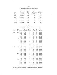
Temperatures <strong>of</strong> thermal waters range from mildly warm,<br />
at several points within the Grande Ronde Valley, to 180°F at<br />
Hot Lake. Thermal features include both water wells and springs.<br />
Thermal wells are abundant within Grande Ronde Valley, "t-7hereas<br />
thermal springs are found only in the southern part <strong>of</strong> the valley<br />
and farther south, towards Haines and at Medical Springs. The<br />
springs uniformly are at higher temperatures than the wells,<br />
although the latter penetrate to as much as 1,500 feet in depth.<br />
Gradients within wells commonly are 2° to 3°F per 100 feet;<br />
such gradients are not highly encouraging. Hm11ever, it must<br />
be noted that most <strong>of</strong> these wells intercept aquifers recharged<br />
by meteoric water, and therefore may be cooled by dilution.<br />
Along this line, concentrations <strong>of</strong> silica are as high,<br />
or even slightly higher, in wells <strong>of</strong> 80° and 84°F as in the<br />
highest temperature springs <strong>of</strong> the area, at up to 88 ppm SiOz<br />
(see Table 3a). There are no apparent sources <strong>of</strong> chalcedony<br />
or opal within the alluvial and mafic volcanic terrain; therefore,<br />
a quartz equilibrium may be present at depth. This<br />
suggests that, indeed, thermal waters ascend into aquifers at<br />
depths to 1,500 feet, and are cooled and/or diluted therein.<br />
The depth and composition <strong>of</strong> the thermal source are unknown.<br />
- 37 -
JAMES B. KOENIG (415) 524-9242<br />
MURRAY C. GARDNER (503) 482-2605<br />
Map<br />
No.<br />
2<br />
5<br />
7<br />
Table 3b.<br />
h<br />
TEMPERATURE DATA FROM WATER WELLS<br />
IN THE LA GRANDE - HOT LAKE AREA<br />
901 MENDOCINO AVE.<br />
Geot ermEx BERKELEY, cA. 94707<br />
(from well files in the <strong>of</strong>fice <strong>of</strong> the Oregon<br />
State Engineer and from Hampton and Brown,<br />
1964.)<br />
Drilled<br />
Well No. Owner Depth, ft. Temperature,<br />
1/39-20 "Clayton Fox Well" 1,468 81<br />
3/38-6Hl Union Pacific R.R. ? 77<br />
3/39-6H Weishaar 134 60<br />
- 39 -<br />
OF
JAMES B. KOENIG (415) 524-9242<br />
MURRAY C. GARDNER (503) 482-2605<br />
901 MENDOCINO AVE.<br />
Geotherm Ex BERKELEY. cA. 94707<br />
and possibly by crustal rifting and thinning. The mantle<br />
is brought closer to the earth's surface by the crustal<br />
thinning process, and the deeper crustal isotherms like\vise<br />
are brought closer to the surface. An economic geothermal<br />
source occurs where the uplifted isotherms are telescoped<br />
sufficiently, in the presence <strong>of</strong> large quantities <strong>of</strong> fluids,<br />
at drillable depths.<br />
Thinned crust, perhaps accompanied by convecting mass<br />
and bowed-up isotherms, may extend from the Vale, Oregon<br />
Weiser, Idaho region in a discontinuous manner to, and possibly<br />
beyond, Grande Ronde Valley. In such a case, the presence <strong>of</strong><br />
a discrete plutonic intrusion or a young eruptive center may<br />
<strong>of</strong>fer an obvious target for exploration, but is not the cause<br />
<strong>of</strong> the thermal anomaly. The relative shallowness to mantle<br />
is the source <strong>of</strong> heat.<br />
It must be recognized, <strong>of</strong> course, that neither hypothesis<br />
may provide a sufficiently intense, shallow and largescale<br />
source <strong>of</strong> heat to power a geothermal system <strong>of</strong> commercial<br />
significance. Data available to date are not conclusive. However,<br />
this prospect does not exhibit either the intensity or<br />
youthfulness <strong>of</strong> thermal phenomena farther to the southeast on<br />
the Snake River structure.<br />
Reservoir.<br />
Several lithologic units suggest themselves as potential<br />
geothermal reservoir rocks. Working downward through the<br />
stratigraphic column, the units are presented in the order they<br />
would be encountered by the drill bit.<br />
The platy andesite (Ta) is a compact, non-porous, impermeable<br />
rock that has been faulted and fractured. Although a<br />
few <strong>of</strong> the faults and several <strong>of</strong> the vertical joint systems may<br />
permit limited ground-water movement through the unit, the platy<br />
andesite probably acts as a major cap rock unit.<br />
The olivine basalt (Tob) is vesicular to compact, highly<br />
porous to non-porous, blocky to rubbly, but occasionally columnar<br />
jointed, and is probably highly permeable along thin horizons.<br />
This rock is a discontinuous aquifer, however, and this and the<br />
thinness <strong>of</strong> the unit may limit its potential as a geothermal<br />
reservoir.<br />
- 42 -
JAMES B. KOENIG (415) 524-9242<br />
MURRAY C. GARDNER (503) 482-2605<br />
901 MENDOCINO AVE.<br />
<strong>GeothermEx</strong> BERKELEY, cA. 94707<br />
geothermal target in this region. Beneath a section <strong>of</strong> Quaternary<br />
sediment approximately 1,700 feet in thickness, rocks<br />
correlative with Columbia River Basalt were encountered.<br />
Temperatures apparently were not high enough to encourage<br />
further drilling.<br />
Recharge.<br />
If a geothermal aquifer is sought in the Columbia River<br />
Basalt, storage capacity is likely to be great, and reserves <strong>of</strong><br />
fluid are not likely to become a problem. Recharge into the<br />
system probably occurs through coarser-grained fan deposits,<br />
river channel deposits, talus and colluvium, and along principal<br />
fault zones.<br />
Should the pre-Tertiary basement become the target for<br />
a geothermal reservoir, storage-capacity will become a major<br />
question. Recharge into basement may occur through overlying<br />
Tertiary volcanic and sedimentary rocks, through coarser-grained<br />
Quaternary sediments, or as direct infiltration into surface<br />
outcrops. In any case, faults and other fractures are likely<br />
to serve as recharge channels. These same features may constitute<br />
the principal reservoir, or at least serve as communication<br />
channels between more-heavily and less-heavily fractured lithologies<br />
in the basement.<br />
EXPLORATION PROGRAM<br />
As outlined above, the focus for further exploration<br />
will be a northeast-trending zone up to 6 miles in width at<br />
the south end <strong>of</strong> Grande Ronde Valley, where depth to basement<br />
is believed to be 3,000 to 5,000 feet. Exploration will have<br />
as principal goals the interpretation <strong>of</strong> structure, determination<br />
<strong>of</strong> depth to basement and location <strong>of</strong> aquifers in this<br />
target area.<br />
It is necessary to integrate the results <strong>of</strong> the 1974<br />
field exploration program into a coherent picture. This will<br />
require the reduction <strong>of</strong> gravity data to complete Bouguer<br />
anomalies, and the interrogation <strong>of</strong> gravity and magnetic data<br />
to provide information on:<br />
- 45 -
JAMES B. KOENIG (415) 524-9242<br />
MURRAY C. GARDNER (503) 482-2605<br />
901 MENDOCINO AVE.<br />
Geotherm Ex BERKELEY, cA. 94707<br />
1. structural patterns, including faults, especially<br />
beneath the cover <strong>of</strong> Quaternary sediment;<br />
2. depths to and shape <strong>of</strong> basement;<br />
3. possible presence <strong>of</strong> youthful intrusions within<br />
basement or overlying section <strong>of</strong> Tertiary and<br />
Quaternary materials.<br />
The hydrochemical data should be studied closely, and<br />
mixing models considered, such that the chemical nature and<br />
thermodynamic character <strong>of</strong> the reservoir fluid can be approximately<br />
known.<br />
Data from earlier passive seismic surveys should be<br />
reviewed, and compared with geologic maps and cross-sections<br />
and structural inferences obtained from magnetic and gravity<br />
data. After this had been done, it may be necessary to carry<br />
out additional gravity and/or magnetic surveys across the<br />
southern end <strong>of</strong> the project area, especially the southern part<br />
<strong>of</strong> Grande Ronde Valley and immediately to the south.<br />
It is expected that deep resistivity surveys, utilizing<br />
dipole mapping and deep sounding techniques, will become advisable.<br />
Electromagnetic soundings may replace or supplement large<br />
Schlumberger-equatorial expansions. These surveys may provide<br />
data on depth to and shape <strong>of</strong> basement, probable permeable zones<br />
and potential thermal aquifers. However, it may be worthwhile<br />
to perform an active seismic pr<strong>of</strong>iling survey. The extent and<br />
thickness <strong>of</strong> basalt flows and related mafic rocks may preclude<br />
such a survey, however.<br />
If geological and geophysical targets are recognized,<br />
the drilling <strong>of</strong> slim holes will be in order. These should<br />
be drilled deep enough to penetrate the principal regional<br />
aquifers, in order to avoid calculation <strong>of</strong> unrealistic temperature<br />
gradients. Individual holes may be reamed to greater<br />
width, and deepened, if data are encouraging.<br />
- 46 -
JAMES B. KOENIG (415) 524-9242<br />
MURRAY C. GARDNER (503) 482-2605<br />
SELECTED REFERENCES<br />
901 MENDOCINO AVE.<br />
<strong>GeothermEx</strong> BERKELEY. cA. 94707<br />
Beaulieu, J.D., 1972, Geological formations <strong>of</strong> Eastern Oregon,<br />
east <strong>of</strong> longitude 120° 30': Oregon Dept. Geol. and Min.<br />
Industries, Bull. 73, 80 p.<br />
Brooks, H. C., Mcintyre, J. R. and Walker, G. W., in preparation,<br />
Reconnaissance geologic map <strong>of</strong> the Baker quadrangle, Oregon<br />
and Idaho: to be issued as U.S. Geol. Survey Misc. Geol.<br />
Investigations map, 1:250,000 scale.<br />
Clark, T. H. and Stearn, C. W., 1968, Geological evolution <strong>of</strong><br />
North America: The Ronald Press Co., New York, 570 p.<br />
Ducret, G. L., Jr. and Anderson, D. B., 1965, Records <strong>of</strong> wells,<br />
water levels, and chemical quality <strong>of</strong> water in Baker Valley,<br />
Baker County, Oregon: Oregon State Engineer, Ground Water<br />
Report No. 6, 34 p.<br />
Gilluly, James, 1937, Geology and mineral resources <strong>of</strong> the Baker<br />
quadrangle, Oregon: U. S. Geol. Survey Bull. 879, 119 p.<br />
Hampton, E. R. and Brown, S. G., 1964, Geology and ground-water<br />
resources <strong>of</strong> the upper Grande Ronde River Basin, Union<br />
County, Oregon: U. S. Geol. Survey Water-supply Paper<br />
1597, 99 p.<br />
Koenig, J. B. and Gardner, M. C., 1973, La Grande- Hot Lake,<br />
Oregon; geothermal prospect, reconnaissance evaluation<br />
and work plan: private report to AMAX.<br />
Lystrom, D. J., Nees, W. L. and Hampton, E. R., 1967, Ground<br />
water <strong>of</strong> Baker Valley, Baker County, Oregon: U. S. Geol.<br />
Survey Hydrologic Investigations Atlas HA-242, map,<br />
scale 1:96,000.<br />
Mariner, R. H., Rapp, J. B., Willey, L. M. and Presser, T. S.,<br />
1974, The chemical composition and estimated minimum thermal<br />
reservoir temperatures <strong>of</strong> selected hot springs in Oregon:<br />
U.S. Geol. Survey Open File Report, 27 p.<br />
- 47 -
-----------------------------------------------------------<br />
JAMES B. KOENIG (415) 524-9242<br />
MURRAY C. GARDNER (503) 482-2605<br />
h<br />
901 MENDOCINO AVE.<br />
Geot erm Ex BERKELEY, cA. 94707<br />
Mcintyre, J. R., unpublished, Geology <strong>of</strong> the Haines, Hagpie<br />
Peak, Keating NW, and Sawtooth Ridge, Oregon, 7.5-minute<br />
quadrangles, scale 1:24,000: source materials for Brooks,<br />
Hclntyre, and Walker (in preparation).<br />
Newcomb, R. C., 1970, Tectonic structure <strong>of</strong> the main part <strong>of</strong><br />
the basalt <strong>of</strong> the Columbia River Group, Washington,<br />
Oregon, and Idaho: U.S. Geol. Survey Misc. Geol. Investigations<br />
Hap I-587, scale 1:500,000.<br />
Pardee, J. T., 1941, Preliminary geologic map <strong>of</strong> the Sumpter<br />
quadrangle, Oregon: Oregon Dept. Geol. and Hin. Industries<br />
map, scale 1:96,000.<br />
Patterson, P. V., 1969, Sa.o1tooth Ridge: a northeast Oregon<br />
volcanic center: Oregon Dept. Geol. and Hin. Industries:<br />
The Ore Bin, v. 31, no. 9, p. 173-183.<br />
Prostka, H. J., 1962, Geology <strong>of</strong> the Sparta quadrangle, Oregon:<br />
Oregon Dept. Geol. and Min. Industries map, scale 1:62,500.<br />
Prostka, H. J., 1963, Geology <strong>of</strong> the Sparta quadrangle, Oregon:<br />
Unpublished Ph.D. dissertation, JohnsHopkins <strong>University</strong>.<br />
Smith, R. B. and Sbar, H. L., 1974, Contemporary tectonics and<br />
seismicity <strong>of</strong> the western United States with emphasis on<br />
the intermountain seismic belt: Geol. Soc. Am. Bull.,<br />
v. 85, no. 8, p. 1205-1218.<br />
Smith, W. D. and Allen, J. E., 1941, Geology and physiography<br />
<strong>of</strong> the northern Wallowa Mountains, Oregon: Oregon Dept.<br />
Geol. and Min. Industries, Bull. 12, 65 p.<br />
Uppuluri, Venkato Rao, 1974, Prineville chemical type: a new<br />
basalt type in the Columbia River Group: Geol. Soc. Am.<br />
Bull., v. 85, no. 8, p. 1315-1318.<br />
Walker, G. W., 1973 a, Reconnaissance geologic map <strong>of</strong> the<br />
Pendleton quadrangle, Oregon and Washington: U.S. Geol.<br />
Survey Misc. Geol. Investigations Map I-727, scale 1:250,000.<br />
Walker, G. W., 1973 b, Contrasting compositions <strong>of</strong> the youngest<br />
Columbia River Basalt flows in Union and Wallowa Counties,<br />
northeastern Oregon: Geol. Soc. Am. Bull., v. 84, no. 2,<br />
p. 425-430.<br />
- 48 -
JAMES B. KOENIG (415) 524-9242<br />
MURRAY C. GARDNER (503) 482-2605<br />
901 MENDOCINO AVE.<br />
Geot ermEx BERKELEY, cA. 94707<br />
Walker, G. W., 1973 c, Preliminary geologic and tectonic maps<br />
<strong>of</strong> Oregon east <strong>of</strong> the 12lst meridian: U.S. Geol. Survey<br />
Mise. Field Studies Map MF-ll95, scale 1:500,000.<br />
Walker, G. W., in preparation, Reconnaissance geologic map <strong>of</strong><br />
the Grangeville quadrangle, Oregon and Idaho: to be issued<br />
as U.S. Geol. Survey Misc. Geol. Investigations map, scale<br />
1:250,000.<br />
Waters, A. C., 1961, Stratigraphic and lithologic variations<br />
in the Columbia River Basalt: Am. Jour. Sci., v. 259,<br />
p. 583-611.<br />
- 49 -<br />
h