Review of the Niland Geothermal Project Nov - University of Utah
Review of the Niland Geothermal Project Nov - University of Utah
Review of the Niland Geothermal Project Nov - University of Utah

Create successful ePaper yourself
Turn your PDF publications into a flip-book with our unique Google optimized e-Paper software.
, I<br />
GL03074<br />
UNIVERSITY OF UTAH RESEARCH INSTITUTE<br />
UURI<br />
EARTH SCIENCE LABORATORY<br />
391 CHIPETA WAY, SUITE C<br />
SALT LAKE CITY, UTAH 84108-1295<br />
TELEPHONE 801·524·3422<br />
MEt10RANDUM<br />
<strong>Nov</strong>ember 14, 1984<br />
TO:<br />
FROM:<br />
SUBJECT:<br />
W. R. Holman<br />
Marsha 11 Reed<br />
D. L. Nielson<br />
J. N. Moore<br />
<strong>Review</strong> <strong>of</strong> <strong>the</strong> <strong>Niland</strong> Geo<strong>the</strong>rmal <strong>Project</strong><br />
At your request we reviewed <strong>the</strong> geoscience data from <strong>the</strong> <strong>Niland</strong><br />
geo<strong>the</strong>rmal project in conjunction with <strong>the</strong> Geo<strong>the</strong>rmal Loan Guarantee<br />
Program.<br />
The purpose <strong>of</strong> our review was to identify any resource related<br />
obstacle to <strong>the</strong> production <strong>of</strong> 25 MW. This review was brought about by<br />
information received from <strong>the</strong> drilling <strong>of</strong> Britz #4 which proved to be cooler<br />
than o<strong>the</strong>r holes drilled in <strong>the</strong> field.<br />
On Thursday, <strong>Nov</strong>ember 1, we met with Bill Smith <strong>of</strong> Republic Geo<strong>the</strong>rmal,<br />
Inc. (RGI) and Gordon Austin <strong>of</strong> <strong>the</strong> Ralph M. Parson's Company at <strong>the</strong> <strong>of</strong>fices<br />
<strong>of</strong> RGI in Santa Fe Springs, California. They presented us with an overview <strong>of</strong><br />
<strong>the</strong> project to date. We were given copies <strong>of</strong> a summary report which Smith was<br />
preparing following <strong>the</strong> completion <strong>of</strong> <strong>the</strong> Britz #4 well.<br />
This report<br />
integrates <strong>the</strong> data from previous holes with that received from Britz #4.<br />
We<br />
were told that Britz #4 was drilled on <strong>the</strong> eastern portion <strong>of</strong> <strong>the</strong> property at<br />
DOE's request to test <strong>the</strong> limits <strong>of</strong> <strong>the</strong> field. The well was completed at 9570
feet. Attempts to flow <strong>the</strong> well were unsuccessful.<br />
During <strong>the</strong> drilling,<br />
approximately 200 feet <strong>of</strong> casing had unscrewed and followed <strong>the</strong> bit down <strong>the</strong><br />
hole. This section <strong>of</strong> casing became lodged at about 8000 feet, and was<br />
causing sufficient problems that <strong>the</strong> well was plugged back to 6500 feet in<br />
preparation for a side track. Due to <strong>the</strong> lower temperatures encountered in<br />
this hole, Fee #6 was spudded from <strong>the</strong> pad <strong>of</strong> Fee #5 and it will be<br />
directionally drilled to <strong>the</strong> west.<br />
On <strong>Nov</strong>ember 2, we returned to RGI for half <strong>the</strong> day to ga<strong>the</strong>r more information.<br />
We <strong>the</strong>n went to <strong>the</strong> campus <strong>of</strong> <strong>the</strong> <strong>University</strong> <strong>of</strong> California Riverside<br />
for discussions with Dr. Wilfred Elders and his colleagues. Since <strong>the</strong> time<br />
frame <strong>of</strong> <strong>the</strong> review was so short, we had to rely a great deal on what o<strong>the</strong>r<br />
people were telling us, and our conversations with Elders allowed us to verify<br />
conclusions presented to us by RGI and Parsons.<br />
In addition, in order to<br />
complete this review in <strong>the</strong> required time we had to focus on a few points.<br />
These were as follows.<br />
1. Is <strong>the</strong>re a <strong>the</strong>rmal barrier between Britz #3 and #4?<br />
2. Is <strong>the</strong> stratigraphic and structural picture reasonable?<br />
3. What controls <strong>the</strong> production <strong>of</strong> <strong>the</strong> geo<strong>the</strong>rmal fluids?<br />
4. What can <strong>the</strong> fluid chemistry tell us about <strong>the</strong> temperatures and <strong>the</strong><br />
origin <strong>of</strong> <strong>the</strong> geo<strong>the</strong>rmal fluids?<br />
5. Is <strong>the</strong> hydro<strong>the</strong>rmal alteration consistent with <strong>the</strong> reservoir model?<br />
These points are discussed in detail below.<br />
Thermal Regime<br />
The <strong>Niland</strong> Associates lease is located on <strong>the</strong> nor<strong>the</strong>ast side <strong>of</strong> <strong>the</strong><br />
Salton Sea geo<strong>the</strong>rmal temperature anomaly.<br />
Regional data demonstrates that<br />
<strong>the</strong> iso<strong>the</strong>rmal surfaces are dipping to <strong>the</strong> east in this area.<br />
It was <strong>the</strong>refore<br />
expected that holes on <strong>the</strong> eastern portion <strong>of</strong> <strong>the</strong> lease would be cooler
as a function <strong>of</strong> depth than holes on <strong>the</strong> western portion <strong>of</strong> <strong>the</strong> lease.<br />
Bottom<br />
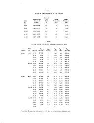
hole temperatures measured seven hours after circulation stopped in Britz #4<br />
reached 391°F and 411°F, ten hours after circulation. Since <strong>the</strong> hole was<br />
plugged, we can only estimate what <strong>the</strong> bottom hole temperature would have been<br />
had <strong>the</strong> hole had time to equilibrate. Figure 1 shows <strong>the</strong> temperature vs time<br />
at two points in Britz #3; both depths showed an increase <strong>of</strong> 121°F from<br />
shortly after circulation to equilibration three years later. Of course many<br />
factors will influence <strong>the</strong> amount and speed <strong>of</strong> temperature increase, but if we<br />
accept 120°F as a good estimate <strong>the</strong>n Britz #4 should reach a bottom hole<br />
equilibration temperature <strong>of</strong> 510°F. This is about 30°F lower than is<br />
predicted by extrapolating <strong>the</strong> regional iso<strong>the</strong>rms. From this we conclude that<br />
<strong>the</strong> iso<strong>the</strong>rms are dipping to <strong>the</strong> east as predicted, but <strong>the</strong>re are no major<br />
<strong>the</strong>rmal barriers that will affect <strong>the</strong> success <strong>of</strong> <strong>the</strong> project. Wells in this<br />
area have to be deeper to intersect- <strong>the</strong> producing horizons.<br />
Stratigraphy and Structure<br />
The subsurface stratigraphy <strong>of</strong> <strong>the</strong> area is principally interpreted<br />
through <strong>the</strong> use <strong>of</strong> electrical logs. We looked at RGI's picks and <strong>the</strong>y appear<br />
to be reasonable. Elders intends to lithologically log <strong>the</strong>se holes and<br />
correlate <strong>the</strong> data with <strong>the</strong> electric logs to form a stratigraphic framework,<br />
but that task is outside his present interest in nuclear waste analogs. Given<br />
<strong>the</strong> stratigraphic picture, <strong>the</strong> structural interpretations presented by RGI are<br />
also quite reasonable.<br />
Production Controls<br />
Production is apparently controlled by fracturing which crosses lithologic<br />
boundaries. The fracturing appears to be related to <strong>the</strong> degree <strong>of</strong><br />
alteration, and is best detected by cycle skipping on borehole sonic logs.
600<br />
.n----------~ (6T =121)<br />
~--------......,t-l.(6 T =121)<br />
~ 500<br />
o<br />
300<br />
.6. - BRITZ ** 3 9400' Measured (-8800 Vert. depth)<br />
o -BRITZ #3 10.000' (,--9250 Vert.depth)<br />
o -BRITZ #4 9570' ("'9500 Vert. depth)<br />
HOURS FOLLOWING CIRCULATION<br />
FIGURE 1
, ,<br />
Britz #4 was only about 100 feet into this zone <strong>of</strong> fracturing when drilling<br />
stopped.<br />
Fluid Chemistry<br />
The chemistry <strong>of</strong> <strong>the</strong> hydro<strong>the</strong>rmal fluids has been examined in detail by<br />
Don Michels <strong>of</strong> RGI. Fee #1 and #5 produce hypersaline brines characterized by<br />
a total dissolved solids (TDS) content <strong>of</strong> approximately 250,000 ppm. In<br />
contrast, <strong>the</strong> fluid discharged from Britz #3 is less saline, having a TDS<br />
content <strong>of</strong> 138,000 ppm.<br />
Michels has suggested that this moderately saline water does not represent<br />
an independent fluid type but is instead a mixture <strong>of</strong> <strong>the</strong> hypersaline<br />
brine with a second, less saline fluid. His calculations indicate that this<br />
second fluid must have a TDS near 70,000 ppm. Fur<strong>the</strong>rmore, it can be shown<br />
that <strong>the</strong> lower salinity fluid must be less dense, and <strong>the</strong>refore lie above <strong>the</strong><br />
hypersaline brines.<br />
The presence <strong>of</strong> two fluids with different salinities is supported by<br />
fluid inclusion data from Fee #1. Low salinity fluid inclusions occur in<br />
paleoaquifers at depths <strong>of</strong> 6000 and 10,000 feet, whereas inclusions containing<br />
hypersaline brines occur at a depth <strong>of</strong> about 9000 feet. Heating measurements<br />
indicate that <strong>the</strong> high salinity fluids had a temperature <strong>of</strong> 572°C, whereas <strong>the</strong><br />
lower salinity brines occurring at 10,000 feet had a temperature <strong>of</strong> about<br />
563°C.<br />
These data are generally consistent with <strong>the</strong> present temperatures and<br />
indicate that <strong>the</strong> boundary between <strong>the</strong> brines has not remained stationary with<br />
time.<br />
Britz #4 produced a fluid slightly less saline than <strong>the</strong> fluid from Britz<br />
#3. This fluid has a TDS content <strong>of</strong> approximately 80,000 ppm. Although <strong>the</strong><br />
fluid was contaminated with drilling mud, <strong>the</strong> relatively high metal contents<br />
suggest that <strong>the</strong> fluid is a mixture <strong>of</strong> <strong>the</strong> hypersaline brine and lower
salinity fluids. The hypersaline fluid may have entered <strong>the</strong> well near its<br />
base where <strong>the</strong> sonic logs indicate an increase in fracturing. The presence <strong>of</strong><br />
hypersaline brine in Britz #4 argues that <strong>the</strong> poor productivity <strong>of</strong> this well<br />
is more a reflection <strong>of</strong> its failure to intersect permeable fractures than to<br />
any fundamental changes in <strong>the</strong> reservoir. Drilling to deeper depths appears<br />
to be warranted in this area <strong>of</strong> <strong>the</strong> field.<br />
Hydro<strong>the</strong>rmal Alteration<br />
The hydro<strong>the</strong>rmal mineralogy <strong>of</strong> <strong>the</strong> <strong>Niland</strong> wells is being studied by<br />
scientists at <strong>the</strong> <strong>University</strong> <strong>of</strong> California at Riverside.<br />
The mineralogy <strong>of</strong><br />
Fee #1 and #5 and Britz #3 have been established from X-ray analysis <strong>of</strong> <strong>the</strong><br />
cuttings and by some thin section work. Chlorite is <strong>the</strong> dominant hydro<strong>the</strong>rmal<br />
mineral in <strong>the</strong> wells first occurring in quantities greater than 5% at 4000<br />
feet in Fee #1 and at 6000 feet in Britz #3. All <strong>of</strong> <strong>the</strong> production in Fee #1<br />
and Britz #3 occurs at least several thousand feet beneath <strong>the</strong> top <strong>of</strong> <strong>the</strong><br />
chlorite zone. At <strong>the</strong>se metamorphic grades, permeability will probably be<br />
controlled by fractures.<br />
Chlorite typically marks <strong>the</strong> onset <strong>of</strong> high temperature alteration in <strong>the</strong><br />
Imperial Valley, becoming abundant only at temperatures above about 180°C.<br />
The top <strong>of</strong> <strong>the</strong> chlorite zone in <strong>the</strong> two wells thus defines a south-eastward<br />
dipping surface that appears to be generally formable with <strong>the</strong> present<br />
temperature distributions in <strong>the</strong> wells.<br />
The hydro<strong>the</strong>nnal mineralogy <strong>of</strong> <strong>the</strong><br />
<strong>Niland</strong> wells differs in two respects from <strong>the</strong> more "usual" alteration<br />
assemblages which characterize <strong>the</strong> high temperature fields <strong>of</strong> <strong>the</strong> Imperial<br />
Valley. Despite <strong>the</strong> relatively high temperatures at <strong>Niland</strong>, epidote and base<br />
metal sulfides are absent from <strong>the</strong> altered rocks. The lack <strong>of</strong> epidote may<br />
reflect relatively high CO 2 contents in <strong>the</strong> reservoir; <strong>the</strong> reason for <strong>the</strong><br />
absence <strong>of</strong> sulfides (o<strong>the</strong>r than pyrite) is less clear.
Conclusions<br />
The results <strong>of</strong> our review were reported at a meeting in <strong>the</strong> <strong>of</strong>fices <strong>of</strong><br />
BGI in Berkeley on <strong>Nov</strong>ember 3. These conclusions were also phoned to Marshall<br />
Reed following our meeting.<br />
Our review found that <strong>the</strong> results <strong>of</strong> Britz #4 do not change <strong>the</strong> resource<br />
model for <strong>the</strong> <strong>Niland</strong> field. The resource was known to have been deeper in <strong>the</strong><br />
vicinity <strong>of</strong> Britz #4 and its failure to encounter significant fluid production<br />
results from <strong>the</strong> relatively shallow depth <strong>of</strong> <strong>the</strong> well. Evidence shows that<br />
had <strong>the</strong> hole been allowed to come to equilibrium, temperatures would be in<br />
line with those previously predicted.