(iL0l50^ - University of Utah
(iL0l50^ - University of Utah
(iL0l50^ - University of Utah

You also want an ePaper? Increase the reach of your titles
YUMPU automatically turns print PDFs into web optimized ePapers that Google loves.
••• \<br />
(<strong>iL0l50^</strong><br />
MINERAL DEPOSITS AND GEOLOGY OF NORTHERN OMAN AS OF 1974<br />
By R. G. Coleraan and E. H. Bailey<br />
U. S. Geological Survey<br />
Open-File Report 81 - /-^Sy<br />
This report is preliminary and has not been<br />
reviewed for confornjity with U. S. Geological<br />
Survey editorial standards and stratigraphic<br />
nomenclature. Any use <strong>of</strong> trade names is for<br />
descriptive purposes only and does not imply<br />
endorsement bv the USGS.<br />
Pr'ep'ar'e-.'. oia 'behalf <strong>of</strong> the Directorate Genera], <strong>of</strong> Petroleum and Minerals,<br />
•Ministry <strong>of</strong> Development, Sultanate <strong>of</strong> Oman.<br />
1931
Frontispiece. Headquarters building <strong>of</strong> the Directorate <strong>of</strong> Petroleum<br />
and Minerals, Ministry <strong>of</strong> Development, Muscat, Sultanate <strong>of</strong> Oman.
CONTENTS<br />
Page<br />
Suiiunary 1<br />
Introduction la<br />
Staff la<br />
Methods <strong>of</strong> investigation and logistics. la<br />
-Acknowledgements .....: 3<br />
Geography. 3<br />
(Oology. 5<br />
Previous work ;........ 5<br />
Geologic overview 9<br />
Basement rocks (Autochthon) 10<br />
Pre-Permian rocks 10<br />
.Arabian Shelf Carbonates....... 10<br />
Ophiolite and related rocks (Allochthon) 10<br />
Semail ophiolite 10<br />
Hawasina unit, exotics, melange, and metamorphics 14<br />
Sedimentary rocks lying on Semail ophiolite 18<br />
Shallow-water marine limestone ',.... 13<br />
Pliocene-Holocene deposits.. • ••• 18<br />
Structural history 19<br />
Economic geology—metallic minerals . 21<br />
Summary -1<br />
Copper deposits <strong>of</strong> the Semail ophiolite. I'i<br />
Dfescriptions <strong>of</strong> copper deposits in volcanic rocks 30<br />
•-(1) Semda 30<br />
(2) Lushil.. '. 33<br />
(3) Zabin. 36<br />
(4) Fizh .. 39<br />
yS) Khabiyat .. 39<br />
c (6) Bayda. 42<br />
0 (7) Aarja 45<br />
(8) Ghayth 48<br />
^^ (9) Usail ..., 51<br />
(10) Jabah. 54<br />
(11) Rakah 54<br />
Descriptions <strong>of</strong> copper deposits in gabbro and peridotite. 58<br />
(12) Maydan I.. .*... '. . . 58<br />
(13) Maydan II. . .... 58<br />
(14) Bu Kathir 58<br />
(15) Hawirdit... 62<br />
(16) Tawi Ubaylah.' 62<br />
(17) Ghayl.. 65<br />
(18) Muden 65<br />
(19)'L-azak 65<br />
(20) Tabakhat '. 66<br />
(21) Khafifah .......; 69<br />
(22) .Masakivah.. 69<br />
II
- . Page<br />
(23) Inah ... 69<br />
(24) Eedah I. 69<br />
(25) Eedah il... .., " 70<br />
(26) Hoowasi 70<br />
(27) Khara.,-. 71<br />
(28) Zahir. 71<br />
(29) Shwayi. 72<br />
Iron and nickel(?) deposits in laterite 75'<br />
Summary. 75<br />
Descriptions <strong>of</strong> laterice deposits... .^ ... .^.. 77<br />
(30,31) Kalahay Niba I and II 77<br />
(32) Salahc 77<br />
(33) Wasic... 81<br />
(34) Fanjah ,. 81<br />
(Jhromlte deposits in Semail peridotite 83<br />
Descriptions <strong>of</strong> chromite deposits 85<br />
(35) Maaakirah 85<br />
(36) Mudi 85<br />
(37) Aka Keya 85<br />
Manganese deposits in Hawasina chert 88<br />
Descriptions <strong>of</strong> manganese deposits 88<br />
(38) Hammah. .. . 88<br />
(39) Jaramah . 88<br />
(40) Wasit 92<br />
Lead-zinc deposit 93<br />
(41) Nujum ,. 93<br />
Economic geology—nonmetallic minerals . 96<br />
Limestone-dolomite. 96<br />
Asbestos 96<br />
Magnesite 96<br />
Clay 98<br />
Evaporites 98<br />
Hot springs 98<br />
Descriptions <strong>of</strong> hot springs 99<br />
(42) Gallah 99<br />
(43) Rustag... 99<br />
(44) Al Khadra 99<br />
Cold springs 101<br />
Reconmendations 1 1^',<br />
\j-*<br />
Metallic ore deposits. J 105<br />
Nonmetallic ore deposits 10<br />
Water Resources .- 108<br />
Mapping. 109<br />
Open-aoor science policy .and Arab cocperation. 112<br />
Selected references 113<br />
Appendix 117<br />
III<br />
r<br />
1/
: -LIST OF FIGURES .<br />
Page<br />
Figure i. Hap <strong>of</strong> Oman showing published geologic maps by 1974<br />
and proposed mapping.... ^<br />
2. Map <strong>of</strong> Oman showing area covered by gravity surveys<br />
through 1973 .....' 7<br />
3. Map <strong>of</strong> Oman showing area covered by aeroraagnetic<br />
surveys through 1973. ,. 8<br />
4. ERTS mosaic <strong>of</strong> northern Oman at 1:500,000 scale,<br />
showing locations <strong>of</strong> mineral deposits and hot<br />
springs. Deposits are numbered as in text and<br />
on Table; 1. Also shown on mosaic is the UTM<br />
grid by which the location <strong>of</strong> deposits is given in<br />
the text .....4.. In. pocket<br />
5. Diagram showing distribution <strong>of</strong> 29 copper-iron<br />
sulfide deposits in the Semail ophiolite. 25<br />
6. Geologic map <strong>of</strong> the "Bowling Alley" showing the<br />
relation <strong>of</strong> copper-iron sulfide deposits to .<br />
northwest-trending faults 29<br />
\ .<br />
7. Geologic map <strong>of</strong> the Semda copper deposit. 32.<br />
8. Geologic map <strong>of</strong>. the Lushil deposit, . 34<br />
9. . Geologic .map <strong>of</strong> the Zabin deposit.. .. 3%<br />
10. Geologic map <strong>of</strong> the Fizh deposit 40<br />
11. Geologic map cf the Bayda copper deposit...... 43<br />
12. .Geologic map <strong>of</strong> the Aarja copper deposit .w..... 46<br />
.13. Geologic map <strong>of</strong> the Ghayth deposit 49<br />
14. Geiologic tnap <strong>of</strong> the Rakah copper deposit 55<br />
15. Geologic map <strong>of</strong> the .Maydan I copper deposit 59<br />
16. Geologic.map <strong>of</strong> the Maydan II copper deposit. 60<br />
17. Geologic map <strong>of</strong> the Hawirdit copper deposit. .!. 63<br />
18. Sketch map <strong>of</strong>'one <strong>of</strong> the underground workings at the<br />
Tabakhat copper deposit. 67<br />
IV
LIST OF FIGURES—Continued<br />
Figure 19. Geologic map'<strong>of</strong> the Shwayi copper deposit<br />
Page<br />
73<br />
20. Sketch map showing area <strong>of</strong> potential iron deposits in<br />
lateritei 76<br />
21. Map showing locations <strong>of</strong> the Kalahay Niba iron deposits<br />
in latetite below Tertiary limestone 80<br />
22. Map showing location and geologic setting <strong>of</strong> the<br />
Masakirah chromite deposit.... 86<br />
23. Measured section through one <strong>of</strong> the ore zones <strong>of</strong> the<br />
Jaramah manganese deposit near Ras al Hadd 90
LIST OF PHOTOS<br />
Frontispiece. Headquarters building <strong>of</strong> the Directorate <strong>of</strong><br />
Petroleum and Minerals, Muscat, Oman. Page<br />
Photo 1. Land Rover caravan <strong>of</strong> U.S.G.S. team...... 2<br />
2. Folded flanks <strong>of</strong> Jabal Akhdar showing Arabian Shelf<br />
carbonates and overlying Hawasina chert, limestone,<br />
and melange. • 11<br />
3. Hawasina melange in "Bowling Alley" 12<br />
4. Semail peridotite in mountains and calcium hydroxide<br />
spring 13<br />
5. Layered gabbro in Semail ophiolite 15<br />
6. Diabase dike swarm in Semail ophiolite, 16<br />
7. Pillow lavas in upper part <strong>of</strong> Semail ophiolite, 17<br />
8. Semda gossan, showing depression due to collapse<br />
owing to removal <strong>of</strong> copper and iron in solution.... 3d<br />
9. Exposure <strong>of</strong> Lushil gossan 35<br />
10. Zabin deposit viewed looking northwest...... 3 7<br />
11. Gossan hills <strong>of</strong> the Wadi Fizh deposit., 41<br />
12. Bayda copper deposit 44<br />
13. Aarja copper deposit 47<br />
14. Ghayth gossan zone 50<br />
15. Lasail copper deposit as viewed from the air showing<br />
surrounding ancient slag piles ... 52<br />
16. Central part <strong>of</strong> gossan over the Lasail ore body...... 53<br />
17. Rakah gossan zone viewed from the air 56<br />
18. Northern part <strong>of</strong> the Ri-kah gossan zone 57<br />
VI
LIST OF PHOTOS—Continued<br />
Page<br />
Photo 19. .Maydan II ore zone • 61<br />
20. Mineralized shear zone <strong>of</strong> the Tawi Ubaylah copper<br />
deposit...... • 64<br />
21. Peridotite hillside containing underground workings<br />
<strong>of</strong> the Tabakhat copper mine 68<br />
22. Depression overlying the northern ore body <strong>of</strong> the<br />
Shwayi copper deposit • • • • '^<br />
23. Kalahay Niba I iron laterite deposit exposed under<br />
Tertiary "limestone 78<br />
24. Pisolitic iron ore at Kalahay Niba I deposit 79<br />
25. Aka Keya chromite deposit in Semail dunite 87<br />
26. Black chert containing pyrolusite in the Hawasina<br />
Unit at the Jaramah manganese deposit 89<br />
27. Ancient workings along the vein <strong>of</strong> the. Nujum<br />
lead-zinc deposit • •. 94<br />
28. Magnesite vein cutting serpentinized peridotite north<br />
<strong>of</strong> Rustag 97<br />
29. Khafifah calcium hydroxide spring, travertine, and<br />
stream mortar beds. , 103<br />
VII
List <strong>of</strong> Tables<br />
Table 1. List cf deposits investigated in northern Oman 22<br />
Page<br />
Table 2. Chemical analyses <strong>of</strong> chromites from Oman and<br />
, Trucial Oman 84<br />
Table 3. Chemical and spectrographic analyses <strong>of</strong><br />
manganese samples from the Hawasina Unit..., 91<br />
Table 4. Chemical analyses <strong>of</strong> Oman hot springs,<br />
concentrations in mg/1. 100<br />
Table 5. Chemical analyses <strong>of</strong> Oman calcium hydroxide<br />
spring waters concentrations in mg/1. 102<br />
Table 6. Chemical and spectrographic analyses <strong>of</strong> copper<br />
prospects in Semail Ophiolite 118<br />
Table 7. Spectrographic analyses <strong>of</strong> ancient sla.g from<br />
Oman copper deposits 122<br />
Table 8. Chemical and spectrographic analyses <strong>of</strong><br />
Kalahay Niba I and II iron deposits 123<br />
Table 9. Chemical and spectrographic analyses <strong>of</strong> iron<br />
laterite samples from Semail Ophiolite 124<br />
Table 10. Chemical and spectrographic analyses <strong>of</strong> Chromites<br />
from Semail Ophiolite, 125<br />
Table 11. Chemical and spectrographic analyses <strong>of</strong> Nujum<br />
lead-zinc depfosit 126<br />
Table 12;. Chemical and spectrographic analyses <strong>of</strong><br />
miscellaneous samples from northern Oman 127<br />
VIII
MINERAL DEPOSLTS AND GEOLOGY OF NORTHERN OMAN AS OF 1974<br />
. by •<br />
R. G. Coleman and E. H. Bailey<br />
SUMMARY<br />
An investigation <strong>of</strong> the mineral resources <strong>of</strong> northern Oman was<br />
carried out under an agreement between the U. S. Geological Survey<br />
and the Ministry <strong>of</strong> Development, Sultanate <strong>of</strong> Oman, during late 1973<br />
and early 1974. The purpose <strong>of</strong> the investigation was to provide an<br />
evaluation <strong>of</strong> the mineral potential <strong>of</strong> northern Oman and produce<br />
recoiranendations- leading toward the utilization <strong>of</strong> any viable mineral<br />
deposits that were found. The widespread copper deposits located<br />
within the Semail volcanics. appear to be mineable, the ironnickel<br />
laterites developed upon the weathered surface <strong>of</strong> the Semail<br />
ophiolite have economic potential. Manganese and chromite deposits<br />
investigated have only a marginal value and are not likely to be <strong>of</strong><br />
economic importance in the near future. Discovery <strong>of</strong> economic copper<br />
and iroq deposits warrants further geologic mapping and mineral<br />
exploration in northern Oman. In addition to this, recommendations<br />
regarding the organization <strong>of</strong> a geological and minif;g group within<br />
the Directorate <strong>of</strong> Petroleum and Minerals are presented.
' INTRODUCTION<br />
Negotiations for this investigation were initiated early in 1971<br />
by the Government <strong>of</strong> Oman in discussions with the U, S. Department <strong>of</strong><br />
State, and the final agreement was made in May 1973. The agreement<br />
provided that a U. S. Geological Survey team would carry out field<br />
investigations during the winter field season <strong>of</strong> 1973-1974 and would<br />
produce a written report within six months <strong>of</strong> the completion <strong>of</strong> the<br />
field work. This is the report so specified.<br />
Staff<br />
The U. S, Geological Survey team consisted pf Dr. R. G. Coleman<br />
and Dr. E. H. Bailey. Dr. Coleman conducted the initial planning and<br />
logistics <strong>of</strong> the operation beginning early in 1973 while in Menlo<br />
Park, California. In late November 1973, Dr. Coleman arrived in Oman<br />
and remained there until the end <strong>of</strong> February 1974. Dr. Bailey reached<br />
Oman on January 15, 1974 and remained until February 23, 1974. The<br />
U.S.G.S. team spent 125 man-days in Oman with 90 man-days in the field.<br />
Writing, typing, drafting, and chemical analyses for the final report<br />
entailed at least another 100 man-days during the period May-July<br />
1974. Dr.,G. F. Brown <strong>of</strong> the U.S.G.S. also contributed considerable<br />
time to the early phases <strong>of</strong> planning and organizing the Oman Project.<br />
Our field work was facilitated by assistance given to us by<br />
Mr. Mohammed Kasim <strong>of</strong> the Directorate <strong>of</strong> Petroleum and Minerals, and<br />
by Dr. Ismail El Boushi, Geologic Advisor to the Directorate,<br />
Methods <strong>of</strong> Investigation and Lo;^istics<br />
To assess the mineral potential <strong>of</strong> Oman it was necessary to.<br />
investigate the known ore occurrences and co also search for unrecorded<br />
deposits. In addition, time had to be spent doing reconnaissance<br />
mapping to learn the geologic relations where mineral deposits<br />
were known in order to appraise what other areas were also favorable<br />
for the discovery <strong>of</strong> new deposits. The most expeditious way to do<br />
this was to work out <strong>of</strong> field camps, examining known deposits, mapping<br />
the terrain within a limited distance from each camp, and inquiring<br />
<strong>of</strong> the local inhabitants and wali's about the occurrence <strong>of</strong> ancient<br />
mines or slag piles. We were assisted by .Mr. Salim Makki, Director<br />
•General <strong>of</strong> Petroleum and Minerals, in these contacts with the local<br />
wall's and the Omani people. These contacts provided valuable<br />
information regarding sites <strong>of</strong> ancient mines and possible areas <strong>of</strong><br />
.mineral deposits.<br />
The Directorate provided us with three Land Rover vehicles<br />
(two staition wagons, and one p\':k-up), a driver-interpreter, a cook, j<br />
and a watchman (photo I). Most <strong>of</strong> our camping equipment was sent to<br />
Oman by the U.S.G.S.; however, some essential items were loaned to us ;<br />
by the Directorate. In making our field examination.s approximately i<br />
la
i>iiii|Uiin»j^f),»i
I<br />
.'•Hfi<br />
8000 km (5000 miles)- were covered by Land Rover traverse, and<br />
although no mileage figure was kept <strong>of</strong> traverses on foot, the distance<br />
probably was in excess <strong>of</strong> 160 km (100 miles). In addition, we<br />
had approximately four hours <strong>of</strong> helicopter time through the courtesy<br />
<strong>of</strong> Prospection Limited.<br />
Two series <strong>of</strong> maps that cover Oman were available, one at<br />
1:500,000 and the other at 1:100,000, printed and distributed by the<br />
Ministry <strong>of</strong> Defense, United Kingdom. We also were provided with<br />
approximately 1000 RAF*aerial photographs (1:60,000) <strong>of</strong> the Oman<br />
Mountains through the Directorate <strong>of</strong> Military Surveys, Ministry <strong>of</strong><br />
Defense, United Kingdom. Our field observations were recorded on<br />
1:60,000 RAF photos, 1:100,000 maps, and on larger scale sKetch maps<br />
we made ourselves. Rock and ore samples were collected from selected<br />
areas, and some <strong>of</strong> these materials were chemically analyzed in order<br />
to ascertain the amount <strong>of</strong> economic metals contained. Basic to such<br />
an inyestigatipn is the acquisition <strong>of</strong> as much data as possible from<br />
previous geologic studies. In this we were particularly fortunate<br />
to have had the full cooperation <strong>of</strong> the Petroleum Development Company<br />
(OMAN) Ltd. (PDO) , which has done most <strong>of</strong> the; geologic mapping in Oman.<br />
Their maps were made available to us during our investigations.<br />
Ack nowled^ements<br />
We are indebted to Mr. Salim Makki, Direccor General <strong>of</strong> Petroleum<br />
and Minerals, for the support and cooperation he freely provided. Dr.<br />
Rudy JackLi, General Manager, PDO, generously provided us with much<br />
valuable unpublished geologic and geophysical data, and other members <strong>of</strong><br />
the Ppp staff also helped with our geologic wcrk on numerous occasions.<br />
Mr.C.C. Huston and Mr, Alan Hutchinson <strong>of</strong> Prospection Limited kindly<br />
provided us with information on cheir operation as well as a copy <strong>of</strong><br />
their 1973 field investigations report. Mr. C. J. Quinlan and Mr. Fred<br />
McEldowney <strong>of</strong> the American Embassy in Muscat '.vere a great help to us in<br />
establishinj our field project in Oman. Mr. J.3. Townsend, Economic<br />
Advisor to the Oman Government, provided encouragement and also greatly<br />
facilitated our operation in Oman.<br />
• ',••;. GEOGRAPHY-<br />
The area covered in this agreement is wholly within northern Oman<br />
and extends from Ras Al Hadd to the southern border <strong>of</strong> the Union <strong>of</strong><br />
Arab Emirates, an area <strong>of</strong> about 41,000 sq.'k.v, (16,000 sq. miles). Most<br />
<strong>of</strong> the area is within the Oman Mountains, which form a crescent shaped<br />
range extending 600 km (360 mil) parallel to the coast from Muscat to.<br />
the northern tip <strong>of</strong> the Musandam Peninsula. Northwest <strong>of</strong> Muscat, a<br />
narrow coastal plain 10-40 km (6-24 miles) wide, known as the Batinah,<br />
separates the mountains from the Gulf <strong>of</strong> Oman, but to the east <strong>of</strong><br />
Muscat the coastal plain disappears and farther southeastward to<br />
Ras Al Hadd the coast is rugged and 3tee? wit.i some parts drowned to<br />
form in intricate shoreline. The Oman Mountains form a barrier<br />
befrfeen the Batinah coast and the western interior <strong>of</strong> Oman. The<br />
* ?.oyal Air Force '
highest part is in the mid-section <strong>of</strong> the mountains at Jabal Akhdar,<br />
which rises to 2980 meters (9800 feet). Northward from Jabal Akhdar<br />
the mountains become subdued, and in the United Emirates section the<br />
average elevation in the mountains is less than 900 meters (2970<br />
feet). Continuing northward to the Musandam Peninsula the elevations<br />
rise to over 2000 meters (6600 feet) at Ruus Al Jibal. South <strong>of</strong><br />
Jabal Akhdar the mountain range is cleft by the Semail Gap providing a<br />
natural passageway across the Oman Mountains. The mountains to the<br />
south (Al Hajar Ash Shargi) are extremely rugged with many elevations<br />
in excess <strong>of</strong> 2000 meters (6600 feet).<br />
The Oman Mountains are dissected by numerous vadles that form deep<br />
canyons cutting into the core <strong>of</strong> the mountain range. The wadies<br />
flowing northeastward into the Gulf <strong>of</strong> Oman are steeper than those<br />
wadies flowing south into the great Interior basin (Umm as Samim) at<br />
the edge <strong>of</strong> the empty quarter (Rub Al Khali) and have locally<br />
advanced their headwaters southwestward beyond the crest <strong>of</strong> the range.<br />
The southwestern foothills <strong>of</strong> the Oman Mountains are marked by an almost<br />
continuous pediment that forms extensive gravel plains cut only<br />
locally by southwestem flowing wadies. South and east <strong>of</strong> the Oman<br />
Mountains the Wahiba sands cover the southwestern slope and only a<br />
narrow plain separates the mountains from the migrating sand dunes.<br />
' , . ' • ' ' \ '<br />
The positions <strong>of</strong> the main road syst;ems <strong>of</strong> Oman are strongly<br />
influenced by the physiography. .-Uong the Coastal Plain a new paved<br />
road extends northward from Muscat to Sohar allowing easy access Co<br />
all coastal towns, but south <strong>of</strong> Muscat there is no coastal road nor,is<br />
there any road crossing the kl Hajar Ash. Shargi. The main access road<br />
to the interior is a graded gravel road across the mountains at Semail.<br />
Gap. North <strong>of</strong> the Semail Gap road only two poor roads cross the Oman<br />
Mountains: 1) Wadi Jizzi from Sohar to Buraimi; 2) Wadies Zallah<br />
and Hawasina from Al Khabura to Ibri. The inaccessibility <strong>of</strong> much <strong>of</strong><br />
the Oman Mountains by road makes geologic work time consuming when<br />
carried out by Land Rover and foot traverses, and access is particularly<br />
difficult on the northeastern slope <strong>of</strong> the Oman.Mountains<br />
where incised wadies produce deep canyons that cannot be traversed<br />
by Land Rover. Because the accessibility <strong>of</strong> many parts <strong>of</strong> the Oman<br />
Mountains' is so difficult, large areas remain unexplored geologically,<br />
and this fact should be taken into account when making an evaluation<br />
<strong>of</strong> their mineraFpotential.<br />
The most important copper district <strong>of</strong> northern Oman has been,<br />
called the "Bowling Alley" by Prospection Ltd. (see photo 3 and<br />
figure 6) as it forms a narrow corridor (3 km x 17 km) on the east<br />
side <strong>of</strong>.the Oman mcuntains approximately 32 km due east <strong>of</strong> Sohar.
^ ^^ .,.,.. .,.^, .,..„., , . -, ^ , —,.-_-^,- ••»ii»iii«M;iMjiKWWjg'''''-'°'«««fqsM<br />
. .^ GEOLOGY<br />
Previous Work<br />
Geologic studies <strong>of</strong> northern Oman have been directed mainly<br />
toward the search for petroleum and reflect that Influence. A3 a<br />
proper background for this report a short review <strong>of</strong> previous work<br />
is presented. The earliest geologic report on Oman was made by<br />
Pilgrim (1908) as part <strong>of</strong> a larger study <strong>of</strong> the Persian Gulf area for<br />
the Geological Survey <strong>of</strong> India. Pilgrim's report was mostly descriptive<br />
and provided few details. During the winter field season <strong>of</strong><br />
1924-1925, G. M. Lees (1928a) carried out an extensive exploration<br />
<strong>of</strong> northern Oman and the southeastern coast, and his observations<br />
form the basis for some <strong>of</strong> the stratigraphic nomenclature now used.<br />
Nearly 25 years later. Increased interest in the petroleum potential<br />
<strong>of</strong> the Arabian peninsula brouRht forth a series <strong>of</strong> sumoiary papers on<br />
Oman geology: Hudson, Browms and Chatton (1954), Hudson, McGugan, and<br />
Morton (1954), Morton (1959), Hudson and Chatton (1959), Hudson (1960),<br />
and Tschopp Q.967a). Much <strong>of</strong> this data was a distillation <strong>of</strong> work carried<br />
out by oil companies, and very little basic data was published. The first<br />
published geologic map <strong>of</strong> Oman, at the scale <strong>of</strong> 1:2,000,000 resulted from<br />
a joint effort <strong>of</strong> the U. S. Geological Survey and Arabian .American Oil<br />
Company (1963). ^'.<br />
More recently Shell Research N.V.,^The Hague, and the Petroleum<br />
Development (Oman) Ltd. have carried out extensive geological studies<br />
<strong>of</strong> Oman, and summary reports have been published .by Wilson (1969),<br />
Glennie and others (1973), and Reinhardt (1969). A summary detailed<br />
report, including a geological map (1:500,000) <strong>of</strong> northern Oman<br />
wilt fct published in the near futu-re (Glenhie and others, 1974,<br />
Konink. Nederlandsch Geol. Mijnboukundig Genootschap Verh.). Besides<br />
these reports on Oman generated by PDO, a few other publications:<br />
that also discuss the geology <strong>of</strong> the Oman Mountains are Moseley (1969),<br />
Allemann and Peters (1972), Greenwood and Loney (1968), and Beydoun<br />
(1964). The mineral resources <strong>of</strong> the Oman Mountains are considered<br />
''only in the published report by Greenwood and Loney (1968); however,<br />
PDO has an. unpiiblished report oh mineral resources <strong>of</strong> Oman that was<br />
an outgrowth <strong>of</strong> their geologic studies. Figure 1 shows the areas covered<br />
by geologic mapping In Oman, along with mapping we propose.<br />
Considerable unpublished geophysical work that has been done in<br />
Oman is summarized in figures 2 and 3. .All the geophysical information<br />
was obtained from PDO, who collated and synthesized the results<br />
to delineate subsurface structures favorable for the accumulation<br />
<strong>of</strong> petroleum. Release <strong>of</strong> this data could, however, provide information<br />
<strong>of</strong> value in understanding the geologic history <strong>of</strong> Oman.<br />
As mentioned earlier the only modern prospecting for metallic<br />
and non-metallic deposits prior to 1971 was that carried out rather<br />
incidentally by the JPDO team that mapped the Oman Mountains in 1963-<br />
1969. These data were made available to us, but were<br />
not generally encouraging regarding tha mineral potential. Beginning
Figure 1. Map <strong>of</strong> Oman showing by dotted pattern status<br />
'...' <strong>of</strong> published geologic maps by 1974, ard by solid<br />
pattern , the proposed mapping.
ni#j"|p"''"<br />
rigur.e 2. Map <strong>of</strong> Oman ahowing by dotted pattern area'<br />
covered by gravity surveys through 1973.
• % ; » '<br />
'M<br />
Figure 3. Map <strong>of</strong> Oman .showing by dotted pattern area<br />
covered by aeroraagnetic Surveys through 1973.<br />
8
'!^H<br />
.diwm •'•^dM<br />
:'M<br />
, 'T'mf|-S<br />
- '-'',^i^:^<br />
?"<br />
dm<br />
dm • ••-t-m§<br />
- u'M t t'--<br />
••plSi i*^,' fe s?i<br />
.-.•
'4<br />
^1<br />
'I<br />
p.<br />
'n\<br />
^1<br />
MI<br />
Pre-Permian Rocks<br />
Basement Rocks (Autochthon)<br />
Within the Oman Mountains low-grade metamorphic rocks are<br />
exposed in erosional window at Jabal Akhdar, Sayah Hatat, and Jabal<br />
Ja'alan. .These rocks can be divided roughly into carbonate sedimentary<br />
rocks and fine-grained clastic .sediments with minor amounts<br />
<strong>of</strong> yolcanlc rocks. All have uiidergone greenschist facies metamorphism<br />
and show at least two periods <strong>of</strong> deformation. Within the Sayah Hatat,<br />
numerous quartz reefs have developed in the metasediments; however, as<br />
shown by the analyses included in Table liX> in the appendix, these do<br />
not contain economic concentrations <strong>of</strong> metals. There are.no crosscutting<br />
leucocratic intrusions within this series, and the only<br />
geologic event that could have produced mineral concentrations was<br />
the metamprphic event dated at 327 m.y. by PDO.<br />
Arabian Shelf Carbonates (Permian to Cretaceous autochthonous rocks)<br />
Resting unconformably on the folded and metamorphosed Pre-Permian<br />
basement are the Arabian Shelf carbonates, see photo 2. The rocks<br />
consist mainly <strong>of</strong> limestone, dolomite, and mudstone whose fossils<br />
indicate shallow water deposition. Near the top <strong>of</strong> the autochthonous<br />
section the Late Cretaceous Mutl Formation is made up <strong>of</strong> marl, shale,<br />
lenses <strong>of</strong> limestone, conglomerate, and sandstone flysch. The total<br />
thickness <strong>of</strong> this section is approximately 2700 meters. These rocks<br />
represent the source beds and traps that contain most Of the petroleum<br />
in Oman; however, they are not known to contain metallic mineral<br />
deposits. The pure limestones in the section afford an almost<br />
unlimited;, supply for the manufacture <strong>of</strong> cement.<br />
Semail ophiolitei<br />
Ophiolite and Related Rocks (Allochthon)<br />
Economically the most important rock unit in the Oman Mountains is<br />
the Semail ophiolite, because nearly all <strong>of</strong> the ore deposits are associated<br />
with it. We consider the ophiolite to be ancient oceanic crust<br />
which has been thrust over the Hawasina, and we accept the hypothesis<br />
<strong>of</strong> Reinhardt (1969) that it formed at a spreading center within the<br />
Tethyan sea during Mesozoic time. The Semail is a classic example <strong>of</strong><br />
ophiolite, perhaps containing 30,000 cu. km, and <strong>of</strong>fers the most<br />
extensive exposure <strong>of</strong> this kind <strong>of</strong> rock to be found anywhere in the<br />
wprld^pl^<strong>of</strong>ts i). .<br />
The ophiolite is divided from base to top into the following<br />
major rock units: (1) Peridotite, containing rocks composed chiefly<br />
<strong>of</strong> olivine, orthopyroxene, and clinopyroxene. It crystallized in<br />
the upper mantle, and now forms the thickest and most widespread part<br />
<strong>of</strong> the ophiolite, see photo 4. Parts <strong>of</strong> the peridotite, particularly<br />
near its base, have been converted to serpentinite by hydration;<br />
10
«ii<br />
•!i<br />
Photo 2. Folded flanks <strong>of</strong> Jabal Akhdar north <strong>of</strong> Izkl. Thick section<br />
<strong>of</strong>tfAi^.>aiMo>Nub Arabian Shelf carbonate rocks forming dip slope In<br />
background. Hawasina red cherts and gray limestones fortn melange<br />
within ridge, <strong>of</strong> the foreground.<br />
11
yi<br />
y^<br />
yds<br />
f^^fjf^-^<br />
- J<br />
''Mr<br />
("I<br />
*,<br />
ti<br />
HT-T'SI<br />
^M Photo 3. Hawasina melange containing exotic blocks <strong>of</strong> Permlan-Trlassic<br />
reefal limestone In middle distance. Exposure Is within "Bowling<br />
Alley" a few kilometers north <strong>of</strong> Wadi Jizzi. Cloud-covered hills<br />
In the background are composed <strong>of</strong> Semail ophiolites.<br />
rH<br />
V !<br />
^i;<br />
12
Photo 4. Typical exposQre <strong>of</strong> Semail peridotites in the<br />
mountainous part <strong>of</strong> northern Oman. Area <strong>of</strong> white<br />
and blue along wadi is typical calcium hydroxide<br />
spring with accompanying travertine apron.<br />
13
"-•-," 4 ^ ^<br />
^^M-pgS'?**^'--<br />
• 3-SI<br />
' . •'dt?Mi ^i'-'<br />
' iV^'SS m''<br />
- ''"'•' '"^^1-53 B^'-.'<br />
• >->w<br />
.-vM<br />
'•PMi<br />
• ,.':'.•§¥ is'-f.<br />
•••'m<br />
m<br />
.^•.y B<br />
•-M K'.<br />
.'lil<br />
,P'^ p • -<br />
•it^SH<br />
• v-^lgl<br />
• ,'.y0i<br />
•'. li^0i<br />
' '^'d^^<br />
• -p^<br />
•'l8<br />
•''•dM<br />
- .'*^i<br />
••^'v'^lS<br />
• '.-.sS<br />
•.o.'lfef<br />
• . ; - ; | |<br />
•.' •. •-'ti»''i'^<br />
" • ' ' ^ ^<br />
• •;-;JS<br />
• ^^'''Sa<br />
• . ' ' ^ ^ ^<br />
'-•... 'jj^<br />
• - ' ^<br />
-ilS<br />
•'•. ••uifif<br />
' ^ • -SS j.^'.'iif'-<br />
' , . =:.-'^<br />
• • :.m<br />
•dm<br />
.'•:::-•«•<br />
'd Wi<br />
.>«-»-'<br />
,..,, J.|M<br />
' '^M<br />
• '•' A^<br />
• - • '^yt'.<br />
• ' - "421<br />
» • .<br />
S^<br />
'•i It^'^tM<br />
• y^p^M !*'<br />
• • - ^ v * ^<br />
ppm<br />
•'. 'dxfm<br />
• '^'.yw<br />
.,',^f|i<br />
K'<br />
ft' wf' SK'^ -<br />
P--<br />
P'''<br />
IP<br />
K-<br />
1-<br />
Am 1"'<br />
'<br />
'^*' JA-1?'ffi<br />
^l'„X.-.5 'J 1 . •<br />
i->- • '<br />
I' • ,'<br />
w'<br />
pf.<br />
K<br />
K^'-.-'<br />
m:<br />
1'.<br />
it- II r.^<br />
iii.<br />
p: •<br />
s,. • -<br />
1 - •<br />
1' •^-•'<br />
I-.''<br />
M^-<br />
W'<br />
r'<br />
'• •<br />
'<br />
¥•'•'<br />
p> §:•• • •<br />
$ •<br />
1' [|.,<br />
i, . .<br />
sr '<br />
W- I; kl.. ; - -<br />
P,--<br />
w<br />
1 .<br />
f\.' -<br />
1<br />
it<br />
B.<br />
b<br />
r •<br />
1<br />
1^'<br />
1<br />
[i|<br />
-{."f^iM |.<br />
f,<br />
'vl 1-<br />
•' • w. 1 ' •<br />
h<br />
•"di f -<br />
'•'"'?' i ^-i .<br />
• "'''W f<br />
(2) Gabbro, which is coarse to medium grained and consists <strong>of</strong> the<br />
minerals <strong>of</strong> the peridotite plus plagioclase and hornblende. It<br />
crystallized in shallow magma chambers above the peridotite, and<br />
because <strong>of</strong> crystal settling may be strongly layered, see photo 5;<br />
(3) Diabase, with the same minerals as the gabbro but a medium<br />
grained texture. Most <strong>of</strong> the diabase crystallized as dikes formed by<br />
magma Injection into fractures repeatedly opened at an active spreading<br />
oceanic rift zone. , The resulting unit, conmonly referred to as a<br />
sheeted complex, consists <strong>of</strong> nearly parallel dikes with little or no<br />
intervening country rock, see photo 6. Diabase also occurs as dikes<br />
in the upper part <strong>of</strong> the gabbro and in lava that overlies the sheeted<br />
complex; (4) Plagiogranites, consisting <strong>of</strong> coarse to medlust-grained<br />
quartz, plagioclase, and hornblende rocks, crystallized, as small<br />
intrusives in the upper pa^rts <strong>of</strong> the gabbro or within the-.sheeted<br />
complex; (5) Basalt, a fine-grained or aphanitic rock <strong>of</strong> gray to<br />
black color, occurs as a thick uppermost unit in the ophiolite. It<br />
represents voluminous and repeated submarine extrusioo <strong>of</strong> mafic lava<br />
at the spreading rift zone, and much <strong>of</strong> it exhibits pillow structure,<br />
see photo 7. This thick pile <strong>of</strong> igneous rocks, therefore, developed<br />
at the spreading center within the ancient Tethyan sea prior to the<br />
thrusting <strong>of</strong> the Semail ophiolite upon the Hawasina. During<br />
emplacement, imbricate thrusting, folding, and overturning resulted<br />
in complicating the structure and introducing local repetitions <strong>of</strong><br />
parts <strong>of</strong> the sequence. \^<br />
Massive sulfide copper deposits are present within the pillow<br />
basalts and diabase <strong>of</strong> the ophiolite sequence, and copper mineralization<br />
also occurs along high-angle thrust faults and normal faults<br />
in the gabbro and peridotite. Chromite deposits are present within<br />
the peridotite and most <strong>of</strong>ten are concentrated in dunite. Asbestos<br />
developed"locally in parts <strong>of</strong> the peridotite during late stage<br />
serpentinization. Widespread weathering <strong>of</strong> the exposed surface <strong>of</strong> the<br />
Semail ophiolite in early Tertiary time produced extensive laterites<br />
that are rich in Fe, Ni, and Cr.<br />
Hawasina unit, exotics, melange, and metamorphics (Permian to mid-<br />
Cretaceous.<br />
The Hawasina includes a series <strong>of</strong> six tectonically-bounded<br />
units, each <strong>of</strong> which contains rocks which range in age<br />
from Jurassic to raid-Cretaceous. The individual tectonic units rang*<br />
from 60 to 900 meters (198 to 2970 feet) with a total tectonic<br />
thickness <strong>of</strong> 1900 meters (8910 feet). The lower units <strong>of</strong> the<br />
Hawasina are. mainly lithoclastlc lloiestones and quartz sand<br />
turbidites. Thin-bedded red cherts with shales predominate in the<br />
upper sections, and pillow lavas are commonly interbedded with chem.<br />
The environments Indicated by the lithology and faunas <strong>of</strong> the<br />
Hawasina allochthonous units suggest transgression from shallow to<br />
deep water, seemingly contemporaneous with the shelf carbonates <strong>of</strong><br />
the autochthon. Deep ocean sedimentation below the carbonate<br />
1^
t^<br />
I'holo 'j. LLiymct n.il.loti within Sf-iiidll ophi oHte exposed along Wadi<br />
Ji2?i I liilil li.iiul'. cunsisL mostly <strong>of</strong> plagioclase and dark bands<br />
cont,
p;B;«3A,^*<br />
Photo 6. Diabase dike sv;ara in Semail ophiolite near Ibra illustrating result <strong>of</strong><br />
repeated injection ot.Tiaqma alone 3dra)"iel ^ViCtures forming a >rj'".es o*<br />
dikes with no interyenino country rock. At the time <strong>of</strong><br />
injection the dikes ooubtless wers nearly vertical.<br />
16
jiSaSfss^-*?"'" "<br />
Photo 7. Pillow lavas from the upper part <strong>of</strong> the Semail ophiolite.<br />
Many <strong>of</strong> the best copper deposits are concentrated In similar<br />
layers ,<strong>of</strong> pillow lava.<br />
17
kt¥''S^''^^'^-^""d •<br />
W¥<br />
compensation level is indicated by manganese ore beds occurring<br />
locally with the cherts. No mineralization has been detected within<br />
the volcanics interlayered between the cherts.<br />
In the highest structural units <strong>of</strong> the Hawasina occur isolated<br />
exotic blocks <strong>of</strong> white recrystalllzed reefal limestones (Permian-<br />
Triassic), ranging in size from small isolated hills to large<br />
mountains resting on, or in, a melange, see photo 3. the melange<br />
itself consists <strong>of</strong> a tectonic mixture <strong>of</strong>" Hawaslha chert, shale,<br />
limestone and locally serpentine and amphibolite. Both the melange and<br />
exotic blocks are considered to result from the tectonic emplacement<br />
<strong>of</strong> Semail ophiolite on top <strong>of</strong> the highest units <strong>of</strong> the Hawasina.<br />
Extensive mineral deposits are not expected to occur within the<br />
melange, although silica-carbonate rock related to the low-angle<br />
thrusts was observed in two places. This silica-carbonate rock shows<br />
that some hydrothermal alteration was developed during thrusting or<br />
perhaps shortly thereafter.<br />
Sedimentary Rocks Lying On Semail Ophiolite<br />
Shallow~water marine limestone (Late Cretaceous to Middle Tertiary).<br />
During the Late Cretaceous (Maestrichtlan) both the autochthonous<br />
Mesozoic carbonates and the,allochthonous Hawasina and Semail<br />
ophiolite were covered by a transgriessive sea that deposited limestone<br />
and tiarl. These limestones characteristically contain rudists<br />
and orbitoid Foraminifera in the Late Cretaceous deposits and alveolinid<br />
and nummulitid Foraminifera in the Lower Tertiary deposits.<br />
They attain thicknesses up to 2500 m (8250 ft) in the eastern Oman<br />
Mountains, and thicknesses up to 2000 m (6600 ft) are found west <strong>of</strong><br />
the northern Oman mountains. They provide a virtually unlimited<br />
supply <strong>of</strong> nearly pure limestone that could,be utilized for the<br />
manufacture <strong>of</strong> cement or other industrial products where an unusually<br />
pure llmestpne is required. Miocene rocks resting on top <strong>of</strong> these<br />
marine limestones in the vicinity <strong>of</strong> Sur are reported to contain<br />
coal.' ' '<br />
Pliocene-Holocene deposits.<br />
Beginning In the Oligocene or early Miocene the eastern Arabian<br />
continental margin was deformed. This resulted in folding and uplift<br />
<strong>of</strong> the Oman Mountains, causing erosion and deposition <strong>of</strong> extensive<br />
alluvial deposits on their northern and southern flanks. To the south<br />
these deposits filled the large interior basin centered around Umm as<br />
Samim, and to the north much <strong>of</strong> the alluvium deposited on the Batinah<br />
coastal plain was derived in this period <strong>of</strong> erosion. Information from<br />
drill sites 222 and 223 <strong>of</strong> the Glomar Challenger located near the<br />
east coast <strong>of</strong> Oman Indicates that during the middle Miocene greatly<br />
accelerated sedimentation rates coincide with the uplift and deformatioi<br />
18
IA.<br />
'^'-M^<br />
m<br />
A'<br />
^ MhSL'<br />
J<br />
yfk<br />
m<br />
•.I<br />
d.<br />
4<br />
J ''as<br />
t •*'ti<br />
Pp<br />
r<br />
' "Si<br />
m<br />
Mi<br />
<strong>of</strong> the Oman Mountains (Whitmarsh and others,1974). Detrital minerals<br />
characteristic <strong>of</strong> the Oman ophiolites were found in these <strong>of</strong>fshore<br />
sediments.-' •:-.'••.,.••<br />
Recent tectonic movements have arched the Oman Mountains,<br />
rejuvenating particularly the streams flowing northward. These<br />
down-cutting streams have produced interfluve terraces containing<br />
many boulders <strong>of</strong> peridotite and gabbro. Such terraces are very<br />
resistant to erosion because they are generally cemented by calcium<br />
carbonate, and chariacteriatically canyons cut into then develop<br />
unusually steep walls. Placer deposits <strong>of</strong> chromite may possibly<br />
exist within these sediments, and reworking along the coastlines could<br />
perhaps develop black sand deposits. It is also possible that<br />
evaporite deposits containing Li or K salts may be concentrated<br />
within the large Interior playa <strong>of</strong> Umm as Samin.<br />
Structural History<br />
The Oman Mountains reveal five major tectonic events that can be<br />
tied to their geologic evolution:' 1) Metamorphism and folding along<br />
N-S axis is recorded within the Pre-Permian basement rocks <strong>of</strong> the<br />
Sayah Hatat and Jabal Akhdar windows,. K-Ar ages <strong>of</strong> 327 m.y. Indicate<br />
that this event was late Paleozoic and not Precambrian. 2) The late<br />
Paleozoic breakup <strong>of</strong> Pangaea into Gondwanaland and Eurasia created<br />
the Hawasina ocean (Tethys), and the production <strong>of</strong> the Semail ophiolite<br />
at a spreading ridge within this ocean, the Arabian Peninsula is<br />
considered to have drifted southward with Gondwanaland, and during the<br />
period from late Paleozoic to late Mesozoic shelf carbonates <strong>of</strong> the<br />
autochthon were deposited along the east margin <strong>of</strong> the Arabian shield •<br />
and deep water chert and limestone <strong>of</strong> the Hawasina formed in the sea<br />
Qortheast <strong>of</strong> the present coast line. 3) During the Campanian, the<br />
Hawasina sea began to close as the Afro-Arabian continent moved<br />
towards Eurasia,\and parts <strong>of</strong> the Hawasina and Semail ophiolite moved<br />
southwestward over the Arabian shelf carbonates. This emplacement<br />
was accompanied by gentle folding and imbricate thrusting within both<br />
the Hawasina and Semail ophiolite. Metamorphics (85 m.y.) developed<br />
at the. base <strong>of</strong> the Semail ophiolite* and during the final emplacement,<br />
melange zones developed under the Semail ophiolite. 4) During the<br />
middle Miocene, uplift and folding <strong>of</strong> the Oman Mountains formed the Nto<br />
NV-trending fold belt that is characterized by the huge antifonus<br />
<strong>of</strong> Jabal Akhdar, Sayah Hatat, and Musandam Peninsula. The middle<br />
Miocene folding further complicated the Internal structures <strong>of</strong> the<br />
ophiolite and perhaps also produced some gravity sliding away from the<br />
crests <strong>of</strong> the antiforms. 5) After middle Miocene, normal faults<br />
striking NE and NW have cut the northwesterly trending mou:.itain3.<br />
Within the Batinah coastal plain and <strong>of</strong>fshore, normal faults parallel<br />
to the coast have dropped the Tertiary and Mesozoic sediments downward<br />
to the north into the Gulf <strong>of</strong> Oman. During recent times the middle<br />
portion <strong>of</strong> the Oman Mountains from Fujaira southward to the Semail Gap<br />
has been gently arched. This uplift rejuvenated the north-flowing<br />
streams whose increased sedimentary load soon covered most <strong>of</strong> the<br />
block faults along the Batinah coast. During this period <strong>of</strong> arching<br />
19
t m<br />
y^3<br />
m<br />
¥1-<br />
f "al<br />
^^1<br />
' Cf<br />
III<br />
y<br />
'41<br />
m<br />
in the midsection <strong>of</strong> the Oman Mountains, the Musandam Peninsula sank<br />
nearly 300 meters (1000 ft) forming its characteristic drowned<br />
topography. Less intense subsidence is also recorded along the north<br />
Oman coast from Muscat southward to Ras al Hadd.<br />
In general, in this structural Interpretation, we agree with<br />
the geologic .interpretation <strong>of</strong> Glennie and others (1973), even though<br />
some seem to strongly oppose their views (Wilson, 1973; Moody, 1974).<br />
Itich contrary discussion involves stratigrapTiic paleontology and is<br />
beyond the scope <strong>of</strong> our studies. The crux <strong>of</strong> the controversy regarding<br />
the geologic history is whether the Semail ophiolite and the<br />
Hawasina rocks are in normal stratigraphic sequence or whether they are<br />
separate thrust sheets (nappes) now Imbricated on top <strong>of</strong> the.carbonates<br />
that make up the Arabian platform. Morton (1959), Tschopp (1967a),<br />
Wilson (1969, 1973) and Moody (1974) all have stated that the Hawasina<br />
Series and Semail ophiolite are autochthonous (remain at site <strong>of</strong> their<br />
origin) and <strong>of</strong> Late Cretaceous age. Furthermore, they visualize that<br />
the Semail ophiolite has formed as huge extrusions <strong>of</strong> mafic lava<br />
in situ. Contrary to this, Glennie and others (1973) and Lees (1928a)<br />
visualize that the Hawasina rocks represent deep water deposits<br />
formed contemporaneously with the Arabian Shelf carbonates but deposited<br />
within an ocean situated along the axis <strong>of</strong> the present Gulf <strong>of</strong> Oman.<br />
At the same time, new oceanic crust constituting the Semail ophiolite<br />
was being formed at a spreading ridge'wlthin the ocean. During the<br />
Late Cretaceous southwesterly directed over-thrusting <strong>of</strong> the Hawasina<br />
and Semail ophiolite onto the .Arabian continental ma.rgin produced the<br />
present imbrication. As the Semail ophiolite contains most <strong>of</strong> the<br />
potential ore deposits within the Oman Mountains, the present geologic<br />
distribution <strong>of</strong> Its component rocks, and perhaps the faults within<br />
them, is <strong>of</strong> overriding economic concern.<br />
20
•^:.<br />
p^ m<br />
•% ^%<br />
Mi<br />
?«<br />
m<br />
m<br />
^^A<br />
mi<br />
••"til<br />
'.il^l<br />
-0.<br />
y<br />
W<br />
1<br />
'%m<br />
.t\yj<br />
W'<br />
r
fifSW'""<br />
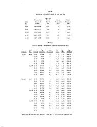
Tahlo 1. Ltjc <strong>of</strong> dopouica invesclfiit ed In iiort.hcr.n Oman<br />
y y<br />
Grid I.i>calluii r.vjlualion<br />
Host kock<br />
Cjoi'i^r Uf.-','i.-!i i t s<br />
n...salc - di.-ibaiitf<br />
ll;:salc - diabase<br />
Basalc<br />
CasalC<br />
B^auait<br />
Basalt<br />
Basalc<br />
Babalt<br />
Basalc<br />
Tuff '<br />
Basalt<br />
Cabbro - Peridotite<br />
Cabbro - Perliiocicc<br />
Cabbro - Pqrldoclce<br />
Peridotite<br />
Cabbro - Perltlodite<br />
(Ubbro - Peridotite<br />
Diabase - Cabbro<br />
Cabbro<br />
Peridotite<br />
Cabbro<br />
Cabbro<br />
Peridotite<br />
Cabbro<br />
Gabbru<br />
Peridotite<br />
. Peridotite<br />
Cabbru<br />
. ua!; b L'o<br />
Rafers co coordinates used on 1:100,000 oaps <strong>of</strong> Ministry <strong>of</strong> Defense,<br />
1^ United Klngdon, and on fig. 4, this report<br />
** > Probably useable<br />
Possibly useable<br />
Not useful 22<br />
Type <strong>of</strong> Deposit: Foraer Acclvlcy<br />
Pipe - Gossan<br />
Pipe - Cossau<br />
U:nscs - Cossan<br />
Lens** - Gossan<br />
Coasaa<br />
Plp« - Gossan<br />
Pipe.* Gossan<br />
Lens - Gossan<br />
Pipe - Gossan<br />
Bed<br />
Stockwork - Gossan<br />
Vain Zone<br />
V
J. i •^<br />
fA.<br />
J»J<br />
AM<br />
.w yn<br />
Mmk'^<br />
P4 diwii<br />
'p ^i<br />
1<br />
If?'<br />
Mr<br />
iM%<br />
mm<br />
Ho.<br />
JU<br />
Jl<br />
il<br />
33<br />
.4<br />
Table X. List -Jt deposits investigated in northern 0*ea—Continued<br />
2/<br />
Naioe . Grid Location Evalvtetlos<br />
Kalahay<br />
Niba I<br />
Kalahay 1<br />
Niba II<br />
Salaht • "<br />
Wasit<br />
Fanjah<br />
FA 597<br />
>A 787<br />
FA 822<br />
EA 589<br />
FA 137<br />
149<br />
215<br />
143<br />
338<br />
944<br />
)5 .Hasakirah FA 597 U9<br />
)6 Mudi FA 958 025<br />
).' Aka ICeya OB 026 736<br />
]B Kasansh FV 661 871<br />
)• Jaramah CV 791 .141<br />
.0 Wa«it ts 589 338<br />
Nujua FA .205 itao<br />
..• . .Cllah :, F3 ..n C2j<br />
>] Xuatag t.K ^10 .46?<br />
V. Ai Khadri • • EA 312 33y<br />
V<br />
.y<br />
Host Bock<br />
Iron Deposits<br />
Lecerlte<br />
Laterite<br />
Sendeeone<br />
Peridotite<br />
Laterite<br />
Chroaite Deposits<br />
Typ« <strong>of</strong> OepoalC Fonser Aictivity<br />
Keeorked laterite<br />
Dunite Scrlogers<br />
Perldotlta Layer<br />
(Dunite Stringers<br />
Kanganeea Ocgogics<br />
CItsrt<br />
Chert<br />
Cherc<br />
Lead-Zinc Deposit<br />
Silica-carbonate<br />
Hot Springs<br />
Pods<br />
Layer - Pods<br />
Velne<br />
Serpentine Spring<br />
Lisestoae Spring<br />
Llacston« Spring<br />
Wafers to coordinates used on 1:100,000 naps <strong>of</strong> Ministry <strong>of</strong> Defense,<br />
United Kingdom, and.on fig. 4, this report<br />
>. Probably useable-<br />
I Possibly useable<br />
. Sot useful<br />
23<br />
?<br />
Cue<br />
Cut<br />
Mine<br />
Falag
'"^I<br />
M<br />
I i.<br />
work will find other deposits that are either more remote, less well<br />
exposed,, or entirely-covered by a shallow layer <strong>of</strong> aluvlum.<br />
Copper Deposits in the Semail Ophiolite<br />
Copper deposits occur throughout the vast thickness <strong>of</strong> the Semail<br />
ophiolite, but those siliuated in the pillow lavas, especially those<br />
aear the top <strong>of</strong> the pillow layas, have the greatest potential. The<br />
position <strong>of</strong> the deposits within the ophiolite 13 shown dlagraimnatlcally<br />
on figure 5, which also gives added data regarding features <strong>of</strong><br />
mineralization that vary according to their position and host rock.<br />
The better copper deposits in the basaltic pillow layas are<br />
accompanied by large amounts <strong>of</strong> iron sulfide (pyrite), which where<br />
very concentrated may be a saleable product even without the copper.<br />
Through oxidation, the pyrite has given rise to sulfuric acid<br />
waters and colorful, extensively leached, gossan outcrops. These<br />
gossan zones, and doubtless the underlying ore bodiesf, are small in<br />
areal extent, being generally elliptical in plan with major axes<br />
<strong>of</strong> from 30-150 m (100-500 ft). A downward extent for an ore body to<br />
at least 225 meters (750 ft) has been proved by drilling at one<br />
deposit, and it is likely others may,extend to comparable depths.<br />
Some ore bodies, like Ghayth, are no^ elliptical but elongate and<br />
obviously deposited along a fault, whereas others show by a straight<br />
marginal segment partial fault control. Typically, little primary<br />
alteration exists about the deposits in basalt, although there is some<br />
evidence <strong>of</strong> zeolite alteration.<br />
The bright orange, red, brown, or yellow colors <strong>of</strong> the gossan<br />
makes the exposed deposits easy to find, especially if searched for<br />
from the air, see photos 15 and 17. However, distinguishing gossans<br />
over sulfide deposits containing copper from those containing just<br />
pyrite can be difficult. Where there are secondary copper minerals<br />
in the outcrop, the deposits have invariably been found and worked<br />
in ancient times, perhaps more than 3000 years ago. Black slag piles<br />
dot the landscape surrounding the deposits, and in some places there<br />
are extensive ruins <strong>of</strong> old reduction furnaces. But, where the<br />
leaching <strong>of</strong> the gossan has been most intense the original copper<br />
sulfides have been dissolved and no secondary copper minerals are left<br />
behind. As a result, in some promising deposits secondary copper<br />
minerals can be seen in the less altered periphery but not in the<br />
most mineralized core. For example, the intensely altered surface<br />
gossan in the core <strong>of</strong> the Lasail deposit shows virtually no copper,<br />
but drilling revealed the underlying sulfide zone contained several<br />
percent <strong>of</strong> ccpper ore as chalcopyrite in veins and disseminated<br />
crystals in massive pyrite. In some places, copper leached from a<br />
gossan is redeposited at the base <strong>of</strong> the leached zone, but as far as<br />
we are aware, no zone <strong>of</strong> secondary enrichment has been noted in the<br />
Lasail deposit. Some other deposits, for:example, Ghayth, Zabin, and<br />
Fizh, exhibit strong gossan with no secondary copper minerals showing<br />
ZU
^ !<br />
<<br />
rf<br />
:'^.<br />
-1<br />
-SS<br />
'* -a?^*'''"''<br />
.1<br />
I<br />
f<br />
i<br />
i<br />
\<br />
i<br />
t<br />
•,<br />
I<br />
%<br />
W'^<br />
Q-<br />
O<br />
LiJ<br />
CO<br />
O<br />
CJ.<br />
Oi<br />
^<br />
Chert<br />
UV4<br />
Qiabase.<br />
Gabbro<br />
Layered<br />
2one<br />
Peridotite<br />
y<br />
.serpent j„g<br />
LASAIL j /\AH..iA lUrDA<br />
Ghayth<br />
Khabiyat<br />
RAKAH<br />
SEflDA<br />
L Muden<br />
Jabah<br />
. Zabin<br />
Lushil<br />
Zahir Khafifzh } Masakivah j<br />
I SHWAYI I Luzak £edah I Eedah II<br />
L ^ Maydan V " Maydan 11 Bukathir Hawirdit<br />
|\i TaMi Ubaylah | Ghay) ichara Koowasl<br />
Tabakhat<br />
Inah<br />
l.MPORTANT. .<br />
LESS IMPORTANT<br />
Unpromi sing<br />
MUCH<br />
MUCH<br />
EXPLANATION<br />
I 1<br />
I SOME J<br />
SOME<br />
}<br />
Outlook<br />
for<br />
deposi ts<br />
Amount <strong>of</strong><br />
Fe or Gossan<br />
Amount <strong>of</strong><br />
copper<br />
shown by<br />
underlining<br />
Figure 5. Diagram showing distribution and other l^^"l "^<br />
29 copper-iron sulfide d.eposits In the Semail ophiolite.<br />
25
ki^^'^^y"<br />
either in core or periphery; we suspect these contain little or no<br />
primary copper sulfide but one cannot be sure without drilling.<br />
It can be safely preidicted that some <strong>of</strong>. the copper-bearing<br />
massive pyrite deposits in the pillow lavas will prove to be <strong>of</strong><br />
sufficient grade and size to be mineable, even though all facilities<br />
for mining and transport <strong>of</strong> ore to market must be installed. If it<br />
proves to be as expected, the ore <strong>of</strong> the Lasail deposit alone seems<br />
to be able to carry the cost <strong>of</strong> getting into operation. If some<br />
<strong>of</strong> the other deposits in the "Bowling Alley" can also be proven to<br />
be viable, as seems likely, mining them concurrently with the Lasail<br />
deposit will <strong>of</strong> course result in significant lowering <strong>of</strong> the<br />
Installation and operating costs on a per-ton basis. The.massive<br />
sulfide deposits in the pillow lava in Oman are much like the<br />
Intensively mined deposits in the Lower Pillow Lavas in the Troodos<br />
ophiolite on Cyprus,'which also were mined in ancient times (2500<br />
B.C.?) (Searle, 1972). The Cyprus deposits consist <strong>of</strong> several ore<br />
bodies <strong>of</strong>,1-10,000,000 tons <strong>of</strong> massive pyrite containing 1-4 percent<br />
copper occurring as chalcopyrite. Other deposits <strong>of</strong> similar type<br />
occur in Greece, Turkey, and Newfoundland (Upadhyay and Strong, 1973).<br />
The diabase dike, or "Sheeted Intrusive," part <strong>of</strong> the Semail<br />
ophiolite lying below the pillow lavas contains at its top only two<br />
known deposits, see figure 5. Both have well-developed gossan and<br />
are in all respects like the previously described deposits in the<br />
basaltic lavas.<br />
The lower gabbro and peridotite parts <strong>of</strong> the Semail ophiolite<br />
contain more than half <strong>of</strong> the copper deposits so far discovered In<br />
Oman, figure 5. Many <strong>of</strong> these were mined in ancient times, but only<br />
the Shwayi deposit seems to have any potential for modern mining,<br />
yiost <strong>of</strong> the deposits are .along a contact, generally a steep fault<br />
contact, between peridotite and gabbro. The mineralized zones are<br />
narrow, usually less than 8m (26 ft) wide, have lengths <strong>of</strong> less than<br />
300m (1,000 ft), and generally are poorly exposed. Primary<br />
chalcopyrite was found in some places, but the usual ore in outcrop<br />
contained only secondary copper minerals along shears and fractures.<br />
In one deposit we found pieces <strong>of</strong> chalcocite in veins <strong>of</strong> apparently<br />
primary origin. In contrast to the ores in the lavas, these deposits<br />
typically contain minor amounts <strong>of</strong> pyrite, and they generally<br />
exhibit only a little iron staining rather than heavy gossan. Their<br />
surface exposures are not prpminent, but assays Indicate several<br />
really contain copper ore as rich as found in the massive sulfide<br />
deposits.<br />
Most <strong>of</strong> these deposits in gabbro or peridotite are too small to<br />
be mined today. However, the Shwayi deposit, containing two ore bodies<br />
comparable in size to those in basalt, warrants some exploration to<br />
determine if the mineralized rock Is <strong>of</strong> ore grade. We are not too<br />
optimistic about it being mineable, however, as copper deposits in<br />
26
1" SB??---;<br />
Ml : gabbro and peridotite In othier parts <strong>of</strong> the world generally have not<br />
hi h<br />
'Ai-^<br />
J '»<br />
been economic.<br />
The origin <strong>of</strong> the copper deposits in the Semail ophiolite deserves<br />
further study, both as a guide to where to search for additional ore<br />
aad as a scientific contribution. At this state in their exploration,<br />
with almost ho knowledge <strong>of</strong> the primary ore mineralogy or paragenesls,<br />
tentative conclusions are best-drawn from*what is known <strong>of</strong> their<br />
localization and comparison with better explored ore bodies <strong>of</strong> similar<br />
type found elsewhere.<br />
As mentioned before, the mineable massive sulfide ores in the<br />
lavas in the upper part <strong>of</strong> the ophiolite are much like Cypriis ores,<br />
whose genesis has been studied by several geologists (Bear, 1963;<br />
Klnkel, 1966; Constantinou and Govett, 1972; Searle, 1972). However,<br />
the less promising chalcopyrite vein deposits found lower in the<br />
ophiolite are not well represented in Cyprus. There is general agreement<br />
that the Cyprus ores are ultimately derived from the ophiolite itself,<br />
but processes leading to their formation are debatable. The most<br />
generally accepted theory postulates that the sulfide deposits are<br />
formed at an oceanic spreading center about submarine springs, with<br />
deposition at the lava-water interface \and also in the underlying<br />
channelways by fracture filling and some replacement. The source<br />
<strong>of</strong> the copper, and generally also the iron, is believed to be either<br />
from leaching <strong>of</strong> underlying basalt, differentiation in a gabbroic magma<br />
chamber within the ophiolite sequence, or "exhalations" from the<br />
mantle itself. In some deposits <strong>of</strong> the Cyprus type, post-mineral<br />
faulting and remobllization <strong>of</strong> the sulfides has be;en proposed.<br />
In Oman, the massive iron sulfides occur only in the upper part<br />
<strong>of</strong> the ophiolite, mostly in the basalt, and it seems likely that the<br />
Iron was extracted from the iron-bearing rocks lower in the pile but<br />
above the peridotite. As copper mineralization is found throughout<br />
the ophiolite, the copper seems to have had a mantle origin. However,<br />
its greatest concentration is near the very top <strong>of</strong> the ophiolite, and<br />
the search for mineable copper deposits should give greatest priority<br />
to the examination <strong>of</strong> the pillow lavas, especially those at the very<br />
top <strong>of</strong> the lava pile. Overlying copper-rich sedimentary umbers, such<br />
as occur at Cyprus, have not been found; however, in the "Bowling<br />
Alley" somewhat similar sedimentary Ironstones occur interlayered<br />
with the uppermost pillow lavas. These ironstones are discontinuous<br />
and are nowhere more than 1 meter (3.3 feet) thick. Spectograjphic<br />
analysis show they contain high iron and manganese contents with only<br />
a little copper and nickel. Somewhat similar appearing Ironstones<br />
have been dredged from the Red Sea hot brine areas, but the Oman<br />
ironstones contain much less copper, lead, zinc, a-nd silver.<br />
The time <strong>of</strong> mineralization is unknown, and some evidence suggests<br />
that the final emplacement <strong>of</strong> the ore did not coincide with the<br />
period <strong>of</strong> volcanism and sea-floor spreading but came later. Some<br />
deposits in the "Bowling Alley" by their shape indicate fault control<br />
27
m<br />
t •<br />
in II<br />
*<br />
to the mineralization,- for example, the Ghayth and Semda deposits<br />
(figure 6). Others seem to lie along northwest-trending faults<br />
related to younger tectonics, for example, the Lushil, Fizh, Bayda,<br />
and Ghayth deposits. In addition, the northern trend <strong>of</strong> the "Bowling<br />
Alley" projected southward coincides exactly with the Maydan, Bukathir,<br />
and Hawirdit deposits in the peridotite, suggesting perhaps some<br />
deep-seated, fracture is responsible for the gross distribution <strong>of</strong><br />
most <strong>of</strong> the better copper deposits. Curiously,-far to the north<br />
in Iran, the spectacular Sher Cheshmeh porphyry copper deposit is<br />
* also along the extension <strong>of</strong> this line. While not enough is known<br />
J about why the ore is related to these .structural trands they can be<br />
J used as guides in exploration.<br />
«.<br />
Z<br />
y ?<br />
i<br />
t<br />
, i<br />
tl-<br />
• ?<br />
\<br />
el^ f^/i^/i i^rf-<br />
28<br />
\<br />
\ V
o<br />
CD<br />
CX ^L A e» A TiO*.<br />
lOal<br />
lot! 11<br />
Tevrace Oapos fl .<br />
•acfAAlL OPri, Oi.lT£ "<br />
F^<br />
.Pillovu L3>i as<br />
dm<br />
D'aba%e O'K'ei<br />
^MI • ^<br />
Lavj ered Gabb.-o<br />
k<br />
3<br />
0<br />
«<br />
u<br />
19<br />
c<br />
f<br />
Pe'.Jo+.te. j I<br />
Hawaii na AUochthooous<br />
CONTACT<br />
Noe.iir(»( P*ULT<br />
k C<strong>of</strong>>p«
Descriptions <strong>of</strong> copper deposits in volcanic rocks<br />
(1) Semda (DC 418-193 Fizh)<br />
The Semda deposit is located on isolated Interfluve between<br />
two wadies within low hills <strong>of</strong> Semail ophiolites 9.5 km (6 mi)<br />
north <strong>of</strong> the, village <strong>of</strong> Fizh. Part <strong>of</strong> the ore is clearly developed<br />
in diabase dikes, and the occurrence <strong>of</strong> pillow lavas nearby<br />
suggests that the deposit may be in the transition zone between<br />
pillows and sheeted dikes. A thick mantle <strong>of</strong> pediment gravels<br />
whose level upper surface is about 90 ra (300 ft) above the valley<br />
floor surrounds the mineralized <strong>of</strong> area on three sides and could<br />
be concealing other similar deposits. ^<br />
The mineralized zone is very conspicuous because <strong>of</strong> the bright<br />
yellow and redish brown colors <strong>of</strong> its intensely altered gossan,<br />
see photo 8. It is elliptical in shape with a long axis <strong>of</strong> 150 m<br />
(500 ft) and a short axis <strong>of</strong> 115, m (375 ft), as shown in figure 7.<br />
Its southern limit is partly covered by alluvium, but we believe<br />
the float here is adequate to permit an accurate estimate <strong>of</strong> its<br />
extent. Its northeastern boundary is locally straight and includes<br />
a tail-like extension, perhaps suggesting some fault control for<br />
the mineralization. Centrally located in the gossan is a nearly<br />
circular depression about 60 m (200 ft)' in diameter whose flat floor<br />
is 2 m (7 ft) below the level <strong>of</strong> the surrounding alluvial plain.<br />
Within this area all the material is a copper-free (?) powder <strong>of</strong><br />
secondary iron oxides, sulfates, and gypsum, which forms a thin mud<br />
when wet. Perhaps the level here has been lowered somewhat by<br />
mining in ancient times, but small step faults visible in the walls<br />
indicate that the depression <strong>of</strong> the central area is mostly due to<br />
subsidence. This is doubtless the result <strong>of</strong> removal <strong>of</strong> material<br />
in solution, which indicates that the underlying fresh material is<br />
chiefly soluble sulfides with a minimum <strong>of</strong> insoluble silicates.<br />
Surrounding the central core is a slightly less altered area pock<br />
marked by shafts or pits only a few feet deep and connecting short<br />
tunnels. Much green and blue copper "stain," in the form <strong>of</strong> both<br />
hydrated oxides and sulfates, is still visible in the walls, and<br />
it was doubtless from this less leached zone that the ancients<br />
obtained most <strong>of</strong>,the ore now represented by the extensive piles <strong>of</strong><br />
slag found all about the mine area.<br />
We believe the surface indications at the Semda deposit reflect<br />
a buried massive sulfide pipe with slightly less, but still Intense,<br />
mineralization extending out from it for a distance <strong>of</strong> several<br />
hundred feet. Althcu^h at che surface the leached gossan over the<br />
central core is virtually copper free, the presence <strong>of</strong> considerable<br />
copper in the less leached periphery suggests the core also may have<br />
a high copper content, and perhaps even a zone <strong>of</strong> secondary enrichment.<br />
There is no way to be sure, however, without drilling to<br />
obtain samples for analysis. To us this'appears to be the most<br />
promising deposit we examined, and it should be promptly explored<br />
JO
%f<br />
*'\t<br />
%'<br />
.'1<br />
"i<br />
#1<br />
I<br />
•It<br />
*•<br />
Hi<br />
',;<br />
s§y^<br />
Photo 0. Semda gossan viewed looking northeast. Central depression<br />
is in area <strong>of</strong> complete oxidation and has collapsed owing to<br />
removal <strong>of</strong> copper and iron in solution. Foreground area covered<br />
by pits from which copper ore was mined in ancient time. Flat<br />
skyline is on surface <strong>of</strong> old, elevated pediment gravel.<br />
3/
ly^s^'.-"'-<br />
O<br />
EXPLANATIOf^<br />
Slag<br />
Alluviup, and<br />
colluvium<br />
Gossan<br />
Pillov/ lava and<br />
diabase<br />
SEMDA COPPER DEPPSIT><br />
i OMAN<br />
N<br />
Area <strong>of</strong> complete<br />
oxi elation<br />
.''>r{;a cf ir.coiuplete<br />
oxidation and<br />
pit mining<br />
^. Limit <strong>of</strong> gossan<br />
; "^ outcroo and<br />
•_-/• concentrated float<br />
W^^^r Copper oxides in fracturci<br />
I^fe«*r^n fre5h diabase.<br />
M Iron oxide-s.<br />
SCALE<br />
.300 13* 1^^.<br />
Figure 7. Geologic map <strong>of</strong> the Semda copper deposit,<br />
31.<br />
Pit IS 7feet lower<br />
than surface <strong>of</strong><br />
surrounding, crfluv iutr<<br />
Cor.nass ar.d pac<br />
E;'. H. Bailey<br />
1?74
%<br />
Wt'<br />
by drilling. If it comes up to our expectations it is quite likely<br />
to be a mineable deposit.<br />
About 120 m (400 ft) north <strong>of</strong> the main gossan is a low hill<br />
<strong>of</strong> fresh diabase traversed by a shear zone containing copper "stain"<br />
along fractures. Still farther north is another weakly mineralized<br />
parallel zone. No iron mineralization seems to have been present<br />
in either <strong>of</strong>, these places. The direction <strong>of</strong> the mineralized<br />
fractures parallels the northeastern boundary <strong>of</strong>-the main gossan,<br />
and reinforces our belief that the main ore body is at least in .<br />
part fault controlled. Although a little digging has been done,<br />
these occurrences north <strong>of</strong> the main pit seem to <strong>of</strong>fer no chance<br />
for serious mining.<br />
(2) Lushil (DC 404-115 Fizh)<br />
The Lushil deposit lies in a small flat at the intersection <strong>of</strong><br />
two minor valleys 1.7 km (1 mi) east <strong>of</strong> the village <strong>of</strong> Lushil and<br />
near the road from the village to Fizh. It is in an area <strong>of</strong> rather<br />
subdued topography west <strong>of</strong> a bold outcrop <strong>of</strong> diabase dikes that<br />
are vertical and trend northerly. Just west <strong>of</strong> the deposit are<br />
low hills <strong>of</strong> mafic pillow lava. Although the diabase nearby is cut<br />
by northwest-trending faults, we have no evidence suggesting a<br />
fault between the diabase and lavas that'mighty have aided in<br />
localization <strong>of</strong> the ore deposit.<br />
The exposure <strong>of</strong> the deposit consists <strong>of</strong> a ground-level circular<br />
area about 30 m (100 ft) in diameter <strong>of</strong> strongly oxidized gossan,<br />
see photo 9 and figure 8. We saw no copper minerals or "stain" in<br />
the gossan, and no piles <strong>of</strong> slag indicating it had ever been mined.<br />
The surrounding rocks are unmineralized and surprisingly unaltered.<br />
The gossan probably has developed over a small pipe <strong>of</strong> massive iron<br />
sulfides, but its small size and lack <strong>of</strong> any sign <strong>of</strong> copper<br />
mineralization indicates further exploration is unwarranted.<br />
The area about the deposit also seems unfavorable because <strong>of</strong><br />
the lack <strong>of</strong> alteration or mineralization in the exposed rocks.<br />
In the valley a few hundred feet northeast <strong>of</strong> the gossan, however,<br />
there is an area <strong>of</strong> powdery soil containing some gypsum in which<br />
the geophysicists for Prospection Ltd. report a slight geophysical<br />
response. We believe the lack <strong>of</strong> surface alteration or the<br />
development <strong>of</strong> a good iron-stained gossan indicates little chance<br />
for the discovery <strong>of</strong> covered ore in this area.<br />
33<br />
\ ^<br />
U<br />
''
€|<br />
^m<br />
5|S<br />
I M<br />
vi r<br />
^k<br />
^m<br />
If*<br />
EXPLANATION<br />
Alluvium<br />
Gossan<br />
[jsT^ Mafic lava, with<br />
^ pillows<br />
[^ Oiabase<br />
Edge <strong>of</strong> shallow wadi<br />
•--''Drainage<br />
LUSHIL COPPER DEPOSIT.<br />
OHM<br />
ra<br />
••.Trv"-^./<br />
too 2O0 300 >400 fjoo P4.<br />
SCALE<br />
Figure 8. Geologic map <strong>of</strong> the Lushil deposit,<br />
34:<br />
CoiTipass and pace<br />
I. H. Bailey<br />
1974
X<br />
Photo 9. Entire area <strong>of</strong> exposure <strong>of</strong> Lushil gossan^ viewed looking north<br />
35^
A aire?''<br />
IK<br />
1^1<br />
-«mv<br />
-^1<br />
.^.1<br />
VJ<br />
fl<br />
''di<br />
m<br />
hi<br />
1<br />
t<br />
(3) Zabin (DC 358-098 Fizh)<br />
The Zabin deposit is 1.1 km (0.6 mi) S22''E <strong>of</strong> Zabin village<br />
and 8 km nearly due west <strong>of</strong> Fizh. It is exposed as several hills<br />
<strong>of</strong> iron-stained gossan and an lnterve.ning low area <strong>of</strong> bleached<br />
rock, see photo 10. The deposit is at the erosional boundary<br />
between an upper tableland floored by old gravels at least 9 m<br />
(30 ft) thick and a new pediment being established at a level<br />
that is 75 m (250 ft) or so lower. Small hills xit mafic volcanic<br />
rock exposed on the flank <strong>of</strong> the erosional scarp contain the main<br />
deoosit. and other minor shows <strong>of</strong> mineralized volcanics can be seen<br />
through the riew pediment along the edge <strong>of</strong> incised wadies<br />
to the north. On the north side <strong>of</strong> a major wadi 500 feet north <strong>of</strong><br />
the main deposit is exposed a contact between the volcanic rocks<br />
and underlying diabase dikes, suggesting that the deposit is nea.r<br />
the base <strong>of</strong> the volcanic flows. The attitude <strong>of</strong> the dikes suggests<br />
backward rotation <strong>of</strong> this part <strong>of</strong> the Semail ophiolite.<br />
Three main areas <strong>of</strong> mineralized rock exposed at the Zabin<br />
deposit are nearly surrounded by alluvium, see figure 9. The<br />
southern two, separated only by alluvial cover, could be parts <strong>of</strong><br />
one continuous mineralized mass, and the main northern exposure<br />
also might extend northwestward beneath cover to the small<br />
exposures shown along the wadi bank on\figure 9. Between these<br />
two clusters <strong>of</strong> mineralized rock is fresh volcanic rock, which<br />
niakes it improbable that the north and south deposits are exposures<br />
<strong>of</strong> a single ore body. .^ projection <strong>of</strong> the S. 49° E. trend <strong>of</strong> the<br />
mineralized zone to the southeast reaches fresh volcanics in the<br />
next wadi to the south, indicating the mineralization does not<br />
extend far beneath cover in that direction.<br />
The most intense mineralization, as indicated by a well-developed<br />
deep-red gossan <strong>of</strong> iron oxides in a silicate framework, comprises<br />
the most southerly gossari mass shown on the map. It forms the<br />
western part <strong>of</strong> a prominent hill, which has little-altered pillow<br />
lava in its eastern part. Although the gossan is striking because<br />
<strong>of</strong> its color, much initial silicate remains, indicating the<br />
unoxidized rock below is only partially replaced by sulfides.<br />
Neither here nor elsewhere in this area did we observe any copper<br />
mineralization, and there is no slag or other evidence <strong>of</strong> ancient<br />
mining about these prominent exposures. The gossans probably overlie<br />
pyrite mineralization with little or no copper. The surface showings<br />
are not encouraging enough to warrant further exploration.<br />
36
df<br />
.h<br />
ill<br />
dM<br />
""^1<br />
fcffw'"'<br />
'1*1 1 •<br />
'i/^ i^V '&'3 K<br />
^*^<br />
••ill p<br />
i '<br />
Ii<br />
m<br />
Photo 10. Area <strong>of</strong> Zabin deposit viewed looking northwest. Intense<br />
alteration extends from colorful hill tliis side <strong>of</strong> Land Rover<br />
to bleached zone just this side <strong>of</strong> broad, alluvial-filled wadi,<br />
Hov/ever, a little alteration is found along the trend <strong>of</strong> the<br />
zone on the far side <strong>of</strong> the wadi.<br />
37
^•^ %^4<br />
JM<br />
*.fc^i<br />
/ ^<br />
"?^ra^<br />
M<br />
^AM<br />
-,'11<br />
't«'^^^<br />
''il^'l<br />
vlr^i<br />
'^1<br />
%m<br />
m ^fWi<br />
i '^ili<br />
P^<br />
^^<br />
u^^<br />
1<br />
V AJI<br />
g^t<br />
i>M<br />
y^<br />
4<br />
di<br />
4 ^-^<br />
M<br />
••>iT.».<br />
i<br />
if<br />
W<br />
^<br />
>f,tT«"'<br />
EXPLANATION<br />
Alluvium and<br />
colluyium<br />
N<br />
Strongly mineralized<br />
volcanic rock,<br />
gossan<br />
Weakly mineralized<br />
volcanic rock<br />
Mafic volcanic rock;<br />
local pillows<br />
r*'
1<br />
di<br />
5i<br />
.4<br />
'•''"ii<br />
fi<br />
4<br />
sf<br />
sswf-w -<br />
(4) Fizh (DC.345-068 Fizh)<br />
The Fizh deposit Is 0-3 km south <strong>of</strong> wadi Fizh and 1.8 km (1.1<br />
ai) east <strong>of</strong> the village <strong>of</strong> Mahjal. It is easily found as it<br />
consists <strong>of</strong> two unusually dark hills rising from a broad pediment<br />
surface, which is cut down about 3 m (10 ft) into an older alluvial<br />
terrace, see photo 11. A mountain front nearby consists <strong>of</strong> northerly<br />
trending diabase dikes, but the deposit itself ts in altered mafic<br />
pillow lava.. The lava appears to lie about 45 m (150 ft) above<br />
the contact with the zone <strong>of</strong> dikes; thus,"the geological setting<br />
here is identical with that <strong>of</strong> the Zabin deposit.<br />
The deposit forms two parallel mounds having a narrow connecting<br />
band at their northern end, see figure 10. The mounds consist <strong>of</strong><br />
gossan made up chiefly <strong>of</strong> deep brown, locally black, goethite,<br />
yellowish brown limonite, and deeply stained silica. Some very black<br />
siliceous material Is thinly layered and perhaps is mineralized<br />
chert. There is a vague suggestion that the hard gossan is a cap<br />
extending little below the pediment level. No copper minerals were<br />
seen, and no evidence <strong>of</strong> former mining was observed.<br />
The pair <strong>of</strong> mineralized hills is surrounded by alluvium, but<br />
there are enough small patches <strong>of</strong> unaltered volcanic rock sticking<br />
up through the alluvium on all sides to eliminate any speculation<br />
about the area <strong>of</strong> mineralization extending much farther beneath the<br />
cover. Also, the small exposure <strong>of</strong> volcanic rock on the inside<br />
edge <strong>of</strong> the eastern lobe, see figure 10, suggests the mineralization<br />
is not continuous between the two lobes beneath the intervening cover.<br />
The Fizh deposit does not appear to us to warrant further exploration.<br />
(5) Khabiyat (DC 397-013 Fizh)<br />
The Khabiyat deposit is 4.5 km (2.8 mi) S. 29" W <strong>of</strong> Jabal Shaykh<br />
and 0.3 km (CIS ml) west <strong>of</strong> the main road up the east side <strong>of</strong> the<br />
"Bowling Alley". It lies on a flat alluvial surface between the main<br />
Oman Mountains and a smaller range <strong>of</strong> hills comprised <strong>of</strong> Semail gabbro<br />
and diabase. The only exposures in the mineralized area are seven<br />
small Isolated patches <strong>of</strong> gossan that protrude above the alluviated<br />
plain. The gossans are strongly leached and consist mostly <strong>of</strong><br />
residual silica with some yellow and brown iron oxides. They contain<br />
no visible copper minerals, and apparently were not mined in ancient<br />
times. Owing to the advanced degree <strong>of</strong> alteration <strong>of</strong> the rocks in<br />
these few exposures we are uncertain about the nature <strong>of</strong> the host<br />
rock, but it probably was a mafic volcanic rock. The limited showings<br />
do not appear to us co merit further exploration.<br />
k<br />
&m 39
mM'~<br />
EXPLANATION<br />
hJ<br />
mineratiied<br />
Alluvium and colluvium<br />
Tfirrace deposit<br />
OTM Gossan, ir.ineralized<br />
^ volcanics and chert<br />
^ Diabase dike<br />
^tafic volcanic rock<br />
y*^ Edge <strong>of</strong> wadi<br />
FIZH COPPER DEPOSIT.<br />
OMAN<br />
''^.y
Mi<br />
m<br />
p^pd^ m.<br />
^t^g W\'<br />
' c^i<br />
** S^^ji Q^J<br />
•*• ^4l Wt<br />
dm<br />
>' -f^M<br />
y%<br />
di<br />
Al<br />
M<br />
y<br />
pm<br />
A^<br />
'"i<br />
W<br />
i<br />
wi-<br />
Photo 11. Gossan hills <strong>of</strong> the Wadi Fizh deposit, viewed looking southeast<br />
Rock in right foreground is nearly fresh basalt.<br />
^1
m<br />
,y<br />
•yM<br />
w<br />
'if<br />
£9<br />
m<br />
\f<br />
41<br />
»;'?'<br />
(6) Bayda (DB 408-939 Fizh)<br />
The Bayda copper deposit is on the east side <strong>of</strong> the "Bowling<br />
Alley" about 1.1 km (0.6 ral) S. 54" E <strong>of</strong> the village <strong>of</strong> Bayda.<br />
It occupies a slope leading up from an area <strong>of</strong> low hills <strong>of</strong> mafic<br />
volcanic rocks to a high-level flat blanket <strong>of</strong> old gravels. The<br />
mineralized zone is intermittently exposed through a mantle <strong>of</strong> talus<br />
broken from the gravel above, see photo 12.<br />
The ore deposit is a zone <strong>of</strong> slightly to intensely altered<br />
volcanic rock extending for about 180 m (600 ft) in a northerly<br />
direction and having an average width <strong>of</strong> about 45 m (150 ft), see<br />
figure 11. The alteration is the most intense along the west side<br />
<strong>of</strong> the zone, where some local areas are so leached that only white<br />
silica remains. In other parts there has been less acid leaching<br />
and the rocks are deep brown to yellow in color owing to the<br />
abundance <strong>of</strong> iron oxides and sulfates. A little copper "stain"<br />
can be seen throughout but is most common along the western margin<br />
where some mining was done in open cuts and perhaps through a<br />
shallow shaft. Jasper is exposed above the west edge <strong>of</strong> the ore<br />
zone, and a hill on its southern end is mostly jasper. We are not<br />
certain if the jasper is a cherty sediment or is the result <strong>of</strong><br />
silicification related to the ore genesis; however, local layering<br />
suggests at least part is primary.<br />
The deposit contains some copper and has been mined on a<br />
small scale. We saw no slag, but perhaps some <strong>of</strong> the slag about<br />
the nearby Aarja deposit represents ore carried from here.<br />
Although the sulfide mineralization does not seem to be intense<br />
through the entire width <strong>of</strong> the altered zone, we believe the showing<br />
is <strong>of</strong> sufficient size and merit to warrant at least a couple <strong>of</strong><br />
exploratory drill holes. We also noted some iron staining in the<br />
hills across the wadi about 1 km (0.6 mi) to the north, but did<br />
not have time to inspect it closely.<br />
f2
^»s<br />
m<br />
I<br />
1^<br />
:.l.l-..:-SK"-J<br />
rsi<br />
•f ^ « Alluvium and colluvi I urn<br />
Ai<br />
%ii<br />
^*|<br />
dm<br />
iM<br />
md 'crrace deposit<br />
y .'(ineralized volcanic rock<br />
J?f«<br />
.^ Jasper (silicified tuff?)<br />
^ ."tdfic volcanic rock,<br />
soma pillows<br />
f ('"') Probable limit <strong>of</strong><br />
% '^-' mineralized rock<br />
f ^.y Drainage<br />
Figure 11. Geologic map <strong>of</strong> the<br />
BAYDA COPPER DEPOSIT.<br />
H3<br />
O.IA:I<br />
..><br />
Compass and pace<br />
f-;. H. Bailev<br />
1974<br />
lOO too ^oo<br />
SCALE<br />
Bayda copper deposit.
Photo 12. Bayda copper deposit viewed looking north. In upper left<br />
arc old workings in area <strong>of</strong> gossan and bleached volcanic rock.-<br />
Ccntor skyline is cap <strong>of</strong> older alluvium. Low hills to right <strong>of</strong><br />
central area <strong>of</strong> white beached rock are composed <strong>of</strong> unmineralized<br />
pillow basalt.<br />
4'f
(7) Aarja (DB 402-925 Fizh)<br />
The Aarja deposit lies among low rolling hills surrounded by<br />
alluvium in an interfluve between two large wadies 2 km (1.2 mi)<br />
south <strong>of</strong> the village <strong>of</strong> Bayda and 1 km west <strong>of</strong> the "Bowling Alley"<br />
road. The country rocks are mafic pillow lavas, locally cut by<br />
a few diabase dikes. The deposit is probably near the top <strong>of</strong> thtf"<br />
Semail ophiolite as beds <strong>of</strong> cherty ironstone 0.5-1 m (2-3 ft) thick<br />
occur with the ore, and some silicified tuffs were'also noted<br />
nearby.<br />
The deposit is expo sed as a brightly colored hill about 25 m<br />
(85 ft) high composed <strong>of</strong> intensively altered gossan <strong>of</strong> iron-stained<br />
silicates, white silica, limonite, geothite, and other typical<br />
products <strong>of</strong> intense sulf ide mineralization and subsequent acid<br />
leaching, see photo 13. Secondary copper minerals are fairly common,<br />
especially near the top o f the hill and along the base <strong>of</strong> its western<br />
slope, where there has b een considerable mining. The extent <strong>of</strong><br />
mining is indicated by t he widespread piles <strong>of</strong> slag, which in the<br />
aggregate amount to more than 25,000 tons.<br />
The prominent gossan exposure measures 120 by 60 m (400 by<br />
200 ft), but abundant float suggests that the ore body is larger<br />
Chan this, see figure 12. We believe it is elliptical in shape<br />
with lengths <strong>of</strong> major and minor axes <strong>of</strong> 165 and 100 m (550 and<br />
350 ft). It is elongated in a northwesterly direction, parallel<br />
CO the prevalent direction <strong>of</strong> faulting in the "Bowling Alley" area.<br />
However, we saw no surface expression <strong>of</strong> a fault here, and are not<br />
able to relate the structure to the fault along which is developed<br />
Che nearby Bayda deposit.<br />
Because <strong>of</strong> the size <strong>of</strong> the gossan and its copper content it<br />
may represent a mlnable deposit, although the sulfide replacement<br />
does not appear to have been as complete as at the Lasail or Semda<br />
deposit. We recommend that it be further explored by at least<br />
three drill holes to determine the grade <strong>of</strong> the primary ore and<br />
its extent beneath the alluvial cover.<br />
45
• I.<br />
• i<br />
3<br />
^'i<br />
1<br />
?<br />
I'i<br />
r>4<br />
[XPLANATIOi-l<br />
Slag; number<br />
shows averagt<br />
depth in feet<br />
Alluvium and<br />
colluvium<br />
_ Gossan; mineralized<br />
1^ volcanic rocks and<br />
cliert<br />
_] Possible gossan, as<br />
labelled<br />
i^ ."'".afic volcanic rocks<br />
^ Edge <strong>of</strong> wadi<br />
t^\ f i»*:w^:<br />
-. .. V
-~wrr^-<br />
Rfp-"'''"<br />
Photo 13. Aarja copper deposit, viewed looking southeast. The highest<br />
parts <strong>of</strong> the prominent gossan hill contain mineralized chert.<br />
Flat skyline on left is surface <strong>of</strong> overlying old alluvium deposited<br />
in a prior cycle <strong>of</strong> erosion.<br />
hi
IS<br />
i!<br />
(8) Ghayth (DB 428-905 Wadi Al Jizzi)<br />
The Ghaych depo.sit extends along a narrcv/ alluviated valley<br />
between low hills about 4 km (2.5 mi) N. 23° E. <strong>of</strong> ruins <strong>of</strong><br />
Mulayyinah on the bank <strong>of</strong> Wadi Jizzi. The valley is bordered by<br />
hills <strong>of</strong> mafic volcanic rock, locally showing pillow structure,<br />
and to the southwest other hills contain cherty ironstone beds<br />
0.6 to 1 ra (2 to 3 ft) thick.<br />
The exposure <strong>of</strong> the deposit consists <strong>of</strong> brick-red, orange,<br />
and locally black gossan cropping out as lov; mounds or as nearground-level<br />
patches along a zone extending N. 14" W., see photo<br />
IA and figure 13. This zone developed along a vertical fault<br />
Chat may be the southern extension <strong>of</strong> the fault on which occurs<br />
the Bayda deposit.<br />
The Ghayth deposit is exposed over s length <strong>of</strong> a little<br />
more than 400 m (1,400 ft). Its northern end is about at the<br />
limit <strong>of</strong> exposure, as a short distance farther north along the<br />
strike <strong>of</strong> the fault fresh volcanic rock can be seen. To the.<br />
south, the deposit might extend farther under coyer, as its<br />
projection goes under a capping <strong>of</strong> thick terrace gravels. The<br />
northern part <strong>of</strong> the gossan zone has an exposed width <strong>of</strong> about<br />
30 ra (100 ft), but the southern part, which is less well exposed,<br />
appears to be less than 15 m (50 ft) wide.<br />
The gossan has not been mined and we saw no copper minerals<br />
in it. From the leached surface exposures we judge that it<br />
overlies a narrow vein <strong>of</strong> massive pyrite with borders <strong>of</strong> volcanic<br />
rock containing varying amounts <strong>of</strong> disseminated pyrite. Owing<br />
Co the total absence <strong>of</strong> copper "stain" it appears to have no<br />
economic potential, but its extent is sufficient to warrant a<br />
single exploratory drill hole to obtain samples <strong>of</strong> the unoxidized<br />
ore. Mineralized areas shown on figure 13 to the east <strong>of</strong> the<br />
main ore zone represent weak alteration and are not worth further<br />
attention.<br />
Uft
iff'<br />
*-.•?<br />
*,•»»• ?,S^<br />
4'<br />
yi<br />
jmh<br />
fM<br />
. fi<br />
"HI<br />
"'«<br />
M<br />
d h^<br />
(V"'"'<br />
N<br />
Mineralized rock is<br />
resistant and tends<br />
to crop out; probab<br />
little lies beneath<br />
cover.<br />
Compass and pace<br />
E. H. Bailey<br />
1974<br />
liiiwwiiiWWPWIIWiiiii<br />
GHAYTH DEPOSIT.<br />
OMAN .<br />
EXPLAM/MION<br />
Alluvium, colluvium,<br />
and terrace deposits<br />
Gossan and mineralized<br />
volcdnic rock<br />
Mafic volcanic rock,<br />
some pillows<br />
yy^ fdge <strong>of</strong> wadi<br />
Drainage<br />
Figure 13. Geologic map <strong>of</strong> the Ghayth deposit.<br />
SCALE
-t^p<br />
,^3<br />
m<br />
Ap<br />
if<br />
'^^<br />
AI<br />
C'<br />
*,;^ai^.^-..::.*:;;!te;7.B^y^^:<br />
Photo 14. Ghciyth gossan zone viewed from southern ona looking north.<br />
Virtually the full extent <strong>of</strong> the minor.il ized 7oiir is shown in the<br />
photo. Rordering rocks are mafic pillow lava ana hills beyond<br />
are gabbro.<br />
50
.tJI<br />
di<br />
"«<br />
m<br />
d)<br />
(9) Lasail (DB 422-843 Wadi Jizzi)<br />
The Lasail deposit occupies a depression within low hills <strong>of</strong><br />
pillow lavas, d.Lkes, and sills 2.7 km (1.7 mi) S. 14° E. <strong>of</strong> the<br />
ruins <strong>of</strong> Hulay/inah. on Wadi Jizzi. The area appears to be synclinal,<br />
and the occurretnce <strong>of</strong> dark, iron-rich sedLT.ants overlying pillov/<br />
lavas suggests that the ore body lies at the top <strong>of</strong> the Semail<br />
ophiolite pile. Local diabase dikes trend northward and dip at<br />
moderate angles westerly. Because <strong>of</strong> the advanced study made her.e<br />
by Prospection Ltd., who believe this to be'the most promising ore<br />
body yet discovered in Oman, we made no attempt to map the deposit.<br />
The exposure <strong>of</strong> the ore body consists <strong>of</strong> a flat low area <strong>of</strong><br />
striking orange, red, and brown powdery gossan said to measure<br />
270 m (900 ft) by 135 m (450 ft), see photo 15 and 16. Diamond<br />
drilling by Prospection Ltd. has shown that the gossan has formed<br />
over a pipe <strong>of</strong> massive sulfide ore having a vertical extent <strong>of</strong><br />
at least 210 ta (700 ft), the depth <strong>of</strong> penetration by the equipment<br />
available. Little data on the content <strong>of</strong> copper in the drill core<br />
is available to us. But substantial sections are said to assay<br />
2-3 percent copper, occurring as chalcopyrite veins and crystals<br />
in massive pyrite. With only partial knowledge <strong>of</strong> -the preliminary<br />
drill data we estimate the known amount <strong>of</strong> ore may be between 5<br />
and 10 million tons <strong>of</strong> massive pyrite ore containing 2 1/2 percent<br />
copper. Cost calculations indicate this deposit can be mined at<br />
a pr<strong>of</strong>it under present conditions if the potential tonnage and<br />
grade are as indicated.<br />
Copper "stain" and relics <strong>of</strong> copper in vesicles in the lava<br />
can be seen at the deposit. This was the site <strong>of</strong> the most extensive<br />
ancient mining we saw, and the slag heaps lying all about the<br />
gossan liave been estimated to contain 100,000 t* <strong>of</strong> roasted ore.<br />
*t, metric tons<br />
'Pi
y.<br />
At<br />
5<br />
?itoto 15. Lasail copper deposit<br />
as viewed from the air looking due<br />
north. Black, pock-marked., a reas surrounding gossan are ancient<br />
slag piles, which are estimated to contai'n'at least"l<br />
Drill rig in center <strong>of</strong><br />
00,000 tons,<br />
photo to right <strong>of</strong> wet area is set<br />
Prospection Ltd. DDH-2<br />
up at<br />
'^•m;yp<br />
wmm^i
Photo 16. Central ptirt <strong>of</strong> gossan o\/er the Ltisai^ ore. oody lOOKing<br />
west. Conical piles <strong>of</strong> various colors to left <strong>of</strong> Land Rover<br />
represent material from pits at 0,5 (l,b3 feet)-iiiot
t^MW^^<br />
fi<br />
ST<br />
Am<br />
t 1|<br />
fMJi<br />
lis<br />
(10) Jabah (FB 247-002 Udhaybah)<br />
,~,.««w-.mimmmamimmmimmiimmmS9SSll&.<br />
The Jabah occurrence lies among low rolling hills along Wadi<br />
Jalsa approximately 5 km (3 mi) S. 43* E. from the village <strong>of</strong><br />
Rusayl on the main road to Muscat. The area is underlain by pillow<br />
lava which is capped by 1 m (3.3 ft) <strong>of</strong> silicified leucocratic<br />
tuff containing plagioclase phenocrysts. At the contact a thin<br />
bed <strong>of</strong> chert separates the tuff and pillow lava,and secondary<br />
copper minerals occur sporadically at the-chert-tuff interface.<br />
.Uthough an analysis <strong>of</strong> tuff in the mineralized zone shows 2.9Z<br />
copper (see table 6 in Appendix), we recommend no further work here.<br />
(11) Rakah (DB 570-182 Mlskin)<br />
The Rakah copper deposit is exposed as a group <strong>of</strong> low hills<br />
partly covered by alluvium 11.2 km (7 ml) N. 21' E. <strong>of</strong> Yanqual<br />
Fort, from which it is readily accessible. The main mineralization<br />
is in mafic volcanic rocks, but in adjacent diabase and nearby<br />
gabbro there has also been some mineralization along fractures.<br />
Boundaries between the different kinds <strong>of</strong> rock are apparently<br />
northeasterly trending faults, and it is likely that here the<br />
Semail ophiolite is also overturned.<br />
The deposit is exposed as a colorful gossan <strong>of</strong> brown, yellow,<br />
and orange iron oxides and white silica, with other products <strong>of</strong><br />
secondary alteration and acid leaching, see phcto 17 and 18.<br />
Locally, however, a little pyrite still remains in the outcrops.<br />
The surface area <strong>of</strong> the mineralized zone is rectangular in shape<br />
and about 240 m by 120 m (800 by 400 ft) in dimension, see figure<br />
14. Secondary copper minerals can be seen in several parts <strong>of</strong> the<br />
gossan, and mineralization is particularly Intense along northeasttrending<br />
shear zones in the central area and near the northwestern<br />
margin where cuts, and some underground workings, attest to ancient<br />
mining. Scattered about the deposit are many piles <strong>of</strong> slag which<br />
in the aggregate are estimated to contain about 20,000 tons. Also<br />
in the area are several well-preserved fire pits where the copper<br />
was roasted out <strong>of</strong> the ore.<br />
The size <strong>of</strong> the Rakah deposit and the prevalence <strong>of</strong> some copper<br />
minerals in its gossan requires that it be explored by a few.drill<br />
holes. However, the surface showings do not appear as in some <strong>of</strong><br />
the deposits in the "Bowling Alley", and the remoteness <strong>of</strong> this<br />
deposit from all others <strong>of</strong> merit would make it difficult to operate<br />
it as one <strong>of</strong> several supplying a single concentrating plant.<br />
t-ii
N<br />
EVPL/IWATIOW<br />
Slag, number .shows depth in feel<br />
asB Alluvium and colluvi<br />
Idfyj Terrace cieposlt<br />
^ ^ Mafic volcanic root;<br />
rli^ Oiabase<br />
^ fioscah<br />
RAKAH COPPER DEPOSIT.<br />
« ^<br />
OMAN<br />
Comoass ar.d pace<br />
r;'. ii. Bailey<br />
1974<br />
Figure 14. Geologic map <strong>of</strong> the Rakah copper deposit.
i-'W".*^
?iwio 18. Northern part <strong>of</strong> the Rakah gossan zone where a little underground<br />
mining has l)een done, viewed looking west Low greenishgray<br />
slope beyond ore zone is composed <strong>of</strong> diabase dikes; high<br />
range beyond is chiefly gabbro.<br />
5 7
'^%^WtS-<br />
» i Vl<br />
>fd Description <strong>of</strong> copper deposits in gabbro and peridotite<br />
Ai<br />
' m<br />
riA<br />
m<br />
' i^<br />
'i f<br />
hpl<br />
(12) Maydan I (D3 390-334 Qii..ayrah)<br />
The Maydan I deposit is in a narrow wadi about 1.5 km (1 rai)<br />
east <strong>of</strong> Tawi Salaraah, which is in VJadi Ahin. Here for 450 m (1,500 ft)<br />
along an easterly trending shear zone in a peridotite screen in gabbro<br />
occur scattered veinlets <strong>of</strong> malachite, see figure 15. The mineralization<br />
is most intense in two zones near tlie margins <strong>of</strong> the peridotite, and<br />
in thsm generally copper stains v/ere seen over widths <strong>of</strong> only a few<br />
feet. Although small slag piles indicate some ancient mining here,<br />
the deposit seems to have no potential for modern mining. •.-<br />
(13) Maydan II (DS 380-343 Ouniavrch)<br />
This deposit, which is also knovm as the Salama deposit, is less<br />
than 1 km (0.6 mi) west <strong>of</strong> the village <strong>of</strong> Maydan in Wadi Ahin and about<br />
2 km (1.6 ni) northwest <strong>of</strong> the Maydan I deposit. As' shown in photo 19<br />
and figure 16, copper mineralization occurs in a shear zone separating<br />
cumulate peridotite from coarse-grained, locally pegmatitic gabbro.<br />
Across a small wadi 210 m (700 ft) to the south are prominent exposures<br />
<strong>of</strong> diabase dikes v;hich strike almost due north and dip steeply eastward.<br />
The mineralized shear zone forms a bench 6-9 m (20-30 ft) wide on a<br />
scutht^est-facing slope and is in most places covered with talus. At<br />
its east end is a good exposure <strong>of</strong> the ore zone, but here chalcopyrite<br />
and secondary copper minerals are confined to a zone only 1 foot v/ide.<br />
The debris-covered bench is largely the result <strong>of</strong> ancient mining, and<br />
perhaps the ore zone was somewhat wider in this part. The scale <strong>of</strong><br />
ancient mining is indicated by the size <strong>of</strong> the slag piles found on<br />
each side <strong>of</strong> the wadi and estimated to contain about 7,000 t. The<br />
deposit ia too small to be <strong>of</strong> interest today.<br />
(14) Bu Kathir (DB 374-149 Dank)<br />
The Bu Kathir deposit is about 16 km (10 mi) west <strong>of</strong> Yanqul and<br />
2.1 km (1.3 mi) south <strong>of</strong> the village <strong>of</strong> Bu Kathir in a small canyon<br />
that can be reached only on foot. Most <strong>of</strong> the rocks in the canyon wall<br />
are layered gabbro, but the ore shoxjings occur in a fault-bounded screen<br />
<strong>of</strong> serpentinized peridotite. Secondary copper minerals are scattered on<br />
shear surfaces in a zone trending N. 60 W. and dipping 70 S. Copper<br />
"stain" occurs erratically over,a width <strong>of</strong> generally less than 2 feet<br />
for a length <strong>of</strong> about 5GG feet, and there are minor shows even beyond<br />
this. Selected pieces <strong>of</strong> mineralized rock from the ore zone gave 11.0<br />
percent copper. The zone was formerly mined through one adit near its<br />
center and several small open cuts, but two slag piles noted in the area<br />
contain probably less than 1,000 t <strong>of</strong> roasted ore. In spite <strong>of</strong> the<br />
richness <strong>of</strong> the selected pieces, the showings do not warrant additional<br />
work.
-*•'» mji<br />
»id%<br />
^1<br />
•i<br />
Via<br />
' 2<br />
.Ml"'<br />
wfel<br />
W.>-V.f''- ^'5<br />
L„i*'/^iov- "*- • ^-v-^f d.' ><br />
C'i--.'^-- -* '.,<br />
^ Peridotite, mostly<br />
^^^ serpentinized ccr;r»c-.-: ?.nd pact:<br />
Collu.T Grar.t end £. H. cailc---<br />
1074<br />
Figure 15. Geologic map <strong>of</strong> the Maydan I copper deposit,<br />
53<br />
i^y
f<br />
w<br />
riJ<br />
EXPLA^iATION<br />
Slag; number shows<br />
«^ average depth in<br />
[i3 Alluvium and<br />
**^ colluvium<br />
Mineralized shear<br />
zone •<br />
Diabasvi dikes<br />
iiiil Gabbro<br />
j ^ Cumulate peridotite;<br />
serpentinized<br />
^ Edge <strong>of</strong> i vadi<br />
.y<br />
Small canyon<br />
•^AYD,AN II COPPER DEPOSIT<br />
OMAN<br />
SCALE<br />
One fo<strong>of</strong> <strong>of</strong> sheared<br />
ond mmeralized '"ock<br />
Compass and Dace<br />
E. H. Bailey<br />
1974<br />
if: is» Ft<br />
Figure 16. Geologic map <strong>of</strong> the Maydan IL copper d leposit.<br />
60
I<br />
• •-.• -..V:..A •
1 *-' 46<br />
•' ml<br />
•witwii»TFffi(PBW«WttiMiii<br />
..r-s.\-r'|>ivVJ^/*Mt'.»*,if.--<br />
(15) H;..wirdit (DB 334-169 Dank)<br />
The Hawirdit deposit is 3 Ian (2 mi) south <strong>of</strong> the small village <strong>of</strong><br />
Ahdyah, from which it is accessible only by foot trail. Near the base<br />
cf a south-facing hill are several durtpe, eroded ancient cuts, and a<br />
small cave, see figure 17. The low ground is serpentinized peridotite<br />
but the upper parts <strong>of</strong> the surrounding hills are gabbro. In the east<br />
edge <strong>of</strong> the mineralized area the gabbro appears to be separated from<br />
the underlying peridotite by a,more or less flat fault.<br />
At the'Hawirdit deposit we saw no real exposures <strong>of</strong> ore in place,<br />
but the material on the dumps, as well as the,locations <strong>of</strong> the pits,<br />
indicate that the ore consists <strong>of</strong> secondary copper minerals in sheared<br />
peridotite. Some <strong>of</strong> the sorted ore on the dump is <strong>of</strong> good grade, but<br />
the quantity available is small. Extensive ruins <strong>of</strong> ancient buildings<br />
and slag heaps attest to former copper recovery; however, the deposit<br />
has no potential for mining today.<br />
(16) Tawi Ubavlah (DB 147-776 Wadi Jizzi)<br />
The Tawi Ubaylah copper deposit is 0.7. km (0.4 mi) southeast <strong>of</strong> the<br />
village <strong>of</strong> Tawi Ubaylah, a short distance south <strong>of</strong> the drainage divide<br />
<strong>of</strong> the Oman Mountains and east <strong>of</strong> the road between Wadi Jizzi and Buraimi.<br />
The ore zone extends along the side <strong>of</strong>^ a south-facing ridge about 25 m<br />
(80 ft) above the wadi at its base for a length <strong>of</strong> at least 210 m (700 ft),<br />
see photo 20. The upper part <strong>of</strong> the hill is gabbro and the lower part is<br />
highly sheared serpentinized peridotite containing blocks <strong>of</strong> gabbro.<br />
The contact is a steep fault trending N. 75 E. Ancient dumps and diggings<br />
form a narrow bench along the faulted contact, and although a<br />
gossan zone is locally exposed we could find no good exposure showing<br />
copper minerals in place. Pieces <strong>of</strong> sheared serpentine containing secondary<br />
copper minerals, azurite and malachite, are common as float or in dumps,<br />
and we found one piece showing a 1-inch vein <strong>of</strong> chalcocite. Samples <strong>of</strong> the<br />
gossan analyzed by Prospection Ltd. contained about 1 percent copper, and<br />
a grab sample from a gossan pile gave us a value <strong>of</strong> 3.0 percent copper<br />
(^ee table 6 in A^jpeindlx). Ia the wadi at the foot <strong>of</strong> the hill sheared<br />
peridotite is entirely "n^ineralized.<br />
, Across the wadi are extensive slag piles, at least 20 old furnaces,<br />
and ruins <strong>of</strong> numerous ancient rock buildings. This is the only place in<br />
Oman where we found pieces <strong>of</strong> copper matte and bowl-shaped chunks <strong>of</strong> -slag,<br />
indicating the use <strong>of</strong> an advanced copper recovery process. Probably the<br />
ore zone at the Tawi Ubaylah deposit is too small to be mined today, but<br />
if the chalcocite zone is well developed it might have some potential.<br />
A drill hole or two into the ore zone would be interesting.<br />
''dp% GO
.J.<br />
^f'i<br />
•4i<br />
yw<br />
r<br />
•^'^mii<br />
^t<br />
U'<br />
»<br />
*<br />
I<br />
H<br />
EXPL/J;ATIL'N<br />
SCALE<br />
3 Alluvium and colluviuo}<br />
^ Slag, number is averagfi-<br />
,depth in-feet<br />
S3 Gabbro<br />
Peridotite<br />
Di'ainage<br />
H.AWIRDIT COPPER DEPOSIT.<br />
QJM<br />
'Cav«<br />
Con:c£5s ant- occe<br />
L. i.. eailey<br />
1'.74<br />
•I<br />
r<br />
Figure 17. Geologic map <strong>of</strong> the Hawirdit copper deposit.<br />
P '^
ctj •m^;<br />
-is.<br />
•si"<br />
.11<br />
•> n'<br />
fyM<br />
dKt<br />
"d<br />
i:<br />
f\<br />
4<br />
I. ^'<br />
IT<br />
r<br />
5<br />
$<br />
20. Mineralized shear zone <strong>of</strong> the Tawi Ubaylah copper deposit,<br />
viewed looking north. Rock lying above the ore zone is gabbro,<br />
and below Is mostly serpentinized peridotite. Thin reddish-brown<br />
gossan cover on the slope below the ore zone Is largely dumps<br />
resulting from ancient mining along the zone.<br />
GH
"'it<br />
(17) Ghayl (DE 0.?:2-7S3 Wa.U Al Ji^zi)<br />
The Ghayl copper deposit lies in an open valley about 13 km<br />
(8 .mi).west <strong>of</strong> the Tawi Ubaylah deposit and 7.2 kr. (4.3 rai) southeast<br />
<strong>of</strong> Jabul Umm Dhawan. The ore aone is poorly exposed in a few low hills<br />
surrounded by alluvium and locally overlain by higher level terrace<br />
gravel, The deposit is in peridotite, but local gabbro dikes and layers<br />
near the deposit suggest that it is in the transition zone between peridotite<br />
and gabbro. Secondary copper minerals occur in sheared peridotite<br />
in an area 50 m (165 ft) long in a N. 20 1^. direction over a maximum<br />
local width <strong>of</strong> 20 m (66 ft). The area contains some spots <strong>of</strong> good ore<br />
but is so churned by digging and covered v.rith waste that it is impossible<br />
to tell how much <strong>of</strong> the zone shows significant mineralization. A grab<br />
sample <strong>of</strong> better ore in a waste pile assayed 3.2 percent copper.<br />
Because <strong>of</strong> the alluvial cover it is difficult to estimate the total<br />
length <strong>of</strong> the mineralized zone. It may go farther to the south, but<br />
along strike to the north <strong>of</strong> the deposit about 30 a (100 ft) are exposures<br />
<strong>of</strong> unmineralized peridotite.' In the mined area are the ruins <strong>of</strong><br />
at least 10 furnaces, and less tha^ 1,000 t <strong>of</strong> slag is piled in the<br />
valley below. In,spite <strong>of</strong> ancient mining the deposit does not appear<br />
worthy <strong>of</strong> additional exploration or sampling.<br />
(18) Muden (EA 513-955 Nakhl)<br />
\<br />
The Miiden occurrence <strong>of</strong> copper mineralization is on the north edge<br />
<strong>of</strong> the Oman Mountains 11.4 km (6.8 mi) S. 30°.W. <strong>of</strong> Jaramah. It consists<br />
<strong>of</strong> a mineralized shear zone between layered gabbro and diabase dikes<br />
along the north side <strong>of</strong> Wadi Muden. Dissemii\ated copper sulfides and<br />
secondary copper minerals occur over a width <strong>of</strong> about 40 cm (16 in.), and<br />
the mineralized zone can be traced 90 m (300 ft) northwest <strong>of</strong> the wadi bank<br />
An assay <strong>of</strong> a selected piece from the mineralized zone shows 12.2 percent<br />
copper (see table 6 in Appendix). No mining was done here in ancient times,<br />
and the occurrence is too limited to be <strong>of</strong> interest today.<br />
(19) Luzak (FA 155-782 TayinV<br />
The Luzak deposit borders a wadi cutting gabbro hills about 5 km<br />
(3 mi) south <strong>of</strong> the village <strong>of</strong> Luzak. The site is by ruins <strong>of</strong> at least<br />
25 houses and a shallow slag pile extending along the north side <strong>of</strong> the<br />
wadi for about 45 m (150 ft). At the east edge <strong>of</strong> the pile are pieces <strong>of</strong><br />
gabbro containing a little chalcopyrite and secondary copper minerals<br />
along fractures. The source <strong>of</strong> the mineralized gabbro is uncertain, but<br />
about 300 m (1,000 ft) up the canyon northwest <strong>of</strong> the slag pile there is<br />
a possible cut in.sheared and bler.ched gabbrs. On, tne ridge above are'<br />
other bands <strong>of</strong> bleached rock follovring shear zones trending a. few degress<br />
east <strong>of</strong> north. We are not sure we found the deposit from which the ore<br />
for smelting was originally mined, but there seem to be no promising<br />
outcrops in the area.<br />
C^
sl?r<br />
^".^.j<br />
f irj.<br />
m<br />
M",,v-^r:'v-i--'J'-'T«^*?i''.*^i'-v-^t''5!""-^^^^ ':•••• v..>-Nf".-/j-..'... ..',•.:;, \y-:S:~'p'-^<br />
(20) Tabalchat (EA 4G0-340 Bahla)<br />
The Tabkhat deposits are 6 km (3.5 mi) v/est-southwest <strong>of</strong> Nizwa,<br />
from which thay Ciin be reached by driving up a v/adi for 5 km (3 ni)<br />
then parking and hiking southvjestward up' through a saddle some 60 m<br />
(200 ft) higher to reach the south slope <strong>of</strong> the ridge. The deposits<br />
consist <strong>of</strong> chalcopyrite and secondary copper minerals occurring in<br />
shear zones in peridotite, see photo 21. Locally, the peridotite<br />
contains veins <strong>of</strong> magnesite, but those are unrelated to the copper<br />
mineralization. The greatest mining was done in the undeirground<br />
workings shoum in figure 18. Here there were two parallel zones,<br />
trending nearly east and dipping 65° N., that were rained to a known<br />
depth <strong>of</strong> at least 18 m (60 ft), and one shaft is reported to have<br />
reached a depth <strong>of</strong> nearly 60 ra (200 ft). The mine is .difficult to .<br />
enter because <strong>of</strong> its steepness, and it is quite hot owing to the<br />
oxidation <strong>of</strong> the sulfides and lack <strong>of</strong> through circulation. T\i,'o chip<br />
samples taken in these workings by Prospection Ltd. gave 2.86 and<br />
5.21 percent copper. Sample 621, taken by the writers across 1 foot<br />
<strong>of</strong> the ore zone underground as shown on figure 18 contained 2.1 percent<br />
copper. A grab sample from the dump gave 1.1 percent copper (see table<br />
6 in Appendix).,<br />
• ;, ', - • - ' " \ . • • '<br />
High on the ridge to the south <strong>of</strong> the mapped nine is another<br />
tunnel which extends more than 50 m through the ridge. It is driven<br />
in peridotite and follows a mineralized shear zone about 1 foot wide<br />
along a fault trending N. 80° W. and dipping 80° W. Slickensides on<br />
the fault plunge 43 to the east. Twenty feet below the tunnel portal<br />
on the west.end is another adit following the same zone, and in the<br />
general area are still other minor cuts and short underground workings.<br />
In spite <strong>of</strong> the widespread mineralization and extensive underground<br />
workings, we found no slag in the area and none was known to<br />
our Omani guides. Possibly the ore was hauled to Nizwa for processing.<br />
The mineralized zones are too narrow and too inaccessible to be<br />
potentially minable now.
?\iMk<br />
»t4<br />
dm<br />
^.<br />
KH*<br />
i^ipji^^i^mm^^rd: '• -P^.^PP<br />
Photo 21. Peridotite hillside containing the main underground workings<br />
at the Tabakhat mine. Area in lower left <strong>of</strong> photo is the ancient<br />
dump which was sampled. The upper portal <strong>of</strong> the workings shown<br />
on figure 18 is a little more than one inch from the right margin<br />
<strong>of</strong> the photo .and a little above the middle. The lower portal is<br />
in the shadow area directly below. Other workings are over the<br />
ridge beyond the figure on the skyline.<br />
C3
'I<br />
d<br />
'd^<br />
Pi<br />
.^4<br />
A<br />
(21) Khafifah (FA 464-320 Samad)<br />
Next to several houses on the edge <strong>of</strong> the village <strong>of</strong> Khafifah<br />
just before the road "crosses Wadi Khafifah into the main part <strong>of</strong> the<br />
village is a slag pile in excess <strong>of</strong> 5,000 tons. The area is one <strong>of</strong><br />
layered gabbro that is in fault contact with peridotite. No zone <strong>of</strong><br />
minera.lization was found, but in the gabbro west <strong>of</strong> the road a zone <strong>of</strong><br />
hydrothermal alteration was seen. Assay <strong>of</strong> slag from this locality<br />
shows about .5 percent copper and a trace <strong>of</strong> silver (see table 7 in<br />
Appendix). We recommend no further work on this occurrence.<br />
(22) Masakivah (FA 454-125 Samad)<br />
The Masakivah occurrence is in the foothills <strong>of</strong> Jabal Haymah<br />
about 12 km (7.2 mi) N. 80 W. <strong>of</strong> Ibra. Here layered gabbro strikes<br />
northwest and dips 60 SW. near a contact with pendolite. In the gabbro<br />
a mineralized zone containing secondary copper minerals in shear planes<br />
extends less than 2 m (6.6 ft) and Is not more than 10 cm (4 in.) wide.<br />
The occurrence is too small to deserve further attention.<br />
(23) Inah (FA 700-337 Ibra)<br />
The Inah deposit, which is 14.2 tan (8.5 ml) N. 8 W. <strong>of</strong> Batin at<br />
the headwaters <strong>of</strong> Wadi Batin, can be reached only on foot after crossing<br />
the plain north <strong>of</strong> Batin. At the divide between Wadi Batin and Tayin<br />
numerous small adits have been driven into serpentinized pendolite. The<br />
mineralization appears to be disseminated chalcocite in sheared serpentine<br />
along a large northwest-trending fault. Numerous slag heaps totalling<br />
perhaps 5,000 t indicate it was a fairly active mine in ancient time-.<br />
The showings are too small and scattered to warrant further work on this<br />
prospect. .<br />
(24) Eedah I (FA 173-446 Wadi Tayan)<br />
The Eedah I deposit is reached by driving 12.8 km (8 mi) north up<br />
Wadi Andam northeast <strong>of</strong> Mahaliyah and turning <strong>of</strong>f eastward to go up a<br />
ravine 1 km (.6 mi). It also can be reached from the Ibra-Muscat road at<br />
the Wadi Andam crossing by driving southwest for 7 km (4 mi). Here in<br />
the foothills <strong>of</strong> a gabbro range are prominent slag dumps containing a<br />
little less than 5,000 t and several old ruins. Bleached gabbro up<br />
the canyon to the east contains local copper "stain" but we found no<br />
definite excavation. The feeble showings do not warrant additional<br />
investigation.<br />
"'I G9
iS(-<br />
m<br />
(25) Eedah II (FA 171-439 Wadi Tayin)<br />
The Eedah II deposit is east <strong>of</strong> Wadi Andara, and about 0.8 km<br />
(0.5 rai) southwest <strong>of</strong> the Eedah I deposit but in the next wadi to the<br />
south. The rocks on both pldes <strong>of</strong> the canyon are gabbro v.'hich for<br />
300 m (1,000 ft) along the wadi bank has been hydrothermally altered<br />
to a snov;ry white clay. A sample <strong>of</strong> an 8-cra (3-in.) iron-stained zone<br />
cutting the clay contained less than 0.05 percent ccpper (see table 6<br />
in Appendix). On the hillside above, gabbro overlies the bleached rock<br />
with an abrupt, though apparently unfaulted, contact. It shows good<br />
cumulate texture and prominent N. 85° W., 45° N. layering. Although,,<br />
on a bench by the Wadi there is a slag measuring 60 m x 9 m (200 x<br />
30 ft), we could' find no copper mineralization in place.<br />
(26) Hoowasi (FA 090-378 Samad)<br />
On a west-side bench above Wadi Andan less than 3 km (2 mi) north<br />
<strong>of</strong> Mahaliyah are two small piles <strong>of</strong> slag containing only a few hundred<br />
tons. Some <strong>of</strong> the slag contains copper staining, but no pieces <strong>of</strong> ore<br />
were found. Across the wadi, on a sharp, point between it and a tributary,<br />
is what is apparently an ancient cut, now much caved and eroded, about<br />
25 m (80 ft) long and 2.5 m (8 ft) wide. The cut is in peridotite, and<br />
the presence <strong>of</strong> gabbro a short distance up the wadi indicates it is<br />
near the contact. Although there is considerable iron oxide along<br />
fractures, we foimd no copper mineralization here.<br />
,,., ...J '.-i
•Ji<br />
Vi<br />
i * fir.<br />
4%<br />
ii<br />
4 *<br />
M<br />
\ -<br />
/4w<br />
^»t<br />
' C»Fi dSl<br />
(27) Khara (FA 772-108 Ibra)<br />
The Kliara copper-deposit is 5.5 km (3.3 mi) southeast <strong>of</strong> the<br />
village <strong>of</strong> An Niba and 19 km (12 mi) east-northeast <strong>of</strong> Ibra near the<br />
head <strong>of</strong> a northwe.stward-draiiiing wadi. The surrounding hills have<br />
gabbrO; in their upper half with serpentinized peridotite containing<br />
some large blocks <strong>of</strong> gabbro below. The contact in a regional sense is<br />
nearly horizontal although undulatory, but in the mineralized area is<br />
a nearly vertical fault trending northwestward. Locally along the<br />
fault are ancient cuts in sheared peridotite containing thin veinlets<br />
<strong>of</strong> secondary copper minerals, and on dumps we also found some scattered<br />
chalcopyrite, The largest cut, which in its present eroded condition<br />
is about 9 m,(30 ft) wide and 18 m (60 ft) long, follows K. 10° E.<br />
fractures up into the gabbro. By this cut is a pile <strong>of</strong> mineralized<br />
rock, presumed to be unprocessed ore rather than ore rejects, v;hich<br />
yielded a grab sample that analyzed 4 percent copper (see table 6 in<br />
Appendix). .^At the base <strong>of</strong> the hill is an extensive slag pile and the<br />
ruins <strong>of</strong> at .least 16 houses. An assay <strong>of</strong> the slag shows 5.9 percent<br />
copper, The antiquity <strong>of</strong> the mining is suggested by erosion <strong>of</strong> the miners'<br />
hillside-tra^khy a gully: that has cut into it to a depth <strong>of</strong> 8 feet.<br />
In a canyon about half a kilometer to the northeast we also<br />
observed some copper "stain" along a northwest-trending shear zone in<br />
peridotite.^ \-<br />
'"These deposits are not rich enough or extensive enough to have<br />
present-day mining potential. -<br />
(28) Zahir (FY 866-986 Al Mintlrib)<br />
The Zahir deposit is 1.8 km (1.1 mi) S. 52°,W. from the village<br />
<strong>of</strong> As Zahir and can be reached easily by crossing the wadi and approaching<br />
the southern tip <strong>of</strong> Jabal Suwadiyah. The mineralized zone is in a saddle<br />
on top' <strong>of</strong> a hill consisting mainly <strong>of</strong> Semail gabbro. A shear zone 1-3 m<br />
(3-10 ft) wide contains primary copper sulfides along with extensive<br />
gossan consisting <strong>of</strong> secondary silicates, sulfates, and iron oxides. ' The<br />
mineralized zone trends northwest and has an exposed length <strong>of</strong> 42 m<br />
(142 ft).,. An analysis <strong>of</strong> mineralized gabbro within the ore zone gave<br />
1.2 percent copper, and iron-rich gossan material had 1.7 percent copper<br />
(see table 6 in Appendix). Ancient mining produced a single dump near the<br />
mineralized zone and numerous slag heaps that would aggregate less than<br />
1,000 t. The small number <strong>of</strong> ancient building foundations and the small<br />
smount <strong>of</strong> slag indicates the production <strong>of</strong> this mine was small. We<br />
recommend no further.work on this deposit. ,<br />
71
Cl<br />
^' d.<br />
4<br />
.d\<br />
v7l<br />
Mil<br />
it.<br />
sr,<br />
id i|<br />
d^:<br />
id%<br />
(29) Shv7ayi (FA 075r-188 Samad)<br />
The Shv/ayi copper deposit is about 4.5 1cm (2.7 mi) east <strong>of</strong> the<br />
village <strong>of</strong> Majazah in the Wadi Andam, or about 32 km east <strong>of</strong> Izki.<br />
The main mineralization is in an area <strong>of</strong> very low hills nearly engulfed<br />
in alluvium, and as there is no prominent development <strong>of</strong> colored gossan,<br />
the deposit would be difficult to locate were it not for the extensive<br />
piles <strong>of</strong> black .slag bordeir.ing it. • ' '<br />
The deposit consists <strong>of</strong> two separate ore bodies developed in gabbro,<br />
see figure 19. The northern ore body, which is very poorly exposed, is<br />
elliptical in shape with a length <strong>of</strong> 210 ra (700 ft) and a width <strong>of</strong> about<br />
60 ra (200 ft), see photo 22. In its western half is an uhidrained<br />
depression Ira (3 ft) lov.'er than the general ground level and blanketed<br />
with washed-in detritus. Probably its depressed level is a result <strong>of</strong><br />
ancient mining, but no evidence <strong>of</strong> this other than the depression itself<br />
remains.; In its eastern part, small irregular pits are cut into leached<br />
and iron-stained gabbro locally containing secondary copper minerals.<br />
On a small hill at its southern margin is an inclined shaft, which is<br />
now inaccessible but probably not very deep.<br />
The second ore body is a few hundred feet south <strong>of</strong> the first, see<br />
figure 19. It is roughly circular with^diameter <strong>of</strong> about 75 m (250 ft),<br />
but because the western limit is an alluvium boundary it might extend<br />
farther west. The mineralization is less intense than in the northern<br />
ore body, and the gossan area as mapped includes some v;eakly mineralized<br />
gabbro.<br />
About a kilometer north <strong>of</strong> these deposits along the foothills <strong>of</strong><br />
a low range is a prominent steep eastward-trending fault separating<br />
serpentinized peridotite on the north from gabbro on the south. The<br />
path <strong>of</strong> the fault is marked by extensive terraces <strong>of</strong> white aragonitic<br />
tufa deposited by calcium hydroxide springs having a pH <strong>of</strong> 11.2.<br />
Along the fault are several dumps containing secondary copper minerals,<br />
but the mineralization does not anywhere seem to be extensive. Analysis<br />
<strong>of</strong> mineralized gabbro from one <strong>of</strong> the dumps yielded,2.0 percent copper<br />
(see table 6 in Appendix),<br />
The main Shwayi deposit cannot be properly evaluated, as surface<br />
leaching makes it impossible to ascertain tlic copper content <strong>of</strong> the<br />
primary ore. Because oxidation at the surface is incomplete, we assume<br />
the depth to primary ore is not great, and deep trenching or bulldozing<br />
across the largest ore body might be adequate to determine its grade.<br />
Drilling would be more satisfactory but also more costly. It is probable<br />
that the depc3it is not <strong>of</strong> com-Tiercial grade, as deposits <strong>of</strong> this type in<br />
gabbro generally are not, but it cannot be entirely dismissed without<br />
further physical exploration.<br />
o'>4i 72
^i<br />
A<br />
N<br />
eyjpLftWAtiotV<br />
Slag, number shaw<br />
depth in |eeL '<br />
^ Alluvia© aho! Col,luYi.v4rf<br />
-< Adii<br />
(josssr. altered a:id<br />
mineralized rock<br />
^.•^ Dr»inaj.e •<br />
SH'rJAYI COPPER DEPOSIT.<br />
OMAN<br />
^i^:*.^ .Small dt^^'m^i<br />
Figure 19. Geologic map <strong>of</strong> the Shwayi copper deposit.<br />
i o<br />
SCALE<br />
.OL'.patJ t-x^u pace<br />
i. H. Bdiley<br />
157^
4<br />
.'4<br />
'J<br />
1;<br />
i.<br />
mJd<br />
Photo 22. Shallow depression believed to overlie the northern ore body<br />
<strong>of</strong> the Shwayi copper deposit. Ipoking east. Toward the far end<br />
<strong>of</strong> the.depression to the right <strong>of</strong> the trees colors due to Iron<br />
staining can be seen, in some <strong>of</strong> the less altered gabbro.<br />
Ih
. fTI<br />
H Iron And Nickel(?) Deposits In Laterite<br />
Summary<br />
Ancient residual and reworked laterites lie on the Semail ophiolite<br />
in several places throughout Oman. They have been found at Jabal<br />
i'anjah where, Wadi Semail enters a narrow gorge before flowing<br />
onto the Batinah coast, and extensive laterites underlie protecting<br />
bluffs <strong>of</strong> shallow marine limestones in the uiclnity-<strong>of</strong> Kalahay<br />
Niba northeast <strong>of</strong> Batin in the Ash Shargiyah country. The laterite<br />
is believed to havie formed as a result <strong>of</strong> tropical, or perhaps<br />
submarine, weathering <strong>of</strong> the ophiolite and, as the surface on<br />
which it formed cuts at low angles across the sequence, in some<br />
places it was derived from peridotite and elsewhere from gabbro<br />
or volcanic rock. Because the Semail ophiolite contains<br />
particularly high contents <strong>of</strong> iron, nickel, and chromium, the<br />
weathering process has concentrated these elements In the<br />
residual laterite, and locally further concentration has been<br />
brought about by reworking. One can expect the laterites formed<br />
on the different rocks to have ;different mineral potential; for<br />
example, laterites formed on peridotite might be rich in nickel<br />
or even chromium^but are less likely to have as high content <strong>of</strong><br />
iron as those formed from gabbro. However', we have not had time<br />
to make a study..<strong>of</strong> their variations in rela,tion to the parent<br />
rock. ' ' ' P - ' • ' . • - ' " ' ' • •<br />
. As compared to vein or lode deposits, laterite deposits are<br />
generally widespread and have the potential to yield very large<br />
tonnages <strong>of</strong> ore. * Many <strong>of</strong> the large iron-nickel laterite deposits<br />
<strong>of</strong> the world have developed on peridotite similar to those in the<br />
Semail ophiolite, so it Is possible major deposits exist in Oman.<br />
However, the Oman deposits in most places are overlain by massive<br />
limestone which presents a formidable barrier to mining unless<br />
places can be located where the limestone is thin or stripped<br />
<strong>of</strong>f by erosion.:<br />
The laterite formed during latest Cretaceous time (Maestrichtlan),<br />
soon after the generation <strong>of</strong> the Semail ophiolite, probably in late<br />
Campanian time, and before the deposition <strong>of</strong> the Paleocene shallowwater<br />
marine limestone that overlies the laterite in the Kalahay<br />
Niba area. Laterite in southwestern Saudi Arabia (Overstreet and<br />
others, 1973), and also those in Ethiopia (Mphr, 1962), are considered<br />
to have formed during the same time period, suggesting that a large<br />
area <strong>of</strong> tropical weathering then extended across the' southern Arabian<br />
Peninsula and eastern Africa. The oolitic iron deposits within<br />
the Shumaysi Formation east <strong>of</strong> Jeddah, Saudi .'.rabia, are considered<br />
to be Late Cretaceous or Paleocene in age, and conceivably they<br />
aay also be reworked laterica similar to the Oman laterite (Shanti,<br />
1966).<br />
75
i<br />
1<br />
»a<br />
A<br />
'-s<br />
%<br />
The section following provides more detailed descriptions <strong>of</strong><br />
the laterite deposits we have examined, but there are many miles<br />
<strong>of</strong> contact between the Paleocene limestone and ophiolite that we<br />
have not had time to examine, see figure 20. To properly assess<br />
the iron and nickel potential <strong>of</strong> the laterite In Oman, all <strong>of</strong><br />
these areas should be carefully insRected, and sampled where the<br />
outcrops warrant this. ' .- .<br />
SS'
Description <strong>of</strong> laterite deposits<br />
(30. 31) Kalahay Niba I (FA 597-149) and II (FA 787-215 Ibra)<br />
The Kalahay Niba iron-rich laterite deposits are 7-9 km (4-5.5<br />
mi) northeast <strong>of</strong> the village <strong>of</strong> Batin and easily reached from it by<br />
following up the drainage <strong>of</strong> Wadi Batin to the limestone bluffs.<br />
The deposits occur directly under the limestone cliffs that here<br />
have a thickness <strong>of</strong> 25-30m (83-100 ft), as shown in photo 23. We<br />
I found no exposures <strong>of</strong> laterite without the protective capping <strong>of</strong><br />
limestone. The laterite is quite variable.io thickness 15-30 m<br />
(50-100 ft) as| it appears to follow channels, and sedimentary bedding<br />
within it. also suggests some reworking. The iron-rich laterite is<br />
locally pisolitic and reddish-brown in color, as shown in photo 24.<br />
Some layers appear to be nearly pure hematite and geothite with<br />
only minor amounts <strong>of</strong> residual silicates. Chemical and spectrographic<br />
analyses <strong>of</strong> eight selected samples reveals a range from 30 to 51<br />
weight percent iron, with surprisingly high chromium values <strong>of</strong> 1.18<br />
to 12.53 percent (see table 8 in Appeiflx).<br />
i<br />
The distribution <strong>of</strong> the iron laterite faithfully following the<br />
expo.sed cliff-forming contact <strong>of</strong> the marine limestone is shown in<br />
figure 21. Assuming that the now known exposed laterite has an<br />
average thickness <strong>of</strong> 15 m (50 ft) and extends at least 150 m (500 ft)<br />
behind the limestone bluff with a total outcrop distance <strong>of</strong> 5.5 km<br />
(3.3 ml), a value <strong>of</strong> approximately 50 million metric tons <strong>of</strong> an<br />
average grade <strong>of</strong> 40 percent iron has been calculated. However,<br />
considerable more wprk is required to fully characterize the grade<br />
and tonnage <strong>of</strong> the actual reserves available. During our investigation<br />
we were not able to Inspect all <strong>of</strong> the contacts between the limestone<br />
and Semail ophiolite, and so all <strong>of</strong> these contacts should be considered<br />
as having a possible laterite preserved under the limestone.<br />
(32) Salaht (FA 822-143 Ibra)<br />
The Salaht iron occurrences are 9 km (5.4 mi) east <strong>of</strong> the village<br />
<strong>of</strong> An Niba. Here resting on top <strong>of</strong> the Tertiary limestone <strong>of</strong> Jabal<br />
Salaht is a 60 m (200 ft) section <strong>of</strong> icross-bedded sandstone<br />
interlayered with thin beds <strong>of</strong> shale. Within the sandstones are<br />
several lenses up to 15 cm (6 in) thick <strong>of</strong> sandstone tn which<br />
hematite forms an .interstitial cement. These lenses are continuous,<br />
and within the section there are five separate iron-rich beds.<br />
Analyses at one layer shows> \0 percent iron and 0.3 percent<br />
chromium. The high chromium Indicates that the iron in these<br />
sediments maybe reworked from the laterite produced on the Semail<br />
ophiolite. As the exposure <strong>of</strong> this iron-bearing sandstone is less<br />
than 3 sq km and the volume <strong>of</strong> the iron-bearing lenses very small,<br />
we recommend no further work on this occurrence.<br />
77
* h<br />
' '•'^«<br />
Photo 23. Kalahay Niba I iron laterite exposed directly under Tertiary<br />
limestone. Material in foreground is Semail volcanics. Viewed<br />
looking southwest toward OM-114 where channel samples were<br />
obtained.<br />
78
o^ rvno^.irp <strong>of</strong> oisolitic iron ore at Kalahay Niba I<br />
Vepresen?atlve Material fro. this ledge Is 44.6% Iron.<br />
79<br />
Assay <strong>of</strong>
CO<br />
CD<br />
Figure 21.<br />
n J_.,i.M^MV\A<br />
>«i ul\« w'« •»><br />
x^-int ' ,'<br />
@ 1<br />
^i^«. Jl^iw!-''^<br />
* -—'———"T"^ rv.i.o»««t««><br />
-L-—^i ^ — ' ' , laterite below Tertiary<br />
li.ii."<br />
I r,,.isi- Jv.r*4S^=
't<br />
•Il<br />
\<br />
'•3<br />
(33) Wasit (EA 589-338 Birkat Al Mawz)<br />
About 5 km (3 rai) east <strong>of</strong> Nazwa on the east side <strong>of</strong> Ja:bal<br />
Al Hawrah, and reached by driving north from Nazwa road near Wasit,<br />
is what appears to be an ancient open pit or quarry. It is cut<br />
into a deeply weathered peridotite, and much secondary carbonate<br />
occurs in the upper part <strong>of</strong> the weathered pr<strong>of</strong>ile. It may have<br />
been dug to extract the carbonate for use in making a form <strong>of</strong> mortar,<br />
but no direct evidence for this was found. ' Spectrographic analysis<br />
<strong>of</strong> material from the top part <strong>of</strong> the laterite showed 0.07 percent<br />
nickel, 0.15 percent chromium and less than 5 percent iron. This<br />
mysterious ancient cut warrants no further attention as a potential<br />
source <strong>of</strong> ore.'<br />
(34) Fanlah (FA 137-944 Ibra)^<br />
I<br />
^^ Along the high ridge <strong>of</strong> Jabal Fanjah 2 km (1.2 mi) S. 76' E.<br />
<strong>of</strong> the village <strong>of</strong> Fanjah is a red laterite developed on Semail<br />
peridotite and exposed over an area <strong>of</strong> approximately 18 sq km (7 sq<br />
mi). Middle Miocene folding has steeply tilted both the laterite<br />
and an overlying protective limestone,\and rapid erosion has<br />
removed miich <strong>of</strong> the exposed s<strong>of</strong>t, rich upper part <strong>of</strong> the laterite.<br />
The weathering pr<strong>of</strong>ile within the peridotite consists <strong>of</strong> approximately<br />
'I 30 m (100 ft) <strong>of</strong> massive brown-weathered peridotite, containing iron<br />
oxide accumulations on fracture surfaces at the base, overlain by<br />
laterite approximately 18 m (60 ft) thick. The basal part <strong>of</strong> the<br />
red altered peridotite is cut by silica-rich cross-cutting veins,<br />
and this grades upward into a red jasper and hematite zone having<br />
hard parts that form the ragged outcrops <strong>of</strong> the upper reaches <strong>of</strong><br />
Jabal Fanjah. Hematite-rich areas 15 x 30 m (50 x 100 ft) are<br />
present as pockets within the jasper, and at the top <strong>of</strong> the section,<br />
^ we found a small pit in s<strong>of</strong>t, bright red, ochreous material that<br />
'^' suggested this may have been the site <strong>of</strong> an ancient mine.<br />
I •• • " • • •• • •<br />
,<br />
I*<br />
1<br />
d\
V.<br />
I<br />
i<br />
?<br />
Analyses <strong>of</strong> a sequence <strong>of</strong> samples from the unaltered peridotite<br />
into the laterite are given below-(see also table 9 in the Appendix):<br />
fJ.nnpl".-<br />
Niit>i)ir'r>i<br />
Ot^-2^(b<br />
OM-27*C<br />
0.'1-2;H3<br />
0M-274A<br />
0M-27J<br />
OM-271<br />
OM-270<br />
HclRht<br />
,. .ibo>»e "Rase<br />
. , In f,
1<br />
/Chromite Deposits in Semail Peridotite ' "<br />
• • • , ( • • " ~ " " " ^ ' : ' ~ ~ ~ ~ - • •<br />
ChromitS; is a cocunon accessory mineral in the Semail peridotites,<br />
and although the crystals are commonly small it can be detected in<br />
almost a-ay specimen by using a hand lens. Two representative samples .<br />
•. <strong>of</strong> Semail'enstatite peridotite analyzed by PDO-contained between 0.4 and<br />
0.45 percent Cr203. However, cnly locally within the great expanse <strong>of</strong><br />
the Seicail peridotite is chromite found in masses large enough to be <strong>of</strong><br />
potential economic significance. All the concentrations <strong>of</strong> chromite we<br />
^ saw in the peridotite were in dunite rather than in the more abundant<br />
•harzburgite, which is also generally true in other parts <strong>of</strong> the world.<br />
The chromite. occurs as layers or stringers', and"in some places it exhibits'<br />
cumulate te::ture, such as is normally associated v^ith direct crystallization,<br />
from an igneous meit. Previous xrorkers (Greenwood and Loney, 1968;<br />
Peters and Kramers, 1974) have noted for the chromites in Trucial Oman<br />
habitats different than we describe above. They refer to,podlike bodies<br />
extending up to 100 ra in length and containing up to 100,000 metric tons<br />
<strong>of</strong> ore. Smaller sacklike bodies <strong>of</strong> less than 1,000 metric tons are described<br />
as generally parallel to primary igneous layers. The chromite<br />
*t<br />
^ .prospects in Northern Oman appear to be concentrated in a layered zone<br />
in peridotite 100-200 m below the contact with the overlying gabbro.<br />
Those we have seen are cut by abundant faults and "pull-aparts" which<br />
...disrupt the continuity <strong>of</strong> the ore layers and make both mining and<br />
tonnage estimates difficult.<br />
, The value <strong>of</strong> chromite ore depends on both the quantity <strong>of</strong> chromite<br />
present and the ratio,<strong>of</strong> chromium, irori, and aluminum in the chromite<br />
mineral itself. Compositionally, three general kinds <strong>of</strong> chromite ore arc<br />
recognized: (1) high-chromium, which contains 46 percent or more Cr203<br />
, and has a chromium/iron ratio <strong>of</strong> 2:1 or more; (2) high-iron, which contains<br />
40-46 percent Cr203 and has a chromium/iron ratio <strong>of</strong> less than 2:1; and<br />
(3) high-aluminum, which contains more than 20 percent AI2O3, and more<br />
1 than 60 percent AI2O3 and Cr203 combined. High-chromium ores are used<br />
4<br />
- ' for metallurgy, and high-aluminum ores are used mostly for refractories.<br />
«| Only high-iron ores are used for making chemicals, and-they are also <strong>of</strong><br />
major Importance for making alloys and refractories (Thayer, 1973).<br />
Chemical analyses <strong>of</strong> the Oman chromites, together with some previously<br />
published for Trucial Oman, are given in table 2 and additional<br />
chemical data is given in table 10 <strong>of</strong> the Appendix. The Oman samples<br />
represent chips across the ore zone and are not pure chromites. The<br />
Cr203 values on our samples are less than 37 percent Cr203 and the<br />
chromium/iron ratios are below the minimum generally required for metallurgical<br />
grade which brings a price about twice that for refractory-grade<br />
ore. However, the samples from Trucial Oman have a higher chromium<br />
content and more suitable chromium/iron ratio. Considering the similarity<br />
5] . <strong>of</strong> geology, it is likely that in central Oman specimens and even small<br />
,i<br />
lenses <strong>of</strong> commercial-grade chromite ore also a^-u be fcund. However, we<br />
do not recommend a specific search be made in the peridotite for chroiiiite<br />
• . deposits, as the chances <strong>of</strong> finding an overlooked deposit <strong>of</strong> commercial<br />
size and grade seem to be too small to justify such a search.<br />
n . ' ••'• ' " ' . ' .•• ' ' - . • " •.-• . : d ' •<br />
><br />
B3
-^7!<br />
;5<br />
f,<br />
c<br />
I<br />
4*<br />
Table 2..—:Chemical analyses <strong>of</strong> chromites from Oman and Trucial Oman<br />
• CtzOi ,Al203 . FeO MgO Cr/Fe<br />
''• '-Oman* . . ..'•2 . Fujai<br />
K •<br />
'.. •<br />
-<br />
52.52<br />
56.5<br />
48.25<br />
.54.4 ..<br />
45.01-<br />
;48.77<br />
50.7<br />
46.43 •<br />
47.64<br />
51.99<br />
34.70<br />
ind Kraners , 1974)<br />
45.1<br />
47.9<br />
38.5<br />
45.2<br />
40.6<br />
61.3 .,<br />
53.3<br />
59.0<br />
51.0<br />
11.22<br />
11.9<br />
10.45<br />
10.8<br />
17.93<br />
18 .'75<br />
19.4<br />
"" \<br />
—<br />
~<br />
18 ..2 .<br />
19.4.<br />
22.8<br />
18.2 -<br />
21.7<br />
S .0<br />
10.3<br />
11.4<br />
16.0<br />
17.91<br />
18.9 .<br />
. 16.59<br />
16.9<br />
15.01<br />
15.32<br />
15.7<br />
14.39<br />
16.59<br />
16:08<br />
15.44<br />
13.7<br />
13.7<br />
14.2<br />
13.7<br />
17.0<br />
13.5<br />
1^,4<br />
15. i<br />
15.4<br />
14.11-.,<br />
12.9<br />
16.65<br />
14.0<br />
16.82<br />
15.30<br />
14.2<br />
. — . .<br />
—<br />
—<br />
—<br />
15.2<br />
14.0<br />
14.4<br />
14.7<br />
13.5<br />
13.0<br />
13.4 .<br />
13.0<br />
13.3<br />
—<br />
2.63<br />
2.56<br />
2.3<br />
—<br />
—<br />
2.84<br />
2.84<br />
2,53<br />
2,85<br />
1.98<br />
2.91<br />
3.09<br />
2.39<br />
2.91<br />
2.10<br />
4.01<br />
3.38<br />
3.37<br />
2.90<br />
*Analyses by Sarah T. i.'eil, U.S. '-eologicai Survey, Menlo Park, Cali.-f:<br />
BU
%<br />
4<br />
i!<br />
^ > Descriptions <strong>of</strong> chromite deposits<br />
, (35) Masakirah (FA 597-149 Ibra)<br />
The small Masakirah chromite deposit is exposed on an open low<br />
surface 6 km (3.6 mi) N. 23 E. <strong>of</strong> Ibra. The chromite ore occurs as<br />
discontinuous elongate stringers, some measuring 7 x 3 m (23 x 6.6 ft)<br />
within dunite surrounded by harzburgite, see figure 22. The contact<br />
between the chromite stringers and dunite is diffuse as the chromite<br />
occurs as a cloud <strong>of</strong> Individual grains imbedded "in the olivine rock.<br />
The area <strong>of</strong> chromite occurrences extends through a narrow elongate lens<br />
<strong>of</strong> dunite and a rough estimate <strong>of</strong> the quantity available is about 5,000<br />
tons. Analyses <strong>of</strong> the chromite ore given in table 2 Indicate it to<br />
be only <strong>of</strong> refractory grade, and we recommend no further.wprk on this<br />
deposit.- •-<br />
(36) Mudi (FA 958-025 Al Mintlrib)<br />
The Mudi deposit is 8.5 km (5.1 mi) N. 71° E. from the village <strong>of</strong><br />
.\z Zahir. It consists <strong>of</strong> a vertical layer <strong>of</strong> chromite about 1 m wide<br />
and extending approximately 15 m along a very steep inaccessible gully<br />
in harzburgite. The abundance <strong>of</strong> float in the gully suggests that a<br />
much larger body previously exposed has been largely washed away. The<br />
texture within the layer indicates primary cumulus origin; however,<br />
no other layered rock or gabbro was seen near this occurrence. The<br />
chemical analysis <strong>of</strong> chromite from this deposit is given in table 2.<br />
We estimate only about 900 metric tons <strong>of</strong> chromite ore could be obtained<br />
here and recommend no further work.<br />
-. - • •'*^ - • . ' •<br />
(37) Aka Keya (DB 026-786 Wadi Al Jizzi)<br />
^0<br />
At the Aka Keya locality, which is 6.4 km (3.8 mi) S. 32 E. from<br />
J . jabal Umm Dhawan, chromite stringers follow a dunite zone in Semail<br />
peridotite for a distance <strong>of</strong>.700m (2,310 ft), see photo 25. They show<br />
I some cumulate texture but are discontinuous and pinch out over distances<br />
as short as 10 m. As the entire dunite zone has undergone folding and<br />
faulting it..^ls difficult to estimate the possible amount <strong>of</strong> chromite ore<br />
. available, but it is believed to be less than 1,000 metric tons. A chemical<br />
analysis <strong>of</strong> chromite from this deposit is given in table 2. Owing<br />
"to the small size and broken nature <strong>of</strong> the deoosit we recommend no<br />
further,, work be done on i:<br />
85
ff&&U^iS^.4isS3S£r;i?l^j^m:isiMMBs^^ 'M^^^i^isSmm^smssiMgi^shmmmM!^<br />
CO<br />
CO<br />
J«*V*'<br />
'fi-'jJ<br />
EXPLANATION<br />
2hil<br />
Qa 1 ' > «<br />
3<br />
o<br />
> » o<br />
louj wafer riarine ? —<br />
• 1 J. -f "<br />
-Oman Mtlange.<br />
SEMAIL OPHIOLITE<br />
Pillow L(trtd Gabbro<br />
Pe.r.dotit«<br />
Hav~.*ina Allochthonous<br />
t)cd i men-t-ar-j RotK»<br />
_»—1 k_<br />
Thrujt Fault Con-t act<br />
Figure 22. Map showing location and geologic setting <strong>of</strong> the Masakirah chromite deposit,<br />
"Tic<br />
t 3<br />
c o<br />
I<br />
c<br />
(?<br />
4-<br />
. *)<br />
V<br />
u<br />
I- 1.<br />
•J<br />
U)» J. Li mi f s ^ .* J .. J<br />
Oxtvtvai-ntd beds<br />
—O-<br />
Vtrlital bed*<br />
° . 1 3 4- I<br />
Ki lom«ter4<br />
J
5<br />
I<br />
Photo 25. Aka Keya chromite deposit showing light brown dunite zone<br />
within darker brown peridotite Dark material in foreground is<br />
chromite rubble derived from a single stringer Orthopyroxenite<br />
forms ribs crosscutting the dunite.<br />
87
•>•• ..|<br />
•i<br />
.'i<br />
.,.;Si<br />
I<br />
-•I<br />
-I<br />
. ,.s<br />
d-M<br />
•"'-. yn<br />
• " - ' Manf;anese Deposits in Hawasina chert<br />
Scatterad manganese deposits have been found in the Hawasina cherts<br />
in several areas. These deposits represent direct accumulation <strong>of</strong><br />
manganese oxides on the ocean floor during the deposition <strong>of</strong> deep-water<br />
cherts that cliaracterize tha Hawasina Formation. As a general rule, the<br />
manganese ore forms thin lenticular beds, bl.^bs, or pods v/hich as<br />
deposited have limited continuity. In addition, local disharmonic<br />
folds and minor faults interrupt the ore beds. We believe the Jaraniah<br />
deposits near Ras al Hadd might be mined bn'a small scale, but all the<br />
other occurrences we saw were too small to be <strong>of</strong> interest.<br />
. • - . . • ^ . • , , . - , ' , - . ' . • - • • • .<br />
Descriptions <strong>of</strong> manganese deposits .<br />
(38) Hammah (FV 681-871, Al Mintlrib) .,,<br />
The Hammah deposit lies in low rolling hills 5.7 km (3.4 mi)<br />
S. 38 W. from Tawi Silaira, which is situated on Wadi al Batha. Tha<br />
manganese ore, consisting <strong>of</strong> fine-grained pyrolusite, forms small pcds<br />
and lenses within gentlj' folded beds <strong>of</strong> Hawasina chert. All the lenses<br />
we saw were very small, and nom extended for more than 1 m or had a v/idth<br />
<strong>of</strong> more than 30 cm (1 ft). We did not have time for an extended search<br />
for additional manganese occurrences In i^his area, but no further work<br />
is warranted. . ; '• '^ '<br />
(39) Jaramah (GV 791-841 Sur)<br />
The major Jaramah manganese deposits are in low rolling hills<br />
11.8 km, (7 mi), S. 41. W. from the fort at Ras al Hadd in the northeastern<br />
tip <strong>of</strong>. Oraan., The manganese ore forms prominent black outcrops<br />
along several lOr-meter-high ridges where it is interbedded with red and<br />
tan Hawasina phert, see photp 26. The mangatiiferous horizon can be<br />
easily followed as discontinuous outcrops for more than 7 km (4.2 ai),<br />
and because <strong>of</strong> its color shows up prominently on airphotos. Locally the<br />
ore beds exhibit some minor folds, but the regional strike is northwesterly.<br />
Results <strong>of</strong> an examination made in 1973 by L. E. Carlson for Granges<br />
International Mining <strong>of</strong> Stockholm were made available to us. Our work<br />
chiefly corroborates hi.s findings and adds additional analytical data.<br />
88
•••-I<br />
*<br />
•••«fi^..<br />
r<br />
"J^-^ ,-*?^.-7t...<br />
^!^^^^p:^rfd:^^dffr.. .-• ..,,>:i;y?t::3ii;^^^;v'':-'•••• '-.c-'"- ';'• -*3 .?- .^-..<br />
.'."v^'t.!<br />
••;^pi^p .'dp::' ^ ^•-•:^Ll<br />
•.--. - ••ir.- 1 -ii.',-. '.-...':N».C , - ^<br />
d::t^ • - ' ^ ^ • * ; *<br />
: .TS-..<br />
5 Photo 26. Exposure <strong>of</strong> black chert containing pyrolusite within red<br />
cherts and shales <strong>of</strong> the Hawasina Unit at the Jarairiah manganese<br />
deposit. This is one <strong>of</strong> the least Interrupted beds but it shows<br />
some local folds and breaks due to minor faults.<br />
y '•<br />
OJ<br />
.^y '
3<br />
I<br />
r<br />
i<br />
}<br />
The main ore mineral is pyrolusite. It occurs as apparently<br />
nearly pure beds . 3, cm to 50 cm thick and in places as much as<br />
330 m (1,000 ft) long. It also impregnates even more extensive chart<br />
beds coloring them jet black. The rich, ore, which is heavy and partly<br />
crystalline, in places contains 50 percent manganese; but the equally<br />
black chert beds aire deceptive, as they may contain less than 10 percent<br />
manganese. "In places in the black chert there are pods <strong>of</strong> rich crystalline<br />
pyrolusite.less than a meter long. Beds and pods are scattered through<br />
parts <strong>of</strong> a Hawasina red chert sequence locally as much as 30 m thick, and<br />
in most places dipping steeply into the low ridges. The rich ore comprises<br />
only a few percent <strong>of</strong> the width <strong>of</strong> tlie entiire ore zone. A -<br />
columnar section <strong>of</strong> one <strong>of</strong> the .richest zones is given in figure 23.<br />
—a.j jsr .J »» ,<br />
: —..£s=r<br />
DlocU chcvf yciMct* <strong>of</strong> ^^»^.<br />
BlacK Co7. JnJ C«d 0*% Cheirt 5-ioX tAn O'fC.<br />
BUct: 4o% 3n«l Cej4o*.i Chc-tlectin<br />
pois <strong>of</strong> rAn ort.<br />
StreslCy ore, sviiti poJt'<strong>of</strong>Kn<br />
IS Cm M*\ ore poi \<br />
• '• • " •• . . • • \ -<br />
BlictC -io by{{chevV hUV\r| Noviabl*.<br />
A {cvg acm (An ovtpoAs<br />
2 » 4 em {An ?oJi,<br />
9\icK t«\a ehevf<br />
5ec+von hi- ^ acvoss sec^uoacc<br />
5 /• « V<br />
U-J-Ki<br />
o • I 2. me-lers<br />
V«r4-ical "icllc.<br />
• lAn Concern+
i<br />
't<br />
'i<br />
.A<br />
AI<br />
Table 3.^rChemical and spectrographic analyses <strong>of</strong> manganese samples<br />
from the Hawasina Unit ',<br />
Map No.<br />
Field No.<br />
Mn %•<br />
S i %•••'<br />
•Ai'-- ••-<br />
Fe •' -. '<br />
Mg<br />
Ca ,;,<br />
Na.: •,<br />
Ti •<br />
Mn ppm<br />
3 • • -<br />
3a "<br />
Be<br />
Co<br />
Cr<br />
Cu<br />
Ga<br />
Mo<br />
Ni .<br />
Sr<br />
V<br />
39<br />
OM-193<br />
Chemical Analyses'<br />
39<br />
OM-198<br />
49.89 ^ 11.33<br />
Spectrographic Analyses<br />
7 . •-.•<br />
.3<br />
.05 •<br />
.03<br />
.3<br />
.15<br />
.003<br />
50000<br />
20<br />
2000<br />
3<br />
100<br />
50<br />
1000<br />
500<br />
200<br />
• 700<br />
200<br />
>10.<br />
.3<br />
.15<br />
.07<br />
.2<br />
.15<br />
. 015<br />
\ 50000<br />
50<br />
2000<br />
20<br />
7<br />
70<br />
200<br />
30<br />
70<br />
70<br />
40<br />
OM-250<br />
7.<br />
.7<br />
.1<br />
.2<br />
.5<br />
.7<br />
.003<br />
>150000<br />
1500<br />
3000<br />
15<br />
15<br />
100<br />
500<br />
70<br />
700<br />
150<br />
Chemical analyses by Sarah T. Neil and<br />
Spectrographic analyses by R. E. Mays, U. S. Geological Survey, Menlo Park<br />
OM-193 Small pod <strong>of</strong> pre from interbedded black and red cherc, Jaramah.<br />
OM-198 Channel sample 1.3m (4.3ft) <strong>of</strong> manganese ore zone in chert,<br />
Jaramah<br />
OM-250 Manganese bpulder from Hawasina cherts near Wasit.<br />
SI
:%P:M<br />
.a<br />
-fl<br />
'•is<br />
"M<br />
^•--1<br />
:f<br />
We located at least four main manganese ore zones, which nay be<br />
unrelated or may be outcrop belts <strong>of</strong> fev/cr horizons that have been<br />
folded.. Other belts probably exist, as we found manganese float in<br />
wadis oyer a very extensive area but had insufficient time to follov; up .<br />
on the discoveries. We believe, however, we saw the best areas, as did<br />
also the geologist for Granges International Mining.<br />
It is our opinion that the Jaramah manganese deposits are marginal,<br />
and it is unlikely that better manganese deposits in the area have<br />
escaped notice. Chemical-grade (50% Mn)'and battary-grade (45% Mn) ore<br />
occurs in the deposits and probably could be recognized and removed by<br />
hand sorting. The deposits appear to us' to have nc potential for<br />
large-scale mining, but perhaps could be operated on a small scale to<br />
provide income for local residents <strong>of</strong> a relatively unprodu.ctive part <strong>of</strong><br />
Oman. The occurrence <strong>of</strong> the ore is such that it could be dug up in the<br />
low hills, at least down to valley level, at low coist by a bulldozer<br />
and this could be followed by recovery <strong>of</strong> the rich ore by hand sorting.<br />
However, the total tonnage available seems to be barely adequate to<br />
justify the cost Pf bulldozer, truck, and storage facilities.<br />
(40) Wasit (EA 589^338 Birkat Al !4awh)<br />
> About 5 km (3 mi) east <strong>of</strong> Nazwa on the east side <strong>of</strong> Jabal Al Hamrah<br />
we found in an exposure <strong>of</strong> Hawasina chert several loose boulders <strong>of</strong><br />
nearly pure pyrolusite. The Hawasina here is mostly covered by terraca<br />
gravel and we were unable to find the ore in place. A spectrographic<br />
analysis <strong>of</strong> one <strong>of</strong> the loose pieces <strong>of</strong> ore is given in table 3.<br />
I -. •-• -., •'•',> ' • ' ' ( •<br />
92
I<br />
1<br />
i<br />
¥<br />
I<br />
1<br />
i<br />
I<br />
(41) Nujum (FA 205-830 Udhayban)<br />
Lead-Zinc Deposit<br />
The. Nujum deposit is the only lead-zinc deposit we found in<br />
Oman. It is about 13 km (8 mi) southeast <strong>of</strong> Hadadibah, and is<br />
reached from a point near Bidbid by driving eastward from the PDO<br />
pipeline road up Wadi Nujum about 5 km, parking, and walking half<br />
a kilometer.., V';,v '.' "<br />
The deppsit consists pf a single long vein zone that parallels<br />
the wadi near the base <strong>of</strong> the mountains on the southwestern Eide.<br />
The vein is in hard silica-carbonate rock formed by the hydrothermal<br />
- ialteration <strong>of</strong> serpentine, which comprises a rather thin zone at the<br />
base <strong>of</strong> the Semail. ophiolite. Underlying Hawasina rocks, here<br />
metamorpho.sed to a schist, are exposed in several places only a few<br />
tens <strong>of</strong> meters belpv the mineralized silica-carbonate rock. Where<br />
exposed, the Hawa.sina is entirely unmineralized.<br />
The vein zpne containing the lead-zinc ore trends N. 10' W. and<br />
dips steeply to the east. It is intermittently exposed over a<br />
length <strong>of</strong> about 300 n (1,000 ft) and has been explored or mined<br />
in three main workings. Near its center it was mined in an open<br />
cut 36 m (120 ft) long and in places 9 m (30 ft) deep, see photo<br />
, 27. From the deepest part <strong>of</strong> the cut, level workings have been<br />
driven, but they are now inaccessible. The main vein was variable<br />
in width but Ideally it was over 1.5 m (5 ft) wide, and with a<br />
parallel vetin was rained over a width <strong>of</strong> 5 ra (16 ft). The mineralized<br />
zone has vague margins, as it consists chiefly <strong>of</strong> hard siliceous<br />
rock fprmed by replacement <strong>of</strong> the rather similar silica-carbonate<br />
—rock. It is stained brown by oxidation <strong>of</strong> iron sulfides, and<br />
contains Ipcal pods and disseminated crystals <strong>of</strong> galena, sphalerite,<br />
anglesite-^cerussite, mimetite, and the rare, bright red, lead<br />
oxide, minium - An analysis <strong>of</strong> a chip sample acrpss a 1.35 m<br />
(4 1/2 ft) .yidth gave the following percents:<br />
Copper.<br />
Lead;<br />
.Zinc<br />
Arsenic<br />
3.8<br />
/S-O<br />
7.5<br />
3.0<br />
Another sample representative <strong>of</strong> a dump below the mine contained<br />
4&/i lead, 4T/'. zinc, ).8/^percent copper. Fire assays <strong>of</strong> two<br />
samples gave silver values <strong>of</strong> .004 and .01 percent or 1-3 oz/ton.<br />
Additional semiquantitative spectrographic data on ore samples from<br />
the Nujum deposit is g.lven in Table 11 in the Appendix <strong>of</strong> this<br />
report.<br />
93<br />
X
. 0<br />
4<br />
-I<br />
rl<br />
I<br />
-I<br />
•I<br />
•••'P<br />
• 1<br />
•A<br />
"I<br />
...I<br />
I<br />
Photo 27. Ancient workings in the central part <strong>of</strong> a v
'. 4<br />
.t<br />
I<br />
{<<br />
North <strong>of</strong> the cut a little less than 150 m (500 ft) is a narrow<br />
inclined working, following .dpvmward along the vein, which here is<br />
only about 5 cm. (2, in) wide. . The working is so small one must, lie<br />
flat and go headfirst into it, and after going in about 9 m (30 ft)<br />
we gave up because pf ,the lack <strong>of</strong> ventilation. It appeared to go<br />
down at least jaupther. 9 m (30 ft), "put seems to have been driven<br />
only for exploration.<br />
About 150 ra (500 ft) south <strong>of</strong> the main-cut is another adit<br />
driven northward along the mineralized zone. Here there are two<br />
adits with a common portal; one going slightly upward and the other<br />
inclined dovmward. The lower follows the vein, which here, trends<br />
N. 25° W., fora distance <strong>of</strong> 27 m (90 ft). The upper level was<br />
penetrated almost as far to where it was partly filled with-rubble.<br />
Both adits were.unusually tall and doubtless they were used for<br />
removal <strong>of</strong> ore as well as exploration. At the portal here, as well<br />
as below the main cut, were piles <strong>of</strong> ore that had been sorted out<br />
from other rock removed in mining. However, we saw no slag in<br />
this area, and can only surmise from the extent <strong>of</strong> the work done<br />
that probably metals were recovered from this ore. Also unknown,<br />
is whether lead or zinc was extracted, or whether all the mining<br />
was done solely to recover the silver present in the lea:d ore.<br />
The vein although mineralized over a reasonable length and<br />
width probably has no potential for modern mining. It occurs in<br />
the silica-rearbonate rock, and probably does not penetrate into<br />
the Hawasina schists believed to lie less than 10 m (33 ft) below<br />
the old workings. However, without a drill hole or winze into this<br />
area immediately below the mined portion <strong>of</strong> the vein, deeper<br />
mineralization cannot be positively ruled out. The relations here<br />
J^eera to indicate that the formation <strong>of</strong> the silica-carbonate rock<br />
from the serpentine came later than the emplacement <strong>of</strong> the ophiolite<br />
by thrusting, and certainly the lead-zinc mineralization post-dates<br />
the silica-carbonate rock. The lead mineralization is thus younger<br />
than the Late Cretaceous deformation, and perhaps much younger.<br />
95
ECONOMIC GEOLOGY,- NONMETALLIC MINERALS<br />
Insufficient time was available for the proper evaluation <strong>of</strong> nonmetallic<br />
mineral deposits. We record here some <strong>of</strong> our observations<br />
and ideas as a guide to future work, but this report should not be considered<br />
as a final word regarding the real potential <strong>of</strong> these less<br />
glamorous, but <strong>of</strong>ten .very lucrative, deposits.,:<br />
'"'':'•- Limestone-Dolomite ,<br />
A considerable part <strong>of</strong> the Oman Mountains is made up <strong>of</strong> limestone<br />
and dolomite, some <strong>of</strong> which certainly can be utilized domestically<br />
and, where favorably located, might be exported. Examples <strong>of</strong> carbonates<br />
that might be used are mentioned here only briefly. A large supply <strong>of</strong><br />
low-magnesium limestone is necessary for the establishment or expansion<br />
<strong>of</strong> the cement industry. Certain limestones within the Hawasina develop<br />
II excellent flagstones that might be used as ornamental stone. Tertiary<br />
shallow-water limestones may locally be pure enough to be used as metallurgical-grade<br />
material. Certain parts <strong>of</strong> the recrystalllzed limestones<br />
that make up the';huge exotic blocks in the melange have the potential <strong>of</strong><br />
being excellent sources <strong>of</strong> polished marble. Tp assess the usefulness <strong>of</strong><br />
these rocks, we r.ecommend that a careful study be made <strong>of</strong> the chemical<br />
and mecha,nical p.rpperties <strong>of</strong> the various types <strong>of</strong> carbonate sediments.<br />
•1<br />
','S<br />
d'-.'P'^'l;' 'y Asbestos ' \ '•<br />
The large area <strong>of</strong> serpentinized Semail peridotite may contain<br />
potential sources for asbestos fibers, as chrysotile, the main source<br />
<strong>of</strong> fibrous or spinning-grade asbestos, is one oif the common constituents<br />
in peridotite. We were shown some specimens <strong>of</strong> ore-grade cross-fiber<br />
crysotile from near Rustag; however, during our limited traverses<br />
within the peridotite we saw no zones <strong>of</strong> asbestos large enough to be <strong>of</strong><br />
commercial interest. The short-^-fiber (Grade #7) asbestos commonly<br />
occurs in highly,sheared serpentine, and the unusual lack <strong>of</strong> shearing<br />
in the serpentine <strong>of</strong> Oman is a discouraging feature. Early work by<br />
Greenwood and Lpney (1968) in Trucial Oman has revealed no conmercial<br />
;m -asbes.tos depo.sits.,-^;; v"' "'• ^.,..-..• •<br />
Magnesite<br />
Veins pf magnesite (MgCOs) are abundant within the serpentinized<br />
peridotites <strong>of</strong> Oman. 'Some veins reach thicknesses up to 1 m (3.3 ft)<br />
and may extend up to 100 m (330 ft), see photo 28. All the veins,<br />
however, are too small to be considered as a deposit <strong>of</strong> magnesite, which<br />
now is not greatly in demand. Should there be an increased interest<br />
in the mining <strong>of</strong> magnesite, Oman has the potential <strong>of</strong> becoming an<br />
important producer.<br />
96
• • • $<br />
•'ii<br />
i<br />
M<br />
•M<br />
J!<br />
•I<br />
..ft<br />
".•A<br />
•I<br />
•4<br />
Photo ?n. Magnesite vein cuttini) p.irtia i ly seroentini zpd nendotitr<br />
along wadi H
.:•.:, ;-•.-•....;'. Clay ,:;,<br />
The use <strong>of</strong> clay in Oman has been restricted mainly to small<br />
potteries turning out utilitarian utensils used mainly for the storage<br />
<strong>of</strong> water. However, utilizing excess natural gas now being flared-<strong>of</strong>f<br />
at the wellheads within the Interior <strong>of</strong> Oman, a ceramic industry racking<br />
products for both domestic use and export may be feasible where an<br />
adequate Supply <strong>of</strong> natural clay is available. In the area north <strong>of</strong><br />
Bahala there is a surface, or near-surface, layer <strong>of</strong> clay, perhaps<br />
deposited in a Pleistocene lake, which has provided an adequate supply<br />
<strong>of</strong> clay for adobe bricks and a local pottery industry. A detailed study<br />
<strong>of</strong> these clay beds should be attempted to ascertain the clay reserves<br />
<strong>of</strong> this deposit, and their feasibility for greater use.<br />
'''' P' Evaporites<br />
The large interior drainage area centered around Umm As Samin has<br />
been an area <strong>of</strong> deposition <strong>of</strong> evaporites over a long period <strong>of</strong> time. It<br />
is possible that .economic concentrations <strong>of</strong> alkali salts and alkaline<br />
earths (including lithium) may have been concentrated within this interior<br />
basin. Chum drilling accompanied by assays is necessary to establish<br />
the nature <strong>of</strong> the evaporites in this basin.<br />
: \..>'^c. ;.v .•.-•,. Hot Springs „ . -. \<br />
: • • ' t.-: •• \. ; ' • . ' . • ' • \<br />
Three major hot springs investigated during this study issue along<br />
normal faults in carbonate rocks on the north.side <strong>of</strong> the Jabal Akhdar<br />
antiform. Their.positions are marked by ancient traviertine aprons at the<br />
Gallah and Rustag Springs, but no travertine was found at Al Khadra.<br />
Chemical analyses show these waters to be normal bicarbonate waters <strong>of</strong><br />
very high quality. They have surface temperature ranges from 44 to 51 C.<br />
The possible maximum.subsurface temperatures for the springs, estimated<br />
by using the Na/K ratios, are 123° C, see table 4. This value suggests<br />
that the water issuing from the hot springs is normal meteoric water that<br />
has percolated down along normal faults, has been heated up several<br />
kilometers below the surface, and has risen again to the surface as hot<br />
water. .iThe data indicate, they have no potential for geothermal power,<br />
but the steady supply <strong>of</strong> water <strong>of</strong> high quality could be utilized as an<br />
excellent source for bottled water. Further facilities constructed at<br />
the siteis <strong>of</strong> these hot springs could provide the basis for health spas.<br />
Individual descriptions <strong>of</strong> the hot springs we examined follow .<br />
38
.. '-Descriptipns,<strong>of</strong> hot spring .<br />
(42) Gallah (FB 413-0Z5 Udhavbah)<br />
The springs are located at the foot <strong>of</strong> the mountain just south <strong>of</strong><br />
the village <strong>of</strong> Gallah, which is 5.8 km (3.5 mi) south <strong>of</strong> the main blacktop<br />
highway near Azalba. The series <strong>of</strong> four springs Issuing here have a total<br />
flow estimated as J^O gal/min. They, are alined along a low-angle thrust<br />
fault between overlying carbonate rocks and underlying serpentine melange,<br />
but on both sides <strong>of</strong> the spring area normal faults displace the thrust<br />
plane. Locally developed silica-carbonate rock formed from the serpentine<br />
in the melange suggests that the hydrothermal alteration here is clearly<br />
related to the hot springs. An extensive travertine apron, up to 4 m<br />
(13 ft) thick, has developed along the spring line forming a prominent<br />
terrace; however, the water is not now depositing calcium carbonate. An<br />
analysis <strong>of</strong> the water is given in table 4.<br />
(43) Rustag (EA 420-867 Rustag)<br />
The Important Rustaq hot spring is located 1.7 km (1 mi) west <strong>of</strong><br />
Rustag castle and can be reached by a road that starts at the west entrance<br />
<strong>of</strong> the village market place. Geologically the spring lies along a normal<br />
fault that extends southward into the Jabal Akhdar antiform. It is a<br />
large spring supplying a surface pool that is approximately 14 m in diameter<br />
and 10 m deep. The pool has a manmade protective wall around it, and the<br />
overflow water is diverted along an open canal to be used for household<br />
and irrigation purposes. According to the local people this hot spring<br />
maintains a steady flow the year round. At the time <strong>of</strong> collection the<br />
estimated flow was about 400 gal/min. A well-developed travertine apron<br />
is exposed around the spring, but no CaC03 is being deposited now. Analyses<br />
<strong>of</strong> the water are given in table 4. ^<br />
(44) Al Khadra (EA 312-839 Rustag)<br />
On Wadi Sahtan 4 km (2.4 mi) south <strong>of</strong> the village <strong>of</strong> Tabaqah, and<br />
reached by driving up the.wadi from Tabaqah, is a single spring issuing<br />
from a horizontal cleft in carbonate rocks. No travertine was found at<br />
this locality, however, rapid erosion within Wadi Sahta,n may prevent the<br />
accuiaulation <strong>of</strong> such deposits. It was estimated that the flow at this<br />
spring was approximately 100-200 gal/min, and local residents indicate<br />
that the flpw is ste'ady throughout the year. A chemical analysis is<br />
presented in table 4. .<br />
33
»^1i<br />
Table 4.—c"p*»mical analyses <strong>of</strong> Oman hc-t springs, concentrations<br />
in m g / 1 . ••-•;-. • . _ . , .<br />
•' p: : "P:.d-''''<br />
?H .•^.•••••..d,K;''.<br />
.Temperature *C<br />
Ca+2-':.. • • ^'-'.•••'••<br />
•Mg+-::'. ;••/•'-•• ^•<br />
r-a+V--.: ,•.'.. . '<br />
•jH-i_ .<br />
ci-^ •'.••••.:,;;:".<br />
SQ^-2' •••-:•>''• ' - y d<br />
HCOs"^ .<br />
Li+i ' /, .••:\<br />
SiOr<br />
, 1 • ,<br />
' Gailah*<br />
" ' 48<br />
,84.<br />
8,0 .<br />
• 38<br />
.. 94. .<br />
•^'^•-•'3.8 _<br />
130<br />
170<br />
220<br />
:.03<br />
23.5<br />
. 2<br />
Rustag<br />
51<br />
66<br />
26<br />
97<br />
150<br />
7.8<br />
4.2<br />
85<br />
230<br />
24<br />
.17<br />
Calc. max sub- '_ ,<br />
3<br />
Al Khadra<br />
' ' 44<br />
7.9<br />
70<br />
27<br />
80<br />
3<br />
130<br />
91<br />
220<br />
surface Temp. ''C 118.2 123 114<br />
.08<br />
26.5<br />
J Analyst ; T. S.P.resser , u. S.G. S. , Menlo Park, Calif,<br />
1. Sample OM-80A hot spring near village <strong>of</strong> Gallah, grid location<br />
FB 412 029. '<br />
2. Sample OM-170 hot spring near village at Rustag grid location<br />
'^ EA 420 867.<br />
3. Sample CM-171 hot spring on Wadi Sahtan, grid location EA 312 839.<br />
100
m<br />
• : "il<br />
'-..••. u<br />
d.:%<br />
.-•• '''I<br />
-••• ' %<br />
;l<br />
1<br />
^1<br />
;.:'.^,y-:-:: •-,;.;.-: ,.;•-, '•.• Cold Springs<br />
Cold springs with extensive white travertine aprons are conspicuous<br />
along normal faults within the dark-colored Semail<br />
peridotite, see i>hoto 4. None <strong>of</strong> these springs has a large volume<br />
<strong>of</strong> flow, and most are small seeps whose restricted pools aret<br />
coated with a thin scum <strong>of</strong> newly precipitated aragonite. In spite<br />
<strong>of</strong> their limited flow, similar travertine-depositing springs in<br />
partly serpentinized alpine-type ultramafic bodies in the western<br />
United States have been extensively studied (Barnes and O'Neil,<br />
1969).' Their waters are characterized by high pH, usually greater<br />
than 11, and their analyses are similar to the three new analyses<br />
<strong>of</strong> Oman spring waters given in table 5. Their unusual character<br />
is believed to result from low-temperature near-surface serpentinization<br />
<strong>of</strong> peridotite by meteoric waters.<br />
J 01
"wm<br />
-«<br />
••ij<br />
-vi<br />
1<br />
I<br />
' -I<br />
Table 5. Chemical analyses <strong>of</strong> Oman calcium hydroxide spring waters<br />
concentrations in mg/1.<br />
.pH .<br />
Temperature, °C<br />
''d:"-Capdd-p.<br />
.\yhg*dyd<br />
. . ' -'Na+^ -^ •<br />
;''- uS0u^,^v:^<br />
. • ./ Si02•'.^'-<br />
(Calc) OH-i . '<br />
.•.4-t.dlr'}-<br />
1 ,'<br />
Kafifah .<br />
11.2 •<br />
; 28<br />
:p(>^P<br />
^'"••';0-.2 . .;.,„- .<br />
'110 :<br />
. M.Q<br />
,140 ^<br />
'••r 2 , . 9 . : •.:.••;-••<br />
••..•:-i.^-''-'--..-<br />
, J?.}'- c-:.';<br />
.03<br />
• 2<br />
Hahwalah<br />
11.5<br />
,25<br />
60<br />
0.1<br />
. 230 /<br />
280<br />
8 '<br />
d- B.S<br />
• • • . - - ' • . 1 , , . .•<br />
'••:•
I<br />
I<br />
f<br />
i I<br />
%<br />
Photo 29. Kafifah calcniin hydroxide spring along fault zone separating<br />
gabbro in background and peridotite <strong>of</strong> foreground White travertine<br />
apron consists <strong>of</strong> aragonlte (CaCOa) which also cements stream mortar<br />
beds in foreground.<br />
V •J
m<br />
i<br />
:-i<br />
:,,,,RECOMMENDATIONS •.<br />
Our conclusions resulting from the field investigation <strong>of</strong> the<br />
geology and mineral resources <strong>of</strong> Oman are summarized in a series ,<br />
<strong>of</strong> recommendations. They are made chiefly to provide guidelines<br />
for the orderly and full development <strong>of</strong> the mineral potential within<br />
the economy <strong>of</strong> the Sultanate <strong>of</strong> Oman. For some resources, such as<br />
copper, recommendations regarding imoiedlate utilization <strong>of</strong> known<br />
deposits can be made. For the development <strong>of</strong> other resources<br />
additional short-term investiga.tion is required, either to learn<br />
more about, the grade and extent <strong>of</strong> known deposits, pr to search<br />
further fpr similar deposits more amenable to use. To achieve the<br />
ultimate utilization <strong>of</strong> the Oman resources requires longer term<br />
geologic, geophysical, and geochemical investigations aimed primarily<br />
at the discovery <strong>of</strong> accessible deposits that are not now exposed<br />
at the surface, chiefly because they are blanketed by alluvium or<br />
other surficial material. Their discovery generally requires years<br />
<strong>of</strong> study by teams <strong>of</strong> specialists, and, although perhaps only partly<br />
within the capability <strong>of</strong> present-day Oman, some suggestions<br />
preparing the_way for this type <strong>of</strong> wprk in the future are included.<br />
1.04^
: • ' »<br />
•:1<br />
'pi<br />
4<br />
Metallic Ore Deposits<br />
The combined result <strong>of</strong> the Prospection Ltd. and U.S.G.S.<br />
investigations in the mountainous pprtion <strong>of</strong> Oman during 1972-1974<br />
clearly reveals that this area does have economic deposits <strong>of</strong><br />
copper, potentially econpmic iron deposits, and less encouraging<br />
occurrences <strong>of</strong> chromium, lead-zinc, and manganese. Of these, the<br />
copper deppsits are the mpst promising, and exploration <strong>of</strong> some<br />
<strong>of</strong> them is in an advanced stage. We recommend that continued<br />
effort should be made to determine the real ore potential <strong>of</strong> each<br />
known copper prpspect by diamond drilling and geophysical investigation<br />
where warranted. This Investigation <strong>of</strong> known deposits is<br />
now in the hands <strong>of</strong> Prospection Ltd., and we feel that they are<br />
doing a very competent and pr<strong>of</strong>essional job. However, because <strong>of</strong><br />
their requirement to be rigidly cost conscious, they may not<br />
adequately explore some <strong>of</strong> the more promising deposits in gabbro<br />
or peridptite.or the more remote Rakah deppsit.<br />
All <strong>of</strong> the most, promising copper deposits are In the "Bowling<br />
Alley" and southern extension in Wadi Jizzi, and detailed geologic<br />
mapping <strong>of</strong> the area is a necessary adjunct to the work now being<br />
carried out by Prospection Ltd. Such mapping will provide answers<br />
to the genesis <strong>of</strong> the ore and nature <strong>of</strong> features, responsible for<br />
its localization, from which one develops control for use in<br />
mining <strong>of</strong> these deposits and search for new ones.\ Prospection Ltd.<br />
is not doing this kind <strong>of</strong> detailed mapping, nor do they have geologists<br />
experienced in such studies. We recopnend that modest, scale geologic<br />
mapping <strong>of</strong> the entire "Bowling Alley" ore zone be started as soon<br />
as ppssible to assist in the most orderly development <strong>of</strong> this<br />
important mineralised.area.<br />
The laterite deposits discovered in Oman during this study may<br />
have a potential to produce significant quantities <strong>of</strong> iron, and<br />
perhaps also nickel and chromium, but they are so little known that<br />
the potential cannot be properly assessed. To provide the basis<br />
for a steel industry they must satisfy several major requirements,<br />
which the deposits as now known cannot do though perhaps they have<br />
the potential. To be useful, iron ore must be available in large<br />
amounts, reasonably, accessible, preferably amenable to low-cost<br />
open-cut mining, and <strong>of</strong> proper metallurgical content and grade.<br />
The richest deposit is nox uessarily the best for exploitation.<br />
For proper evaluation detailed maps depicting topography, geology,<br />
structure, and sample locations with assay values are a basic<br />
necessity.<br />
105
•Jl<br />
SI<br />
We recommend that a detailed study <strong>of</strong> the area containing the<br />
laterite deposit be made in order to ascertain If any deposits are<br />
mineable, to locate the deposits most suitable for mining, to<br />
determine their tonnage.and grade, and to prepare adequate maps to<br />
permit evaluation and proper development <strong>of</strong> this resource. This<br />
will require examination <strong>of</strong> an area <strong>of</strong> 625 sq km, followed by<br />
large-scale mapping accompanied by the collection and analysis <strong>of</strong><br />
numerous channel or larger samples^ If deposits <strong>of</strong> commercial .<br />
promise are locate, further metallurgical tests and feasibility<br />
studies will be required. ' ^ ' • • '• --<br />
• • ' • • ' ' • -• - • ' • ; ' • • . • ' . r " • ' ! .- , • . ; . . - • • ' .. . - ; • ,- . • • ,.<br />
Prpspectlng for chromite should be continued in the ultramafic<br />
parts <strong>of</strong> the Semail peridptite. Only small unmineable deposits have<br />
been found, but thie geologic setting is the same as in parts <strong>of</strong><br />
Turkey, Iran, and Russia where chromite is being mined* Chromite<br />
deposits are most likely to occur in masses <strong>of</strong> dunite, but this<br />
mineral is perhaps' best Sought by observing the stream pebbles or<br />
concentrations <strong>of</strong> black sands in the drainage areas in the peridotite,<br />
which encloses local masses <strong>of</strong> dunite. The chances for success do<br />
not warrant the cost <strong>of</strong> a geologist searching specifically only for<br />
chromite, but if mapping is being done for other purposes he should<br />
be watching for its occurrence. The search for chromite could best<br />
be done by prospectors, goatherders, villagers, or wandering<br />
bedouins if they could be shpwn pieces <strong>of</strong> the distinctive black ore<br />
and told <strong>of</strong> its value. , \<br />
Known deposits <strong>of</strong> manganese ore in the Hawasina cherts are<br />
marginal. It is possible that the Jaramah deposit might be mined<br />
by,local villagers on a small scale to provide income in an area<br />
with almost no other resources. The ore, however, is too limited<br />
and too difficult to mine on a large scale to warrant major development.<br />
If a market is available, we recommend mining by bulldozing<br />
across the ore zone to yield broken rock from which pieces <strong>of</strong> very<br />
high-g;rade ore could be readily sorted by unskilled laborers. Cost<br />
<strong>of</strong> such an operation could be kept very low as the only requirement<br />
in addition to local labor would be an informed director for the<br />
operation,-'a.bulldozer, a single truck for mining and haulage, and<br />
construction <strong>of</strong> ore bins for storage, perhaps at Sur.<br />
Elsewhere in the Hawasina we found loose, out-<strong>of</strong>-place pieces<br />
<strong>of</strong> high-grade manganese ore, and geologists working in the area<br />
should be alerted to", possilJility pf discovery <strong>of</strong> other manganese<br />
deposits..'<br />
106
I<br />
-.4<br />
^4<br />
, Nonmetallic Ore Deposits<br />
The main emphasis <strong>of</strong> pur field study was metallic ore deposits, and<br />
we had neither the time or competence to make a valid appraisal <strong>of</strong><br />
the nonmetallic deposits <strong>of</strong> potential value. In most<br />
countries the value <strong>of</strong> nonmetallic prpduction greatly exceeds that<br />
<strong>of</strong> metallic ore deposits, and a study <strong>of</strong> Oman's nonmetallic resources<br />
is likely to be worthwhile in; planning for its expanded economic<br />
development. Potentially useful nonmetallic mineral resources<br />
include: carbonate rocks as sources for cement, metallurgical limestone,<br />
and building or.ornamental stone; clay deposits for building<br />
and ceramic products; evaporites as sources <strong>of</strong> potash and lithium;<br />
and possible sedimentary phosphates. As Oman is now constructing<br />
roads at a rapid pace, some effort might also be directed toward<br />
studies <strong>of</strong> sources and properties <strong>of</strong> major road building materials.<br />
We recoinnend that the Oman Government have a knowledgeable geologic<br />
group make a survey <strong>of</strong> the nonmetallic mineral potential <strong>of</strong> Oman. This<br />
should be initiated as a limited appraisal carried out by a small team<br />
<strong>of</strong> geologists, as was done during this U.S.G.S. investigation <strong>of</strong> the<br />
metallic mineral potential.<br />
107
'WW<br />
Water Resources<br />
Our investigation did not touch on the larger problems <strong>of</strong><br />
water resources in Oman and we did not collect enough field data<br />
to make specific recommendations except for the hot springs. We<br />
did however sense the need fpr one central governmental agency<br />
tc have authority over the use and development <strong>of</strong> the water<br />
resources in Oman. The development should start with a ssurvey <strong>of</strong><br />
the water potential within Oman by a competent group which has<br />
had experience.bpth in surface and ground water geology. The<br />
government agency that contrpls the use <strong>of</strong> water should be made<br />
aware <strong>of</strong> the results <strong>of</strong> such a study aiid also retain a<br />
pr<strong>of</strong>essional groundvfater,; geologist on its staff.<br />
. . . . . ^ • : . ' • -. . •'' . .<br />
108
.$<br />
.^<br />
Mapping<br />
The basis for most geologic decisions regarding mineral<br />
resources, civil engineering for roads and dams, and water resources<br />
is a proper geologic map. For the consideration <strong>of</strong> different<br />
problems, maps <strong>of</strong> different scales are needed so, that each.problem<br />
is properly focused. A map <strong>of</strong> the Arabian peninsula (1:2,000,000)<br />
which included,Oman was published by the U.S.G.S. in 1963. More<br />
recently northern Oman has been mapped geologically at a scale <strong>of</strong><br />
1:250,000 by P.D.O. as part <strong>of</strong> their oil-related studies, and this<br />
map will soon be published and available to the Oman Government.<br />
The P.D.O. map is an excellent start as it provides a broad overview<br />
<strong>of</strong> the geology, and it was used by our investigative team to great<br />
advantage. However, for detailed knowledge <strong>of</strong> specific areas, such<br />
as the "Bowling Alley" copper district near Wadi Jizzi, the P.D.O.<br />
map scale is much too small and the geology too generalized. We<br />
recommend that the Oman government suppoirt geologic mapping <strong>of</strong> the<br />
"Bowling Alley Copper District" at a scale <strong>of</strong> 1:50,000 and mapping<br />
<strong>of</strong> the Kalahay Niba laterite Iron deposits at a similar scale.<br />
The; 1:100,000 British military maps which are available could<br />
be used as a basis for the above mapping, and for a countrywide<br />
geologic mapping program at a scale useful for most purposes.<br />
Approximately fifty 1:100,000 sheets co'y^er northern Oman, and<br />
twelve cover the coastal area <strong>of</strong> Dohfar,^ As a basic long-term<br />
geologic project for Oman, we recommend geologic mapping <strong>of</strong> all<br />
these areas, with priority <strong>of</strong> mapping given to those areas that<br />
would most benefit the economic development <strong>of</strong> the country. An<br />
experienced geologist (5-6 years) with proper support can map one<br />
1:100,000-sheet in one field season <strong>of</strong> 3-4 months, and with proper<br />
<strong>of</strong>fice and laboratory facilities could write a report and finish<br />
compiling the map in the remainder <strong>of</strong> the year. Therefore to<br />
carry out such a project would entail 62 man-years, and with a staff<br />
<strong>of</strong> 5 field geologists the task could be completed in approximately<br />
12 years. This admittedly is a very ambitious program,, but it<br />
coul^d be started on a modest scale with outside cooperation until<br />
Oman had developed a geological staff capable <strong>of</strong> doing this work.<br />
In addition, it is likely that some areas are <strong>of</strong> sufficient<br />
interest that foreign geologists might map them, without pay, as<br />
a scientific study if provided some logistic support. The benefits<br />
<strong>of</strong> such work would be in development <strong>of</strong> ore deposits; help in<br />
large civil engineering projects; development <strong>of</strong> additional water<br />
supply; and woyld provide a geologic basis where needed for planning<br />
the economy <strong>of</strong> Oman.<br />
109 - 111
Open-Door Science Policy And Arab Cooperation<br />
. ^ k • •• .'^ •;•"•• ' " • . ' • . • ' . ,<br />
, . Lastly, we recommend that the Oman Government actively encourage<br />
;| scientific investigations within" the country. As shown earlier,<br />
Oman has within its borders one <strong>of</strong> the best exposed areas <strong>of</strong> on-land<br />
ancient pceanic crust to be found anywhere in the world. At the<br />
present time, there is much interest in these rocks, and many<br />
geoscience groups would like to have the opportunity to fully<br />
\ investigate this ancient oceanic crust. Generally such work would<br />
entail no expense to the Oman Government but would be an important<br />
prestige item to the country. Most visiting geologists wpuld<br />
require help in the form <strong>of</strong> interpreters and transportation, but<br />
they could pay for this assistance. If an open-door policy prevails,<br />
there is no doubt that results <strong>of</strong> such scientific expeditions would<br />
benefit the country from several standpoints. Added scientific<br />
information will lead to a better understanding <strong>of</strong> the geology <strong>of</strong><br />
Oman, and perhaps lead to the discovery <strong>of</strong> additional mineral resources.<br />
Exchange pf ideas between visiting scientists and Omani government<br />
representatives could also provide guidance in developing these<br />
resources. In,additipn, there wpuld be a small inflow <strong>of</strong> capital.<br />
• Ih :.-<br />
in
SELECTED REFERENCES<br />
Alleman, F., and Peters, T., 1972, The ophiolite-radiolarite belt <strong>of</strong><br />
the North Oman Mountains: Eclogae Geol. Helvetiae, v. 65, no. 3,<br />
• :..p.. .657-697. ^-<br />
Barker.P., 1966, A reconnaissance survey <strong>of</strong> the Murray Ridge: Royal<br />
Soc. London Phil, trans., series AtV. 259, p. 187-197.<br />
Barnes, Ivan and O'Neil, J. R., 1969, The relationship between fluids<br />
in some fresh Alpine-Type ultramafics and possible modern<br />
Serpentinization, Western United States: , Geol. Soc. .Amer. Bull.<br />
• :';v. 3.0,. p.'.1947<br />
Bear, L.M., .1963, The mineral resources and Mining Industry <strong>of</strong><br />
Cyprus: Geol. Surv. Cyprus Bull. No. 1, 208 p.<br />
Beydoun, Z. R., 1964, The stratigrap'ny and structure <strong>of</strong> the Eastern<br />
Aden Protectorate: Overseas Geology and Mineral Resources, No.<br />
5, p. 1^107.<br />
Beydoun, Z. R., 1970, Southern .Arabia and northern Somalia: Comparative<br />
jrGeology: Royal Society <strong>of</strong> London, Philosophical Transactions,<br />
Series A, V. 267, p. 267-292.<br />
Brown, G.'F., 1971, Tectonic map <strong>of</strong> the Arabian Peninsula: .Saudi Arabian<br />
Directorate General <strong>of</strong> Mineral Resources, Arabian Peninsula ^-lao .^-2,<br />
scale 1:4,000,000.<br />
Brown, G. F. and Coleman, R. G., 1972, the tectonic framework <strong>of</strong> the<br />
Arabian Peninsula: Intern. Geol. Congr., 24th Proc, Montreal,<br />
::.s:.r. Sec. 3:..'' .:<br />
Bugenstock, Herwald, 1966, Seismische Untersuchunger im mordlichen<br />
; Tell des Arabischen Meeres (Golf von Osan): Erddl und Kohle-<br />
Erdgas-Pecrpcheaie, v. 19, p. 237-243.<br />
Constantinou, G., and Govett, G. J. S., 1972, Genesis <strong>of</strong> sulfide<br />
!.; deposits, ochTMand umber <strong>of</strong> Cyprus: Trans. Inst. Mining and<br />
Metal. (Sect. S: Applied earth Sci.) v. 31, p. B34-B46.<br />
Davis, A. G. 1950, The radiolaria <strong>of</strong> the Hawasina Series <strong>of</strong> Oman:<br />
' Priac. Geol. Assoc, v. 61, ?. 206-217.<br />
Glennie, K. W., 3o&or , M.G.A., Kughs-Clarke, M.W., Moody-Stuart,<br />
M., Pilaar, W.F.H. , and Reir.r.ardt, E.M., 1974, Geology <strong>of</strong> the<br />
Oman Mpiincains: Part 1 (text), Part 2 (tables and illus.),<br />
. ' Part 1 (text). Part 2 (tables and illust.). Part 3 enclosures),<br />
' Kon. Neder:lands Geol. Mijb, Gen. Ver. Verh., 3l, 423 p.<br />
1 "
.,><<br />
»T3p^»y^ffgi^a^aw^^l^^t^1^wa^ggIigaiJgKami^lBB3^^<br />
Glennie, K. W., Boeuf, M. G.; A.,, Hughes-Clarke, M. W.,<br />
Moody-Stuart, M., Pilaar, W. F. H., and Reinhardt, B. M., 1973,<br />
Late Cretaceous nappes in Oman Mountains and their geologic<br />
evolution: Amer. Assoc. Petroleum Geol. Bull. v. 57, p. 5-27.<br />
Glennie, K. W..and Hughes, N. W., 1973, Late Cretaceous nappes in Oman<br />
Mountains and their geologic evolution: reply: Am. Assoc.<br />
Petroleum Geologists. Bull., v. 57, no. 11, p. 2287-2290.,<br />
Glennie, K. W. and Reinhardt, B. M., 1974, Late Cretaceous nappes in<br />
Oman Mountains and their geologic evoluation: Reply to<br />
J. p. itoody: Am. Assoc^ Petroleum Geologists Bull., v. 58,<br />
no. 5, p. 895-898. ;,<br />
Greenwood,. J. E. G. W., and Loney, P. E., 1968, Geology and mineral<br />
resources <strong>of</strong> the Trucial Oman Range, Great Britain Inst. Geol.<br />
.\:,/^,S.ci^^.Overseas piv.,, 108 p. • ' ; . ; ; . • . •<br />
Hudson, R.,.G.S., 1960, The Permian and\Trias <strong>of</strong> the Oman Peninsula,<br />
Ar^ia: Gepl. Mag., v^ 97> no. 4, \p. 299-308.<br />
Hudson, R.G. S,, Browne, R. V., and Chatton, C, 1954, The<br />
structure and stratigraphy <strong>of</strong> the Jebel Qamar area, Oman (abs.);<br />
Geol. Spc. London Proc., no. 1513, p. xcix-civ. -<br />
Hudson, R. G. S.
w<br />
• / , 5<br />
..,...m<br />
dih<br />
-'.*<br />
,."1<br />
1<br />
I<br />
Lees, G. M., 1928a, The geolpgy and tectonics <strong>of</strong> Oman and parts <strong>of</strong><br />
Southeastern Arabia: Geol. Soc. London Quart. Jour., v. 84,<br />
••,--pt^'4,';p.'-585--670;:-.- - • -' •. •-^<br />
1928b, The physical geography <strong>of</strong> Southeastern Arabia:<br />
Geograph.'Jour., y. LXXXI, No. 5, pp. 441-470.<br />
Mohr, P, A.,, 1962, The geology <strong>of</strong> Ethiopia: Univ. College <strong>of</strong> Addis<br />
' •.-. ';Abbaba''Pre|SS>'-,'" '''^'•••^"^'- •:••'•'•.• '-^ --<br />
Moody, J. D., 1974, Late Cretaceous nappes in Oman Mountains and their<br />
geologic eyolutlpa: discussion: Am. Assoc. Petroleum Geologists<br />
Bull., v; 58, no. 5,; p. 889-895. Z" .<br />
Morton, D.C, 1959, The geology <strong>of</strong> Oman: 5th World Petroleum Cong.<br />
Proc;V New York^ Sec. 1, p. 277-294.<br />
Moseley, F., 1969, The upper Cretaceous ophiolite complex <strong>of</strong> Masirah<br />
Island,Onan: Geol. Jpur. V. 6, pt. 2, p. 293-306.<br />
Overstreet, W. C.,, Overstreet, E. F., and Goudarzi, G. H., 1973,<br />
f - Mineralogical and Chemical investigations <strong>of</strong> the laterite in the<br />
As Sarat Mountains, Asir Region, Kingdom <strong>of</strong> Saudi Arabia:<br />
Directorate General <strong>of</strong> Mineral Resources Open-file report, 66 p.<br />
Peters, Tj., and Kramers, J. D., 1974, Chromite Deposits in the<br />
Ophiolite Complex <strong>of</strong> Northern Oman: Mineral Deposita (fieri.)<br />
,,..;9,, p..;, 253^259,.;: :.v.<br />
Pilgrim, G.,' 1908, Geolpgy <strong>of</strong> the Persian Gulf and adjoining portions<br />
<strong>of</strong> Persia and Arabia.: India Geol. Survey Mem., v. 34, No. 4, p. 1-77.<br />
Pohn.H., A., Offield, T.W., Watson, K., 1974, Thermal Inertia<br />
mapping from satellite discrimination <strong>of</strong> geologic units in Oman:<br />
Jour. Research U. S. Geol. Survey, v. 2, No. 2, p. 147-158.<br />
Reinhardt, B. M.; 1970, On the genesis and emplacement <strong>of</strong> the ophiolites<br />
in the Omaui Mountains "Geosyncline": Geologie En Mijnbouw, v. 49,<br />
no. 2, p.' 161rl63..<br />
1969,. On the genesis and emplacement <strong>of</strong> pphiolites in the Oman<br />
Mpuntains geosyncline: Schweizer. Mineralog. U. Petrog. Mitt.,<br />
V, 49, np. 1, p. 1-30. „<br />
Ricoii, L. E., 1971, Le croissant ophiolltique peri-arabe une ceinture<br />
de nappes raises en place an cretace superieur: Rev. Geographie<br />
Phys. et Geologia Dynamique, v. 13, no. 4, p. 327-350.<br />
•.•'d.:-.-:.dP:-'-- • .115
w<br />
Searle, D. L., 1972, Mpde <strong>of</strong> occurrence <strong>of</strong> the cupriferous pvrite<br />
deposits <strong>of</strong> Cyprus: Inst. Mining and Met. Trans., Sect. B,<br />
V, 81, no. 792, p. B 189-197.<br />
Selbold, Eugen, 1970, Zur bodengestalt des nordwestlichen Golfs von<br />
Oman: "Meteor" Fprschungsergehnisse, Reihe C, no. 3, p. 1-14.<br />
Shanti, M. S,, 1966, Oolitic iron ore deppsits in wadi Fatima between<br />
Jeddah and Mecca, Saudi Arabia: Saudi Arabia Min. Res. Bull.<br />
No. '2, Jeddah, Saudi Arabia.<br />
Sultanate <strong>of</strong> Oman, 1973, Map <strong>of</strong> Petroleum concessions and oil fields<br />
<strong>of</strong> Oman and Adjacent countries; 1:2,000,000: Centre for<br />
economic planning and development. Directorate <strong>of</strong> Petroleum and<br />
Mineral Resources.<br />
Thayer, T. P., 1973, Chromium, in Brobst, D. A., and Pratt, W. P.,<br />
eds.. United States Mineral Resources: U. S. Geol. Survey<br />
Pr<strong>of</strong>. Paper 820, p. 111-121.<br />
Tschopp, R. H. 1967a, the general geology pf Oman: 7th World Petroleum<br />
Cong. Proc, Mexico, v. 2, p. 231-242.<br />
1967b, Development <strong>of</strong> Fahud field: 7th World Petroleum Cong.<br />
Proc. V. 2, p. 243-250.<br />
I Upadhyay, H. D., and Strong, D. ?., 1973 Geologic setting <strong>of</strong> the Betts<br />
\ Cove copper deposits, Newfoundland: An exasiple <strong>of</strong> ophiolite sulfide<br />
j mineralization: Econ. Geology, yol. 68, pp. 161-167.<br />
U. S. Geological Survey and Arabian American Oil Co., compilers, 1963. Ma?<br />
<strong>of</strong> the Arabian Peninsula 1:2,000,000: U. S. Geol. Surv. Misc. Geol. Inv.<br />
i Map 1-270, B-2. '<br />
j U. S. Geological Survey and Arabian American Oil Co., compilers, 1963. Geologic<br />
•
w<br />
APPENDIX<br />
Chemical and Spectrographic Analyses<br />
117<br />
\
Table 6.--Chemical and spectrpgraphic analyses <strong>of</strong> copper prospects<br />
; in the Sernail Ophiolite.<br />
Map No. - 10 :-: 10 11 13 13 14 15<br />
Sample No;. ; ,0M-13A : 0M-13B OM-287 OM-291A OM-291B OM-63i OM-304<br />
I I'I — • •••• I .1 11 I •••IM.I— I ^ ;il " ._ ^ ^ — — ^ — • I ,1 ||,.,,I|. ^ I, I I I .1111 ..I.I ,11 „.• I •• IIM I I IM—^M^^^I— • !• I • M^l<br />
Chemical Analyses<br />
Cu Z 2.9, ; — ' 0.05 1.1 — 11.0 3.4<br />
Ag., ppm; J-;..-.. •^. •—.,.- •;^—-,,.: -— — —, ' —: ^ ^<br />
Au ppm' --.; • —7. .— — .-,--. — "- —<br />
Ni %' ;,* 10.<br />
'; , 5. •<br />
10.<br />
- :.2.-"<br />
1:5<br />
:- ^2.;,<br />
-•:•;.• 1 - ' "<br />
2000 •<br />
10<br />
50<br />
-,• 3 ' ;<br />
20000<br />
20<br />
50<br />
100<br />
200 .<br />
50<br />
. 100 .,<br />
Spectrographic Analyses<br />
>10.<br />
.3<br />
10.<br />
.03.<br />
.15<br />
- — •<br />
. 50 .<br />
15<br />
7<br />
.03<br />
• 5 ' . • ' :.<br />
200<br />
.. ^ ......<br />
——<br />
30<br />
100<br />
—<br />
—<br />
>10.<br />
.3<br />
1.5<br />
- ' • : . - -<br />
70<br />
15<br />
—<br />
20<br />
700<br />
• . 1<br />
.5<br />
15<br />
50<br />
—<br />
—<br />
1000<br />
15<br />
.03<br />
118<br />
>10. "<br />
5.<br />
3.<br />
: 5.''-<br />
'1.<br />
1.<br />
.1<br />
700<br />
— .<br />
30<br />
700<br />
1000<br />
. 7' -•<br />
200<br />
50<br />
100<br />
100<br />
__<br />
7.<br />
1.5<br />
2.<br />
2.<br />
7.<br />
—<br />
• .01<br />
1500<br />
3<br />
300<br />
700<br />
>20000<br />
1000<br />
15<br />
20<br />
30<br />
700<br />
— ' '<br />
10.<br />
2.<br />
5.<br />
7.<br />
7.<br />
.07<br />
.01<br />
1000<br />
7<br />
200<br />
3000<br />
>20000<br />
1500<br />
. _—<br />
300<br />
—<br />
1000<br />
7<br />
>10.<br />
.5<br />
7.<br />
>10.<br />
1.5<br />
—<br />
.005<br />
500<br />
—<br />
300 •<br />
3000<br />
>20000<br />
1500<br />
_—<br />
_<br />
20
Table 6.--(cont'd)<br />
Map No.<br />
Sample No.<br />
••" • ,<br />
Cu %<br />
.\g ppm<br />
Au ppm<br />
Ni.<br />
Si z<br />
Al .<br />
Fe .<br />
Mg^<br />
Ca<br />
Na<br />
K •<br />
Ti<br />
Mn ppm<br />
Ba •'.•..<br />
Co<br />
Cr .<br />
Cu<br />
Ga<br />
Ni'<br />
Pb<br />
Sc<br />
Sr .<br />
V<br />
Y<br />
Zn .<br />
Zr<br />
A g :•'.. •.: •<br />
Mo;<br />
.. ,16:<br />
V 0^t-632<br />
; • : " ' . . -<br />
( ^ ,• 'If:<br />
•, -rr .<br />
'. - . • - - • . . :<br />
. 7 .<br />
• „ : • • - - - . 3 .<br />
>10.<br />
1.5<br />
' ... • • 3 . ,<br />
- .3<br />
1.5;<br />
.05<br />
- " ' : • ••<br />
500<br />
20<br />
1500<br />
150<br />
>20000,<br />
300<br />
— -<br />
15<br />
1500<br />
' 'rrr<br />
• d " 30 •<br />
3000<br />
• •" ^ T : -<br />
' -.—<br />
20<br />
: 16; 18<br />
OM-634 OM-60<br />
Chemical .\naly ses<br />
3.0 12.2<br />
• . - - -<br />
Table 6. —(cont'd)<br />
Map No. .. 25 , 2 7 27 28 28 29<br />
Sample No. . OM-630 0M-18U 0M-181C OM-133A OM-133B OM-256<br />
-'..-.-•^ ;;•.•'.''-. -Chemical-Analyses^- • - _ " ^<br />
Cu % ; ; " - - , 4.0 : 5.9 1.2 1.7 2.0<br />
Ag ppm-.:;•:,-•'.-• — - • • , — • - . . • — • . . . — — —<br />
Au ppm' •-.;.:---.; ,',,' ~ •'• • — — — —<br />
Ni :•,.,,_-;;; 0.17-0.04 0.09-0.04 ' .—<br />
Si %<br />
Al<br />
Fe •<br />
Mg<br />
Ca<br />
Na - -^<br />
K<br />
T l -• •<br />
Mn ppm<br />
Ba *<br />
Co<br />
Cr<br />
Cu<br />
Ga<br />
Ni<br />
Pb<br />
Sc<br />
Sr<br />
V<br />
Y<br />
Zn<br />
Zr<br />
Ag<br />
>10.<br />
- • 3.-'<br />
; 10. ,<br />
10.<br />
•> 2.-- -<br />
..' - 2 • •<br />
-. ..•i;/.03--'-<br />
• • 1500<br />
30<br />
:• 150<br />
; 500<br />
'150<br />
- • ; ' . - . - •<br />
' 700<br />
, 150<br />
15<br />
100<br />
V " 30<br />
Spectrographic;Analyses<br />
>10.<br />
.3<br />
7.<br />
10.<br />
-•- -.5 -<br />
. - • -<br />
.007<br />
700<br />
5<br />
300<br />
2000<br />
>20000<br />
.—^<br />
1500<br />
• • _ - •<br />
15<br />
15<br />
3.<br />
3.<br />
7.<br />
2.<br />
>10.<br />
-'-<br />
.02<br />
1500<br />
—<br />
150<br />
1000<br />
>20000<br />
5<br />
300<br />
—<br />
30<br />
70<br />
30<br />
>10.<br />
7.<br />
10.<br />
10.'<br />
.07<br />
'. —<br />
Ul-:<br />
— •<br />
500.<br />
200<br />
1000<br />
10000<br />
20<br />
500<br />
50<br />
. • —<br />
100<br />
1.5<br />
1.5 •.<br />
>10.<br />
.15<br />
.5<br />
.15<br />
.05<br />
100<br />
3<br />
300<br />
1000<br />
15000<br />
—<br />
300<br />
—<br />
50<br />
30<br />
300<br />
>10.<br />
7.<br />
>10.<br />
5.<br />
.7<br />
.3<br />
.05<br />
1500<br />
5<br />
150<br />
200<br />
15000<br />
15<br />
150<br />
-.-<br />
15<br />
20<br />
70<br />
Chemical analyses by Sarah T. Neil and<br />
Spectrographic analyses by R. E. Mays, U. S. Geological Survey, Henlo I-ark<br />
120
Table 6.--;(Cont.'d)V ,! 1,-.<br />
Explanation<br />
0M-13A Copper mineralization in silicified tuff at contact with<br />
Semail pillow lava, Wadi Jabah.<br />
0M-13B Mineralized chert resting on top pf Semail pillow lavas, Wadi<br />
'.'•••. Jabah.' •"''""'<br />
pM-287 Silicified sulfide-bearlng rock in gassan," Rakah.<br />
0M-291.V Chalcopyrite in altered gabbro, JIaydan II.<br />
0M-291B Malachite-rich gossan material, Maydan II.<br />
OM-631 Selected pieces <strong>of</strong> mineralized rock, Bu Kathir.<br />
pMr-304 Selected pieces from dump, Hawirdit.<br />
OM-632 Chalcocite ore from dump, Tawi Ubaylah.<br />
OM-634 Gossan from dump, Tawi Ubaylah.<br />
I OM-60 Copper mineralization in shear zone, Wadi Muden<br />
: OM-621 Chip samples <strong>of</strong> mineralized rock, Tabakhat (Pb«05%, 2n".04Z)<br />
\ OM-622 Dump sample, Tabakhat (Pb-.072, 'in-.027,).<br />
; OM-629 Altered zone 7.5 cm (3 in), iron stained, Eedah II<br />
\ .OM-630 Altered and bleached, rock. Eedah II.<br />
: 0M-181A High grade dump material, Khara mine.<br />
;i 0M-181C Ore from mineralized zone, Khara mine.<br />
i- OM-133A Mineralized gabbro with malachite, Zahir mine.<br />
;i<br />
OM-133B Gossan, Zahir mine. \<br />
OM-256,. Mineralized gabbro from dump, Shwayi mine.<br />
'H'I...'V"<br />
121
w<br />
Table 7.-r.Spectrographic analyses <strong>of</strong> ancient slag from Oman<br />
copper deposits.*<br />
Map No..<br />
Sample No.<br />
SI % • •:.';<br />
Al<br />
F e - - • ••^.- ^••••-<br />
Mg<br />
Ca<br />
Na •'<br />
T l •• •'..-'^ ••'":.<br />
Mn ppm<br />
Ag. •;•;, P<br />
.Ba<br />
Co''' ' ':'•<br />
Cr<br />
C a . .- •..••• d ' ' : ^<br />
G a •• . . •'••<br />
Ni<br />
Sc' .<br />
S r ••.•'<br />
V • v^ /• ,. '<br />
Zn<br />
Zr<br />
',. 21 .<br />
PMT165<br />
^••
3 ..<br />
,•'.-:•;& "'<br />
^y.:<br />
Table 8. -r-Chemical and spectrographic analyses pf Kalahay<br />
Nib^ I and. H iron deposits..<br />
Map No. : -<br />
Sample No.<br />
;ai4;A-<br />
Fe % • ' •''<br />
Cr<br />
Ni<br />
Si z<br />
Al<br />
Mg<br />
Ca<br />
Ti<br />
Na<br />
.h, •.^.,;d' ';'Pd\p<br />
y''(MP-':<br />
':-^':d<br />
.30.80<br />
12.53<br />
—<br />
l<br />
• 10<br />
3<br />
1.5<br />
•15<br />
—<br />
" • > ' • " . • • • '<br />
'^••;.30:,-:-;<br />
dOM. /<br />
114 B<br />
51.43<br />
1.53<br />
—<br />
5..<br />
3.<br />
• .3<br />
2.<br />
.15<br />
.1<br />
Sr\"' ••"•;'<br />
^30 ; ' 30 - 30<br />
OM- ; OM OM<br />
;114.C 114 P 114 E<br />
Chemical Analyses<br />
44.62 39.1 30.1<br />
2.61 .2.6 2.8<br />
~ ;0.33 0.36<br />
Spectrographic Analyses<br />
5.<br />
7.<br />
.5<br />
1.5<br />
.3<br />
.15<br />
:^5...<br />
•• 5 . •'<br />
: .5 -•<br />
'•:2.<br />
•c .l"..<br />
"••-^2.-"' -•<br />
• 5.,.-- •<br />
.5.'<br />
'•..7<br />
2.<br />
:'._.15.<br />
Mn ppm ' 700' 3000 700 500 200 .<br />
Ba' '". ..P'' -;• 5'-. { 100 20 ; : 7 . 10<br />
Co • •;^; 300 : 150 200 150;: 150<br />
Cu ;<br />
Ni<br />
:' 150<br />
'/ -2000<br />
•;i5o;-<br />
3000<br />
100 . - 300<br />
5000 2000<br />
300<br />
2000<br />
Pb ;<br />
.15 30 "- —. 20 —<br />
S c ' •• - . • ' ^•- ' • -50 -• 70 : 100 ' 70 70<br />
Sv.^-p-d" -y-A 20--:. ;? 100: 70<br />
V ^ :y--'-- 500 y 20O '500<br />
. 500<br />
150<br />
500<br />
150<br />
zd:P'- •.•'•••• 'y.<br />
.zr•.^'•:••<br />
7po. d : r— , 30.0<br />
'•' - - • ' ;<br />
. 30^ :- 70:.<br />
—<br />
100<br />
30<br />
, OM<br />
':ll^ F<br />
.38.4;<br />
.87<br />
1.1<br />
10..<br />
3.<br />
• .7<br />
. 3<br />
. .1<br />
.15<br />
1000<br />
7<br />
500<br />
100<br />
7000<br />
—<br />
70<br />
50<br />
150,<br />
• — '<br />
' . •<br />
30<br />
OM<br />
"117 A<br />
45.52<br />
1.18<br />
.- .—<br />
1.5<br />
2..<br />
.15<br />
5.<br />
.03<br />
.05,<br />
15000<br />
3<br />
700<br />
300<br />
3000<br />
!><br />
100<br />
1000<br />
300<br />
, 200<br />
30<br />
OM<br />
117 B<br />
43.95<br />
2.94<br />
• — —<br />
1<br />
15<br />
.2<br />
1. :<br />
.2<br />
.03<br />
2000<br />
30<br />
500<br />
100<br />
3000<br />
— • • -<br />
100<br />
150<br />
300<br />
200<br />
• • ~ ~ . ••<br />
Chemical a.nalyses by Sarah T. Neil and semiquantitative spectrographic<br />
analyses,by Chris Heropoulus and ;?..£. Mays, U.S.G.S., Henlo Park<br />
- Kalahay Niba .^i'";......:';••<br />
0M-114-A ; High grade Irpn ore<br />
pM-114-3;; Medium grade iron ore<br />
0M-114-C."' Low grade iron ore<br />
0M-114-D', Channel sample (9 feet) <strong>of</strong> iron ore<br />
0M-114-E 'Average sample froa csius 1.- iron ore<br />
0M-^4-?- .Channel smaple (2 feet) <strong>of</strong> iron ore 100 feet east <strong>of</strong> D & E.<br />
ifialahay'Nifaa"il-; ;:^•'••'-<br />
0M-117-A 7; ;High grade iron ore<br />
0M-il7-3-^;;-.Medium grade Iron ore<br />
-•;T; ';;;-..,-..>,::• . y':.:dd'y'''\' y d •- i >-. o
vj)<br />
4=-<br />
Hap No.<br />
Sample No.<br />
NI Z<br />
Fe Z<br />
Si X<br />
Sl z<br />
Al<br />
Fe<br />
MB<br />
Ca<br />
No<br />
11<br />
Mn p|Hii<br />
B<br />
Bu '•• -*:<br />
Be<br />
Co ,<br />
Cr<br />
Cu<br />
Ca<br />
HI<br />
Pb<br />
Sc<br />
.Sc<br />
V<br />
W<br />
Table 9. Chemical and Speclrogru|>liic aiiulystia uf Iron laterite saoples fruia Seiaall ophiolite<br />
33<br />
OM 27U<br />
0.24<br />
4.9<br />
16.8<br />
33<br />
OH 271<br />
0.24<br />
5.2<br />
17.8<br />
33<br />
«)M 272<br />
- - • . - • - • • ' - .<br />
0.27<br />
5.0<br />
15.1<br />
33 33<br />
OH 274 A l)M 274<br />
-Ohoulcal Analyses<br />
0.16 0.09<br />
13.9 11.7<br />
.51 37.1<br />
Spcctrnuraplilc Analyses<br />
. . , • ' '<br />
>10<br />
.15<br />
•10<br />
.15<br />
10<br />
.07 .3<br />
>10<br />
.3<br />
3.<br />
10<br />
5.<br />
>10<br />
.,"•5.<br />
>10<br />
>I0<br />
5.<br />
>10<br />
.07<br />
1.5<br />
-<br />
.001<br />
.1<br />
.15<br />
.001<br />
-:"-2.' : •<br />
- , 1 •- •<br />
:ooi)7<br />
>10<br />
, .003<br />
.1<br />
.003<br />
700 700 500 2000<br />
200<br />
- • - 50<br />
' - ' •<br />
, • • -<br />
7 -• .<br />
70 150<br />
70<br />
-<br />
70<br />
-<br />
70<br />
- ...<br />
70<br />
•-•' 2<br />
70<br />
7<br />
10<br />
2000<br />
100<br />
- •<br />
.2000<br />
50<br />
-.<br />
2000<br />
30<br />
-<br />
2000<br />
50<br />
10<br />
1000<br />
50<br />
10<br />
1500<br />
- '<br />
1500<br />
.<br />
1500 1500<br />
• ' _<br />
700<br />
7<br />
100 -<br />
10<br />
10<br />
30<br />
20<br />
150<br />
30 . 30<br />
20 50<br />
200<br />
B<br />
33<br />
OM 274 C<br />
0.23<br />
55.0<br />
6.3<br />
.5<br />
>10 )<br />
.1<br />
.5<br />
.005<br />
200<br />
,500<br />
7<br />
50<br />
1000<br />
70<br />
3000<br />
' 10<br />
30<br />
' 30<br />
500<br />
33<br />
OH 275<br />
-.04<br />
1.9<br />
37.7<br />
>I0<br />
5.<br />
1.5<br />
.2<br />
.3<br />
.05<br />
100<br />
100<br />
5<br />
1000<br />
30<br />
7<br />
200<br />
70<br />
15<br />
15<br />
50<br />
33<br />
CM 276 .<br />
0.11<br />
31.6<br />
22.5<br />
>10<br />
32<br />
OM 247<br />
10<br />
-<br />
-<br />
>10 1<br />
2.<br />
.15 7.<br />
.5 >10<br />
- > 5<br />
;007 ; ;001<br />
200 .: 500<br />
70 15<br />
150 ; ,30<br />
2 , - -<br />
50 . 30<br />
2000 1500<br />
50<br />
10<br />
50<br />
1000 700<br />
20 ---<br />
20<br />
. - . •<br />
700 700<br />
50 , 15<br />
500 • - . -<br />
ChkiBlcal analyses by Sarah T. Nell and eeraiquantltatlve spectrographic analyses by R. E. Mays and Chris iieropuulos,<br />
U.S. GuoloKtcnl Survey, Menlo Park<br />
Fanjah<br />
OM 270 Base <strong>of</strong> laterite section, slightly weuthered peridotite<br />
OH 271 70 feet above baBc, mSHslve brown weathered peridotite Iron oxide nn surface<br />
OM 272 120 feet above base, completely weathered perldotlta original textures preserved<br />
OM 274 A 165 feet above base, completely weathered Iron-rich peridotite<br />
OM 274 U 165 feet above biise, red Jaspar with hematite veins cutting peridotite<br />
UM 274 C 165 feet above base, lenu <strong>of</strong> iron ore in red Jaspar<br />
(JH 275 Sliear zone wltliln laterite containing green material<br />
OM 276 Tup <strong>of</strong> laterite u<strong>of</strong>t Iron ore from ancient mining pit<br />
Wasit<br />
OM 24/ Weuthered surface <strong>of</strong> peridotite near Wasit
Table 10. Chemical and spectrographic analyses <strong>of</strong> chromites<br />
from Semail Ophiolite<br />
Map No..-:. -:-_;.. '„.•.,.35 ;.'•, ,^ , 36- 37<br />
Sample No. - OM 110 . OM 138 OM 356<br />
Zn,<br />
Zr<br />
Chemical Analyses<br />
Cr ,% 24.98 22.80 26.0<br />
Fe 12.16 ;• 9.70 11.0<br />
Al 11.3 12.0<br />
Spectrographic Analyses<br />
'Sl'.Z • P'.^^'' / •'. • 2. '-'. 5. 3.<br />
Al ;15. > 15. >10.<br />
Fe 15 ; ; \ 10. >10.<br />
M g - -•' •'•;• -J-:'--' •''!..' :•• '• . \ 10. • • 10.<br />
Ca. - ,1.5 • .15 .3<br />
Ti-' •'•.'•" •:;''••; ;; .2 ' - . - -• ' .1 •:' .05<br />
Mn ppm ",' 700 700 1500<br />
Ba- • -, •'.-..:.-' '\ • 5 , .:'' .7 7<br />
Co ' ' 150 . 150 150<br />
Cu 50 15 20<br />
Ni ,' 2000 200 1000<br />
Sc •••-•.':" • • 10. 7' • • 7<br />
Sr .. , d • •; 10 - 20<br />
V ' 1000 700 1500<br />
•\y<br />
Chemical analyses by Sarah T. Neil and spectrographic analyses by Chris<br />
Heropoulos and R. E. Mays, U.S. Geological Survey, Menlo Park.<br />
OM 110 Chromite ore from MasaKlrah deposit<br />
OM 138, .Chrpmlte ore from Mudi deposit<br />
OM- 356 iChromite ore from Aka Keya deposit<br />
125
Table 11. Chemical and spectrographic analyses <strong>of</strong> Nujum lead-zinc deposit<br />
Map No.<br />
Sample Np.<br />
Pb Z<br />
Zn %<br />
Cu Z<br />
Ag ppm<br />
Au ppm<br />
Si z ,<br />
Al<br />
Fe ......i--.<br />
M g • •• . .<br />
Ca<br />
Tl<br />
Mn ppm<br />
Ag<br />
As<br />
B<br />
Ba<br />
Cd<br />
Co<br />
Cr<br />
Cu<br />
Ni<br />
Pb<br />
Sb<br />
Sc<br />
Sr<br />
Zn<br />
41-<br />
OM 615<br />
15.0<br />
-7.5<br />
3.8<br />
. 120<br />
io- •<br />
• • ' - " ' • • a •<br />
•' s'y '<br />
•••.•-;-^-"1.5'-.,'<br />
. '.,3;<br />
.002<br />
- 2000<br />
200<br />
30000<br />
•' • ' ' " ' ' ' ' • 7 '<br />
300<br />
1000<br />
1000<br />
P - •'•• 700<br />
>;2oooo<br />
•' •: 5000<br />
>50000<br />
- 1500<br />
•' ..5 ---^<br />
' v'' 200<br />
>50000<br />
• . ; . • ' " • ' , • • • • ' ' ' • ;<br />
41<br />
OM 617<br />
Cheimical Analyses<br />
4.8<br />
4:7<br />
1.8<br />
40<br />
0.05<br />
Spectrographic Analyses<br />
>10<br />
.• ••• . 5<br />
5.<br />
1.5<br />
3.<br />
.007<br />
2000<br />
70<br />
>5000<br />
10 :<br />
200<br />
500<br />
1500<br />
700<br />
15000<br />
10000<br />
50000<br />
700<br />
-<br />
100<br />
50000<br />
41<br />
OM 618<br />
>10<br />
.2<br />
V 2. •<br />
'\ .2<br />
•^ . - 1 - :<br />
.001<br />
200<br />
100<br />
>5000<br />
10<br />
100<br />
150<br />
500<br />
700<br />
10000<br />
2000<br />
>50000<br />
700<br />
7 '<br />
10<br />
1000 .<br />
41<br />
OM 619<br />
>10<br />
.3<br />
5.<br />
3.<br />
5.<br />
.002<br />
1500<br />
100<br />
7000<br />
7<br />
50<br />
200<br />
500<br />
700<br />
1500<br />
1500 .<br />
>50000<br />
-<br />
—,<br />
200<br />
15000<br />
41<br />
OM 620<br />
. >10<br />
.3<br />
3.<br />
.5<br />
.7<br />
.003<br />
2000<br />
15<br />
2000<br />
10<br />
50<br />
500<br />
500<br />
1000<br />
300<br />
3000<br />
2000<br />
—<br />
10<br />
20<br />
>50000<br />
Spectrographic analysis by R. E. May. Chemical analyses by Sarah T. Neal and<br />
Claude Huffman, Jr., U.S. Geological Survey, Menlo Park and Denver.<br />
OM 615 Chi? sample <strong>of</strong> average ore<br />
OM 617 Dump material<br />
OM 618 Picked sample with visible galena<br />
OM 619 Picked sample with visible galena<br />
PM 620 Picked sam^ple with secondary lead minerals<br />
126
Map No.<br />
Table 12. Chemical and spectrographic analyses <strong>of</strong> miscellaneous samples<br />
Sample Np. OM 321<br />
Si Z<br />
.A,l<br />
Fe<br />
Mg<br />
Ca<br />
Na •<br />
Ti<br />
Mn ppm<br />
B<br />
Ba<br />
Co<br />
Cr<br />
Cu<br />
Ni<br />
Pb<br />
Sc<br />
Sr<br />
V<br />
Y<br />
Zr<br />
10<br />
.7<br />
>10 1 . •<br />
1, •,<br />
.3 '••:;:<br />
- - -<br />
.015 •<br />
300<br />
- ••' • • ' ' . .<br />
20 A<br />
50 ,<br />
30<br />
1000;<br />
50..<br />
-<br />
30<br />
200<br />
V 15<br />
- -<br />
from northern Oman<br />
.'-•.8 .:.-,<br />
OM 324 A OM 2<br />
>10.<br />
3.<br />
>10.<br />
.7<br />
'• .7.<br />
. ^ - •• .'5 •<br />
.07<br />
>'.-• 50000<br />
50<br />
70<br />
30<br />
20<br />
500<br />
300<br />
:..: 200<br />
-»<br />
Spectrographic Anayses<br />
200<br />
150<br />
50<br />
50<br />
2.<br />
1.5<br />
>10.<br />
2.<br />
7.<br />
.05 •<br />
200<br />
—<br />
100<br />
20\<br />
10<br />
150<br />
-<br />
30<br />
150<br />
32<br />
OM 185 OM 1 OM 4<br />
>10.<br />
' 1.<br />
>10.<br />
.2<br />
.5<br />
.7<br />
150<br />
70<br />
10<br />
3000<br />
200<br />
50<br />
-<br />
15<br />
50<br />
200<br />
70 100<br />
>10.<br />
.3<br />
3.<br />
.7<br />
3.<br />
Spectrographic analyses by R. E. Mays, U.S. Geological Survey, Menlo Park<br />
.0015<br />
2000<br />
30<br />
20<br />
; OM 321 Iron-rich sediment Interlayered with pillow lavas, Lasail deposit<br />
OM 324 A Iron-rich sediment interlayered with pillow lavas, Ghatyh deposit<br />
OM 2 Iron-rich dolomite from the Hljam dolomite, Sayah Hatat<br />
OM 185 Iron-rich Tertiary sandstpne^. Jabal Salaht<br />
OM 1 Quartz vein with spme mineralization, Sayah Hatat metamorphic rock<br />
OM 4 Sideritercalclte in quartz vein, Sayah Hatat metamorphic rock<br />
127<br />
-<br />
7<br />
30<br />
7<br />
70<br />
20<br />
.7<br />
.1<br />
1.5<br />
.3<br />
10.<br />
.003<br />
7000<br />
-<br />
10<br />
-»<br />
7<br />
15<br />
150<br />
50<br />
1000<br />
200
5 1^-'-.<br />
\ IA?<br />
'•I
^•. --
»./
d fy<br />
j\ 'J- i*. ^J- Ml)<br />
J .. '^"•"'<br />
SUHAIL & SAUD BAHWAN<br />
P.O.BOX 169. MUSCAT, SULTANATE OF OMAN --<br />
Ref.PRO/r.84/2182/RJN<br />
September 12, 1983.<br />
USS Engineers & Consultants, Inc<br />
600 Grant Street ^<br />
Pittsburgh, Pa 15230<br />
U.S.A.<br />
-»t A-<br />
Attention; Mr. Monro B. Lanler/Mr. Scanlon<br />
Dear Sirs,<br />
Re: Tender No.102/83 for Copper Exploration in Northern<br />
Part <strong>of</strong> Oraan. ^<br />
-r—r——I ::<br />
BY DHL COURIER SERVICE<br />
In response to your telex dated September 8, 1983, we have purchased<br />
a tender bid documents in your name which is attached hereto.<br />
Please acknowledge on receipt.<br />
Thanking you, we are.<br />
Yours very truly,<br />
for dbHAIL AMD SAUD BAHWAN<br />
Alex j ^ / ^ '<br />
Commetb'ial Managei/ (Projects)<br />
end: asstated<br />
anf.<br />
Cable BAHWAN Telex 3274 MB Telephone: 734201, 734202, 734203 vrt,.r.vrtT...vr(».\ lOyXii > rrst 0.^^ -..r^ ' '^^J*'. -.^Ji<br />
C R, No; 8740<br />
A V < . Cu'
Min./Dept.<br />
RECEIPT<br />
^roo£Y^-<br />
Received From \ . rJ> ir^'^<br />
The Sum <strong>of</strong><br />
In Words<br />
R.O. t'^<br />
CL.^,<br />
Bz8. *-r<br />
—<br />
d\'d\sy^.<br />
On Account <strong>of</strong> u.\ ••>-'^'-<br />
Account No. .\ yp<br />
«r ''^'^^^^rrr;:<br />
V<br />
j<br />
Recipient X/^^''>^>r • "^'
I<br />
w<br />
1 i<br />
<<br />
1^<br />
•1. J<br />
I<br />
: i<br />
It<br />
U<br />
.11<br />
5 ;•><br />
^"»<br />
•5.1.<br />
T> s<br />
III<br />
j -» 3 J -i<br />
1 ^ LE3<br />
1-4 J T<br />
J I I .<br />
I 1<br />
to t4 '<br />
^<br />
d><br />
_ t<br />
il<br />
V^ 3<br />
<<br />
i<br />
3<br />
3<br />
]<br />
5<br />
i<br />
S<br />
H<br />
1<br />
i<br />
^<br />
3<br />
i<br />
u
' d<br />
MINISTRY OF PETROLEUM AND MINERALS<br />
DEPARTMENT OF MINERALS<br />
SULTANATE OF OMAN<br />
SPECIFICATIONS FOR A COPPER EXPLORATION<br />
PROGRAMME IN THE NORTHERN PART OF THE<br />
OMAN MOUNTAINS<br />
26 SEPTEMBER 1982
1.<br />
2.<br />
10.<br />
11.<br />
12.<br />
13.<br />
1*.<br />
INTRODUCTION<br />
GENERAL<br />
CONTENTS<br />
OBJECTIVES OF THE PROGRAMME<br />
PREVIOUS WORK<br />
REVIEW OF COPPER EXPLORATION/EXPLOITATION<br />
PR03ECT AREA AND ITS GEOLOGICAL SETTING<br />
EXPLORATION APPROACH<br />
GENERAL<br />
PHOTOCEOLOGY/LANDSAT IMAGERY<br />
GEOLOGY - GENERAL<br />
GEOLOGY / PRESENTATION OF RESULTS<br />
GEOCHEMISTRY<br />
GEOPHYSICS<br />
DRILLING<br />
STAFFING<br />
APPENDIX NO. I<br />
SUPPORT FACILITIES<br />
TRAINING AND EMPLOYMENT OF OMANIS<br />
REPORTING<br />
PROGRAMME MANAGEMENT<br />
SPONSORSHIP<br />
CONTRACT<br />
ILLUSTRATION NO. 1<br />
Page Nos.<br />
1<br />
1<br />
1<br />
2<br />
3<br />
4<br />
5<br />
6<br />
7<br />
7<br />
8<br />
9<br />
IC<br />
11<br />
11<br />
12<br />
12<br />
12<br />
13<br />
13<br />
13
V<br />
SPECIFICATIONS FOR MINERAL EXPLORATION PROGRAMME WITHIN<br />
1. INTRODUCTION<br />
THE MINING LEASE AREAS OF OMCO<br />
The Government <strong>of</strong> the Sultanate <strong>of</strong> Oman wishes to implement<br />
a mineral exploration programme for Copper as part <strong>of</strong> its 5 year Develop<br />
ment Plan 0981-1985).<br />
You are invited to tender for this work as per the specifications<br />
and information given below.<br />
Tenders should be submitted to H.E. The Chairman, The<br />
Tender Board, P.O. Box 787, Muscat By and<br />
should incude details <strong>of</strong> cost, personnel requirements, programme schedule<br />
and training <strong>of</strong> local staff.<br />
2. GENERAL<br />
The area(- 1000 km') to be explored occupies an approximate<br />
north-south band along the eastern foothills <strong>of</strong> the Northern Oman Mountains.<br />
Within the area two underground copper mines are being developed while a<br />
third is planned. Metallurgical and process plant is under construction and<br />
the aim is to produce electro-refined copper at a rate <strong>of</strong> approximately<br />
20,000 tonnes per year..<br />
The attached map (Illustration No.l) shows the location and<br />
boundaries <strong>of</strong> the area to be explored.<br />
3. OBJECTIVE OF THE EXPLORATION PROGRAMME<br />
The main objective <strong>of</strong> this exploration programme is to:<br />
1. Investigate eight specific prospects having immediate ore potential to<br />
bring them to the development or rejection stage<br />
and simultaneously<br />
2. Explore and prospect in detail within the local- 1000 km' area to generate<br />
additional prospects with ore potential.<br />
period and start in 1983.<br />
The exploration programme will extend over a three year<br />
Fbllow up work, may continue beyond 1986 dependent upon<br />
the results obtained during the initial programme.
0. PREVIOUS WORK<br />
The Oman Mountains were mapped by a team <strong>of</strong> Shell<br />
Exploration Geologists (K.W. Glennie et al) between 1966 and 1968.<br />
Earlier work by Lees <strong>of</strong> D'Arcy Exploration Co. Ltd. in 1924 and 1925,<br />
and geologists <strong>of</strong> the Iraq Petroleum Co. between I9(>9 and 1960 provided<br />
a basis for the Shell Exploration Project.<br />
During 1973 and 1974 a brief investigation <strong>of</strong> the known<br />
mineral deposits <strong>of</strong> Northern Oman was done by the U.S.G.S.<br />
From 1973 to 1978 Prospection Limited carried put mineral<br />
exploration within the Oman Mountains. Initially Prospection Limited<br />
held an exploration licence covering the whole <strong>of</strong> the Oman Mountains.<br />
Subsequently this was reduced to four exploration licences in May 1975.<br />
These four licence areas were reduced early in 1978 to 10 Mining Licences<br />
and 15 Prospecting licence areas, each <strong>of</strong> 225 km'. The 10 Mining<br />
Licences essentially covered the most prospective areas for copper,<br />
where ancient workings are concentrated and outcrop more substantial<br />
than elsewhere.<br />
Recent (1978-1981), detailed mapping at a scale <strong>of</strong><br />
1 : 100,000 by Open <strong>University</strong> staff has greatly advanced the knowledge<br />
<strong>of</strong> the geology <strong>of</strong> the Sumail Ophiolite. This work covered the area from<br />
latitude 23''30' ,N' northwards to the boundary with the United Arab<br />
Emirates.<br />
In 1978 - 79 a U.S.G.S. team mapped in detail (1:100,000)<br />
a 40 X 130 kilometre N -S belt from Muscat, Southwards. The belt<br />
included Pre Permian basement upwards through autochthonous and<br />
allochthonous Permian to Cretaceous/Jurassic sediments and Sumail<br />
Ophiolite.<br />
With the formation <strong>of</strong> OMCO in late 1978 efforts have<br />
been directed towards the development <strong>of</strong> the Lasail, Aarjah and Bayda<br />
orebodies. Since 1979 regional mapping, local ground geophysics and
exploratory diamond drilling have been done by OMCO within their con-,<br />
cession area. A better understanding <strong>of</strong> local host rock environment and<br />
control <strong>of</strong> mineralisation in the Lasail area has been gained as mining has<br />
advanced.<br />
5. REVIEW OF COPPER EXPLORATION/EXPLOITATION<br />
Prospection Limited concentrated their exploration effort<br />
in the search for cupriferous massive sulphide mineralisation. The opera<br />
tion <strong>of</strong> this exploraion campaign was well organised, logically staged,<br />
completely and well conducted and well documented. As a result it is<br />
unlikely that any major sulphide deposit with a surface expression gossan<br />
remains to be evaluated. Regional geochemical wadi sediment sampling<br />
results obtained during this exploration campaign were doubtfully effec<br />
tive, possibly due to the use <strong>of</strong> the -80 fraction. Modern arid environ-<br />
ntents techniques as developed in Saudi Arabia, Australia and the United<br />
Arab Emirates suggest that the coarse -30 fraction is a more responsive<br />
indicator as mechanical dispersion is more active than chemical desper-<br />
sion in such environments.<br />
Following an EM (INPUT) Survey in late 1974. follow up<br />
work beyond the ancient mine workings intensified after 1975 and was<br />
almost exclusively based on the results <strong>of</strong> the airborne Em Survey. Air<br />
borne EM anomalies were investigated by surface mapping ground geo<br />
physics (EM) to screen them prior to a decision whether to drill or not.<br />
Possible difficulties which may have limited the effectiveness <strong>of</strong> the EM<br />
(INPUT) Siffvey are:<br />
1. Conductive overburden which masks responses and limits effective<br />
depth pertetration.<br />
2. Conductive country rock, alteration zones and numerous faults are<br />
as responsive as mineralisation and identify a large number <strong>of</strong> anoma<br />
lies not related to mineralisation.<br />
Mining started at Lasail in 1980 and at present primary<br />
development has reached the 100 metre level. The first production<br />
level (62.5m) has been fully developed and test stope mining is in progress.
Bayda mine was started in 1980 and primary development<br />
has reached the 70 metre level.<br />
Mining has not yet started at Aarjah.<br />
6. PROJECT AREA AND ITS GEOLOGICAL SETTING<br />
J<br />
The area to be investigated occupies a belt along the eastern<br />
foothills <strong>of</strong> the Northern Oman Mountains centred on Sohar approximately<br />
y"<br />
\'l- \^ ^ 240 kilometres northwest <strong>of</strong> Muscat. Within this area three copper ore-<br />
\d d^<br />
'1, bodies Lasail, Aarjah and Bayda have been evaluated and mining develop<br />
ment <strong>of</strong> Lasail and Bayda is in progress.<br />
Outcrop within the project area is mainly Sumail Ophiolite<br />
<strong>of</strong> mafic and ultramafic composition and is part <strong>of</strong> the Sumail thrust<br />
sheet.<br />
The Sumail Ophiolite is a stratified igneous sequence <strong>of</strong><br />
tectonised peridotite at the base, followed upwards by peridotite, layered<br />
gabbro, sheeted dike swarm, pillow lava and pelagic sediments.<br />
These rocks represent a slab <strong>of</strong> ocean crust and mantle<br />
formed at or close to a mid ocean ridge spreading centre, which lay to<br />
the northeast <strong>of</strong> the present coastline <strong>of</strong> Oman and which was emplaced<br />
as a thrust sheet to the southwest during late Cretaceous, to overlie<br />
Permian to Upper Cretaceous sedimentary and volcanic rocks on the<br />
northeast Arabian Continental margin.<br />
In the project area the ophiolite dips to the east at a low<br />
angle and is cut by a number <strong>of</strong> faults.<br />
The pillow lavas <strong>of</strong> the, Ophiolite host the known copper<br />
deposits which are Cyprus type massive sulphides.<br />
The volcanic stratigraphy <strong>of</strong> the Ophiolite consists <strong>of</strong><br />
three units, the Geotimes, Lasail and Alley units in order <strong>of</strong> eruption,<br />
each occuring within different tectonic environments.<br />
The Geotimes unit <strong>of</strong> basalt pillow lavas which is <strong>of</strong><br />
regional extent erupted at a spreading ridge crest. The Lasail Unit
consists <strong>of</strong> an areally restricted basalt - andesite - rhyolite fractionation<br />
series formed <strong>of</strong>f axis as discrete volcanic seamounts. The Alley unit<br />
comprises a basalt - andesite- rhyolite fractionation series <strong>of</strong> regional<br />
extent formed in a submarine graben. These uniu are intruded by feeder<br />
dykes <strong>of</strong> andesite and felsite. The pillow lava units can generally be dis<br />
tinguished in the field but are more precisely defined by geochemical<br />
methods.<br />
The Lasail and Aarjah deposiu occur on top <strong>of</strong> the geo<br />
times, basalt pillow lavas which forms the footwall and are overlain by<br />
Lasail basalt pillow lavas which forms the hanging wall.<br />
Major significant deposits tend to occur in clusters with<br />
a degree <strong>of</strong> structural control and are associated with volcanic centres<br />
which have been interpreted as originally being a series <strong>of</strong> seamounts.<br />
Mineralisation is related to hydrothermal activity post extrusion <strong>of</strong> the<br />
Geotimes pillow lavas, but pre extrusion <strong>of</strong> the capping pillow lavas.<br />
Associated with these volcanic centres granodiorite and plagiogranite<br />
intrusive complexes are considered to be late stage fractionation products<br />
<strong>of</strong> the seamount volcanic centres.<br />
Mineralisation also appears to be related to major cross<br />
cutting structures which traverse the Sumail Ophiolite complex. It<br />
has been suggested that these cross cutting structures represent old lines<br />
<strong>of</strong> weakness in the Mesozoic ocean floor i.e. transcurrent fracture zones<br />
along which volcanic activity was concentrated. Local favourable envi<br />
ronments for mineralisation so far identified are:<br />
a. The associated <strong>of</strong> mineralisation with local basin<br />
shaped depressions and fault structures in the cort-<br />
temporary sea floor.<br />
b. Stratigraphic and possible genetic relationships between<br />
mineralisation and umbers.<br />
7. EXPLORATION APPROACH
I •<br />
7.1 GENERAL<br />
In general terms copper prospecting in Oman has been ex<br />
tensive and includes the use <strong>of</strong> geology. Geophysics, Geochemistry,<br />
diamond drilling, photogeology and- remote sensing. The point has now \<br />
been reached where there is justification for the use <strong>of</strong> improved, more<br />
sophisticated, and more detailed methods in the continuining search for<br />
undiscovered economic deposits. /<br />
Appendix No. 1 contair\s an outline programme indicating<br />
the exploration approach and work requirements for this proposed project.<br />
general guide.<br />
The time span <strong>of</strong> three years given for this work is as a<br />
Tenderers should submit quotations giving:<br />
1. A lump sum price for the programme.<br />
2. The break down <strong>of</strong> the lump sum into elements<br />
e.g. Cost per line kilometre for geophysical<br />
work and the basis for quoting (cost plus or Unit<br />
Rate).<br />
9. All quotations in U.S. Dollars (US$'s).<br />
Xk Impact <strong>of</strong> Currency Exchange rate fluctuations<br />
5. Payment Terms.<br />
6. Liabilities • Insurance and Guarantees<br />
- Impoct: <strong>of</strong> equipment etc.<br />
7. Detailed work schedules for the programme<br />
as outlined.
,-,.6<br />
0<br />
M^ No.' i shows the boundaries <strong>of</strong> the area and the location <strong>of</strong> the<br />
prospects to be investigated.<br />
7.2 PHOTOGEOLOGY/ LANDSAT IMAGERY<br />
Although much <strong>of</strong> Northern Oman is covered by 1 t 20,000<br />
scale recent aerial photography some <strong>of</strong> it in colour, the present explo<br />
ration area is not. The use <strong>of</strong> colour aerial photograph has not been<br />
utilised in prospecting for copper in Oman and it now felt that this has<br />
been a seious ommission.<br />
Therefore additional colour aerial photography will be<br />
required over the exploration area with the principal objectives being<br />
structural and alteration interpretation over the total area at a scale<br />
<strong>of</strong> 1 : 20,000 and over some <strong>of</strong> the eight known prospects at a larger<br />
scale where recent 1 : 5000 aerial photography is available.<br />
This photo-interpretation should be conducted in conjuc-<br />
tion with the application <strong>of</strong> Landsat Imagery. The scale and computer<br />
treatment <strong>of</strong> the Landsat Imagery will be agreed between contractor<br />
and client beforehand.<br />
7.3 GEOLOGY - GENERAL<br />
A study <strong>of</strong> similarities in the geological setting, mineralogy<br />
and structural control between the Cyprus Type massive s)^'ulphides and<br />
those <strong>of</strong> northern Oman, familiarisation with the Cyprus type massive<br />
sulphides and a knowledge <strong>of</strong> the exploration methods used in Cyprus<br />
could prove useful as a preliminary step in any copper exploration<br />
programme in Northern Oman.<br />
The delineation <strong>of</strong> volcanic centres, and the relationship<br />
between volcanic units using plate tectonics and modern volcano<br />
genic concepts should be applied and may prove <strong>of</strong> value in this<br />
programme.<br />
V
Within the exploration area, outcrop is extensive.<br />
Detailed geological mapping, paying close attention to the host rock<br />
environment the location, grouping, spacing and overall geometry <strong>of</strong><br />
volcanic centres and individual deposits should constitute the primary<br />
exploration approach.<br />
The relationships or differences between gossans,<br />
ironstones, ochres and umbers and their possible use as ore indicators<br />
should be studied and applied.<br />
Up to date techniques <strong>of</strong> gossan evaluation to deter<br />
mine their economic significance should be used. The use <strong>of</strong> multivariate<br />
discriminant analysis <strong>of</strong> chemical data supported by field and Laboratory<br />
observations such as microtexture analysis should be considered and<br />
applied.<br />
7.4 GEOLOGY - PRESENTATION OF RESULTS<br />
A detailed geological base map at a scale <strong>of</strong> 1 : 50>000<br />
(or 1 : 25,000) <strong>of</strong> the total area will be required. Geological maps at a<br />
scale <strong>of</strong> I : 100,000 prepared by the Open <strong>University</strong> are available and<br />
should be used and updated as required.<br />
Superimposable maps at the same scale as the detailed<br />
geological base map should be prepared for:<br />
1. The location <strong>of</strong> all showings gossans, umbers etc !<br />
2. The location <strong>of</strong> all work carried out, eg. trench<br />
ing, drilling, mining.<br />
3. The location <strong>of</strong> geochemical sampling and geo<br />
physics surveys.<br />
4. The location <strong>of</strong> geochemical and geophysical y<br />
anomalies.<br />
•or-d
5. The location <strong>of</strong> areas where more detailed work such as<br />
mapping has been done.<br />
Where mineralisation is known or is discovered during the<br />
project, this will be mapped at large scale (around 1 : 10,000). These<br />
scales will be chosen by the contractor case by case and agreed by the<br />
Department <strong>of</strong> Minerals.<br />
7.5 GEOCHEMISTRY<br />
Wadi-sediment geochemistry used by Prospection Limited<br />
proved disappointing, possibly due to the fact that the granulometric<br />
fraction used was not the best. It is expected that orientation surveys<br />
would be carried out, around and over known deposits and elsewhere to<br />
determine the best approach and method for wadi-sediment sampling.<br />
The orientation geochemistry survey should be started at<br />
the beginning <strong>of</strong> the field work and detailed scheduling <strong>of</strong> this^survey<br />
is required.<br />
The number <strong>of</strong> samples will depend on the drainage pattern<br />
but should be <strong>of</strong> as high a density as practical. These samples should be<br />
analysed for between 20 and 30 elements in order to determine heavy . ^<br />
metals, path finder and trace elements.<br />
In order to screen significant anomalies from anomalous<br />
amounts <strong>of</strong> metal related to lithology, processing by computer <strong>of</strong> the<br />
geochemical results is required.<br />
The results <strong>of</strong> the geochemical orientation survey, (types<br />
<strong>of</strong> samples, spacing <strong>of</strong> samples, elements to be analysed in future ope<br />
rations ,analytical methocb, data processing) should be presented as a<br />
separate report and discussed with Department <strong>of</strong> Minerals technical<br />
staff before further geochemical work is started.<br />
The usefullness <strong>of</strong> rock geochemistry should be investi- /<br />
gated and if proved successful applied where applicable. / V^'<br />
9<br />
U--
7.6 GEOPHYSICS<br />
A systematic and detailed reassessment <strong>of</strong> all the existing,<br />
airborne E.M. (INPUT) and magnetic data, particularly that over alluvial<br />
areas should be carried out.<br />
The reassessment should be followed by a fast geophysics<br />
survey over known orebodies using:<br />
1. Ground E.M.<br />
2. I.P.<br />
3. Magnetometer<br />
4. Geophysical Hole Logging <strong>of</strong> existing drill holes where<br />
possible.<br />
A separate report on this work should be submitted and<br />
discussed with Department <strong>of</strong> Minerals Technical Staff.<br />
orientation survey.<br />
The following remarks should be considered during this<br />
If ground E.M. follow up work is used on gossans or<br />
input anomalies this should be selected with care in order to overcome<br />
the difficulties experienced in the earlier use <strong>of</strong> this method.<br />
Modern EM systems <strong>of</strong> the SIROTEM or Pulse EM type<br />
should be used after proving its effectiveness over known ore deposits.<br />
Consideration should also be given to the use <strong>of</strong> Induced<br />
Polarisation (IP) Techniques and effectiveness <strong>of</strong> this method as used in<br />
Cyprus checked. (G. Maliotis and A. Khan. Proc. Int. Ophiolite Symp.<br />
Cyprus 1979J.<br />
Magnetic surveys should be used where applicable to<br />
check or confirm geochemical <strong>of</strong> geophysical anomalies which have no<br />
apparent explanation.<br />
Geophysical hole logging may be <strong>of</strong> value during a drilling<br />
programme and this should be considered when preparing tenders.<br />
10
7.7 DRILLING ,<br />
Exploratory percussion and diamond drilling required to define<br />
targets will be agreed between Dept. <strong>of</strong> Minerals geological staff and the<br />
• • 1 1<br />
Contractor. The Contractor will be required to use percussion and wireline t<br />
drilling equipment available in the Dept. <strong>of</strong> Minerals and train Omani staff<br />
in the use <strong>of</strong> thisdrilling equipment. The numbering <strong>of</strong> diamond drill holes<br />
and the method <strong>of</strong> locating and recording drill collar elevations and co-ordi<br />
nates will be defined and agreed between the contractor and Dept. <strong>of</strong> Minerals<br />
geological staff.<br />
All diamond drill cores and percussion drilling cuttings will be<br />
logged by a geologist, and geological logs and sections prepared and inter<br />
preted.<br />
All mineralised core will be systematically analysed. The<br />
following will be agreed between contractor and the Dept. <strong>of</strong> Minerals:<br />
1. The analytical methods which will be used.<br />
2. The length <strong>of</strong> core which will constitute one, sample to be analysed.<br />
3. The analysis will be ntade on half longitudinal sections <strong>of</strong> the cores.<br />
The remaining half core will be cut into two quarter longtitudinal sections<br />
and stored. .<br />
Core recovery in this drilling would be <strong>of</strong> a sufficiently high percentage to<br />
be acceptable to geological staff <strong>of</strong> the Department <strong>of</strong> Minerals.<br />
Core boxes and all other ancillary requirements would be supplied by the<br />
Contractor.<br />
8. STAFFING<br />
The Tenderer should furnish detailed data on the staff to be<br />
assigned to this programme. Viz.<br />
1. Number aruj Discipline <strong>of</strong> Experts,<br />
2. Education and technical training <strong>of</strong> each expert.<br />
3. Relevant Technical experience and background in mineral exploration.<br />
Details <strong>of</strong> local staff requirements and a programme showing<br />
the application <strong>of</strong> all staff throughout the exploration programme should be<br />
included.
\'\ {<br />
9. SUPPORT FACILITIES<br />
The contractor will require to obtain or set up and operate his<br />
own support facilities such as: '<br />
1. AccomiTDdationfor Personnel, base and field.<br />
2. Office Accommodation.<br />
3. Draughting <strong>of</strong>fice with reprographic facilities<br />
4. Sample preparation, store and laboratory facilities<br />
5. Stores<br />
6. Motorpool and vehicle workshops<br />
7. Equipment pool and Workshops.<br />
As the exploration area is centred on Sohar these facilities would be best<br />
established in the Sohar/Saham area, although a small <strong>of</strong>fice in Muscat '<br />
might be required.<br />
Consideration should also be given to the need for Airborne<br />
Services and Computer Application facilities. The latter may be available<br />
at the Ministry Building in Muscat.<br />
10. TRAINING AND EMPLOYMENT OF OMANIS<br />
The contractor will be required to train a minimum <strong>of</strong> four<br />
Omani geoscience graduates who may be secondees from Ministry or<br />
Commercial groups. Employment and training <strong>of</strong> Oman tiechnicians will<br />
also be required <strong>of</strong> the contractor. Details <strong>of</strong> the training programme or •<br />
modules should be included in the tender.<br />
11. REPORTING<br />
This would be a matter for discussion but at the minimum<br />
monthly, quarterly, annual and final reports will be required.<br />
The monthly report would give statistics such as number <strong>of</strong><br />
samples collected, number <strong>of</strong> assays completed and number <strong>of</strong> metres<br />
drilled.<br />
The quarterly report should include a summary <strong>of</strong> activities<br />
showing the location and extent <strong>of</strong> the survey areas investigated, the ex<br />
ploration techniques employed and the results <strong>of</strong> the investigations.<br />
The annual report will present a compreheruive account <strong>of</strong><br />
the years work and an outline <strong>of</strong> the followingyears proposed programmes.<br />
12<br />
/<br />
\/
A final report would give comprehensive details <strong>of</strong> work done<br />
and results achieved with proposals for future work.<br />
12. PROGRAMME MANAGEMENT<br />
Throughout the programme, exploration will be carried out to<br />
the satisfaction <strong>of</strong> a programme co-ordinator from the Department <strong>of</strong><br />
minerals. The contractor will be required to maintain close contact with<br />
the programme coordinator and with the Chief Geologist <strong>of</strong> Oman Mining<br />
Company L.L.C.<br />
13. SPONSORSHIP<br />
The Non-Omani Tenderer must be represented in the Sultanate<br />
Oman by a local agent authorized as such in accordance with the Law <strong>of</strong><br />
Commercial Agencies. The tenderer shall state the name and address <strong>of</strong><br />
his Omani agent and confirm that his agent has been duly authorised by<br />
and duly registered at the Ministry <strong>of</strong> Commerce and Industry <strong>of</strong> the<br />
Sultanate <strong>of</strong> Oman. ><br />
14. CONTRACT<br />
The successful tenderer . will be required to sign a contract<br />
with the Ministry <strong>of</strong> Petroleum and Minerals. Details <strong>of</strong> the contract will<br />
be negotiated between the Ministry <strong>of</strong> Petrojeum & Minerals and the<br />
successful tenderer.<br />
13
APPENDIX NO.l<br />
OUTLINE PROGRAMME,<br />
FOR<br />
COPPER EXPLORATION WITHIN 30 KM RADIUS AREA<br />
OF<br />
PLANTSITE<br />
INTRODUCTION<br />
The 25 km (now extended to 30 km) radius area from the central plant<br />
site was established in 1976 as being the distance over which run-<strong>of</strong>-mine<br />
ore could be hauled economically to the plant site.<br />
Regional photogeological mapping, showing the areal distribution and<br />
extent <strong>of</strong> extrusive, volcanic units, was completed in 1982. Regional<br />
detailed mapping carried out along regularly spaced east-west traverses<br />
with aerial photographs as base maps, is now required to locate \^<br />
gossans, umbers and other geological features. The 30 km radius area<br />
is sub-divided into four areas for this regional detailed mapping.<br />
Eight individual prospects are thought to have immediate potential and<br />
require further investigations to advance beyond the prospect stage.<br />
Chart I lists those prospects, summarizes work performed and gives \,^<br />
additional work required.<br />
ii-EEIMxED„MAEEING<br />
1.1. GEOLOGICAL SETTING AND AIM<br />
The photogeological index mapping (areal extent and<br />
distribution <strong>of</strong> extrusive volcanic units) completed early<br />
in 1982 will be followed by line traverse mapping; based |<br />
on aerial photographs <strong>of</strong> 1 : 5000, to locate previously [ '-''<br />
undetected gossans, geological features and delineate<br />
more accurately rock units, their stratigraphic relationship<br />
and structu-al settings.<br />
1.2 AREAS OF INTEREST<br />
The 30 km radius area is subdivided into four segments:
1.2.1 SEMDAH - KHABIYAT:<br />
The extrusive volcanic belt extending to Khabiyat consists<br />
prinwrily <strong>of</strong> Alley volcanics. In the upper reaches <strong>of</strong> Wadi<br />
Zabin a large mass <strong>of</strong> Lasail pillow lavas deserves closer<br />
attention.<br />
1.2.2 KHABIYAT - BAYDA<br />
North Bayda and Umar are located in high level Geotimes<br />
and Alley volcanincs.<br />
1.2.3 LASAIL - AARJA - BAYDA<br />
The large mining area will be investigated.<br />
1.2.4 ZUHA - MAQAIL<br />
The east - west succession <strong>of</strong> Exotic Melange - Alley<br />
volcanics - Gabbro - Geotimes units will be further prospected.<br />
2. PROSPECTS FOR DETAILED INVESTIGATION<br />
Chart I summarizes the exploration status <strong>of</strong> the eight<br />
prospects selected for fwther investigation and showsr<br />
additional work required to make a decision on the merit<br />
<strong>of</strong> each prospect.<br />
2.1 THE SALAHI PROSPECTS NO. 53 AND NO. 72<br />
2.1.1. GEOLOGICAL SETTING - AIM OF EXPLORATION<br />
Salahi Prospect No. 53: a north - south trending gossan -<br />
umber horizon <strong>of</strong> approximately 200 metres strike length<br />
occurs within Alley volcanics and corresponds to an<br />
airborne E.M. INPUT anomaly (C 6-2) with a third priority<br />
rating. Gabbro intrusives to the east are associated with '<br />
it. Ground geophysics indicated a well developed narrow<br />
conductor <strong>of</strong> 600 metres strike length thought to be indicative<br />
<strong>of</strong> a small narrow sulphide body.<br />
Salahi Prospect No. 72; mudstone cappir^s (umber ?),<br />
underlain by pillow lavas, crop out along the western flank<br />
<strong>of</strong> a limestone ridge and correspond to an airborne E.M.<br />
INPUT anomaly (C 6T4), given a first priority rating.<br />
Ground geophysics indicate numerous, narrow conductors<br />
with good strike continuity. Beside clays filling fractures.
narrow sulphide mineralization could cause these conductors.<br />
Geological and structural settings will be determined by<br />
detailed geological mapping using a grid established over the<br />
adjoining prospects. Geochemical and geophysical investi- ^<br />
gations will determine possible drilling targets for initial<br />
percussion drilling to be followed by diamond drilling, if<br />
warranted.<br />
2.2 WADI FORREST GOSSANS PROSPECT NO . 362<br />
2.2.1 GEOLOGICAL SETTING - AIM OF EXPLORATION<br />
Two large silicious gossan outcrops, in alluvial flats and<br />
surrounded by Alley volcanics were discovered diring regional<br />
photogeological mapping. The silicious nature <strong>of</strong> the gossans<br />
warrants firther investigations as they are located on a -<br />
north-south trend with which are associated the Salahi prospects<br />
and the Maqail prospect (2.1 and 2.3 <strong>of</strong> this segment)<br />
After establishing a grid detailed mapping will show the<br />
geological setting <strong>of</strong> gossans and extrusive volcanics. Per- y^cussion<br />
jcfa-illing <strong>of</strong> the gossans will give information on the<br />
underlying formations and indicate whether a geophysical<br />
evaluation is warranted prior to further drilling.<br />
2.3 MAQAIL SULPHIDE OCCURRENCE PROSPECT NO. 361<br />
2.3.1 GEOLOGICAL SETTING - AIM OF EXPLORATION<br />
West <strong>of</strong> a line <strong>of</strong> gossanous outcrops in Alley volcanics<br />
sulphide boulders were encountered in a bedouin water<br />
well.<br />
The sulphides are massive pyrite with very finely disseminated<br />
chalcopyrite and a sample assayed 2.16 % copper. The<br />
sulphide boulders are embedded in sheared and highly altered<br />
, volcanics containing fragments <strong>of</strong> sediments, indicating the<br />
presence <strong>of</strong> a fault or shear zone.<br />
Geological mapping will determine the setting <strong>of</strong> this<br />
prospect, extent <strong>of</strong> gossans and the need for geophysical ^^<br />
evaluation, percussion drilling and diamond drilling if<br />
warranted.<br />
2.4 SEMDAH AREA NO. 7
2.4.1 GEOLOGICAL SETTING<br />
Regional photogeological mapping indicated an interesting<br />
fault setting associated with the ancient mine site <strong>of</strong> Semdah,<br />
located at the eastern edge <strong>of</strong> the Bowling Alley, which was<br />
considered a regional graben structure. From east to west<br />
the following rock units are recognised at Semdah:<br />
Geotimes volcanics followed by Lasail pillow lavas and Alley<br />
volcanics. THe Semdah gossans appear to be located along<br />
or in the vicinity <strong>of</strong> the Lasail Alley contact zone.<br />
To the north <strong>of</strong> Semdah a major north- south trending, near<br />
vertical fault has been located, Lasail pillow lavas and an<br />
umber horizon are in faulted contact with volcanics <strong>of</strong> the<br />
Alley unit. Attitude <strong>of</strong> the beds and pillows suggest that<br />
the western block <strong>of</strong> Alley volcanics has been down-thrown<br />
but the amount <strong>of</strong> displacement is unknown.<br />
If the sulphide mineralization, worked by the ancient miners,<br />
is located in the Geotimes- Lasail sequence, then a western<br />
ore extension could have been truncated by the major fault<br />
and the western portion would be down faulted and buried<br />
by the Alley volcanics.<br />
2.4.2 AIM OF EXPLORATION<br />
After the geological outcrop mapping <strong>of</strong> the Semdah area<br />
(scale 1 : 5000) has shown the geological setting <strong>of</strong> Semdah,<br />
detailed mapping <strong>of</strong> the pit and surrounding areas is aimed<br />
at:<br />
— determining the stratigraphic position <strong>of</strong> the<br />
mined out mineralization within the volcanic<br />
units - Geotimes and Lasail,<br />
— investigating the faulted contact between Geotimes<br />
- Lasail - pit area and the westerly Alley<br />
volcanics •<br />
— tracing the major fault through the mine area<br />
from its north exposure.<br />
If geological and structural evidence support this concept<br />
a geophysical investigation will evaluate the flat area to<br />
the west <strong>of</strong> the ancient pit. Gravity appears to be most<br />
suited for such an investigation, supported by a ground<br />
U<br />
i^'
.»<br />
magnetic survey and possibly by a suitable E.M. method. , .<br />
Anomalous indications within the area investigated will be<br />
tested with diamond drilling.<br />
2.5 KHABIYAT PROSPECT NO. 33<br />
2.5.1 GEOLOGICAL SETTING - EXPLORATION RESULTS<br />
The Khabiyat Prospect No. 33 was explored in 1975 and 1981<br />
and four boreholes from 125.00 metres to 282.84 metres<br />
were drilled early in 1981.<br />
Khabiyat is located in Alley volcanics. To the west Geotimes<br />
volcanics are conformably overlain by Alley volcanics<br />
and a well developed umber horizon rharks the contact.<br />
The umber dips at 30* to 35° to the east indicating a<br />
basinal structure underlying the small Khabiyat gossan. Geo- ,1'j'<br />
•y V<br />
logical mapping confimed this setting and a HLEM survey 1^6' ;-<br />
indcated several narrow,steeply dipping conductor axes.<br />
Four boreholes were drilled to test the conductors and<br />
possibly investigate the contact zone <strong>of</strong> Geotimes - Alley<br />
volcanics, considered a favourable location for the deposition<br />
<strong>of</strong> sulphides.<br />
All three drill holes failed to reach the target contact <strong>of</strong><br />
the rock units but the boreholes intersected weak dissemination<br />
<strong>of</strong> sulphides within the Alley volcanics'. DDH 33^17<br />
showed pyrite dissemination and sparse chalcopyrite over a<br />
drill length <strong>of</strong> 62.18 metres <strong>of</strong> 0.07% Cu and 0.37 % Zn<br />
with peak values <strong>of</strong> 0.32 X Cu and 0.92 % Zn between 85 and<br />
88 nrtetres (dis^semination from drill collar 64 metres to<br />
126.18 metres).<br />
DDH 33-18 gave the following assay results over a<br />
length <strong>of</strong> 77.72 metres (35.96 to 113.68 metres): 0.06 % Cu<br />
and 0.22 % Zn ( high values <strong>of</strong> 0.08X Cu and 0.56, Zn between<br />
83.51 and 92.35 metres).<br />
2.5.2 AIM OF EXPLORATION<br />
Previous exploratory drilling has indicated very weak sulphide<br />
dissemination in lower Alley volcanics and since the deepest<br />
borehole failed to reach the Geotimes - Alley contact,<br />
further investigations will be restricted to a broader and ^'<br />
,0°;
• »<br />
and more deuiled geophysical survey.<br />
A gravity survey will investigate the ground to pinpoint any<br />
anomalous area which could indicate the existence <strong>of</strong> masses<br />
<strong>of</strong> higher density at depth. Percussion drilling will be used<br />
to determine the nature <strong>of</strong> turiace near high density masses.<br />
Diamond drilling exploring deeper seated high density bodies<br />
must be accompanied by down the hole geophysical surveying.<br />
2.6 fi.^.ARJl6.9.,P'^QSPECT NO. 160 - N.E. GHARRAQ<br />
2.6.1 GEOLOGICAL SETTING - EXPLORATION RESULTS<br />
A P.E.M. Survey indicated two good conductors with<br />
multiple channel response at Gharraq No. 160.<br />
Diamond drilling ( 3 boreholes) failed to intersect a plausible<br />
source for these well defined conductors. Gharraq No. 160<br />
and N.E. Gharraq being a large umber occurrence are situated<br />
in Alley volcanics which are presumably underlain by Geotimes<br />
lavas.<br />
2.6.2 AIM OF EXPLORATION<br />
Mapping on aerial photographs will establish the geological<br />
setting <strong>of</strong> these two prospects and a grid will be the basis<br />
for detailed geological outcrop mapping.<br />
Geochemical chip sampling and geophysics (Magnetics ) will<br />
evaluate the prospects for the existence <strong>of</strong> near surface<br />
concealed mineralization and produce possible drilling targets.<br />
2.7 ASSAY AB PROSPECT NO. 5<br />
2.7.1 GEOLOGICAL SETTING - EXPLORATION RESULTS<br />
The prospect is within cumulate and pegmatized gabbros,<br />
which are invaded by diabase dykes. Mineralization appears<br />
to be associated with a roughly north-south trending shear.<br />
A HLEM survey indicated a conductor axis coinciding with<br />
secondary gossanous material containing accummulated brochantite<br />
layers. Diamond drilling ( 3 boreholes ), testing<br />
the conductor failed to intersect any mineralization.<br />
A VLF survey ( Very Low Frequency), subsequently carried<br />
out, placed the conductor zone to the west <strong>of</strong> the HLEM
conductor axis. Survey results were interpreted to indicate<br />
a semi - vertical conductor <strong>of</strong> 10 to 60 metres width and<br />
with a depth range from 40 metres to 130 metres. Volume<br />
was estimated at 236,375 m' with a relatively high conductivity,<br />
making this a very promising target for diamond drilling.<br />
2.7.2. FOLLOW-UP EXPLORATION<br />
One diamond drill hole <strong>of</strong> 60 metres length and angled at<br />
45° to the west is required to test the conductive zone.<br />
In case a sulphide intersection is made two additional boreholes<br />
<strong>of</strong> 100 metres length are budgeted and a follow-up<br />
geological survey including gridding <strong>of</strong> 3 months duration is<br />
programmed. If negative results are obtained in the initial<br />
borehole the prospect will be written <strong>of</strong>f.<br />
2.8 LASAIL - AARJA - BAYDA - GHAYTH AREA<br />
2.8.1 GEOLOGICAL REVIEW<br />
The large mining area has been explorefd since 1973 without<br />
mudh success in discovering new econbuic sulphide mineralization.<br />
Economic mineralization has been proven at Bayda,<br />
Aarja, Lasail, Lasail west and Ghayth.<br />
Underground geological studies at Lasail and Bayda have<br />
given new information on the mode <strong>of</strong> sulphide occurrence<br />
resulting in a refined ore formation setting. The fact that<br />
geophysical investigations prior to 1978 failed to indicate<br />
cortcealed sulphide occurrences, at Bayda and south <strong>of</strong> the<br />
Aarja orebody, warrants a renewed close investigation <strong>of</strong><br />
areas adjoining the known ore deposits in a concentrated<br />
effort at evaluating this ground.
*<br />
y<br />
K<br />
, y<br />
V<br />
\^<br />
V i<br />
PROSPECT<br />
SALAHI NO,<br />
S)<br />
SALAHI<br />
110,72<br />
WADI<br />
rORREST<br />
COSSANS<br />
NO. 3
• ^<br />
•<br />
o<br />
IO<br />
o<br />
«<br />
m<br />
'<br />
i'.iTi.
INTRODUCTION<br />
Are porphyry copper and Kuroko-type massive<br />
sulfide deposits incompatible?<br />
Richard H, Sillitoe<br />
Department <strong>of</strong> Mining Geology, Royal School <strong>of</strong> Mines, Imperial College <strong>of</strong> Science and Technology<br />
Prince Consort Road, London SW7 2BP, England<br />
ABSTRACT<br />
Porphyry copper-molybdenum-gold<br />
' deposits and polymetallic, Kuroko-type<br />
yoinassive sulfide deposits are both generated<br />
in dominantly calc-alkaiic voicano-plutonic<br />
arcs at convergent plate boundaries (for<br />
example, Sawkins, 1972; Sillitoe, 1972).<br />
Kuroko-type deposits are generated only<br />
in submarine magmatic arcs, whereas<br />
porphyry copper deposits are emplaced in<br />
both submarine (for example, Highland<br />
Valley, British Columbia—Osatenko and<br />
Jones, 1976; Recsk, Hungary—Baksa and<br />
others, 1974) and subaerial arcs. Moreover,<br />
in island arcs, proximity <strong>of</strong> subaerial and<br />
submarine environments is commonplace.<br />
Consequently, the presence <strong>of</strong> only one <strong>of</strong><br />
the two ore-deposit types in any one district<br />
poses an enigma, which has perplexed<br />
many workers, particularly in Japan (for<br />
example, Ishihara, 1974), In the few cases<br />
where a fairly clo.se spatial relationship<br />
between porphyry and Kuroko-type deposils<br />
exists, as in Baluchistan, Pakistan<br />
(Sillitoe, 1978), and in central Queensland<br />
(Moonmera porphyry copper and Mt.<br />
Morgan massive sulfide), it appears to be<br />
fortuitous because an appreciable gap<br />
separates their times <strong>of</strong> emplacement. This<br />
report suggests that the apparent incompatibility<br />
may in fact be real and that it<br />
may be due to fundamental differences<br />
in the voicano-plutonic settings <strong>of</strong> the<br />
two ore-deposit types,<br />
MASSIVE SULFIDES AND CALDERAS<br />
Cauldron subsidence was a widespread<br />
phenomenon across appreciable segments<br />
<strong>of</strong> calc-alkalic magmatic arcs during specific<br />
time intervals. During such intervals,<br />
volcanic fields dominated by andesiticdacitic<br />
stratovolcanoes gave way to overlapping<br />
caldera complexes and areally ex<br />
.GEOLOGY, V. 8, p. 11-14. JANUARY 1980<br />
It is suggested that porphyry copper deposits and Kuroko-type nias,sive<br />
sulfide deposits are incompatible because the former are generated beneatli<br />
andesitic-dacitic stratovolcanoes, whereas the latter are precipitated during<br />
or after rhyolitic to rhyodacitic volcanism within resurgent calderas.<br />
Episodes <strong>of</strong> lithospheric tension in subduction-related arcs may favor<br />
cauldron subsidence at the expense <strong>of</strong> stratovolcano development.<br />
tensive fields <strong>of</strong> silicic ignimbrite (Smith<br />
and Bailey, 1968; Elston and others, 1976a;<br />
Steven and Lipman, 1976). Ignimbrite is<br />
erupted from highly differentiated, nearsurface<br />
magma chambers along ring fracture<br />
zones, thereby resulting in subsidence<br />
<strong>of</strong> crustal blocks as much as 40 km in<br />
diameter. Ignimbrites, or, in a submarine<br />
environment, silicic tuffs, partially fill the<br />
collapse calderas and accumulate, also,<br />
as thinner outflow sheets for considerable<br />
distances beyond the ring fracture zones<br />
(Fig. IB), Many calderas undergo postcollapse<br />
resurgence, which commonly<br />
entails doming <strong>of</strong> the subsided block as a<br />
result <strong>of</strong> emplacement <strong>of</strong> silicic flow-dome<br />
complexes and underlying stocks and<br />
plutons, both centrally and localized<br />
by ring fracture zones.<br />
A subordinate role for metallization in<br />
the caldera cycle was proposed by McKee<br />
(1976) on the basis <strong>of</strong> studies in Nevada,<br />
and it is clear that caldera collapse is a<br />
mechanism whereby volatiles and contained<br />
metals are dissipated as components<br />
<strong>of</strong> ignimbrite (Elston, 1978a), as opposed<br />
to their concentration and eventual release<br />
during cooling <strong>of</strong> subvolcanic magma<br />
chambers. Nevertheless, resurgent magmatism<br />
has been claimed as a potential oreforming<br />
event in the subaerial mid-Tertiary<br />
cauldron subsidence province <strong>of</strong> the southern<br />
Rocky Mountains (Elston and others,<br />
1976b), although only a structural control<br />
by ring and radial fractures rather than a<br />
true genetic connection <strong>of</strong> most <strong>of</strong> the<br />
base- and precious-metal veins and skarn<br />
deposits also has been proposed (Lipman<br />
and others, 1976).<br />
Recently, however, submarine resurgent<br />
calderas have been proposed as the principal<br />
sites for generation <strong>of</strong> Kuroko-type<br />
massive sulfide deposits (Hodgson and<br />
Lydon, 1977; Fig. IB). The enhanced permeability<br />
resulting from collapse-induced<br />
WOK L O . KJ.<br />
ring and radial fracturing permits establishment<br />
<strong>of</strong> convective hydrothermal systems<br />
(for example, Taylor, 1974), at the outlets<br />
<strong>of</strong> which Kuroko deposits are precipitated<br />
(for example, Ohmoto and Rye, 1974).<br />
Nevertheless, several lines <strong>of</strong> evidence also<br />
support a crucial magmatic contribution<br />
to the sea-water-dominated ore fluids<br />
(Sato, 1977; Ishihara and Sasaki, 1978;<br />
F. J. Sawkins and J. Kowalik, 1979, personal<br />
commun.). If Kuroko deposit generation<br />
is related to resurgence <strong>of</strong> submarine<br />
calderas, then an explanation is at<br />
hand for (1) the ubiquitous occurrence <strong>of</strong><br />
the deposits in silicic pyroclastic sequences,<br />
commonly near their tops, and, furtherm'ore;<br />
for the close association <strong>of</strong> many<br />
Kuroko deposits with felsic lava domes<br />
and accompanying breccias; and (2) their<br />
restriction to a small percentage <strong>of</strong> submarine<br />
volcanic provinces and, within<br />
individual districts, their generation in<br />
clusters at a specific stratigraphic horizon.<br />
In northeastern Japan, some 70 mid-<br />
Miocene Kuroko deposits were emplaced<br />
above a thick silicic tuff sequence—now<br />
interpreted as a product <strong>of</strong> caldera collapse—and<br />
are commonly located on the<br />
flanks <strong>of</strong> rhyolitic to dacitic lava domes,<br />
the positions <strong>of</strong> which now are thought to<br />
be controlled by ring fracture zones rather<br />
than by the margins <strong>of</strong> sedimentary basins<br />
(Ohmoto, 1978). In the pre-eminent Hokuroku<br />
district, five resurgent cauldrons,<br />
each having Kuroko deposits (Kouda and<br />
Koide, 1978), are nested within the 20-kmwide<br />
basin first recognized as a subsidence<br />
structure by Tanimura (1973).<br />
In the Eastern Pontid province <strong>of</strong> northeastern<br />
Turkey, 19 Kuroko deposits <strong>of</strong><br />
Jurassic-Neocomian age and 54 <strong>of</strong> Late<br />
Cretaceous age occur at the tops <strong>of</strong> thick<br />
rhyodacitic pyroclastic. units, which themselves<br />
overlie basaltic and andesitic sequences.<br />
Pejatovic (1977) documented<br />
11
•i<br />
i<br />
C:<br />
t<br />
^SRMtt»tVW9a
1971) and still retains vestiges <strong>of</strong> its original<br />
form (Sillitoe, 1973). At Safford, Arizona,<br />
radiometric dating has shown that<br />
andesitic volcanism, stock and dike intrusion,<br />
and development <strong>of</strong> four porphyry<br />
copper deposits spanned only 5 m.y.<br />
(Dunn, 1978), In the Baguio district <strong>of</strong><br />
Ihe Philippines, andesitic-dacitic volcanic<br />
rocks <strong>of</strong> middle to late Miocene age are<br />
in part coeval with prophyry copperbearing<br />
stocks at Santo Tomas II and<br />
Black Mountain (Balce and others, 1979).<br />
Similariy, in the Highland Valley district<br />
<strong>of</strong> British Columbia, the coinposite<br />
Guichon Creek batholith, host to nine<br />
porphyry copper deposits, is considered<br />
to be comagmatic with enclosing andesitic<br />
volcanic rock (McMillan, 1976). More<br />
commonly, however, the age <strong>of</strong> premineralization<br />
andesitic-dacitic volcanic<br />
rock relative to that <strong>of</strong> the porphyry deposits<br />
is poorly known, although in parts<br />
<strong>of</strong> several provinces, including southwest<br />
United States-northwestern Mexico, the<br />
Philippines, Papua New Guinea, the Carpathian-Balkan<br />
belt, and the central<br />
Andes, a comagmatic relationship is suspected.<br />
Moreover, where immediately<br />
premineralization volcanic rocks are<br />
present, silicic representatives, particularly<br />
ignimbrites, are conspicuous by their scarcity,<br />
as for example in the southwestern<br />
United States (Titley, 1972). The apparently<br />
subordinate role played by ignimbrites<br />
and silicic tuffs in volcanic sequences<br />
closely related to porphyry copper deposits<br />
suggests that their emplacement is not<br />
favored by cauldron subsidence settings,<br />
a conclusion supported by the notable<br />
paucity <strong>of</strong> annular features, such as ring<br />
fractures and dikes, in the vicinity <strong>of</strong><br />
porphyry copper deposits.<br />
Furthermore, cauldron subsidence<br />
provinces generally lack known major<br />
porphyry copper deposits and seem to<br />
have only a few incipient developments.<br />
In the southern Rocky Mountains <strong>of</strong><br />
Colorado and New Mexico, a mid-Tertiary<br />
subaerial cauldron subsidence province<br />
lacks contemporaneous porphyry copper<br />
deposits, in strong contrast to the preceding<br />
Laramide interval, although minor,<br />
pyritic disseminated sulfides have been<br />
reported (Elston and others, 1976b;<br />
Lipman and others, 1976), and porphyry<br />
copper deposits may occur in depth beneath<br />
prominent zones <strong>of</strong> advanced argillic<br />
alteration and silicification, as at Summityille.<br />
Colorado (Sillitoe, 1977), The extensive,<br />
silicic volcanic province <strong>of</strong> Late<br />
Cretaceous-early Tertiary age on the inner<br />
side <strong>of</strong> southwest Japan and adjoining<br />
southern Korea is interpreted as having<br />
developed by cauldron subsidence and has<br />
only minor porphyry-type mineralization<br />
(Sillitoe, 1980a), Similarly, the minor<br />
porphyry-type occurrences recently described<br />
from northeast Queensland,<br />
Australia, by Horton (1978) occur in a<br />
Permian-Carboniferous subaerial cauldron<br />
subsidence province dominated by rhyodacitic<br />
ignimbrites (Branch, 1966).<br />
The submarine cauldron subsidence<br />
provinces mentioned above as the locales<br />
for Kuroko-type mineralization also are<br />
devoid <strong>of</strong> porphyry-type mineralization.<br />
In both northeastern Japan and the Eastern<br />
Pontid belt, for example, tonalitic and<br />
granodioritic stocks were emplaced immediately<br />
after massive sulfide deposition,<br />
probably during resurgence, but they have<br />
no porphyry deposits (Ishihara, 1974;<br />
Pejalovid, 1977), although in northeastern<br />
Japan they are associated with epithermal<br />
base- and precious-metal veins (Yamaoka,<br />
1976).<br />
The subordinate role <strong>of</strong> porphyry<br />
copper-type mineralization during resurgent<br />
plutonism may be tentatively explained<br />
(Sillitoe, 1980b) by a combination<br />
<strong>of</strong> (1) depletion <strong>of</strong> magma chambers in<br />
magmatic-hydrothermal fluids and energy<br />
during ignimbrite eruption, thereby allowing<br />
an insufficient build-up <strong>of</strong> fluids to<br />
cause retrograde boiling, their explosive<br />
release, and consequent porphyry copper<br />
formation; (2) progressive rather than explosive<br />
loss <strong>of</strong> magmatic-hydrothermal<br />
fiuids (to give massive sulfide, vein, and/or<br />
skarn deposits) because <strong>of</strong> the "leaky"<br />
structural setting induced by ring and<br />
radial fracturing; and (3) the lesser time<br />
interval for evolution <strong>of</strong> magma chambers<br />
in comparison to that available beneath<br />
stratovolcano fields.<br />
STRATOVOLCANOES VERSUS<br />
CALDERAS<br />
A fundamental problem is posed by<br />
the relatively abrupt initiation <strong>of</strong> cauldron<br />
subsidence across appreciable segments<br />
<strong>of</strong> subduction-related stratovolcanic arcs.<br />
It is suggested here that the regional<br />
imposition <strong>of</strong> an extensional tectonic<br />
regime, possibly due to a slowing or cessation<br />
<strong>of</strong> subduction or a change in direction<br />
or angle <strong>of</strong> subduction, would favor<br />
cauldron subsidence. Under regional<br />
lithospheric'tension, near-surface emplacement<br />
<strong>of</strong> large magma chambers and failure<br />
<strong>of</strong> their ro<strong>of</strong>s would be facilitated, thereby<br />
assisting ignimbrite eruption and caldera<br />
collapse. Although interarc extension<br />
occurs, regional tension might be more<br />
likely to develop as back-arc.settings are<br />
approached, a suggestion supported by<br />
transitions from late Cenozoic calderaignimbrite<br />
provinces on continental crust<br />
to marginal ocean basins: the Taupo zone<br />
<strong>of</strong> New Zealand to the Lau basin, and .<br />
Sumatra to the Andaman basin.<br />
Elston (1978b) attributed the onset <strong>of</strong><br />
mid-Tertiary cauldron subsidence in the<br />
southern Rocky Mountains to the development<br />
<strong>of</strong> a back-arc tensional regime, consequent<br />
upon a relaxation <strong>of</strong> compressive<br />
stresses across the continental margin as<br />
subduction slowed. The same explanation<br />
also was <strong>of</strong>fered by Lambert (1974) for the<br />
inception <strong>of</strong> Eocene subaerial cauldron<br />
subsidence in the Sloko province <strong>of</strong> British<br />
Columbia and the Yukon. In northeastern<br />
Japan, extensional conditions giving rise<br />
to regional graben development parallel<br />
to the trench prevailed during Kuroko<br />
emplacement (for example, Ishihara, 1974)<br />
and, as in the Eastern Pontid belt during<br />
at least the Late Cretaceous Kurok<strong>of</strong>orming<br />
event (Pejatovid, 1977), the magmatic<br />
arc was constructed on the trench<br />
side <strong>of</strong> an actively opening marginal ocean<br />
basin. Regional extension is further supported<br />
by the occurrence in these cauldron<br />
subsidence provinces <strong>of</strong> subordinate volumes<br />
<strong>of</strong> basalt in close association with<br />
the calc-alkalic volcanic rocks. Furthermore,<br />
Scheibner and Markham (1976)<br />
considered that the Kuroko-type deposits<br />
at Woodlawn, Captains Flat, and elsewhere<br />
in New South Wales, Australia,<br />
were localized by interarc rift zones along<br />
a Silurian island-arc system.<br />
CONCLUSIONS<br />
An incompatibility <strong>of</strong> Kuroko-type<br />
and porphyry copper-type deposits results<br />
from the predominance <strong>of</strong> the former<br />
in resurgent calderas and the latter beneath<br />
stratovolcanoes. This explanation also<br />
accounts for the prevalence <strong>of</strong> rhyolitic<br />
to rhyodacitic pyroclastic rocks as hosts<br />
for Kuroko deposits, in contrast to the<br />
largely andesitic to dacitic composition<br />
<strong>of</strong> volcanic rocks associated with porphyry<br />
copper provinces. An example is the absence<br />
<strong>of</strong> porphyry copper deposits from<br />
Japan, where the principal episodes <strong>of</strong><br />
calc-alkaline magmatism, during Late<br />
Cretaceous-early Tertiary and mid-Tertiary<br />
time, were dominated by cauldron subsidence,<br />
in strong contrast to the Philippines,<br />
where Cenozoic magmatism is<br />
largely andesitic-dacitic in composition<br />
and porphyry copper deposits are<br />
vyidespread.<br />
Although it is widely appreciated that<br />
search for Kuroko-type deposits is best<br />
concentrated in submarine, silicic volcanic<br />
sequences, it may also be concluded that<br />
porphyry copper exploration is best conducted<br />
in volcanic provinces dominated<br />
by andesites and not rhyolites. If cauldron<br />
subsidence provinces are to be explored<br />
for porphyry copper deposits, then stocks<br />
related to remnants <strong>of</strong> precollapse stratovolcano<br />
fields could <strong>of</strong>fer the most<br />
promising targets.<br />
Finally, the incompatibility favored<br />
here casts serious doubts on models<br />
(Branch, 1976; Colley, 1976) that consider<br />
porphyry copper and massive sulfide<br />
deposits <strong>of</strong> Kuroko type to have been<br />
generated in the same hydrothermal system,<br />
albeit at deep and surficial levels,<br />
respectively.<br />
GEOLOGY 13
d<br />
REFERENCES CITED<br />
Baksa, Cs., Csillag, J., and Fiildessy, J., 1974,<br />
Volcanic formations in the NK-Matra<br />
nioun.tain!^: Acta Cieologica Academiae<br />
Scientarium Hungaricae, v. IU, p. 387-400.<br />
Balcc, G. K., and others, 1979, Geology <strong>of</strong> Ihe<br />
Uaguio district and its implication on the<br />
tectonic development <strong>of</strong> Luzon Central<br />
Cordillera: Symposium on Geology and<br />
Haleontology <strong>of</strong> Southeast Asia, Tsukuba<br />
<strong>University</strong>, Japan, 1978, Hrocecdings.<br />
Branch, C. D., 1966, Volcanic cauldrons, ring<br />
complexes, and associated granites <strong>of</strong> the<br />
Georgetown inlier, Queensland: Australia<br />
Bureau <strong>of</strong> Mineral Kesources, Geology and<br />
Geophysics Bulletin 76, 159 p.<br />
— 1976, Development <strong>of</strong> porphyry copper<br />
and stratiform volcanogenic ore bodies<br />
during (he life cycle <strong>of</strong> andesitic stratovolcanoes,<br />
in Johnson, K. W., ed., Volcanism<br />
in Australia: Amsterdam, tlsevier,<br />
p. 337-342.<br />
Caelles, J. C^., and others, 1971, I'otassiumargon<br />
ages <strong>of</strong> porphyry copper deposits<br />
and associated rocks in the harallon Negro-<br />
Capillitas district, Catamarca, Argentina:<br />
blcunomic Geology, v, 66, p. 961-964.<br />
Colley, H., 1976, Classification and exploration<br />
guide foV Kuroko-type deposits based on<br />
occurrences in I-iji: Institution <strong>of</strong> Mining<br />
and Metallurgy Transactions, sec. B., v. 85,<br />
p. B190-B199.<br />
Dunn, 1'. G., 1978, Geologic structure <strong>of</strong> the<br />
Safford district, Arizona; Ari-^ona Geological<br />
Society Uigest, v. 11, p. 9-15,<br />
Elston, W. E., 1978a, Mid-Tertiary cauldrons<br />
and their relationship to mineral resources,<br />
southwestern New Mexico: A brief review,<br />
in Chapin, C. E., and Elston, W. E., eds..<br />
Field guide to cauldrons and mining districts<br />
<strong>of</strong> the Datil-Mogollon volcanic field. New<br />
Mexico: New Mexico Geological Society<br />
Special Publication no. 7, p. 107-113,<br />
— 1978b, Kilting and volcanism in the New<br />
Mexico segment <strong>of</strong> the Basin and Kange<br />
province, southwestern USA, in Neumann,<br />
E,-R,,and Ramberg, I, B.,eds., Petrology<br />
and geochemistry <strong>of</strong> continental rills:<br />
Dordrecht, Holland, L). Reidel, p. 79-86.<br />
Elston, W, E., and others, 1976a, Prog.ress<br />
report on the Mogollon I'laleau volcanic<br />
field, southwestern New Mexico, no. 3--<br />
Surface expression <strong>of</strong> a plulo!i,/>/ Elston,<br />
W. E., and Northrop, S. A., eds., C'eno/.oic<br />
-volcanism in southwestern New Mexico:<br />
New Mexico Geological Society Special<br />
Publication no. 5, p. 3-28.<br />
Elslon, W. E., Rhodes, K. C, and Erb, E. E.,<br />
1976b, Control <strong>of</strong> mineralization by mid-<br />
Tertiary volcanic '.:enters, southwestern New<br />
Mexico, in Elston, W. E., and Northrop,<br />
S, A., eds., Cenozoic volcanism in southwestern<br />
New Mexico: New Mexico Geological<br />
Society Special Publication no. S,<br />
p, 125-130.<br />
Hodgson, t,'. J,, and Lydon, J, W,, 1977, Geological<br />
setting <strong>of</strong> volcanogenic massive sulphide<br />
deposits and active hydroltiernial<br />
systems: Some implications for exploration:<br />
Canadian Mining and Metallurgical Bulletin,<br />
V. 70, no. 786, p. 95-106.<br />
Horton, O. J,, 1978, Porphyry-type coppermolybdenum<br />
mineralization belts in eastern<br />
Queensland, Australia: Economic Geology,<br />
V. 73, p. 904-921.<br />
Ishihara, S., 1974, Magmatism <strong>of</strong> the Green<br />
Tuff tectonic belt, northeast Japan, /n<br />
Ishihara, S., and others, eds.. Geology <strong>of</strong><br />
Kuroko deposits: Mining Geology, Special<br />
Issue no. 6, p. 235-249.<br />
Ishihara, S., and Sasaki, A,, 1978, Sulfur <strong>of</strong><br />
Kuroko deposits-A deep .seated origin?:<br />
Mining Geology, v. 28, p, 361-367.<br />
Kouda, R., and Koide, H., 1978, Ring structures,<br />
resurgent cauldron, and ore deposits<br />
in the Hokuroku volcanic field, northern<br />
Akita, Japan: Mining Geology, v. 28,<br />
p. 233-244,<br />
Lambert, M. B,, 1974, The Bennett Lake<br />
cauldron subsidence complex, British<br />
Columbia and Yukon Territory; Geological<br />
Survey <strong>of</strong> Canada Bulletin 227,<br />
213p.<br />
Lipman, P. W., and others, 1976, Multiple ages<br />
<strong>of</strong> mid-Tertiary mineralization and alteration<br />
in the western San Juan Mountains,<br />
(Colorado: Economic Geology, v. 71,<br />
p. 571-588.<br />
McKee, E., 1976, Ash-llow sheets and calderas:<br />
Their relationship to ore deposits in Nevada;<br />
Geological Society <strong>of</strong> America Abstracts<br />
with Programs, v. 8, p. 6 10-6 I I.<br />
McMillan, W. J., 1976, Geology and genesis <strong>of</strong><br />
the Highland Valley ore deposits and the<br />
Guichon Creek batholith, in Sutherland<br />
Brown, A., ed,. Porphyry deposits <strong>of</strong> the<br />
Canadian Cordillera; Canadian Institute <strong>of</strong><br />
Milling and Metallurgy Special Volume IS,<br />
p. 85-104.<br />
Ohmoto, H., 1978, Submarine calderas: A key<br />
to llie formation <strong>of</strong> volcanogenic massive<br />
sulfide deposits'?: Mining Geology, v. 28,<br />
p. 219-231.<br />
Ohmoto, H., and Rye, R. O., 1974, Hydrogen<br />
and oxygen isotopic compositions <strong>of</strong> Huid<br />
inclusions in the Kuroko deposils, Japan:<br />
Economic Geology; v. 69, p. 947-953.<br />
Osatenko, M. J., and Jones, M. B., 1976, Valley<br />
copper, //I Sutherland Brown, A., cd..<br />
Porphyry deposils <strong>of</strong> the Canadian Cordillera:<br />
Canadian Institute <strong>of</strong> Mining and<br />
Metallurgy Special Volume 15, p. 130-143.<br />
Pejatovic, S., 1977, Complex volcanic arc<br />
evolution and related sulfide metallogeny in<br />
the Easlerii Pontids, in Jancovic, S,, ed.,<br />
Metallogeny and plate tectonics in the<br />
northeastern Mediterranean: Belgrade, faculty<br />
<strong>of</strong> Mining and Geology, IGCP-UNESCO<br />
Correlation Project no. 3, p. 505-527,<br />
Sato, S., 1977, Kuroko deposits: fheir geology,<br />
geochemistry and origin, in Volcanic processes<br />
in ore genesis: London, Geological<br />
Society and Institute <strong>of</strong> Mining and Metallurgy,<br />
p. 153-161.<br />
Sawkins, E. J., 1972, Sulfide ore deposils in<br />
relation to plate tectonics: Journal <strong>of</strong><br />
(ieology, v. 80, p. 377-397.<br />
Scheibner, E., and Markham, N. I.., 1976,<br />
Tectonic setting <strong>of</strong> some strata-bound massive<br />
sulphide deposits in New South Wales,<br />
Australia, in Wolf, K, H., ed.. Handbook <strong>of</strong><br />
strata-bound and slraliform ore deposits.<br />
Volume 6; Amsterdam, f^lsevier, p. 5 5-77.<br />
Sillitoe, R. It., 1972, A plale Icclonic model for<br />
the origin <strong>of</strong> porphyry copper deposits:<br />
Economic Geology, v. 67, p. 184-197.<br />
— 1973, The tops and botloins <strong>of</strong> porphyry<br />
copper deposits: Economic Geology, v. 68,<br />
p. 799-815.<br />
—1977, Metallic mineralization affiliated lo<br />
subaerial volcanism: A review, in Volcanic<br />
processes in ore genesis: London, Geological<br />
Society and Institute <strong>of</strong> Mining and Metallurgy,<br />
p. 99-116.<br />
—1978, Metallogenic evolution <strong>of</strong> a collisional<br />
mountain belt in Pakistan: A preliminary<br />
analysis: Geological Society <strong>of</strong> London<br />
Journal, v. 135, p. 377-387.<br />
— 1980a, Evidence for porphyry-type mineralization<br />
in southern Korea, in Ishihara, S.,<br />
and Takenouchi, S., eds.. Granitic magmatism<br />
and related mineralization: Mining<br />
Geology, Special Issue (in press).<br />
—:iy80b, Cauldron subsidence as a possible<br />
inhibitor <strong>of</strong> porphyry copper formation,<br />
in ishihara, S,, and Takenouchi, S,, eds,.<br />
Granitic magmatism and related mineralization;<br />
Mining Geology, Special Issue (in press).<br />
Smith R. L., and Bailey, K. A., 1968, Resurgent<br />
cauldrons, in Coats, R. R., and others, eds..<br />
Studies in volcanology: Geological Society<br />
<strong>of</strong> America Memoir I 16, p. 613-662.<br />
Spence, C. I)., and de KosenSpenee, A. E.,<br />
197 5, The place <strong>of</strong> sulfide minerali/alion in<br />
the volcanic sequence at Noranda, Quebec:<br />
Economic Geology, v. 70, p. 90-101.<br />
Steven, f. A,, and Lipman, P. VV., 1976, Calderas<br />
<strong>of</strong> the San Juan volcanic field, southwestern<br />
Colorado; U.S. Geological Survey Pr<strong>of</strong>essional<br />
Paper 958, 35 p.<br />
Tanimura, S., 1973, Development <strong>of</strong> submerged<br />
sedimentary basin and environment <strong>of</strong><br />
Kuroko mineralization in Ihe Hokuroku<br />
district; Mining Geology, v. 23, p. 237-243<br />
(in Japanese).<br />
Taylor, II. P., Jr., 1974, Oxygen and hydrogen<br />
isotope evidence for large-scale circulation<br />
and interaction between ground waters and<br />
igneous intrusions, with particular reference<br />
to the San Juan volcanic field, Colorado,<br />
in il<strong>of</strong>mann. A, W., and others, eds,, Geochemical<br />
transport and kinetics: Carnegie<br />
Institution <strong>of</strong> Washington Publication 634,<br />
p. 299-324.<br />
Titley, S. R., 1972, Some geological criteria<br />
applicable to the search for southwestern<br />
North American porphyry copper deposits:<br />
Joint Meeting, Mining and Metallurgical<br />
Institute <strong>of</strong> Japan -ind American Institute<br />
<strong>of</strong> Mining, Metallurgical, and Petroleum<br />
Engineers, Tokyo 1972, preprint no, Gl2,<br />
16 p.<br />
Yamaoka, K., 1976, On the genelical problems<br />
<strong>of</strong> the vein-type deposils <strong>of</strong> Neogene age in<br />
the inner belt <strong>of</strong> northeast Japan, in Nakamura,<br />
T., ed., Genesis <strong>of</strong> vein-type deposils<br />
in Japan: Mining Geology, Special Issue 7,<br />
p. 59-74 (in Japanese).<br />
ACKNOWLEDGMENTS<br />
Reviewed by \V, E. l-'lslon, S. Ishihara, and<br />
I-. J. Sawkins. Visits to Kuroko deposils in<br />
northeastern Japan, organized by Ihc Society<br />
<strong>of</strong> Mining Geologists <strong>of</strong> Japan, and discussions<br />
with H, 1-, Bonham, Jr,, C, W. Burnham, and<br />
l^lstun were valuable.<br />
MANUSCRIPT R1-CI:IV1:D APRIL 19, 1979<br />
MANUSCRIPT ACCEPTl-D OCT. 26, 1979<br />
14 fHlNTEP IN U.:J.A. JANUARY 1980<br />
g»^^l|glW(»«a-*-w-.7«.;'i«.SK*BW«..sitwy*itj.:|.Wjj,.
\<br />
1<br />
d'<br />
1<br />
^<br />
JOURNAL OF Cli-OPHYSICAI. UtSl.-.ARCH, VOL. Ki,, NO. ii-1.. l',.\Cil- ..M'Kii iO, !9H|<br />
Tectonic S-^ilmg for Ophiolite Obduction in Oman<br />
ROBtiRT G, Coi.lM,.SN<br />
L'..S. (ieuloyjcal Survey, Menlo Park, C.'ulij.iinid 94025<br />
The Samail ophioli'.c- i:i part <strong>of</strong> an elongate bell in the Middle liasi ihal forms an integral part <strong>of</strong> ihe<br />
..\lpiiie mouniain chains ihal n-.kc up ihe northern boundary <strong>of</strong> tht: Arabian-African plalc. The Samail<br />
ophioliie rcprcscr.i.., .i portion u\ Ihc Tethyan ocean crust li-c.-.l ,a a spieading.center <strong>of</strong> M:.Jdle Ctelaceou.s<br />
age vt.'ei;v-.niani.in). l.')uririB ihc Crelaceous sprcadinj; <strong>of</strong> itic Telhyan Sea, Gondwa'i;: Land ainlinucd<br />
ii.s di.->pcisai, ami ihe Arubian-Aliican plale drilled northward aboul 10°. These cvcrii.s combined<br />
with ihe opposite lolanyn >)f Eurasia and Africa inilialcd ihe closinj; <strong>of</strong> the Telhyan during ihc L,iie Cielaceoii.s.<br />
Al ihc -;rly stages <strong>of</strong> closure, downwarping <strong>of</strong> ihc Arabian conlinenlal margin combine..) wiih<br />
•.he con^pres.sio.ial forces <strong>of</strong> closure from the Burasian plate iniliated obduciion <strong>of</strong> ilic Tethyan ;:i;eanic<br />
cf'.i.';! along piecxi.siing Iransforni faulLs, and still ho; .ceunic crust was deniched.along oh!'.;.,..,; iH-iriiica-t<br />
dipping ihru.sl faults Amphiboliles developed al Ihc ba.se <strong>of</strong> ihe delacbcd hot peridolile ;i:., ; wa;; Ihru.sl<br />
.si'ijihward over oceanic volcanic and sedimentary rocks. Plate configuralions combined with palin.spa.stic<br />
teconsiructions show thai subduction and atlendanl large-scale island arc volcani.sm did not c;oin.ir)cii'.;r.<br />
until after the Telhyan sea b ;.;;ui to close and after the Samail ophiolite was emplaced southward aci<br />
the Arabian conlinental inaigm. The Samail ophiolite nappe now rests upon a melange consisling maiii..<br />
<strong>of</strong> pelagic sediments volcanics, ,i' 'I detached fragments <strong>of</strong> the ba,-.;;: amphiboliles which in turn rest on<br />
autochthonous shell carbonates oi iic .Arabian platform. Laterius a-.:^ conglomerates with reworked laterites<br />
on the eroded upper surface <strong>of</strong> the ophiolite indicate a period <strong>of</strong> emergence prior to the deposition<br />
<strong>of</strong> shallow waier .Maestrichtlan carbonates. Following emplacement (Focene) <strong>of</strong> the Samail ophioliie, the<br />
lelhyan oceanic crust began northward subduction, and active arc volcanism started just north <strong>of</strong> Ihe<br />
P'cscnt Jaz Murian depression in Iran.<br />
iNTROI.iUCilC-,--:<br />
t3|->hioiik-s <strong>of</strong> the Middle La.-;; occur in elongate belLs that<br />
iijiikc up :ii: integral pan ol'ihe .Mpine mountain chains forming,<br />
tr,..: iiorih boundary ot the .'"..'abiiin pliiit (Figure I). These<br />
.iphioiiics extend eastward an.l soulhv^-ard from Cyprus into<br />
HLit;iy ./id Syria, thence along ihc Turkey-Iran border told<br />
bi;li southeasiw-ard through Kernunsliah and Neyriz in Iran,<br />
and linaily across the Persian Oiilf inlo Oman [Ricou. 19711.<br />
Currciit deUiilcd siudies <strong>of</strong> the ophii.'lites <strong>of</strong> ihe Middle East<br />
dc'nionstr;i!c thai the igneous pioccs.scs from which they delive<br />
require iheir formation as .ccnnic crust at some type <strong>of</strong><br />
^rl!cadini; center [Ca.u. Iy;)3; Gass and Smi'win^, 1973; Parrot,<br />
I'JT^: Juteau et al.. 1977; Moore.^ am: > ,rie, 1971; Grecnbaum,<br />
iv7.'; Pcurce, 1975). Such spreading. ridgt;s as the present-day<br />
Mici .'\tlantic Ridge may J .rnV in deep ticeans [Bryan and<br />
Moure, 1977], vviihiii marjiinal or-back arc basin.s [Karig,<br />
'y'i], or in small ocean basi.o.s.:.. .-ti a.-; the Red Sea [Coleman<br />
i-l (/'. 1977), The purp;.>se <strong>of</strong> iltr- [ .^cr is lo reconstruct the<br />
;i-.-i:.iogic and tectonic ,scuin,;i <strong>of</strong> ihc Oman region during and<br />
iii-ir ;iie emplacement <strong>of</strong>.(he S,in\...i; i.phiolite and to suggest<br />
'vypothe.ses as to its pclroiecKMiK ii.;^ i->, This paper provides a<br />
.--L-ttional setting lor othe- p;if:K:i,s (hut K liO'A- in this special volume<br />
on the Samail ophiolite, On;,i!.,,<br />
The existence <strong>of</strong> a 'Iciiv/rti; S.: during Late Triassic<br />
'.'ir.iugh Cretaceous time ihn.uf!;oui thi:; legion has been sugfic>;ted<br />
by the presence <strong>of</strong> opiu-liMi :.:.-iert .sequences |^/i.'ciu.<br />
jv.'i; Glennie ei al., 197.3, 1974; .Ti.x.«.'';>) I977j. These ophioliU-chert<br />
sequences are consi.ji-r., i 1 .•'i;scnt fragments <strong>of</strong><br />
.:;i'.ieni oceanic cru.st empFiccj ,.. •M •- ... ,;.cntal margins dur-<br />
.ng a compressional phase in;ii in k,{v':d ;he disappearance <strong>of</strong><br />
;h',; Telhyan Sea [Smith and HV/<br />
.Miirhell, 1977). The presjiH-.- , !'<br />
r..!sned ophioUte fragiiieni-, " .-;<br />
.rhis paper is not subject to l.i.bi.<br />
th;r ,'\nii-ric;an Geophysical Linior,.<br />
Mf(-::.-. 197(>; Welland and<br />
'--„i;iii;^i; Ci.insisting <strong>of</strong> dis-<br />
;-,i,queni.:.-':, ;.;id limestone<br />
...py:;ghi. PL-hiriKed in 1981 by<br />
number 80BOX()-i 2497<br />
blocks in a iinciir array from CypnJs to Oman that separates<br />
the crusi:il eiemenis <strong>of</strong> Gondwana and l-urasia is now rc(o.-icd<br />
10 as the suulh f'cihys suture [Stoneley, 1974, I975|. it seems<br />
geneially agit.'cd ihal the Tethys suiiiVe represents the rcntnants<br />
<strong>of</strong>- ;'ow vanished ocean, although the acttiai '.ectuniL<br />
situaiion tharailowed fiagmenis from ihc lltKit v\ he,?.,y occ<br />
anic cnist to be incorporated into the conv.:';:e;i; continetiiai<br />
margins <strong>of</strong> Arabia and liurasia remains .;.....r-rov;.-.sial. .S;.'<br />
neley [1975] provided a regiunal synthes;, • i "he sotiiyicrn<br />
Telhyan ophioliies and suggested that they rcpre.-.ciii ILncar<br />
intrusioas/exiru.'-ion.'; i>i • .aiiDc. material along tht; inactive<br />
Arabian margin under c- ,n;...ons <strong>of</strong> tension, l.-piili,.: accDmpanying<br />
intrusions initi;-,;,'. Miutliward gravity sli-iing v^l the<br />
ophiolites onto the passive coniinciitai margin. Glenme. et ai<br />
(1973, 1974] after an ir;'Ciisiv-j ~M\^^ ni'ihe Oman MnunLains<br />
concluded that the ophiolites repr' .eir. iVagments oi'Tethyan<br />
.-1<br />
;1<br />
. ,1<br />
?•<br />
2448<br />
. 20*<br />
20«<br />
Pd. ^Xid.<br />
-^••y •:•:-:>:.yy'^.^,L<br />
A.F-R,.;l,;G;;A;yi;),<br />
COLEMAN: OMAN OpmoLtrE TiicrONns<br />
-It<br />
(Tx^CB^:^<br />
^ pppd^y<br />
cmd^:.yP^''^d '/ -<br />
# ^ . - ' - ; • ' -<br />
' < ^ ^<br />
Fig.; l.,J':peneraU2cd_:tectohic rnap showing distribution <strong>of</strong> ophiolites along Tethys suture and modified after Ga/iii-er<br />
.'-, •'y.:.d'::i:ipd'i^ 11,966); Black areasincludeboth ophiolite and colored melange jwnes. ; ,,<br />
The mobility <strong>of</strong> these;idifterent segments from the time <strong>of</strong><br />
Gondwana accretion to the preserit plate-tectonic copfigura-<br />
.-tion is stiJJl.controyersiaL--'.,'J7;.=^'-i:-:;'fj.':,.- :d.,] .-••;.. i * ''•dyp'':-,<br />
.-••V y^vV-aARABlAN-Pll^TFORM'. pi 'v ''^p.-'d- P<br />
The Arabian peninsula, earlier, attached to Africa, is char-.<br />
acterized in the west by ah extensive uplifted area <strong>of</strong> Pre--<br />
Cambrian rocks that correlate with the Mozambique-East African<br />
belt (Figiire 1). The; Precambrian <strong>of</strong> Saudi Arabia has ho!<br />
Archean cores, and current workers have shovvn that develop-,<br />
ment <strong>of</strong> the shield occurred dtiring the late Precambrian with,<br />
the formation <strong>of</strong> successively yoiinger island arcs eastward as<br />
the west dipping subduction zones shifted eastward [Schmidt,<br />
et at., 1978]. This .phase was followed by a major continental<br />
collision on the east side, <strong>of</strong> the Arabian Shield about 600 m.y.<br />
ago that may have accompanied the accretion <strong>of</strong> India to East<br />
Africa to form Phanerozoic Gondwana. The northwest trending<br />
left-lateral Najd faults (600 m.y.) may have formed as a<br />
result <strong>of</strong> the Indian accretion [Schmidt etal., 1978].';'<br />
Najd faults are transgressed by quartz sandstone and lime-'<br />
stone containing Late Cambrian trilobites <strong>of</strong> the stable platform<br />
facies [Schmidt et ai, 1978]. Thus the Precambrian basement<br />
has been remarkably stable since this transgression and<br />
Najd faulting, and only-gentle'epeirogenic movement has occurred<br />
up to the present time. A total <strong>of</strong> nearly 5500 m <strong>of</strong> shelf<br />
sediment from.Cambrian to Pliocene was deposited upon the<br />
Arabian peninsula. J3/;0H'n[ 1972] showed on his tectonic map<br />
<strong>of</strong> the Arabian Peninsula that the structural contours on Precambrian<br />
basement extend down to 6Q00 m and form a major<br />
trough within the Rub Al Khali desert region. The lower Pa<br />
leozoic rocks are generally unfossiliferous and consLsl mostly<br />
<strong>of</strong> terrestrial clastic deposits. Transgressive across these deposits<br />
is a thick section <strong>of</strong> marine sedimentary carbonate rocks <strong>of</strong><br />
Late Permian and Triassic age [Powers etal., 1966], Above the<br />
y4':.y<br />
.Sni'ai<br />
, SS".-.<br />
Neyriz.. i >i{; ;. IRAN<br />
%.<br />
, , • • d^-<br />
-. is I j ^^Bahain -y-'^'i fj,'}hn.<br />
20".-l—.<br />
I, Odiat s . 1 Dubai/<br />
.60''<br />
^ V>.sch„ ,°^o.v^^<br />
(IMAM<br />
Fig. 2. Index map <strong>of</strong> Arabia-Iran area showing the principal geo-<br />
- graphic locations.
c<br />
o<br />
: CoLF.MAN: OMAN. OFHIOLITI-; TECIPNICS ' 2499<br />
M.Y. ARABIA OMAN TETHYAN OCEAN ZAGROS MAKRAN >BA2MAN<br />
sedlinents<br />
[~~| Flysch deposits<br />
IIIII} Platfonn deposits.<br />
.)-'
''i^'.'Q<br />
n<br />
-•3<br />
J:^ri<br />
••JT.-»|<br />
m<br />
li
C<br />
c<br />
C-<br />
These sedinientary rocks all occupy a foredeep on the continental<br />
margin [Brown, 1972), and their stratigraphic relations<br />
suggest that the Samail ophiolite was emplaced sometime during<br />
the Late Cretaceous (Coniacian to.Maestrichtlan) [Glennie<br />
etal.. 1974). - ^;, • '' .. --^ . :<br />
Evidence that Oman marks the edge <strong>of</strong> the Arabian continental<br />
margin during the period <strong>of</strong> shelf carbonate deposition<br />
is provided by the parautochthonous Sumeini Group exposed<br />
in the northern sector <strong>of</strong> the Oman Mountains [Glennie el ai,<br />
, 1974). Sedimentary rocks from the Sumeini Group appear to<br />
be intermediate between shallow marine and deep water turbidites<br />
and may represent continental slope deposits [Glennie<br />
etal.,i974\. :y' i' d'l-:. ''dyd'-P ';'"-•'<br />
Tectonically overlying the Hajar Supergroup and sedimentary<br />
rocks <strong>of</strong> the Sumeini Group is a sequence <strong>of</strong> thin, imbricated<br />
nappes containing sedimentary rocks that range from<br />
radiolarian chert, through limestone turbidites, to some shallow<br />
water marine carbonate rocks; the sequence was called<br />
the Hawasina allochthonous unit by Glennie et ai [1974]. The<br />
Hawasina sedimentary rocks have indiyidual age ranges that<br />
overlap the Permian to Senonian range <strong>of</strong> the Hajar Supergroup.<br />
Carefiil stratigraphic and paleontologic studies by<br />
Glennie el a/, (1974) have allowed palinspastic reconstruction<br />
<strong>of</strong> the site <strong>of</strong> deposition <strong>of</strong>the Hawasina sediments: a deep<br />
ocean whose south boundary was the Arabian continental<br />
margin and which extended northeastward to a spreading<br />
ridge in the Tethyan Sea (Figure 3). Thiis the present configuration<br />
<strong>of</strong>the Hawiasinanappes is due to southward transport<br />
across the subsiding Arabian niargin into a foredeep [Brotvn,<br />
1972] where the more distal nappies, occupy higher structural<br />
.levels in thcpile.-',; .,;^'y;.4 ;•-';'-;;;•:;•'.:,•.-• ,''.•;'.:<br />
Accompanying these pelagic Hawasina nappes as the highest<br />
tectonic member is the Sainail nappe, a gigantic mass <strong>of</strong><br />
ancient oceanic crust (ophiojite) formed in the Tethyan Sea<br />
during Cretaceous spreading [/{e(n/Mir
:-i 2MI2 COLKMAN: OMAN OI'HIOI.ITI; TLC-IONKS<br />
. ^ -<br />
•C'.<br />
Ill ^1<br />
i.>«<br />
••-1<br />
- "A<br />
d<br />
. - 1<br />
r -J<br />
:^^ I<br />
"•1<br />
shelf sedimentary-rocks. Within this large area dominated by<br />
flysch deposits are no platform sedimentary rocks equivalent<br />
to those found on the Arabian platform and no contempoeraneous<br />
volcanic rocks [Ahmed, 1969) (Figure 3).<br />
The Cretaceous and Paleocene pelagic sedimentary rocks,<br />
distal turbidite, and volcanic sequences <strong>of</strong> the Makran arc assumed<br />
to have been deposited on oceanic crust formed as part<br />
<strong>of</strong> the Tethyaii Sea; Evidence for this deposition is found<br />
along the north, boundary <strong>of</strong> the;Makran, where a narrow<br />
zone <strong>of</strong> ophiolites consisting.<strong>of</strong> peridolile, gabbro, calc-alkaline<br />
sheeted dikes and pillow lavas, and pelagic sedimentary<br />
depo.sits forms the boundary between the Lut block and a narrow<br />
continuation <strong>of</strong> the Sanandaj-Sirjaii zone represented by<br />
the Bajgan complex <strong>of</strong> metamorphic rocks and the Dur-kan<br />
complex <strong>of</strong> shelf limestone,(A/cCa//, 1978] (Figure 4), In some<br />
areas, interbedded pelagic rocks within pillow lavas yield mi-cr<strong>of</strong>ossils<br />
that indicate a range from Early Cretaceous to early<br />
Paleocene in the Dar Anar complex; from Late Cretaceous to<br />
early Paleocene in the Mokhtarabad complex; and from Campanian<br />
to Maestrichtian in the Ganj complex. The pillow<br />
lavas and associated sedimentary rocks are unconformably.<br />
overlain by Eocene shallow Vater deposits. These ophiolitesare<br />
faulted southward against the Diir-kan Ridge, a structural<br />
unit that separates them from the Makran flysch [Houshmand-<br />
Zadeh. 1977). The Dur-kan Ridge is a narrow (20 km) band<br />
extending 200 km eastward, where it wedges out between the<br />
ophiolites and the Makran Cenozoic flysch, although it niay<br />
extend farther eastward to the northeast <strong>of</strong> Iranshahr and in<br />
K.uh-e Birk [McCall, 1978). The ridge, which is intensely deformed<br />
contains Carboniferpiis, Perniian, Early and Late Cretaceous,<br />
and PaleoiDene sedimentary deposits [McCall, \919a,<br />
b, c]. The Late Cretaceou.s and iPaleocene rocks are shallow<br />
water limestone and .clastic.rocks interlayered with basaltic<br />
and andesitic lavas, breccia, and tu IT. To the south, the Durkan<br />
Ridge is thrust over ophiolitic melange along north dipping<br />
reverse faults, :mainly steeply inclined (//oMj/iffJo/i^-Za-<br />
deh, 1911; AytrCaW,T979flj..,Thcse melanges and flysch fonri,;<br />
only narrow elongate;zonesthat-trend east and separate the ,<br />
Dur-kan Ridge.from the,Eocene and younger flysch (Figure<br />
4), The Eocene flysch south <strong>of</strong>the melange Ls.also deformed',<br />
along north dipping thrtists. The occurrence <strong>of</strong> exotic blocks<br />
<strong>of</strong> ophiolites and older rocks tectonically introduced by the<br />
north dipping fauhs suggests that .the Eocene flysch was de-.<br />
posited,on an accretipnary prism <strong>of</strong> ophiolitic melange<br />
(A/cCa//, 1979Z>],or perhaps-was derived from tectonically dis-';<br />
lurbed Tethyan oceanic crust. South <strong>of</strong>the Eocene flysch, the -<br />
Makran zone is.bccupied predominately by lower and middle<br />
Miocene flysch deposits::;Nprth dipping faults bring Eocene<br />
flysch over these yoiinger turbidites, which become younger<br />
southward and are-in turn, succeeded by Miocene and Phocene<br />
shelf deppsits to the south, where themaximum thickness<br />
is estimated to be 10,000 m (G. J, H, McCall, written communication,<br />
1979). This regujar southward ydunging combined<br />
..with north dipping faults has been interpreted as accretion<br />
and migration <strong>of</strong> convergent conlinental margin in this direction<br />
[/ar/iOMii/aw
G<br />
' .COLEMAN: OMAN OPHIOLITE TECTONICS<br />
OMAN IRAN<br />
iaz' Muridii -<br />
Depression<br />
Fig. 5. Stylized cross section frona Oman to Iran. Ocean crust (ophiolites) wiihin the Gulf <strong>of</strong> Oraan.are. considered lo<br />
be part <strong>of</strong> the Tethyan iKean crust Configuration <strong>of</strong> the flysch deposiu taken from IVhiie and Xoa [1979] C L marks the<br />
coast hne <strong>of</strong> the Makran area in Iran<br />
[Smith, 1971) Its former presence has been established mamly<br />
by the occurrence <strong>of</strong> ophiolite-chert sequences along the pres-.<br />
ent-day Tethys suture. The amount ;pf,oceanic crust formed<br />
within the Telhyan Sea has not yet,been.established. However,<br />
most estimates indicate that the Telhyan Sea thai occupied<br />
the Arabian continental margin was probably a narrow<br />
seaway [Sm/r/i, 1971 ;;5/t>cifc/*n. 1974; Son«en/eW, 1978], PaUn^-;,<br />
2503<br />
imately 2400 to 3000 km <strong>of</strong> oceanic crust could have been<br />
: consui^ied. There is no evidence that there existed that much<br />
yTethyan bceanic .crust or that subduction continued at these<br />
', same: rates for the last; 60 iri.y. The geologic data on the Samail<br />
points to obduction <strong>of</strong> only a very snaall amount <strong>of</strong>the<br />
youngest Telhyan Sea in this area and that if large tracts <strong>of</strong><br />
,'older >Tethyan pceaniccrust; were formed, they have either<br />
pastic reconstructioDis using least squares, continental fits, and ; been subducted to the north,under the Eurasian plate or may<br />
paleomagnetic data usually, show a large Tethyan Sea.ex- • iform at^least part <strong>of</strong> the pceanic crust in the Gulf <strong>of</strong> Oman.<br />
panding eastward beyond the African and Eurasian plates.: : V The iithblogic. record, cpmbined with paleontologic evi<br />
[Smith and Briden, 1977, Owen, 1976),.Evidence derived from;, dence, has allowed a palinspastic reconstruction that shows<br />
the Samail ophioUte will provide some answers relative to the the Tethyan Sea in this area, to have consisted <strong>of</strong> a medial<br />
puzzle <strong>of</strong>the grpwib and disappearance <strong>of</strong>the Tethyan Sea. , '.spreading ridge covered on its flanks by pelagic chert grading<br />
However, it is unlikely-that the information in the Oman sec into a thickening wedge <strong>of</strong> turbidites towards the,conlinenlal<br />
tor can be directly, applied to the 'Greater Telhyan Sea!' ,: -rise <strong>of</strong>the Arabian continental .margin [Glennie el ai, 1974),<br />
Reconstruction <strong>of</strong>;discontinuous exposures <strong>of</strong> sheeted dikes > Oman exotic blocks <strong>of</strong> Permian and Triassic age, consisting <strong>of</strong><br />
in the Oman Mountains reveals a paleo-spreading ridge ori shallow,water coralline limestone deposited on pillow lavas,<br />
ented at approximately NI5°-^20°W and a maximum,spread-, represent high-standing reefal facies that probably represent<br />
ing width <strong>of</strong> 275 km [Pallister, 1981]. Isotopic U-Pb ages <strong>of</strong> islands or marginal upfaulted blocks within the Telhyan Sea<br />
zircons from plagiogranites within the Samail ophiolite [Glennie, et al., 1974) (Figure 3). Reefal facies resting on vol<br />
thought to represent igneous activity related.to ocean crust canic rocks along the margin <strong>of</strong> the present Red S^a provide<br />
formation average about 95 m.y! [Tiilon et ai, 1981). Biosira- an actualistic model for these Permian exotics in Oman [Cole^<br />
tigraphic ages <strong>of</strong> radiolarians contained in umbers and cherts man el,ai,.1911]. Anplher plausible explanation is that these<br />
interbedded within, pillow lavas <strong>of</strong> the.Samail ophiolite are exotics represent reefal facies along thet early Tethyan.rifi that<br />
Cenomanian to,Turonian;('~86-100 m.y.). Thus the radio separated Africa and Eurasia,..;<br />
metric and fossil :ages are concordant and show that the Sa-' The Samail ophiolite, now forming the highest nappe <strong>of</strong> the<br />
mail ophiolite was formed during the Middle Cretaceous. allochthonous sequence in Oman, is considered to represent<br />
Even though pelagic sediments,wiihin the Hawasina nappes pan <strong>of</strong> the middle Cretaceous Telhyan oceanic crust and up<br />
contain TriassicrJurassic fossils and occasionally some interper mantle. Reconstruction <strong>of</strong> its stratigraphic sequence shows<br />
bedded volcanics, there:is no evidence <strong>of</strong> Triassic-Jurassic a basal metamorphic peridotite approximately 9-12 km thick<br />
pceanic crust within the Oman mountains.<br />
that, represents a depleted mantle [fiout/ier and Coleman,<br />
The present Gulf <strong>of</strong> Oman, approximately 380 km wide, is 1981], Overlying the peridotite is approximately 5 km <strong>of</strong><br />
probably underlain!by Telhyan oceanic crust generated dur cumulate gabbro consisting <strong>of</strong> alternating layere that reveal a<br />
ing the Jurassic.and Cretaceous, Northward subduction along history <strong>of</strong> batch crystallization in a coniiiiuously forming<br />
the Makran coasiinay have started, during the Eocene, as in magma chamber [Hopson and Pallister, 1978] Sheeted dikes<br />
dicated by the age <strong>of</strong> the. calc-alkaline volcanic arc north <strong>of</strong> form a l.S-km layer above the gabbro and pillow lava on top<br />
the Jaz Murian depression (Jung el oA, 1976], Jacob and Quitl- <strong>of</strong> the sheeted dikes cap this remarkable assemblage <strong>of</strong> igmeyer<br />
[1979] showed present-day northward slip vectors <strong>of</strong> 4 neous rocks. Comparison <strong>of</strong> the actual thickness, igneous his<br />
and 5 cm/yr along the Zagros and Makran, respectively, if tory, and seismic velocities with present-day oceanic crust<br />
these slip rales are related tp northward subduction that has leads to the nearly undisputable conclusion that these rocks<br />
.been going on since before the Eocene, (60 m.y), then approx formed at some ancient Telhyan spreading ridge.,<br />
vSL
2504 COLEMAN: OMAN OPHIOLITE TECTONICS<br />
Coniacian ~B5 my<br />
TETHYS<br />
Begin Detacttment metamoiphism<br />
90 my<br />
QMAM IRAN<br />
Fig 6 Schematic diagrams depicting detachment and initial emplacement <strong>of</strong> the Samail ophioUte (a) Begmmng <strong>of</strong><br />
detathmeoi in Cenomaman ume where crust is thin and upper mantle is sttU hot neat active spreading along a Tethyan -<br />
ridge crest, Detachment is initialed by closure <strong>of</strong> Telhyan ocean as Africa (Arabia) moves nor^waid. (fc) continued closure<br />
<strong>of</strong> the Tethyan ocean exposes oceanic crust to extensive erosion above sot level. CoDlineaial margin along Oman is de- ,<br />
! pres3cd,'and some oceanic and.continentai.material is utidenhrust. Some gravity ididing <strong>of</strong> the pelagic sedimeats accompanies<br />
the emplacement <strong>of</strong> the'Samail ophiolite naippe.' Pinal coafiguration <strong>of</strong> UieSamait ophiolite in rcUtion^p;to the '<br />
Xjulf <strong>of</strong> Om&n and ptesentfday iiorihwatd;subducuoa.ondier the Makran ooudtne is «hown in.Figure;S..Patterns used, in'<br />
''the diagranis'are the Mme,.as thoM.explauwd--in\l:i^«r«8..3'and,5.{':,;f:-'^^ .•^^•"^''•'yyd-''':<br />
', /.' Aloiig ihe.base<strong>of</strong> .the teclooized peridotite is a narrow ;K>ne: : meol and erosion, and before the final transgression <strong>of</strong> Late<br />
<strong>of</strong> meiamorphic rocks, grading from garnet amphiboUlb (usu- ; Cretaceous shallow water UmtKione. "!<br />
.. ally thinner than 1 on) atlhe contact downward into amphibol .: The amount <strong>of</strong> melange underlying the .Samail ophioUte<br />
. lite, then into greenschist, and hnallyvinto unmetainorphosed appears to inaekse from south ld;i»orth across strike, and the<br />
Hawasina sedimentary an,d volcanic rocks over a ditstance <strong>of</strong> Hawasina sedimentary rocks rftowonly inxbrication soulhless<br />
than I km.. As shown belpw; this upsidesiowa meumpr-, , .ward and appear to be increasingly broken tip northward un-<br />
phic aureole resulted,from the priginai detachment <strong>of</strong> the Sa-' tilinelangepredoramates under the ophiolhe: ; :<<br />
mail ophiolite frpmtheTethyan Sea crust before it was cm;,, i vTo tbe north <strong>of</strong> Oman at Neyriz, Iran, a nearly: identical se-.<br />
placed onto the contineatal margin <strong>of</strong> Oman. The *At/*'Ar; quence is present (Figure 2). Here, resting on Cenomanian<br />
. age dates on amphibole from tbes« metamorphic rocks gives and Turonian limestone <strong>of</strong> the Arabian platfonn are a series<br />
an age <strong>of</strong> apprpximalely 90 m.y. .[^Uei^uw ,
G<br />
C<br />
evidence <strong>of</strong> extensive island arc volcanism. Thus the Tethyan .,<br />
Sea in this region al this time tnay have been a narrovy ocean<br />
trough connected tp.the .shallow epicontinental seas <strong>of</strong>. the<br />
Arabian platform.;,; \ .,:; ; ' -'<br />
U-Pb ages on the plagiogranites within the massive gabbros<br />
<strong>of</strong> the Samail ophioUte suggest that seafloorspreading was occurring<br />
at least by Middle Cretaceous but may have begun by<br />
the Early Cretacepus according to Nd isotopic age studies<br />
[McCulloch, 1979); Assuming that spreading continued until<br />
the end <strong>of</strong> the Turonian, as indicated by interiayered sedimentary<br />
rocks within the pillow lava.s, approximately 44 m.y.<br />
<strong>of</strong> seafloor spreading is estimated, only about 15% which is :<br />
represented in the Samail ophiolite nappes [/"a/toer, 1981). :<br />
The Tethyan seaway along the,Arabian plate may have been<br />
a graben-horst tectonic feature that included only minor;<br />
amounts or new crust fprmed before ,;the. Early Cretaceous.<br />
. Available radiometric ages on other ignepus members <strong>of</strong><br />
Tethyan ophiolites are usually Middle Jurassic or Middle C:retaceous<br />
and indicate that continuous spreading from Triassic<br />
to Cretaceous has not been established by radiometric dating<br />
: <strong>of</strong>.Tethyan ophiolites. Thus the Saniail ophiolite may, represent<br />
only a relatively young part <strong>of</strong> the Tethyan crust and may<br />
. not be part <strong>of</strong> ampre extensive Tethyan Sea that developed<br />
during the Triassic'^and. Jurassic. Or' conversely, there may<br />
never have existed a huge TelhyanSea required by palinspas-;'<br />
tic reconstructions based on an earth .<strong>of</strong>,constant volume.<br />
Al the same time that spreading look jplace in the Tethys,<br />
Gondwana continued,to disperse; however, during the Cretaceous,<br />
northward, drift ;<strong>of</strong>, Africa ;(+Arabia) by about 10",<br />
combined with,opposite rptatipn;<strong>of</strong> Eurasia and Africa' closed<br />
the Tethys [S/Mi(A, |971): Indirect evidence that may relate to<br />
this closure.can be seen in the stratigraphic record as the.widcspread<br />
unconformity between the Wasia and Aruma formations<br />
on the Arabian platform [Powers et ai, 1966] (Figure 3).'<br />
On the continental edge along the north coast <strong>of</strong> Oman a forc;<br />
deep containing.clasticsedimeritary deposits indicates warp- -<br />
ing along the margin <strong>of</strong> Oman. These deposits, which, consist<br />
mainly <strong>of</strong> reworked pelagic sedirnent from the Hawasina ba<br />
sin to the north, indicate.an upwarping <strong>of</strong> the Tethyan Sea;:,<br />
floor to the north [Glennie et «/„ 1974).Tt is particulariy diffi-;;<br />
cult to tie these events direi:tly-tp the now-vanLshed Tethyan<br />
Sea, although the cessation <strong>of</strong> spreading during the Con- ;<br />
iacian, combined' with the closure <strong>of</strong> Africa against Eurasia, ;<br />
produced the regionallectonic events that preceded emplace- '<br />
ment <strong>of</strong> the Samail ophiolite. During the, early, stages <strong>of</strong> closure,<br />
downwarping <strong>of</strong> the Arabian I'continental margin, combined<br />
with compressional; forces,,'.;from: Eurasia, initialed<br />
, obdiiction,<strong>of</strong> the Tethyan oceanic crust along the preexisting<br />
Owen-Murray fracture zone to Iheeasl.and the Oman line to<br />
the west, and still-hot oceanic crust near a spreading center<br />
was detached along oblique northeast dipping thrust faults,<br />
(Figure 6). A, detachment thrust within the Tethyan Sea<br />
would more Ukely have been formed in the zone <strong>of</strong> active<br />
necking at a spreading, center,-where the strength <strong>of</strong> the.un-.<br />
derlying peridotite would still'be Tow because temperatures •<br />
would continue tp remain high. Tapponnier and Francheteau<br />
[197i8) calculated Ihal at adistauce pf 15 to 20 km from a<br />
spreading ridge,Memperatures; <strong>of</strong> 900°C would occur at a<br />
depth <strong>of</strong> approximately 10 km, and the depleted harzburgite<br />
would have a stress difference <strong>of</strong> less, than 10 bars. An estimate<br />
<strong>of</strong> the stress in detachment-metamorphic rocks at the<br />
base <strong>of</strong> the pendolite is about 1500 bars [Boudier. and Coleman,<br />
1981] It is uncerlam how long these conditions <strong>of</strong> high<br />
COLIMAN OMAN OPHIOIITL TICIONICS 2505<br />
' temperature and low strength would prevail, but if continental<br />
collision between Arabia and Eurasia took place shortly after<br />
spreading ceased, the area near the ridge would be the weak-<br />
, est zpne either within the newTethyan oceanic crust or within<br />
the.older conlinental plates thus could provide a weak plastic<br />
• zone for detachment and metamorphism. .<br />
;As Eurasia continued its closure,against the Arabian plate,<br />
the overlying Hawasina sedimentary deposits may have become<br />
detached and moved into the foredeep along the Ara-<br />
' 'bian margin, perhaps as that edge moved under the oceanic<br />
'crust. As the detached hot oceanic crust was thrust ,southward<br />
oyer cooler oceanic crust, its bottom temperatures were further<br />
sustained by frictional heating. Finally, it came to rest on<br />
'top <strong>of</strong> the Hawasina Grpup, and its metamorphic aureole was<br />
vvelded toThe bottom <strong>of</strong> the peridolile [ Woodcock and Robertson.<br />
1911-, Ghent and Stout, 1981], Turonian (90 m.y.) K-Ar<br />
.ages on the amphiboUte formed during detachment indicate<br />
that detachment coincided with initial formation <strong>of</strong> the foredeep.<br />
The ophioUte nappe inovement following detachment<br />
could have been continuous or sporadic. However, no evidence<br />
exists <strong>of</strong> the lime required to emplace a nappe <strong>of</strong> such<br />
proportions, either by gravity sliding or by tectonically drawing<br />
the Hawasina Group along with the Arabian continental<br />
margin beneath the ophiolite.by plate convergence. The ex<br />
tensive laterite on the Samail ophiolite apparently formed after<br />
detachment and either before or after final emplacement<br />
<strong>of</strong> the pphiolite, (Figure 6). Because laterites can form only<br />
subaerlally,; the d
c<br />
2.SU0 C0LIM\N OMANOPHIOIIH rLCIONl'CS<br />
mail nappe, serpentinite melanges are found directly under<br />
the Samail peridotite, and <strong>of</strong>ten these overlie;a volcanic melange<br />
made up <strong>of</strong> agglomerate, pillow lavas, gabbro, and pe<br />
plate along the Makran coastline. Formation <strong>of</strong> a flysch accretiunal<br />
wedge beginning in the Eocene continues today within<br />
the active subduction zone marked by the Makran continental<br />
slope and by the remnants <strong>of</strong> Tethyan pceanic crust under-<br />
ridotite in a tulfaceous tnatrix.'None <strong>of</strong> these melanges ap- =<br />
pears to be the direct-product <strong>of</strong> deep-seated plastic , lying the Gulf <strong>of</strong> Oman (Figure 6). The active arc volcanism is<br />
deformation in a tectonic .situation, such as an active sub-, •some 450 km north <strong>of</strong>the subduction zone trace in the Gulf <strong>of</strong><br />
duction zone. In fact,.the Hawasiha.happes show progressive Oman [Jung et ai, 1976]. The moderate present-day seismicity<br />
northward disruption that may ;.be-a product <strong>of</strong> plale con marks a shallow-dipping thrust zone [Jacob and Quillmeyer,<br />
vergence combined with gravity,: sliding. Furthermore, the, - 1979], Late Cretaceous ophiolites with calc-alkaline lavas and<br />
complete ab.sence <strong>of</strong> conteniporaneous calc-alkaline ypl-! dikes,, which occupy the inner margin <strong>of</strong>the Makran flysch, ;<br />
canism on the Arabian-plate rules out soijthward subduction.. appear to have marginal basin or island arc alfiiiiiies. In those<br />
The small volume <strong>of</strong> calc-alkaUne volcanic rocks in the Hawa-; places the association <strong>of</strong> the ophiolites with blueschist derived<br />
sina sedimentary deposits does not reqtiire a southward subr./ from Late Cretaceous sedimentary deposits as well as the<br />
duction, and those volcanic rocks that, extend back to,the Tri- , presence <strong>of</strong> volcanic rocks demand a metamorphic and ig<br />
assic may be the prpducts <strong>of</strong> graben-hprst-related volcanism ' neous history, distinct from the Samail ophioUte. Further incharacteristic<br />
<strong>of</strong> early opening <strong>of</strong> the Tethyan Sea [Glennie et .' ..vestigalions are required to fit;the Makran ophiolites into the<br />
ai, 1914]. '••'P^Ppfpt''y''•^[p'd•''•^••d•:•: • • '< •'•'-^•tectonic<br />
history <strong>of</strong> the region: • .<br />
The geologic evidence;,points to a possible two-stage em--. •<br />
;Y •',<br />
placement <strong>of</strong> the Saniail ophiolite; early detachment <strong>of</strong> a hot::<br />
DISCUSSION OF E.MPLACEMENTMODEI-S<br />
.slab along weak zones <strong>of</strong> a still-codling spreading center, com- o; "Anyone knowledgeable <strong>of</strong> Oman.geology wiU realize that<br />
bined with formation <strong>of</strong> a metamorphic aureole at the base <strong>of</strong>'• - any summary <strong>of</strong> the regionallectonic setting is dependent on<br />
the ophiolite. Continued plate convergence and upwarping <strong>of</strong> .the data <strong>of</strong> numerous geologists. Several <strong>of</strong> the more recent<br />
the Tethyan oceanic floor along an Arabian margin as well as reports concerning the emplacement <strong>of</strong>the Samail ophiolite<br />
oaset <strong>of</strong> erosion and later fprmation <strong>of</strong> laterite on the ex-',; , and their, relation lo our present state <strong>of</strong> knowledge are com<br />
humed and eroded pphiplilefmark the early stages <strong>of</strong> emplace-^ , mented on below. . : :-, "<br />
ment. Finally, a'combination pf gravity sliding (as suggested {.Smith and Woodcock [1976].proposed that serpentinization<br />
by the Hawasina melange) southward into the foredeep.along;; /<strong>of</strong>the mantle under a strip <strong>of</strong> the:Tethyan Sea marginal to the<br />
the Arabian margin and progressive convergence <strong>of</strong> the now-lj; contineint would induce uplifl by expansion. With this elevat<br />
sinking continental edge under the oceanic crust has.moved' ing mechanism, slabs <strong>of</strong> oceanic crust and associated sedimen<br />
the Samail ophioUte to its.final resting place (Figure 6). No di- , tary deposils could then gravity slide onto continental mar<br />
reel evidence exists on the distance <strong>of</strong> the total convergence, gins; Sm^th and Woodcock, [1976) argued that enough<br />
but Glennie et ai [1974] estimated hundreds <strong>of</strong> kilometers, and serpentinization would result from, dehydration pf a suiking<br />
a minimum <strong>of</strong> at least 165 km is indicated by the maximiam slab being subducted along the same margin. No quantitative<br />
exposure width'olithe Samail ophiolite.-<br />
figures were given for the amount <strong>of</strong> vertical uplift required to<br />
Evidence for; subduction along the Eurasian plate during initiate gravity sliding, bill in the case <strong>of</strong> Oman it was esti<br />
the initial closing <strong>of</strong> the Tethyan Sea, beginning in the Turomated that at least 3 km <strong>of</strong> uplift would have been required to;<br />
nian and extending through early Eocene, is missing. This ap elevate the oceanic crust from abyssal depths (3 km). The apparent<br />
lack <strong>of</strong> subduction induced deformation, uplifl, de-'. parent absence <strong>of</strong> southward subduction along the Arabian<br />
tachment, and convergence within the Tethyan oceanic crusi. plate during the Late Cretaceous certainly precludes serpenli-<br />
The formation <strong>of</strong> fpredeeps along the Arabian continental nization/expansion as an alternative hypothesis for emplace<br />
margin suggests several possible mechanisms for emplacement.' ment <strong>of</strong> the Samail ophioUte: y >;':,; ;';•,;<br />
<strong>of</strong> the Samail ophiolite. Thei low freeboard <strong>of</strong> the continental . Welland and Milchell [1977] suggested another model for<br />
margin, combined,with the elevation <strong>of</strong> the ophioUte during emplacement <strong>of</strong> the Samail ophiolite: southward thrusting <strong>of</strong><br />
detachment'at the spreading.ridge, could initiate southward pceanic criisi over the Arabian plate during consumption <strong>of</strong><br />
gravity sliding <strong>of</strong> the detached.ophioiite and overlying pelagic crust in a; nonh dipping subdiictipn-zone.. Their model re<br />
sediments. Also, the submergence <strong>of</strong> the north margin <strong>of</strong>the quires that' northward, subduction be established before em<br />
Arabian plate, could be related to underthrusting or underplacement and that tectonic stacking take place within the acdrawing<br />
<strong>of</strong> the ,«iontinent below the pceanic,crust by plate .concretionary wedge <strong>of</strong> this subduction zone. Tectonic<br />
vergence. •:••'•• ••• ; '• . ': -y-y'v'- .4'-;.' •'•''..':• -•'-'•', emplacement <strong>of</strong> oceanic lithosphere within the accretionary<br />
Appearance <strong>of</strong> continentail margin volcanism in Iran during, prism is visualized as the shearing <strong>of</strong>l" <strong>of</strong> large fragments <strong>of</strong><br />
the Eocene demonstrates that northward subduction <strong>of</strong> tbe oceanic crust by high-angle north dipping reverse faults or by<br />
Tethyan oceanic crust did not reach mantle depths until,.that underthrusts in the accretionary wedge, so that oceanic crust<br />
time [Forster et dii 1912; Jung et ai; 1976]. Therefore during ' intrudes sedimentary deposits <strong>of</strong> the accretionary wedge. This<br />
the Late Cretai;eous and Paleocene deformatipn, detachment,<br />
model does not account for the formation <strong>of</strong> laterite on top <strong>of</strong><br />
gravity'sliding, -and convergence <strong>of</strong> Tethyan oceanic crust<br />
the Samail ophiolite nor does il explain the meiamorphic au<br />
were the dominant,forces.- The nearly synchronous emplacereoles.<br />
However,' the younger'ophioUtes interior to the Makment<br />
<strong>of</strong> Tethyan oceanic crust in many; areas (Cyprus, Gizil<br />
ran accretionary wedge could easily represent the tectonic sit- •<br />
nation iUustrated in the Welland and Mitchell model.<br />
Dagh, Neyriz) on the passive margin <strong>of</strong> the Afro-Arabian<br />
plate can be accounted,for by the apparent absence <strong>of</strong> north Brookfietd [1977] in a review <strong>of</strong> the emplacement mechaward<br />
subduction during that time. ;.<br />
nisms for aU Mesozoic and Cenozoic ophioUte nappes sug<br />
Alter emplacement <strong>of</strong> the Samad ophioUte the Telhyaii gested that a subduction zpne was formed within the Tethyan<br />
oceanic crust began northward subduction under the Eurasian Sea. that had a large component <strong>of</strong> transcurrent fault move-
c<br />
C:<br />
ment oblique lo the Arabian plate. Small amounts <strong>of</strong>caJc-alkaline<br />
volcanic rocks in the Hawasina Group.provide the only<br />
evidence for this possible subduction complex in the Tethyan<br />
Sea during the Late Cretaceous. According tp Brookfield, continued<br />
subduction .and transcurrent movement, brought the<br />
Arabian plate into this oblique subduction zone, where it was<br />
downwarped. Continued' underthrusting created south di-<br />
- COLEMAN: OMAN OPHIOLITE TECTONICS 2507<br />
margin, along wilhtectonic convergence and underthrusting<br />
<strong>of</strong> the continental margin. The other reports in this volume<br />
• present detailed facts that tend to support this picture <strong>of</strong>the<br />
:, general, petrotectonic evolution <strong>of</strong>the Samail ophiolite.<br />
;;. Acknowledgments. Jl is difficull lo produce a getieral paper in an<br />
: area where the geology is complex and not yec fully understood. I<br />
have had considerable help and encouragement in this task from nu-<br />
recled nappes <strong>of</strong> Hawasina. sedimentary deposils and em-, ' • merous colleagues. In particular, I thank ClilTord Hopson and John<br />
placed the Samail ophiolite: onto the Arabian continental !,; Pallister <strong>of</strong>the <strong>University</strong> <strong>of</strong> California, Santa Barbara, Robert Gregmargin.<br />
A transform fault could have been present then, as ,' 'ory <strong>of</strong>the California Institute <strong>of</strong> Technology, and Edgar Bailey <strong>of</strong>the<br />
pointed out by SmUli [197 l]i butiittle evidence exists for sub y 'U.S. Geological Survey, Menlo Park, California—all <strong>of</strong> whom partic;.^<br />
. ipaied in a joini NSF-USGS projecl wiih me in Oman, both in the<br />
duction or island arc; activity within the Tethyan Sea at; that<br />
.; (ieJd and later in stimulating discussions. Glen Brown <strong>of</strong> the U.S.<br />
lime. . 4;^y.,:...d'-'\p^'''y,j./dP'-dl^-' -'-;-„;;•;>'•,."•-';-, .' Geological Survey, Reston, Virginia, provided insights towards my<br />
Gealey (1977] in iiis'variation dfj8/-o^e/
I<br />
r<br />
^1<br />
- 1<br />
i. 'i<br />
"1<br />
• •;<br />
1<br />
^ ]<br />
^ • 1<br />
J<br />
• ' u<br />
- . \<br />
I<br />
^'1<br />
i<br />
7 »<br />
y<br />
I<br />
251)8 COLLMAN OMAN OPHIOLITE TKCTONICS<br />
Oman Mountains and adjacent areas, Geol Soc Amer Hull, Hd,<br />
1183-1191, 1977. ' • * - . ' ••'<br />
Ghent, E, D., and M. Z. Stout, Metamorphism at the base <strong>of</strong>the Sa- :<br />
. mail ophiolite, southeastern Oman mountains, J. Geophys. Res., 86,<br />
this issue, 1981. /::••,. ,'-: >,....'' ,V'--'-. :• .- -. • .;<br />
Glennie, K W., M.G, A, Boeuf, M:'w. Hughes-Clark, M. Moody-<br />
Stuart, W. F. H. Pilaar, and B. M. Reinhardt,,Late Cretaceous nap-,.<br />
;: pes. ill the Oman, Mountains arid-.their.geologic evolution, Amer. ..<br />
, As.s. Petrol Geoi Bull,,57,.5-21, I913r ' ' . : : «:<br />
Glennie, K.;W,;,M:G, A.,Boeuf, M.,W; Hughes-Clarke, M. Moody-<br />
Stuart, W; F; H. Pilaar, and B; M. Reinhardt, Geology <strong>of</strong> the Oman<br />
Mountains, Part One:rrext),,Part Two (Tables and Illustrations),<br />
. :. Part Three {Enclosures)^ i(on:Ned..,Geol,Miinhouki4ndiaGenoot.<br />
•" ' yern., .?y; 423,vl974,:--.:'-;%3t>'-i':''; :-• •'•':/••'•:('•': .. -.'•' .'.;:v.^'-'•/>•-<br />
Greenba'um, D!,; Magmaticiprbcesses at'ocean ridges and evidence:<br />
from ,the;Tr(x)dOs:raa,ssif, Cyprus,.lAfatuz-e ,/'A>'i. Sci,, 2iS, 18-21,' :<br />
llopson,.C:.'A., and J.,S: Pallister,'Gabbro sections in Samail ophiol-'-'<br />
lie, southeastern Oman - Mountains,; Geol Soc. Amer.: Abstr: .Pro-'<br />
gram-10,424; m8':.,]..f;-dyy.:i':.,f.':'' ..:••;•.. ;-^'."'-. ,-;-:.'. .':,'<br />
Houshmand-Zadeh,".A.\. Ophiolite's <strong>of</strong> south; Iran and their genetic<br />
prtiblems, preliminary'refKirty-.Geo.L'Siirv, Iran, Tehran,; 1977, .<br />
Jacob, K. H.v and.R.Li.QuiUraeyer,.The Makran region <strong>of</strong> Pakistan ;<br />
and.Iran: Treiich-arc system,with active plale subduction, in Geody-<br />
nurj(«o/faAK»a/i,editcdby A.Earahand K.-A. De Jong, pp. 305-.:,<br />
317, GeologicafSiirvey';<strong>of</strong> Pakistan,'Que.Ha, 1979, ' '.:•.. ,:;/,.<br />
sique-ullrabasiquc du Kizil Dag (Hatay, Turquie), Sci Terre, 18,<br />
143-172, 1973.<br />
Pearcc, J. A., Ba.salt geochemistry used to investigate past tectonic environments<br />
on Cyprus, rec/onop^^'rici, 25, 41-67, 1975.<br />
Powers, R. W., L. F, Ramirez, .C. D. Redmond, and E. L. Elberg, Ge-..<br />
ology <strong>of</strong> the Arabian Peninsula—Sedimentary geology <strong>of</strong> Saudi<br />
Arabia, U.S. Geol.Surv. Pr<strong>of</strong>. Pap, 560rA D1-DI47, 1966.<br />
Reinhardt, B, M., Oii the genesis and emplacemerit <strong>of</strong> ophiolites in-<br />
',f the Oman Mountains geosyncliiie, Schweii,.Mineral Pelrogr.,Miti.,<br />
: 49, 1-30,1969. •'•'.' ]•:':'••• .'rdy^^^--'-^ ^-y\; • ••' •<br />
Ricou, L.-E.,,Le croissant-ophiolitique.peri-arabe;"une ceinture de<br />
- nappes mises in place au Cretace superieur, Rev.- Geogr. Phys. Geol<br />
•' Dyn.; 8,.321-'i49, 197}.y ''d •:'; "'•'' \;':'';'' -'"• ''.''•''<br />
Ricou, L. E., Evolution structurale des zagidesde la region clef de<br />
. Neyriz (Zagros Iranien),'>Afem. Soc. Geol. Fr,'125. 140, 1916.<br />
Ricou, L. E., J. Brand, and 1. H. Brunn, Le Za.gfo$,'Mem. Hors. Ser.<br />
• SocGeol fr.. 8, 33-52, 1977.* ; ,:.-.;^;:, •' ' • . .:. '^- .. ; '<br />
Schmidt, D. L., D, G.'Hadley, and D. B. Stoe.ser, Late Prolerozoic<br />
crustal. history <strong>of</strong> the Arabian shield, southern Najd province,<br />
, 'Kingdom <strong>of</strong> Saudi Arabia, Saudi Arabian Pr<strong>of</strong> Rep. 251, p. 44, U.S.<br />
'GeoL Surv;; Reston, Va., 1978..;. ;:'•; .;':>. .J .. J.<br />
Smith, A. G., Alpine deformation <strong>of</strong> the'oceanic areas <strong>of</strong>the Tethys,<br />
Mediterranean, and Mlanlic, Geol Soc. Amer. Bull; 82, 2039-2070;<br />
• ',1971, , '•;; y,y .y , : ".;^:, •<br />
Smith; A. 'G., and J. C. Briden, Mesozoic and Cenozoic paleoconii-<br />
,, nental maps, 63 pp., Caiinbridge <strong>University</strong> Press, New York,, 1977,<br />
Jung, D., M; O; C.'Kursten.anii M: rTarkin;Post:Mes6zoic volcanism ''• Smith',; A. G., and N! H. Woodcock,'-Emplacement model,for some -<br />
in Iran and its relation to the subduction <strong>of</strong>the Afro-Arabian underv : ',;:'Tctbyan'ophiolites, ';;/;:<br />
the.Eurasian plate^.in'/f/ar Between Continental'and Oceanic Rifting, '• Sonnenfeld,,?., Eurasian ophiolites and.ihe Phanerozoic Tethys Sea,<br />
, vol,.2;,edited'by A,;Piigetrrand^'ran,M979c. .-.:. dSoc: Amer. Bull. S8;mi-10»&, 1911. '--''"'<br />
McCulloch, M. -T.;. A' Nd-lisotoptc study <strong>of</strong> the Samail ophiolite, Eos :.:> :Whiie, R. S;,' Deformation <strong>of</strong> the Makran continental margin, in<br />
Trans. AG.U..6g, 963, 1979.^^.,:::':.'!; 'yd'.-:'} .y,, -':.• '\y .'.'. J'y'dp .•'Geodynamics <strong>of</strong> Pakistan, edited by A. Farah and A. DeJong, pp.<br />
Moody.'y: ,p:, Late Cretaceoiis happesiii Ornan^Mounlains and their'' 295-303; Geological Survey <strong>of</strong> Pakislan, Quetta, 1979.<br />
geologic evolulibn; Discussion;'X»ier.''>
JOURNAL OF GEOPHYSICAL RESEARCH, VOL. 86, NO. B4, PAGliS 'ly-l ^.V; j. .Al'KlL I'), 19X1<br />
Metamorphism at the Base <strong>of</strong> the Samail Ophiolite,<br />
Southeastern Oman Mountains ,<br />
EDWARD D. GHENT AND MAVIS Z. STOUT<br />
Department <strong>of</strong> Geology and Geophysics, <strong>University</strong> <strong>of</strong> Calgary, Calgary, Alberta, Canada T2N 1N4<br />
Metamorphic rocks, showing an inverted meiamorphic zonation from upper amphibolite facies to<br />
greenschi-st facies, occur beneath the Samail ophiolite. The metamorphic protolith was a section <strong>of</strong> marine<br />
basalts, Mn^rich cherts, and argillitcs. Garnet-clinopyroxene amphiboliles occur within 2 m <strong>of</strong> the<br />
contucL hornblende-clinopyroxenc as.scniblages occur within 80 m <strong>of</strong>the contact, and lower amphibolite<br />
facies rocks persist to 130 m from the contact. The higher-grade rocks show polyphase deformation, cataclaslic<br />
fabrics, and partial retrogression lo greenschist facies assemblages; however, lower-grade phylliles<br />
show evidence <strong>of</strong> only one episode <strong>of</strong> metainorphic crystallization. Unmetamorphosed sediments in contact<br />
with the basal meiamorphic sheet do not show evidence <strong>of</strong> polyphase deformation. The distribution<br />
coelficicnt K,) = FeO/MgO gar/FeO/MgO cpx ranges from 4.4 lo 5.3, suggesting a 7" range <strong>of</strong> 755°-<br />
»65"C at 200 MPa, Low jadeite conlenl in clinopyroxene and low glaucophane content <strong>of</strong> Ca amphiboles<br />
arc consistent with moderate pressures <strong>of</strong> crysiallization. The meiamorphic sheet is inferred to be <strong>of</strong> composite<br />
origin. The highest-grade rocks were tectonically transported ihe greatest distance, and the lowergrade<br />
rocks were successively incorporated into the sheet as the peridotite was thrust over progressively<br />
cooler rocks. Residual heat from the ophiolite is the dominant heal source for the metamorphism, and<br />
this could have been augmented by a limited amount <strong>of</strong> frictional heat generated during thrusting. These<br />
thermal constraints suggest that the metamorphism occurred eariy in ihe tectonic transport history <strong>of</strong> the<br />
Samail ophiolite.<br />
INTRODUCTION<br />
The ba.sal contacts <strong>of</strong> many allocthonous ophiolite complexes<br />
are characterized by the presence <strong>of</strong> thin subjacent<br />
sheets <strong>of</strong> relatively high metamorphic grade [Williams and<br />
Smyth, 1973; Coleman, 1911; Woodcock and Robertson, 1977).<br />
The meiamorphic rocks always lie in a similar structural position<br />
along, or near to, the contact <strong>of</strong>the ophiolites with underlying<br />
sedimentary and volcanic rocks. The metamorphic rocks<br />
are directly overlain by ultramafic rocks or ,scrpeniinized ultramafic<br />
rocks, never by higher levels in the ophiolite .sequence.<br />
The maximum metamorphic grade reaches upper amphil>oliie<br />
to hornblende granuUte facies, and the grade rapidly<br />
decreases structurally downward. Although these metamorphic<br />
rocks have been reported from a number <strong>of</strong> weU-known<br />
ophiolite complexes, few detailed data on mineral chemistry<br />
and interpretation <strong>of</strong>/*-7'conditions attending metamorphism<br />
have ben published [Coleman, 1977,-pp. 114-117].<br />
Sheets <strong>of</strong> metamorphic rocks are well exposed in a number<br />
<strong>of</strong> localities along the basal contact <strong>of</strong>the Samail ophioUte in.<br />
the Oman Mountains (Figure I), providing a particularly<br />
good area to study metamorphic rocks a.ssociated with ophiolite<br />
complexes. The purpose <strong>of</strong> this paper is lo present a detailed<br />
geologic map <strong>of</strong> a part <strong>of</strong> the basal contact <strong>of</strong> the Samail<br />
ophiolite; to discuss the structural relationships between<br />
the Samail ophiolite, the basal metamorphic rocks, and the<br />
adjacent unmetamorphosed strata; to document the mineralogy<br />
and petrology <strong>of</strong> the metamorphic rocks; and to interpret<br />
the conditions <strong>of</strong> pressure, temperature, and fluid composition<br />
(P-T-X) accompanying the metamoiphism Finally, we briefly<br />
consider the implications <strong>of</strong> the melainorphism in the light <strong>of</strong><br />
ophiolite emplacement and plate tectonics.<br />
Previous Work on BasaiMetamorphic Rocks<br />
Below the Samad Ophiolite<br />
Glennie et al [1974, pp. 239-241] described sheets <strong>of</strong> metamorphic<br />
rocks, up to several hundred meters thick, inter-<br />
Copyright © 1981 by the American Geophysical Union<br />
Paper number 80B0486.<br />
OI48-0227/81/080B-0486$OI.OO<br />
calated between the Samail nappe and underlying sediments.<br />
They pointed out that these metamorphic sheets are discontinuous<br />
and are not everywhere found between the Samail<br />
nappe and the underlying sediments. They divided the metamorphic<br />
rocks into two .series; (I) a monometamorphic, greenschist<br />
facies series consisting <strong>of</strong> melamorpho.sed cherts, siliceous<br />
shales, and basalts similar to those <strong>of</strong> the Hawasina<br />
Group and (2) a polymelamorphic series consisting <strong>of</strong> amphiboUtes,<br />
quartzites, and calc-sUicates. The earUer, highergrade<br />
metamorphism <strong>of</strong> the polymelamorphic rocks was said<br />
to be hornblende granuUte facies, and the later metamorphism<br />
was greenschist facies. The higher-grade rocks occur near<br />
the base <strong>of</strong>the ophiolite, and Glennie et al [1974] stale that<br />
these metamorphic rocks are in thrust fault cpntact with the<br />
lower-grade monometamorphic rocks. ,<br />
Alleman and Peters [1972, pp. 679-681] also describe two series<br />
<strong>of</strong> metamorphic rocks in the northern Oman Mountains<br />
and briefly discuss earlier interpretations <strong>of</strong> this metamorphism.<br />
Their description <strong>of</strong> these rocks is quite similar to that <strong>of</strong><br />
Glennie et al [1974], and they report K-Ar ages on the lowergrade<br />
metamorphism <strong>of</strong> near 83 ± 5 m.y. They also state that<br />
the contacts between the Samail ophiolite and the metamorphic<br />
rocks and between the metamorphic rocks and the<br />
Hawasina sediments are tectonic contacts.<br />
Scope <strong>of</strong> Present Study<br />
Preliminary field investigations <strong>of</strong> the basal contact <strong>of</strong> the<br />
Samail ophioUte were made by Bailey and Coleman in 1975.<br />
During the 1977 field season, several parts <strong>of</strong>the basal contact<br />
were studied, and R. Coleman and R. Gregory made a tape<br />
and compass map <strong>of</strong> the 'Green Pool' area in Wadi Tayin<br />
near.Mahlah (Figure 2). Ghent used this latter map as the<br />
basis for his field work in January 1978. In addition to the<br />
Green Pool area, Ghent visited the basal contact <strong>of</strong> the Samail<br />
ophiolite in several other areas in Wadi Tayin as weU as<br />
near Ibra (Figure 1) [Bailey. 1981] and outside <strong>of</strong> the present<br />
map area. Although the section at the Green Pool is con-<br />
2557
• i f '<br />
i-'^<br />
i (JtiiiNr AND Siour: MI-IAMOKFHISM AI- BASI; ot- SAMAU. Oi'iiioi.iri;<br />
• • • p \<br />
\st,^ Mizbar ^ ^ ^ , Jl\\ V<br />
f~^ METAMORPHIC SLAB<br />
1 1 PERIDOTITE<br />
0 5<br />
L.—A.—1.,, i * ,1<br />
1 KILOMETRES<br />
GENERALIZED GEOLOGIC MAP OF PART<br />
OF BASAL CONTACT OF SAMAIL OPHIOLITE<br />
^"^A,,^ A]i^ Hammam\j><br />
X<br />
T / ^<br />
WAD<br />
y<br />
i<br />
1 TAYIN<br />
GREEN POOL AREA<br />
/<br />
/ 58''36 E<br />
— — 23°05 N ,<br />
Fig, 1. GeneraUzed geological map <strong>of</strong> part <strong>of</strong>the basal conuct <strong>of</strong>the Samail ophiolite showing the distribution <strong>of</strong> metamorphic<br />
slabs and localities referred to in texL The geology is simplified after jSai/e^-(1981).<br />
sidered to show The most complete section <strong>of</strong> metamorphic<br />
rocks, we have used samples and, observations from these<br />
other areas.<br />
FIELD RELATIONS AND AGE OF METAMORPHISM<br />
Stratigraphy and Structure<br />
The contact between Ihe Samail ophioUte and the basal<br />
metamorphic rocks is well exposed at the Green Pool area in<br />
Wadi Tayin (Figures 1 and 2). The contact between the metamorphic<br />
rocks and the basal peridotite is sharp, and the foUalion<br />
and/or bedding in the meiamorphic rocks generaUy dip<br />
toward the contact (Figure 2).<br />
The section at the Green Pool area, Wadi Tayin, jjroceeding<br />
structurally downward from the contact between the<br />
metamorphic sheet and the peridotite, is as foUows: (1) amphibolite,<br />
foliated to gneissic with compositional layering,<br />
dominated by cataclastic fabrics, garnet present within 2 m <strong>of</strong><br />
contact, map unit approximately 30-40 m thick; (2) interbedded<br />
metachen-phylUte, interlayered with amphibolite (1-2<br />
cm (-H) thick) at top <strong>of</strong> section, contains muscovite-piemontite<br />
± Mn garnet, map unit approximately 20-25 m thick; (3) finegrained<br />
amphibolite with interlayers <strong>of</strong> metachert, map unit<br />
approximately 60 m thick, grades downward into unit 4; (4)<br />
greenschist and Ught green phylUte to slate, contains lenses <strong>of</strong><br />
ironstone (1 cm thick) and chert, thickness not known; and (5)<br />
Hawasinai Grotip maroon to green argilUtes and chert. The<br />
contact between units 4 and 5 appears to be gradational, but<br />
in other localities in Wadi Tayin the contact is sharp and appears<br />
to be tectonic (C. A. Hopson, personal communication,<br />
1979). Veins <strong>of</strong> piemontite occur within Hawasina Group<br />
chert, over I km from the peridotite contact in nonschistose,<br />
apparently little metamorphosed samples. The sequence <strong>of</strong><br />
metamorphosed basalts, Mn-rich cherts, ironstones, and argil<br />
Utes is interpreted as having been deposited under marine<br />
conditions.<br />
Foliation in the amphibolites adjacent to the peridotite contact<br />
is approximately paraUel to the contact, but locally, the<br />
foliation is truncated by the contact, indicating movement<br />
along the contact after the formation <strong>of</strong> the foUation. In the<br />
Hammam area (Figure 1) Uthologic layering is truncated at<br />
the contact. In addition, different metamorphic liihologies<br />
other than high-grade amphibolites occur in contact with (seridotite,<br />
that is, green phylUtes, near Hammam. UUramafic<br />
tectonites (mylonitic peridotites), now partly to completely<br />
serpentinized, are always in contact with the metamorphic<br />
sheets; higher parts <strong>of</strong> the ophioUte complex are not observed<br />
in contact with the metamorphic rocks. Metamorphic sheets<br />
are missing along much <strong>of</strong> the length <strong>of</strong> the basal external<br />
contact <strong>of</strong> the Samail ophiolite (Figure T), and the basal peridotite<br />
is in contact with Hawasina Group melange.<br />
At the metamorphic sheet-peridotite contact near the<br />
Green Pool, pods <strong>of</strong> rodingite are elongated parallel to the<br />
contact, and veins <strong>of</strong> xonotlite cut the adjacent amphibolite.<br />
Epidote and calcite veins are abundant, and the typical occurrence<br />
<strong>of</strong> these minerals is as coatings on joint surfaces normal<br />
to the foliation. In thin section, xonotlite veins are observed to<br />
cut both epidote veins and metamorphic clinopyroxene.<br />
In the Green Pool area, compositional layering in the amphibolites<br />
is isocUnally folded. Axial planes <strong>of</strong> the folds are<br />
approximately parallel to the metamorphic sheet-peridotite<br />
contact and are approximately parallel to bedding in the adjacent<br />
chert-shale unit.<br />
According to Boudier and Coleman [1981] the fabric in the<br />
basal mylonitic harzburgites is the same as that in the underlying<br />
metamorphic sheet. Quartzites (metacherts) are foliated,<br />
and quartz c axis fabric diagrams show a strong stretching lineation.<br />
Boudier and Coleman [1981] interpret this fabric in the
c:<br />
f-'<br />
r -<br />
:GHENT ANO STOUT; MHTAMORPIIISM AT BASE or SAMAIL OwiiOLiri-- 2559<br />
The basal meiamorphic sheets and several kilometers <strong>of</strong> the<br />
peridolile section are cut by diabase dikes [Hopson el ai, 1981).<br />
According to J. E. PaUisler (personal communication, 1979)<br />
i these dikes are high in TiOj and faU on the midocean ridge<br />
Jbasalt (MORB) trend <strong>of</strong> ^wn and Nesbitl[l91S] with respect to<br />
CaO/TiOj and AljOj/TiOz plots and are transitional between<br />
the MORB and oceanic island'fields on TiOi/PjOj plots.<br />
These dikes are fresh in relation to the sheeted dikes and are,<br />
not deformed. These relationships suggest that the mela-<br />
,morphism'occurred at a time.at which basaltic magma was,<br />
still available beneath the ophioUte sheet and that the meta-.<br />
,inori>hismtc)ok place when these rpcks were sliU in an oceanic:<br />
.'ienyircnuaenCy''''d/ddyy^dydy -"d r •:,'•:• 'd'- _<br />
!; \ln tectonic melanges hear Rustaxi and theHawasba window;,<br />
slabs <strong>of</strong> metamorphic rocks, occur as part <strong>of</strong>; the Hawa-<br />
; sina mdahgC; This fact indicates that inetamorphism at the<br />
basal contact <strong>of</strong> the Samail ophioUte occurted prior to the<br />
vproduction.<strong>of</strong> the melange [Hopson et al...19%\\. Glennie et al.-<br />
, [1974, p: 239) also repori the occurrence <strong>of</strong>'slices <strong>of</strong> the meta-<br />
V moiphic sheet'in the'OmaJi Mdlange." •<br />
:The Samail ophioUte is unconformably oyerlain by Maestrichtian-Tertiary<br />
shallow-water limestones, providing a mini-<br />
; mum age for the emplacement <strong>of</strong> the ophioUte. Amaximum<br />
age <strong>of</strong> emplacement is given by Campanian .sediments which .<br />
underlie the ophiolite [Glennie el ai, 1974). •;<br />
'Tilton el ai [1981] have measured uranium-lead agds ranging<br />
from 95 ± I to 98 ± I Ma dn.zircon from eight samples <strong>of</strong><br />
; plagiogranite from the Samajil ophioUte, suggesimg igneous<br />
; crystallization <strong>of</strong> the ophioUte in late Albian time. . -'.<br />
. K-Ar age» on the basal Tnetamorphic sheets have been reported<br />
by Allernann and Peters\\9i2]. Biotites from the,poly- .<br />
metamorphic series and from the monometamorphic series<br />
;•;;-•• r~l.{''»«f Mna^niryy^l] ::y.y^yMn:::.y ••;]:., '•;r<br />
yield K-Ar ages <strong>of</strong> 85 l: 5 and 87 ,±5 Ma, respectively [Laniphere.Vm].<br />
':'.'' '-r.^d y.'pp,P'-:: y" • P\<br />
• ,'•• ^';o,««i«;«»ipi,Hi~>S';^:#f'^r^'r^ >':»«ir»r«. ;''•' ..;;:;;':; Hornblendes ifrom withiii 5 in, <strong>of</strong> the peridotite contact and<br />
-rri MatdclMrt^ ;V'' J'!'V':''.,'»..!;£r<br />
'-' r--n -^ '.-,.;•'-'-''.-;'-'-'---.,.-'- ",.,^^2lJ Trfnd,ond piling* <strong>of</strong> lin»al«n ' .*' .: ' 1981). The highest-grade rocks hiaye ages which are only<br />
[••JJi ,Piriiioii»'.-;_;-,.j,,;.,.,-.'.-;;i-., ,i|.;,:;;;,.,..r,,. . •- . • ,,-•-• ...,- , ,-. --.•-,-<br />
--.»-»- , .^ ;,-,'-•' -.'; ?.,''V;.-.'.\', A,n 'Sompfo Mcotion and lOfitpIo nuntbdrt ffforrad *<br />
-.-:'H3 "*tan«. ,.;,..,;.;;;„ ..;..-v,.. ,;,•«>,„ in ,^,;.. .;. • ;i/-, •. ^- -..-:-,' .. sUghlly younger than the crystallization ages <strong>of</strong> the Samail<br />
: ::'•:•- ..•' -'.-; .,• ;':; :v-:.'..;.',:lv-'frTn-- ' "• "-' .-'"•;-.-"- ••' • •- ? ophiolite, suggesting thai detachment <strong>of</strong>. the ophiolite oc-.<br />
:.•;•'., .«;.,i,-, J,-.t ;;;.'-;-:-j;.,.,;;v-'v.'^-.•,*°*^- '.'•..: ;: ''•.-, ' ' '' - .<br />
-, Fig.:2.'.-; Gisologic map,and;cross section bf the. Green Po<strong>of</strong> area,.<br />
Wadi Tayin (geology by Coleman and Gregory in 1977; additional<br />
geology by Ghent in 1978), Samples with numbers less than 100 have<br />
the prefix .78-G (e.g., 78-G-7),:and samples with numbers greater than<br />
100 have the prefix.C (e.g,,:;Crl34?l)...These prefixes are omitted for-<br />
'daniy.[^\p'p:p:Cp:yppppp:, ••'•;':',,:,^,'.'. ..'. [ -. ':.''•' •'.<br />
harzburgitek as being dueVto'a low-iemperalure/high-stress<br />
deformatioii associated with suboceanic deiachmeiit <strong>of</strong> peridotites<br />
over oceanic crusL;,^*?^''-•-•,;;;,•- .'".' ^ -•-- —•,.:••''..''"':.'••<br />
Superimposed upon the structures produced durug pene<br />
trative isoclinal folding are structures associated with more<br />
brittle deformation. Steep faults <strong>of</strong>fset amphiboUie-metachert<br />
contacts (Figure 2), and kink folds (up to 0.5-m amplitude)<br />
are particularly well developed in phylliles. Quartz veins are<br />
thickened (from about 0.5 to nearly 2 cm thick) in the hinges<br />
<strong>of</strong> some <strong>of</strong> these folds. Fold axes generaUy plunge gently to<br />
•the south and east (15°-20° (Figure 2)), and axial planes have<br />
•variable orientations but are generally steeply dipping. Some<br />
: kink folds are asymmetric and show southward vergence. The<br />
adjacent Hawasina Group cherts and argiUites do not show<br />
evidence <strong>of</strong> the polyphase defprniatiorL, .:<br />
, Age <strong>of</strong> Metamorphism ••^--:;-; ';;'
256U<br />
lOiinNTAND STOUT: MtTAMOKiniisM AT BASI-or SAMAIL OI'IUOLITI-.<br />
-TABLE 1 Mineral Assemblages in Amphiboliles and Greenschists From Basal Meiamorphic Rocks,<br />
Samdil Ophiolite, Oman<br />
Sample<br />
0^3<br />
G-7<br />
G-13<br />
G-20<br />
G-21<br />
G-22<br />
G-24<br />
G-25<br />
G-26<br />
G-27<br />
G-32 ••<br />
G-53<br />
G-6JB<br />
OM-2 lie<br />
OM-217<br />
C-139.1<br />
C-153-1<br />
hb<br />
X~<br />
X<br />
X<br />
X<br />
X<br />
X<br />
X<br />
-X<br />
X<br />
X<br />
X<br />
X<br />
X<br />
X<br />
X<br />
X<br />
ga<br />
"x~<br />
X<br />
X<br />
X<br />
X<br />
X<br />
X<br />
cpx<br />
x~<br />
X<br />
X<br />
X<br />
X<br />
X<br />
X<br />
X<br />
pi<br />
X<br />
X<br />
X<br />
X<br />
X<br />
X<br />
X<br />
X<br />
X<br />
X<br />
X<br />
X<br />
X<br />
X<br />
X<br />
X<br />
X<br />
cp<br />
X<br />
X<br />
X<br />
X<br />
X<br />
X<br />
x»<br />
X<br />
X<br />
X<br />
X<br />
X<br />
X<br />
X<br />
act<br />
X<br />
M<br />
M<br />
M<br />
M<br />
M<br />
M<br />
X<br />
X<br />
X<br />
ch\<br />
X<br />
X<br />
X<br />
X<br />
X<br />
' X<br />
X<br />
X<br />
X<br />
Oii-<br />
X<br />
X*<br />
bi<br />
M<br />
il<br />
X<br />
X<br />
: X<br />
r ; ' "<br />
'' 'X;<br />
V<br />
; '. .<br />
• .'X-:-<br />
' ''X-'.'<br />
- x'<br />
:'^.:X'<br />
X.<br />
sph<br />
X<br />
y-.:X ,<br />
•'' X:<br />
':P\<br />
^-x-;'<br />
-'\.X'^<br />
X<br />
;~'X"<br />
;-'Xl'<br />
••KXV<br />
('-.' -v; . • -^"(<br />
VX--<br />
• / . '. .• •<br />
rui<br />
.'*• '<br />
-.,7/^-<br />
'•d^\.<br />
-.'.' • ,^-" -,<br />
. ••--. V<br />
t: ' '•••':<br />
•''.;•* ' ' ' '<br />
;-.;^ X -,<br />
f'X-,; P^ '.•<br />
''d''<br />
pyr<br />
-.<br />
•:,x<br />
;,,;':.<br />
' ' " : - . - •<br />
';•'."•;. .<br />
.;.:"' :<br />
• ' . , . : ; , - :<br />
•:-'' .'-<br />
The dbtevidtions used ate as toUows hb, hornblende, ga, garnet, cpx, cUnopytoxeac; pi, plagioclase;<br />
cp, cpidoie, act, actinolite, chl, chlonie, qz, quartz, bi, biutite, il, ilmciiite, sph, .sphene; rut,, rutile; and<br />
pyr, pyriie X means present, and M means minor « •,•;;. :tv.! : .;.<br />
' 'Veins - ' '. Ji'.-t;.M'V";.>.'y'-:-'V"-<br />
plagioclase-nch layers on the scale <strong>of</strong> 10-15 cm Amphibole<br />
crystals lend to be stubby and he m the foliation plane, but<br />
megascopic mineral Imeation is only rarely observed No relict<br />
Igneous icxtures have been observed, ihe amphiboUies are<br />
thoroughly recrysullued meiamoiT)hit tectonites In ihin section<br />
the effects <strong>of</strong> po&lcrysiaUine deformation are obvious<br />
Amphiboles have streamlined ('fish') shapes and arc elongated<br />
in ihe plane <strong>of</strong> fotiatton Larger amphibole crystals <strong>of</strong>ten<br />
have smooihconlatas with adjacent grams but locally ate<br />
cut by bands <strong>of</strong> finer-grained, strained amphibole <strong>of</strong> different<br />
optic orienuiion.,Maiiy,amphibole crystals are cut by microscopic<br />
veins <strong>of</strong> epidote and calcile.. Most amphibole crystals<br />
show shadowy extinction, and some crystals exhibit polygonal,<br />
Most <strong>of</strong> the amphibolites show patliaT retrogression to<br />
greenschist facies In some samples (7 8-G-32) the retrogression<br />
IS not associated.with extreme caiaclasis: Coarsegrained<br />
medium green hornblende is in ooniaci with coarsegrained<br />
blue-green aainoUte (Table 4). Epidote is abundant,<br />
and smaU amounu <strong>of</strong> lepidoblasiic Mg-rich chlorite are present,<br />
Plagioclase ts partly aiiered to sericite, but where il is<br />
fresh, oUgoclase (Aiiji) istiramed by albite (Anjs). Albite also<br />
,;Occiusabdiscrele.grains.v ';;• ; : ,: : ^. .<br />
f : A gradational contact between .coarser-grained schistose lo<br />
: gneissic amphibolites and' finer-grained amphibole schists<br />
(called greenschists on the map) has been mapped (Figure 2).<br />
Some <strong>of</strong>lhe rocks mapped as greenschists (78-G-63B) contain<br />
structure.-LocaUy extreme defprmaiion has produced giains<br />
: "hornblende (Table 4>-pla^pclase (An^)-epidote with smaller<br />
orequahi.sirained, amphibole (up lo 3 mm in size) set in a<br />
amounts <strong>of</strong> bluc-grcen actinoUte wid albite. The wide range in<br />
groundmass <strong>of</strong> finergra^iiied amphibole, feldspar, and chlorite:;<br />
- grain size pf strained amphibole,; epidote, and. plagioclase over<br />
Amphibole grairis commonly;show.color,zoning, and the typidistances<br />
<strong>of</strong> a few/milUmcters;suggcsis the possibiUly that<br />
; cal sequences from thie ijuier parts <strong>of</strong> crystals lo the marg,in& <strong>of</strong>. • these rocks have suffcred.arieduciion in grain size through<br />
crystals arc brown i*;,greca-r* blue-green, .; • ;: , ,;; 4'cataclasis.-.-,,. . •• P\'y\.;;' '''••..•-:'"-'\r:-'d'' • '" '<br />
Meiabasite garnets, with,a maximum grain size <strong>of</strong>, 10 mm, ' Fine-grained green amphibole scluits and phylUtes (78-G-<br />
have not been observedJmore.than 2 m from ihe' peridotite j 13) contain chloriie-green hornblende; (actinoUle)-epidote-<br />
contact. These garnets; usually do not show crystal faces and quartz-albiie-calcite,;; Discontiaudus. plagioclase-quartz cal-<br />
contain inclusions <strong>of</strong>^;cU»ppyroxene, brown hornblende, ilme-, clte-rich layers and pods alternate with araphibole-epidolenite,<br />
sphene,, rutile^; pyrite, cpidptc, and chlorite. No internal , chlprilc-rich layers. The schistosily. is cut by calcite veins, but<br />
schistosily defincdby inclusion trailshasbeenobserved: Garr some veins are also parallel, to, the schistosily. Biotite grains<br />
net crystals arettypicaliy^ fractured and partly aUe;redlo,chlo- - are rare and are almost completely aUered.to chlorite. -<br />
••riic'., '}.'-.p^'''Ppi'--:;/''-.yp-:. ;• •'•." ^-d :.-yP-.' ••]•:'.<br />
CVmopyroxene; usually occurs as colorless to Ught green<br />
equant crystals up.to I mm in.maximum dimetision. The py-<br />
Chemistry <strong>of</strong> Metabasites <strong>of</strong> Baskiy<br />
. roxcne:crysials;usually show strain shadows and sometimes<br />
< Metamorphic Sheets ' ;• '-y y '<br />
. , :<br />
occur in aggregates <strong>of</strong> smaller crystals (e.g., sample 78-G-20) Chemical analyses <strong>of</strong> six arophiboUles and greenschists are<br />
derived by caiaclasis <strong>of</strong> larger, crystals.. Clinopyroxene-hom- presenied in Table 2, "The mineralogy and the FcjOj, H^O<br />
blende assemblages occur throughout the amphiboUte to dis-. (+), and COj contents <strong>of</strong> these rocks indicate thai they have<br />
lances 80 m below the ophioUte cpntact (sample 78-G-27). been subjected to lowrtemperalure alteration. The problem <strong>of</strong><br />
Plagioclase?is commonly altered to a fine-grained turbid modification <strong>of</strong> original igneous chemistry has been discussed<br />
mixture <strong>of</strong> sericite, >pidote, calcite, and opaques. It occurs by a number <strong>of</strong> authors [e.g., Beswick ctnd Soucie, 1978; Floyd<br />
both in pla^Oclase-amphibple-cUnopyroxene mosaics as well and Winchester, 1975\. Some success in the characterization <strong>of</strong><br />
as in plagioclase-nch layers which paraUel the schistosily de tectonic environineiils has been achieved by the use <strong>of</strong> elefined<br />
by amphibole,prefertcd orientation, Where it is fresh, ments, such as P, Ti,;Zr, Y, Nb, and rare earth elements, that<br />
plagioclase commonly shows strain sht^dows, but lameUar are considered to be immobile during alteration.<br />
twmnmg IS not <strong>of</strong>ten observed: . .. /' ;. ;;. ;, According to Floyd arui Witichester [19751 the majority ol
c<br />
SiOz<br />
TiOj<br />
AI2O3<br />
FejO,<br />
FeO<br />
MnO<br />
MgO<br />
CaO<br />
NdzO<br />
KjO<br />
P2O5 '<br />
H2O*<br />
H2O-<br />
CO2<br />
Sum<br />
Ba<br />
Ni<br />
Rb<br />
Sr<br />
V<br />
Zn<br />
Zr<br />
Y<br />
B<br />
Co<br />
Cu<br />
Cr<br />
Yb<br />
GllINI AND SlOin MITAMORPIIISM AT BASI Ol- SAM ML Ol'IIIOLIIC 25;(ahalysts li: Ania and ^H<br />
' '^U =5',^;'-,-A ::';,p';;; Survey Laboratories by C. Heropoulos arid B. King..' .,''•;•: •:- -. ; - " .'•''W.-;;--;-::•-4';-:.'' ";•.:•;•(„"•.;<br />
• '• ?•;•': :;;r-5:',;,:;-*Analysts\reip«rl loss on ignition less ep^^^^ *V;-'''.;" , -,.,.:..:: ' ' '',<br />
continental and oceanic .tholeiites have less than about 1.8 wt chlorile-muscovite-quartz in the Green Pool area, are consis-<br />
% TiOj with,a nearly constantrTiQi/Zr ratio (TiOj X iO*/Zr. tent with lower greenschist facies ihetaniorphism [Turner.<br />
~ |50).,Excepl for one sample (OM-222), aU <strong>of</strong> the other . 1968, pp. 271-274).<br />
Oman basal metamorphic rocks have these chemical charac- ; -Fine-grained schists, phylUtes, and slates from the Green<br />
teristics. •_. d\;'\-''-''.', ddp;i: \lp'' ;^;
,rt- iUAi<br />
S1O2<br />
T1O2<br />
AI,0,<br />
FeO'<br />
MnO<br />
MgO<br />
CaO<br />
Sum<br />
Si<br />
TI<br />
Al<br />
Fe<br />
Mn<br />
Mg<br />
Ca<br />
Sumt<br />
Almandine<br />
Spessamne<br />
Pyrope<br />
Grossular<br />
t.'<br />
TABLE 3 Electron Microprobe Analyses <strong>of</strong> Garnets From the Basal Metamorphic Sheet, Samail Ophiolite, Oman<br />
G-3 G-22 G-51A G-53 OM-2UC1 OM-2nC2 OM-217 OM-314 OM-607 C-139-1 C-145 C-153-la C-l53-lb<br />
39 0<br />
02<br />
20 7<br />
23 4<br />
15<br />
48<br />
114<br />
1010<br />
3 02<br />
001<br />
189<br />
151<br />
0 10<br />
OSS<br />
094<br />
8 02<br />
48 80<br />
3 10<br />
17 70<br />
30 40<br />
All analyses are in weight percent<br />
•Total Fe expressed as FeO<br />
fSum <strong>of</strong> all cations<br />
38 7<br />
01<br />
212<br />
25 1<br />
09<br />
64<br />
78<br />
100 2<br />
300<br />
001<br />
194<br />
163<br />
006<br />
0 74<br />
0 65<br />
8 03<br />
5290<br />
190<br />
24 10<br />
2120<br />
37 8<br />
01<br />
20 0<br />
17 2<br />
14 6<br />
41<br />
43<br />
98 1<br />
3 05<br />
000<br />
191<br />
1 16<br />
100<br />
0 49<br />
0 37<br />
7 98<br />
38 30<br />
3310<br />
16 20<br />
12 30<br />
38 8<br />
01<br />
20 8<br />
24 5<br />
10<br />
«2<br />
88<br />
1002<br />
3 01<br />
001<br />
190<br />
159<br />
007<br />
072<br />
0 73<br />
8 03<br />
51 10<br />
2 10<br />
23 20'<br />
23 60<br />
><br />
39 0<br />
^ 01<br />
213<br />
23 7<br />
01<br />
77<br />
70<br />
998<br />
Number<br />
3 01<br />
001<br />
194<br />
153<br />
007<br />
0 89<br />
0 57<br />
8 02<br />
Weight Percent<br />
39 1<br />
01<br />
213<br />
234<br />
09<br />
81<br />
69<br />
998<br />
38 8<br />
01<br />
20 8<br />
24 5<br />
01<br />
62<br />
88<br />
100 2<br />
"«'<br />
38 1<br />
00<br />
21 1<br />
25 8<br />
80<br />
56<br />
15<br />
1001<br />
<strong>of</strong> Ions on the Basis <strong>of</strong> 12 Oxygens<br />
3 01 3 01 3 01<br />
001 0 01 000<br />
193 190 196<br />
151 159 170<br />
006 007 054<br />
093 072 066<br />
0 57 0 73 0 13<br />
8 02 8 03 800<br />
End Member Molecular Proportions<br />
50 10 49 20 5110<br />
2 20 190 2 10<br />
29 00 3040 23 20<br />
18 80 18 50 23 60<br />
56 20<br />
17 70<br />
2190<br />
4 20<br />
38 4<br />
01<br />
21 I<br />
27 4<br />
52<br />
54<br />
30<br />
100 6<br />
3 02<br />
000<br />
195<br />
180<br />
0 35<br />
064<br />
0 25<br />
8 01<br />
59 20<br />
1150<br />
2100<br />
8 30<br />
38 3<br />
01<br />
21 1<br />
27 6<br />
09<br />
58<br />
66<br />
100 4<br />
2 99<br />
001<br />
194<br />
180<br />
006<br />
0 67<br />
0 55<br />
8 02<br />
58 40<br />
190<br />
2180<br />
17 90<br />
•,<br />
37 4<br />
01<br />
19 8<br />
17 0<br />
156<br />
48<br />
26<br />
97 3<br />
3 05<br />
001<br />
190<br />
1 16<br />
107<br />
0 58<br />
0 23<br />
800<br />
38 20<br />
3S40<br />
1900<br />
7 50<br />
•11<br />
38 9<br />
0 1<br />
212<br />
24 4<br />
9<br />
54<br />
96<br />
100 5<br />
301<br />
OOI<br />
193<br />
158<br />
006<br />
062<br />
0 79<br />
800<br />
5170<br />
200<br />
20 40<br />
26 00<br />
•1«fc-<br />
39 2<br />
02<br />
210<br />
24 1<br />
12<br />
44<br />
10 8<br />
100 9<br />
304<br />
001<br />
191<br />
156<br />
0 08<br />
051<br />
090<br />
801<br />
SI 30<br />
2 50<br />
16 60<br />
29 so<br />
^ ^ *1 ..-t, t>*MI_<br />
rr<br />
z<br />
-t<br />
><br />
z<br />
c<br />
><br />
2<br />
>
SiO<br />
TiO<br />
AI.O,<br />
FeO*<br />
MnO<br />
MgO<br />
CaO<br />
Na^O<br />
K^O<br />
Sum<br />
Si<br />
Al'^<br />
Al^'<br />
Tl<br />
Fe<br />
Mn<br />
Mg<br />
Ca<br />
Na<br />
K<br />
G-3<br />
42 0<br />
20<br />
125<br />
14 9<br />
02<br />
113<br />
lis<br />
20<br />
05<br />
96 9<br />
r^ n<br />
631<br />
169<br />
0 52<br />
0 23<br />
187<br />
002<br />
254<br />
185<br />
0 58<br />
0 10<br />
G7<br />
400<br />
09<br />
14 3<br />
20 3<br />
03<br />
80<br />
120<br />
19<br />
1 1<br />
98 8<br />
6 08<br />
192<br />
0 65<br />
Oil<br />
2 58<br />
004<br />
182<br />
195<br />
0 56<br />
021<br />
-<br />
G-13<br />
46 1<br />
04<br />
90<br />
16 4<br />
03<br />
12 0<br />
IIS<br />
19<br />
03<br />
97 9<br />
6 84<br />
1 16<br />
043<br />
004<br />
2 03<br />
004<br />
266<br />
183<br />
0 55<br />
0 05<br />
All analyses arc in weight percent<br />
•Total Fe expressed as FeO<br />
TABLE 4 Electron Microprobe Analvses <strong>of</strong> Calcic Amphiboles From the Basal Metamorphic Sheet, Samail Ophiohte Oman O<br />
G-20<br />
41 1<br />
10<br />
13 6<br />
18 2<br />
03<br />
95<br />
122<br />
19<br />
10<br />
98 8<br />
6 19<br />
181<br />
060<br />
Oil<br />
2 30<br />
004<br />
2 12<br />
196<br />
0 55<br />
0 19<br />
G21<br />
41 1<br />
14<br />
127<br />
17 0<br />
02<br />
•02<br />
119<br />
19<br />
OS<br />
969<br />
6 25<br />
175<br />
0 53<br />
0 16<br />
2 16<br />
003<br />
2 32<br />
193<br />
0 55<br />
0 10<br />
G22<br />
43 6<br />
10<br />
MS<br />
16 2<br />
03<br />
112<br />
12 0<br />
18<br />
03<br />
97 9<br />
6 50<br />
130<br />
0 52<br />
0 12<br />
2 02<br />
003<br />
250<br />
191<br />
051<br />
005<br />
G 24<br />
410<br />
13<br />
13 2<br />
17 3<br />
02<br />
100<br />
120<br />
18<br />
10<br />
97 8<br />
G-2S<br />
43 2<br />
09<br />
12 2<br />
15 S<br />
02<br />
IIS<br />
12 3<br />
IS<br />
09<br />
98 2<br />
G-26 G27<br />
AS 6<br />
09<br />
109<br />
IS 1<br />
02<br />
120<br />
119<br />
15<br />
03<br />
98 4<br />
Weight Percent<br />
42 9<br />
06<br />
119<br />
16 7<br />
02<br />
106<br />
12 1<br />
IS<br />
09<br />
97 4<br />
G<br />
32 1<br />
448<br />
06<br />
12 1<br />
157<br />
03<br />
119<br />
12 0<br />
17<br />
08<br />
999<br />
G<br />
32-2<br />
53 2<br />
01<br />
35<br />
96<br />
03<br />
17 8<br />
13 0<br />
04<br />
01<br />
98 0<br />
G-53<br />
42 0<br />
20<br />
13 0<br />
15 7<br />
01<br />
114<br />
113<br />
22<br />
04<br />
97 7<br />
Ntanber <strong>of</strong> Cations on the Basis <strong>of</strong>--46<br />
Anionic Charge<br />
6 20 642 668 645 651 7 55 6 24<br />
180 158 132 J 55 ' 149 045 " 176<br />
0 55 0 57 0 57 056 0 59 0 13 0 52<br />
0 14 010 0 10 0 07 007 001 022<br />
2 19 193 185 2 10 191 1 15 196<br />
0 03 003 003 003 003 0 03 002<br />
2 27 254 2 63 2 38 iS9 3 77 2 52<br />
194 195 187 195 187 198 180<br />
054 044 042 044 049 0 12 0 63<br />
019 1 16 ' 005 0 17 014 0 02 0 07<br />
G-63B<br />
45 4<br />
04<br />
10 3<br />
125<br />
02<br />
14 0<br />
12 2<br />
12<br />
03<br />
V65<br />
671<br />
129<br />
051<br />
005<br />
154<br />
003<br />
3 08<br />
194<br />
0 34<br />
006<br />
OM<br />
211C1<br />
^44 1<br />
18<br />
119<br />
13 2<br />
01<br />
134<br />
110<br />
18<br />
01<br />
97 4<br />
648<br />
152<br />
0 53<br />
0 20<br />
162<br />
OOI<br />
294<br />
173<br />
051<br />
002<br />
OM-<br />
211C2<br />
440<br />
19<br />
118<br />
- 13 1<br />
01<br />
13 2<br />
110<br />
19<br />
01<br />
97 1<br />
648<br />
152<br />
0 52<br />
021<br />
162<br />
002<br />
290<br />
174<br />
0 53<br />
002<br />
OM<br />
217<br />
42 2<br />
1 9<br />
129<br />
15 3<br />
01<br />
114<br />
113<br />
22<br />
04<br />
97 7<br />
6 29<br />
171<br />
0 56<br />
0 21<br />
190<br />
0 02<br />
2 53<br />
180<br />
064<br />
0 07<br />
C-<br />
154-1<br />
54 5<br />
00<br />
28<br />
17<br />
03<br />
23 6<br />
13 2<br />
06<br />
02<br />
96 9<br />
7 57<br />
0 41<br />
0 03<br />
000<br />
0 20<br />
0 03<br />
4 88<br />
197<br />
0 15<br />
004<br />
G-13A<br />
506<br />
02<br />
44<br />
15 1<br />
03<br />
136<br />
12 2<br />
I I<br />
04<br />
97 9<br />
7 42<br />
0 58<br />
0 18<br />
0 02<br />
185<br />
004<br />
2 97<br />
192<br />
031<br />
0 07<br />
--:'-> -<br />
' 'Z<br />
y'-'^<br />
%• o<br />
:'\P:<br />
' ' ' 2<br />
• ><br />
2<br />
•-<br />
s<br />
5<br />
-OB<br />
><br />
'£<br />
- 'o<br />
XA<br />
><br />
- ' r'<br />
;'•• -O<br />
. i
2564 GHKNT AND Srour: MLTAMOKPHISM AT BASE OF SAMAIL OI'HIOLII'H<br />
S1O2<br />
T1O2<br />
Al.Oj<br />
leO<br />
MnO<br />
MgO<br />
tdO<br />
Na20<br />
Sum<br />
Si<br />
Al<br />
Sum<br />
Al<br />
Tl<br />
Fe<br />
Mn<br />
Mg<br />
Ca<br />
Na<br />
Sum*<br />
TABLE 5: Electron Microprobe Analyses <strong>of</strong> Clinopyroxenes From Basal Meiamorphic SheeL Samail Ophioliie, Oman<br />
" OM- OM-<br />
G3 G-20 G-22 G-25 G-27 G-53 2I1C(I) 2IIC(2) OM 217 C-139-1 C-153-1 C-154-1,<br />
49 4<br />
08<br />
51<br />
110<br />
02<br />
112<br />
218<br />
09<br />
1004<br />
186<br />
0 14<br />
200<br />
0 09<br />
0 02<br />
0 35<br />
0 01<br />
0 63<br />
0 88<br />
006<br />
404<br />
50 3<br />
03<br />
44<br />
II I<br />
04<br />
10 9<br />
22 9<br />
08<br />
101 I<br />
188<br />
0 12<br />
' 200<br />
oos"<br />
OOI<br />
>^ 0 35<br />
OOI<br />
061<br />
0 92<br />
006<br />
404<br />
516<br />
04<br />
35<br />
10 0<br />
04<br />
12 3<br />
219<br />
07<br />
100 8<br />
192<br />
0 08<br />
200<br />
007<br />
OOI<br />
031<br />
OOI<br />
0 68<br />
0 87<br />
005<br />
400<br />
52 4<br />
02<br />
21<br />
96<br />
03<br />
12 3<br />
22 8<br />
06<br />
.1002<br />
196<br />
004<br />
200<br />
0 05<br />
000<br />
0 30<br />
001<br />
0 68<br />
091<br />
004<br />
399<br />
Weight Percent<br />
49 4 49 8<br />
01 05<br />
26 47<br />
109 ,10 5<br />
03 02<br />
lis lis<br />
22 4 215<br />
07 09<br />
97 9 996<br />
50 5<br />
01<br />
33<br />
82<br />
04<br />
13 6<br />
213<br />
03<br />
97 7<br />
50 3<br />
05<br />
43<br />
84<br />
01<br />
132<br />
213<br />
07<br />
98 8<br />
Number <strong>of</strong> Jons on the Basis <strong>of</strong> Six Oxygens<br />
192<br />
008<br />
200<br />
i<br />
004<br />
000<br />
0 35<br />
OOI<br />
0 67<br />
093<br />
005<br />
4 05<br />
All analyses are in weight percent Total Fe is expressed as FeO<br />
, * Sum <strong>of</strong> all cations<br />
lower Mg/Fe ratio [cf Malpas, 1979) Garnet grams from the<br />
Samail amphiboUtes show little intemdl compositional variation<br />
Garnets from metacherts are generaUy fmer gramed (up to<br />
0 5 mni) and have better developed crystal faces The spessar-<br />
188<br />
0 12<br />
200<br />
009<br />
OOI<br />
0 33<br />
001<br />
0 65<br />
0 87<br />
006<br />
4 02<br />
, tinecontehtsj<strong>of</strong> ,th«>e'garnets are rela^ high (up to 35.4'<br />
mpl % (Tahle 3)).jStr6ng compdsilionar zoning istypical, with ;.<br />
• crystal margiiw typicallyrricher,in,Mn and lower injMg and,Fe};;::<br />
;..;"lban '.cr^siai^.fxiTe&S'Si^p-iy'y^ ;V:f ''^"P'dP-'PypJ:<br />
••[Calcic^mphiboledyp'-i'}Pyy§y% '•••yjiip. •Py.ft:'py'.yd<br />
jCalciciamphiboles are present in aU metabasite samples, ':<br />
•and thex<br />
variation for the Y vibration direction has been,related to the::<br />
:c,hemistry.<strong>of</strong>,,th.e;calcic amphibole [cf. -A'/j/>j,'1965],'and brown:',<br />
hornblende,is fo^nd; at higher:metamorphic grades.; Brown :',<br />
hornblende is^npt,found riiorett^ m .below the peridotite'<br />
•contact. "'•^''';^'t,;-;-';':;'.'-'':^:-:, :''-.•: :--;-;:<br />
In our interpretation:<strong>of</strong> P-F conditions attending meta-J: G-13<br />
8.3 -'•.' ;..--0,4 . -. 2.2-12,4 - ,<br />
morphism.we have lised recalculations <strong>of</strong> slnictural formulae *' ,GT23 '..yX-:3A'. ;:- • l.l. ; - : :.-. • . 1.0-5.0 •. •<br />
with aU iron.as ferrOusand minimum ferric iron consistent'"<br />
:G-24 ;';... :-4.9 . ..-; • 0.6: . - ,-- 2.0-7.0<br />
G-2S . '. . 39.9 = : : 1:4 ' 36.0-42.0<br />
- with'stoichiometry;;j^
c S102<br />
c<br />
GHLNT AND SIOUT MLrAMORI'HIhtH At BASI Oh SAMAII OPIIIOLirF 2565<br />
TABLL 7 Electron Microprobe Analyses <strong>of</strong> Fpidoie Group Minerals From Basal Metamorphic Sheet,<br />
Samail Ophiolite, Oman<br />
T102<br />
A1203<br />
FejO,*<br />
MnOt<br />
MgO<br />
CaO<br />
Sum<br />
Si<br />
Al '<br />
Sum<br />
Al<br />
Tl<br />
Fe<br />
Mn<br />
Mg<br />
Ca<br />
G-24<br />
37 8<br />
25 1 ,<br />
" lis<br />
V<br />
23 4<br />
97 8<br />
•Toul Fe expressed as Fe20)<br />
tTotal Mn expressed as Mn20<br />
f<br />
G25<br />
39 0<br />
26 8<br />
95<br />
23 7<br />
990<br />
1*<br />
Number oJ Ions on Basis <strong>of</strong> • -25 Anionic Charge<br />
- 2 99 , ,<br />
'•> 0 01<br />
3 02<br />
3 03<br />
2 95<br />
0 05<br />
300<br />
3 02 - 3 03 300<br />
/<br />
2 33<br />
* 068"<br />
198<br />
3<br />
245 ,<br />
0 55<br />
196<br />
'<br />
G-32<br />
Weight Percent<br />
38 8<br />
J<br />
24 8<br />
12 0<br />
23 3<br />
98 9<br />
2 28<br />
' ' 070<br />
gressive albite (An, 3) In some <strong>of</strong> the higher-metamorphicgrade<br />
samples (78-G-23,24) only albite was observed, and it is<br />
inferred that this albite formed durug a retrogressive greenschLSt<br />
facies metamorphism<br />
Coexistmg albite and K-feldspar (sample C-154-1) m a<br />
metasedimentary rock approximately 60 m from the contact<br />
(Figure 1) are near-pure end-member compositions<br />
Eptdote ''<br />
Electron microprobe analyses <strong>of</strong> six epidotes from the basal<br />
metamorphic rocks are presented m Table 7 Five samples<br />
from metabasites have very low contents <strong>of</strong> Ti, Mn, and Mg,<br />
and pistacite content ranges from 18 to 23 mol % One sample<br />
from a metachert contains 5 mol.% piemontite end-member<br />
and exhibits piemontite;. absprptiph: colprs and pleochroic;'<br />
195<br />
i<br />
G-63B<br />
37 4<br />
02<br />
25 3<br />
118<br />
01<br />
01<br />
23 4<br />
98 3<br />
2 30<br />
001<br />
0 70<br />
0 01<br />
001<br />
198<br />
C 142 2<br />
38 2<br />
^25 5<br />
112<br />
23 5<br />
98 4<br />
300<br />
300<br />
2 36<br />
'<br />
066<br />
197<br />
C-154-1<br />
36 3<br />
01<br />
22 6<br />
12 8<br />
23<br />
01<br />
23 0<br />
97 1<br />
2 92<br />
0 08<br />
300<br />
2 08<br />
0005<br />
078<br />
0 16<br />
OOI<br />
199<br />
sistent with upper amphibolite to hornblende granuUte facies<br />
hornblendes In general, the Ti content is lowest in hornblendes<br />
farthest from the ophioUte contact (Table 4, Figure 2)<br />
Fleet and Bamelt (1978) have chosen the boundary between<br />
low- and high-pressure hornblendes as AI'^/AI^' = 2 0, which<br />
is essentutUy equivalent to the 5-kbar Une <strong>of</strong> Raase (1974) Samail<br />
hornblendes have an Al'^/Al*" range <strong>of</strong> 2 32-3 47, which<br />
plots m the field <strong>of</strong> low pressure (Al'^/Al*' > 20) The low<br />
content <strong>of</strong> Na (M(4)) with low Al^' is also consistent with<br />
lower metamorphic pressure [Doolan et al, 191 i]<br />
Distribution <strong>of</strong>Mg and Fe Between Coexisting<br />
Hornblende and Clinopyroxene<br />
Kretzand Jen [1978] have suggested that the Mg-Fe distnbution,coefficient<br />
for.::coexisting hornblende ;and cUnopyrox-<br />
• scheme;;.;{-•;)-,•.;:,,,;:'p-dy '•)'. ' P.-'••.: Ip.-'• '
2566<br />
GHI-NT,ANO STOUT: MI=.TAMORI'IIISM AT BASI; OI' SAMAIL OPHIOLITE<br />
.^.•TABL.E'9:' Estiroalipn <strong>of</strong>, Meiamorphic Temperaiurcs for Sanwil Amphiboliles Based Upon Oamei--<br />
'.,& ; ': ; .!.... CUnopyroxcne Equilibria ; -,<br />
: Sample lnK„ Xc^<br />
XM„; KWood[19771,and.oiher8. The topic was recently reviewed by<br />
granuUte facies .ijCretz and Jen, :1978, p. 5341. .The lowestyal-:.; ^;Ga«gMly [1979], Saxena li9791,';and Elto and Green [19791.<br />
ues <strong>of</strong> Ko occur in samples immediately adjaceiit to the oph--.. yiRd/ieim and Green [19741 and £iiK;andCreen [19791 have<br />
iolite contact but:there;is; no significant trend in J^j, for sam-; X, presented; experimental datatodcindhstrale that the distribu-<br />
: pies more ^lan; 10 m;from'thc contact; that "is, the values <strong>of</strong> Ka";^'. ;,tion qf Mg and,F? between coexistinggamet afnd clinopyrox<br />
suggest np;sighificant;vartation in metamorphic grade.!;; ;
c:<br />
c<br />
GHENI AND SlOUT Ml-TAMORPlllSM AT BASI- OF SAMAIL OPHIOLITE 2567<br />
•X ''•• are considered lo be small enough to be neglected. Temperature<br />
estimates aUP «=! 200 MPa, using Ganguly's equaUon,<br />
range from 865° to;920°C (Table,9). An uncertainty <strong>of</strong> ±100<br />
MPa in the estimate <strong>of</strong> pressure leads to.an uncertainty; <strong>of</strong><br />
±3°C in the estiinate <strong>of</strong> temperature., :<br />
Saxena [1919], using an expression from Ganguly (1979) to<br />
correct for nonideality,in garnet solution and deriving a complex<br />
expression for nonideality <strong>of</strong> clinopyoxene solid solutions<br />
presented the lollowmg equation<br />
8288+ 0O276P-FTt0(m<strong>of</strong>Tempierciiwe'tmdFluidyp.d':p<br />
Cotnposilioitfpr Calcareous Melacherts py'p-<br />
One sample wiihin the metachert-metashale part <strong>of</strong> the sec- •<br />
'lion (Figure 2) contains the asseniblage quartZTpiemontitediopsidc-iremolite-calcite-sphene-plagipclase-K-feldsparhematite.<br />
P-T-X conditions,can be estimated from the foUowing<br />
equdibria:. ;, -,,:'; •., '^:yP4'ddp'-'i'\ '..' --i '
2568<br />
GHENT AND STOUT METAIVIORPHISM AT BASE OE SAMAIL OPHIOLITE<br />
and alkali feldspar ,(Or»„Abj,Ano.3). These compositions plot geobaromcler can be made for upper amphiboUte facies me<br />
on the limbs <strong>of</strong> the K-Na feldspar solviis and do not provide a tabasites from Three Valley Gap, British Columbia [Ghent el<br />
precise estimate <strong>of</strong> temperature. Inspection <strong>of</strong> the curves prcr ;; ai. 1977). These rocks contain quartz, and the jadeite contents<br />
sented by Stormer [I9'75) suggests a. temperature <strong>of</strong> eqiiilibra- ' ;'<strong>of</strong> six clinopyroxenes are near 3-4 mol %, with albite contents<br />
tion <strong>of</strong> less than 400°C.;'-':'. :'-^ -'i^^.v:; •.;;;;;- -;• • ;' ."? .,; <strong>of</strong> plagioclase ranging from 37 to 68 mol %. Using a temper-<br />
.j; ature estimate <strong>of</strong> 630°C, based upon the Riheim-Green gar-<br />
Comparison <strong>of</strong> Metabasite Mineral Assemblages- ''•';' '• Jd : net-cUnopyroxene caUbration, the estimated pressure ranges<br />
.tVith Experimental Phase Eguilibria\.> •/',;: '': 1 ; frpm 310 to 580 MPa. Associated peUtic.rocks contain gamet-<br />
; plagioclase-sillimanite-quartz, and using anorthite-grossular-<br />
, Clinopyroxene-hornblende asseinblages: persist to 80 m<br />
.: 'quartz-Al2Si05 equilibria [Ghent, 1916; Ghent et ai, 1977) at<br />
from the peridotite contact, suggesting P„jO-7'conditions to<br />
t;; 630°C, the pressure estimate is near 590 MPa. Thus estimates<br />
the right <strong>of</strong> curve 3 and the left <strong>of</strong> curve 4 (for PH^O = Ps (Fig<br />
; :<strong>of</strong> pressure using jadeite-albite-silica yield pressures cpmure<br />
3)). Hornblende-oUgoclase without stable chlorite persists<br />
:j; parable to those estimated from other equiUbria.<br />
to at least 130 m from. the:cohtapt,,suggesting Pu^-T fx>ndi-:<br />
With these uncertainties it is obvious that.the estimate <strong>of</strong><br />
lions to the right <strong>of</strong> curi;c2XforPH,'o ^ f^ (Figure 3)). Abun-;<br />
pressure attending metamorphism at the base <strong>of</strong> the Samail<br />
danl chlorite appears at:greater distances from the peridotite<br />
contact (saniple78r;G^13:(Figure 3)), suggesting lower temper-';<br />
; .ophiplite cannot be accurately esUmated, except lo say that it;<br />
, atures <strong>of</strong> crystaUiJation;';A|bite occurs; at distances<strong>of</strong> less than;<br />
;: was <strong>of</strong> the order <strong>of</strong> SOCH^OO MPa and .is within the limits <strong>of</strong><br />
;;! maximumldad pressure .based dn;straligraphic-structiiial iir-:<br />
TOO m from the peridotite.contaci;;l>;utTVi?.ii'^c'y this al-; p:gamevM/pyp pdpp'py'^'::;d p'.-..'/p \^'.- -'•' •. ;^..;.;<br />
; bitew^ prcKlucedvby retrpgrcK^<br />
Estimate i^'Afe^nw/pifc^^^<br />
J|:t;jjpwpii5iyOFjTH AND. SOURCE<br />
" ' If .the rocks <strong>of</strong>the basal metamorphic^ sheet were metamor-.^ 'dydMi:d-.'<strong>of</strong>-^HEAppc>^ .<br />
phosed beneath the Samail pphiolite; an estimate <strong>of</strong> the thick-'<br />
ness <strong>of</strong> the Samail ophiolite would prpyjde an.estimate <strong>of</strong> the;, ;/:•:£; Polyphase deformation seen ihthe higher.7grade amphiboload<br />
pressure attending.meUmorphuro.,The; ultramafic 8e(>;<br />
^TUtes is not present in the underlying;lower-grade greenschists<br />
tion varies from.8;to 12'km,;thick frbni wesl-to east(^r^<br />
i;;;;(tC^/eman.;1977;,this study]. Ill addition; thehighey-gr amand<br />
Coleman, 1981], and the gabbro and basaltic dike sectipa<br />
;'phiboiites- suffered a second greenschist ;faci^, metamorphic .<br />
is approximately 7'krii thick [Pa//«/fr,flm/ //o/>5on, ,1981]; If<br />
;tf event; whereas the Tower-grade rocks, show evidence <strong>of</strong> only<br />
;:he episode <strong>of</strong> metamorphic crystallization. K-Ar dates on the<br />
the niaximum thickness <strong>of</strong> the;Samail ophioUte were present'<br />
V higher-grade metamorphic rocks suggest^ that they cooled beat<br />
ihe.time pf metamorphiccrysiaUization, the maximum load,<br />
'':[ low argon blocking temperatures neariy: 10 Ma before these<br />
pressure would have been <strong>of</strong>the order <strong>of</strong> 600 MPa (Figure 3).,:<br />
< temperatures were reached in the lower-grade rpcks/<br />
An estimate <strong>of</strong> pressure attendmg metamorphism cAn| be<br />
' ;:The metamorphic gradient outward from the ophiolite con-,<br />
made from the foUowmg equdibnum ' ,;:;.!.;<br />
';.tact;;shows apparent reversals in grade.;Because <strong>of</strong> the per-<br />
NaAlSi308<br />
^ albile<br />
NaAlSijOo -F S1O2<br />
jaUeite quartz<br />
' Vasiye;character:bf the retrogressive;metamorphism throughtout<br />
the basal metamorphic sheet, it is difficult to demonstrate<br />
:^?.that;some, <strong>of</strong> the lower-grade rocks;are, not simply derived<br />
vifrom the^higher-grade,rocks by retrogressive metamprphism.<br />
Using the expenmental data <strong>of</strong> Newton and Smith (1967); the,; .;> :Lower greenschist facies asseinblage;s in metacherts and. meta-..<br />
equiUbnum constant equation IS y:yy: ,.y ';;morphosed argillaceous rocks, for example, sample C-154-1,<br />
HGr" = 0 = •mn^.^^r-^^^''-'^<br />
T T<br />
; are succeeded at greater distances from the ophiolite contact<br />
,; by,lower amphiboUte facies assemblages, for exaihple, sample<br />
;78-Gr32 (Figure 2). Crysitallinities <strong>of</strong>;T.O-A micas in the lower -<br />
;:;^'greenschist facies metasedimentary; rocks'show an apparent<br />
+ log aNaAisijO."' + log as.o, - log On^oiP^<br />
:^|regiilar decrease in grade away from the ophioUte contact, but<br />
where AG/ is Ihe free energy change at P and 7", a is acliyiiy,.: .^albiterepidote-amphiboUte facies asseinblages are present in:<br />
px IS pyroxene, and pi is plagioclase There are a number <strong>of</strong>;, ...fine-grained, mafic phyUites at greater distances from the condifficulties<br />
encountered m usmg this equdibnum Estimation '-tact (sample 78TO-I3 (Figure 2)). .Discontinuities in metampr<strong>of</strong><br />
the jadeite. content; <strong>of</strong>.'the Samail clinopyroxenes.;is not 'phic grade have been proposed within basal metamorphic<br />
unambiguous: ;Ai:ibw!cpncenlratipns <strong>of</strong> jadeite soUd solution; : rocks beneath Newfoundland ophioUtes [Jamieson, 1979).<br />
in clinopyroxene thi;. activity <strong>of</strong> jadeite is,difficult to estimale.y ' We propose the foUowing model: the metamorphic sheet is<br />
accurately. Quartz is hot present in the metabasite mineiral as ;bf composite origin. The higher-grade part <strong>of</strong>the sheet nearsemblages,<br />
so that the silica activity wiU be less than I. Using est the ophioUte contact represents the earUest tectonic sUce \<br />
an ideal solution model,;ih this case with activities set equal to welded on the base;<strong>of</strong> the ophioUte and the;metamorphic<br />
mole fractions ("Tables Sand 6), we have an^isi,oJ" °! 0.05 (all rocks which'have been transported the greatest distance. As<br />
Na assigned to,;jadeite), aKr,Aisi,o,''';=? 0.70, and aSiOj == I at the ophiolite was transported, successively lower-grade inelar<br />
800° ±50° C, and the calculated pressure is near 660 ;± 40<br />
MPa, For an activity <strong>of</strong> silica less than I and aU other conditions<br />
constant the estimated pressure will be lower. If the activity<br />
coefficient <strong>of</strong> jadeite, ill clinopyroxene is greater than I,<br />
aU other conditions being equal, the estimated pressure wUl be<br />
higher Some estimate <strong>of</strong> the accuracy <strong>of</strong> this equdibnum as a<br />
morphic sUces were picked up, and the higher-grade rocks<br />
were subjected to later deformation and retrogressive inetamorphism.<br />
Because <strong>of</strong> the occurrence <strong>of</strong>. fine-scale interlayering<br />
<strong>of</strong> metachert and metabasalt and the occurrence <strong>of</strong> .<br />
metachert-metashale sequences the tectonic sUces could have<br />
been <strong>of</strong> the order <strong>of</strong> tens <strong>of</strong> meters thick Since there are ap-
C;<br />
Gill NT AND STOb'T MLTAMOKPHISM AT BASI Of SAMAII OPIIIOLITE 2569<br />
parent discontinuities in metamorphic grade outward from frtctianal Heating<br />
(he ophiolite contact and since there are apparently both gra- To explain inverted metamorphic zonation beneath a thrust<br />
daiionai and sharp contactsbetween low'jnetarnorphic grade "sheet iii southern California, CraAa»ia/ii/£'//^/a« might be applied to the rnetamorphism beneath the Newfoundland<br />
ophioUtes. A/a//i lions, is an e;iothermicrea0ton, The; temperature reached in; ;;j,eai[ing. V .;,',./, ' .'}<br />
' the basal metarnorphic.aiireole, <strong>of</strong> the order <strong>of</strong> 800°C, is out- >;';: Quantitative estimates <strong>of</strong> the teraperature increase at the<br />
,, side the upper, temperature-sta bill ty limit <strong>of</strong> serpentine miner- r
^T-V<br />
• ^ 'ii!<br />
*%V ;;, Wadi Tayin '• '.' ';?:.%<br />
- OM-217;. •' -S "garnetaraphibolite:;'-/at<br />
peridotite contact, Wadi- ;t;:, •;'.'885;''i979, •• ';•"'•.•;,::.;.;;:.•'-'?'-; ... .'• .;; -.<br />
.;. • :,'.'^yi-^ ';;'';^----^v'-'.'-^:-^: r;;^:;:'-^'-^";^-,:'<br />
Aiwa, Wadi Tayin. :•;'.';-;;;. Glennie, K.'W,',M.G, A. Boef„M; W. Hughes-Clarke, M. Hoody-<br />
15 m below amphibolite^.Wadi'. ;.' Stuart, W. F. H: Pilaar, and 8. M. Reinhardt, Geology <strong>of</strong> the Oman<br />
, OM-SUj' •>;':;'';gariiet.iiuart!aie-;s3:t:'<br />
!;•'Tayin;; , •..'' •.^''•••i'ly'j-:,-' ; Mounuins, 1, Verh. K. Ned Geoi Mijnbouwkd. Genoot.. 31, 239-<br />
, .OM-607,;..y;,yganiet amphibolite.::';: ;:Wadi Nujum,,Ud haybah ;' ':? i'.'241, 1974. ./;', " :i ..;..v.;.' .:-.:'' i .-'. • V • >: ' ' .- ' -:<br />
^iGrabam, C; M!,,Metabasite'amphiboleis <strong>of</strong>the Scottish' Dalradian,<br />
/ Coiitrii}. Mineral Petrol, 47, I65rl85, 1974. •<br />
'.;:Grabam, CM., and P. C. England; Themuirreginies and regional .<br />
v';4cll:noH'/e ,':We thank-J; Oi'Xiou, C. Hopspii, J: Pallister,.:<br />
- ;' metamorphism in the vicinity <strong>of</strong>; overthrusl faults: An example <strong>of</strong><br />
-'R. G. Colemari,,and;p.;Moore for;constructive reviews <strong>of</strong> tbe.manu-';<br />
.-shear healing and inverted metamorphic zonation from southern<br />
'script. £. p,,Gbcnt:acknowledges the cooperation and assistance <strong>of</strong><br />
; California, £ar/A P/ane/.Sc/. X««.,i/, 142-152, 1976.<br />
. M; Kassin, .Director <strong>of</strong> the Department <strong>of</strong> Mineral Resources, Pirec-;.<br />
' Hewitt, P.,.Stability <strong>of</strong> tbe assemblage muscovite-calcitc-quartz. Am.<br />
torate General or;Petrolcum and Mioerab, Sultanate <strong>of</strong> Oman, and -<br />
Mineral. Sa,l%S-19l, 1913.'. ' : : ' : v<br />
.other'scientists in the;deparimenL Field assistance foir E. D..Ghent<br />
Hopson, C. A., R, G. Coleman, R. T; Gregory, J. S. Pallister, and E.<br />
:was provided by a National Science,Foundation grant to,C::A. Hop-<br />
H. Bailey, Geologic section through the Samail,pphiolite and assoson.<br />
Laboratory work was supported by National Science and, Engir.>'<br />
.••.•• dated rocks along a Muscat-Ibra transect, southeastern Oman<br />
neering Reswrch;C^uncii;pf Canada grant A-4379 to Ghent;.. •<br />
'Mountains,'/ G«op/i>'i-Rei', 5d, this issue, 1981. •••...• -, '. -<br />
: Jamieson, R. A., The origin <strong>of</strong> the dynamothcnnal aureole beneath<br />
'REFERENCES<br />
•j.the White Hills peridotite.and.'its bearing on ophiolite emplace-<br />
Albee, A, L.; and!,: Ray, Correction factors for electron probe micro-, ;,,. ment, Geo/./iMoc. Can.ytftilr., 4, 60, 1979. : ;<br />
.analysis <strong>of</strong>,,silicates, oxides, carbonates, phosphates and sulfates,•; ;'• Kreu, R., arid L-. S. Jen,, EOecl <strong>of</strong> temperature on the distribution <strong>of</strong>-<br />
: . Mg and Fe^* between calcic pyroxene and. hornblende. Can. Min-<br />
.'^":;^na/.;ai«n;;«,;i408.-i4i4.-i970;';',!-;;.:; ,^--, .--.v:' r';-'':.-^'-:''• j;i-';«r4,76, 533-537, l,978.(•.^ :;',.'--;:': :''; :;-- , ' •<br />
,-Ailemann, ;F;, and X ;Peters, The ophioUte-radiolarite belt; <strong>of</strong> the;<br />
,'Kiibler, B.,-La crisiallinite dc I'itliteet les zones lout i fait supirieures<br />
i-sNoith-itJniaa M
•It-<br />
- j;- ;<br />
-;\-<br />
. :-*.:'• •'.: •'• -•••::: ,.,io,s.-.'^-°""°'-" : ::' „^„..»».«=«<br />
•;/ : . '..cy^^'^'^''^. >d,^.^^<br />
it>^ "^'t 5C^ ^^^ 'UeniaV study <strong>of</strong> '^^ ,„ pfe«. ^..UiV ^^ ^'^' and cUnopV » ^^^ ^ HJ ^ ^cthV*"<br />
t";;S ^'^.!ribrla,/i-Jj,ornbVcndeJ^,«Ob ^,__ V^oodcocWJ^,,p,ic tocks<br />
,.«.t.«io«°«'4',',S,<br />
's-«"''''"°*
«9 ,«^' .cO<br />
^v>^>^^-^ V.xO
A«ihJk:a^fe8awfl^^<br />
c '<br />
-/( bt.1 Qjin.i<br />
SW<br />
t\^usdndam<br />
penimula<br />
• —<br />
\ 1<br />
:
.^'•Kvfe,T,-ffi«i,>. ..,.t:';i.i.-a:^-:,:,.-•-.^..--tiifai^<br />
-i^;;';<br />
iiiDi phic >in.-el or the base <strong>of</strong> the Semail<br />
,ji|]i(iliic .scqui nte However in the norlh-<br />
—ir.]) li^iwa.sina window ihe Jebel Abidd<br />
l-.xoiic is parti) i)\erl,iin bv a sequence <strong>of</strong><br />
pilldw l;iv;is (Scirlc and others, 1980)<br />
Ihcsc bas:ilts arc extremely depleted in the ^<br />
•inuiKibilc" trace elements and light rarei.;;iiih<br />
clcniciiis (.ompaied to those underly:;<br />
ing till.- liincsuines and do not appear to be<br />
rcliili-d 1(1 the II IVbi \olcan1c-Om4n<br />
l;\•• r ''-'•; ." : ^•'<br />
•;•'•-,'.' '•..'•.. V '•<br />
y y " ' '••'.<br />
P---:'' p *v " ' • --^<br />
." ' . ' ; • ' ' , • • / . • •':•<br />
' , - • • '•' '.<br />
.; " , • ' ' ~\ • \ ''<br />
-p'.dr ••_.;•;';"' - V<br />
•,;ii.,- V • yy_xd ..'• ••<br />
-'-•%••• ' - " ^ ' J ' " . '• • • ' • ' '<br />
.-'!•'•- •' 'd.- • '.'' • ,<br />
^dpy--p''<br />
•..;. c<br />
'.;. .f-'o<br />
:'"'.c.^'-<br />
.;. ,,0 Y<br />
•„, 0 J.<br />
;,' ra- -"u<br />
. : a thick sequence <strong>of</strong> Iran<br />
sitional tholeiitic pillow basalts and tuffs<br />
Geochemistry <strong>of</strong> these IdVds shows that the<br />
alkali basalts art highlj enriched in the<br />
"incompatible' elements (li Zr, Hf, P, Ce,<br />
1<br />
/<br />
r„<br />
"o<br />
and Nb) and the hght rare-eartn elements<br />
compared tu even the most alkdlie mid<br />
ocean ridge basahs The Haybi transttional<br />
(dlkdlic-thnleiitic) lavas are also eniiched in<br />
these elements, but to a lesser exien' than<br />
the ankdramites The two volcanic types<br />
form one continuous stratigraphic unit<br />
within thrust slices<br />
Volcanic rocks beneath Permian L\oiit<br />
0
.Ajisvi^ijKc.- .Hi,.«.tafwm.TiittMitmmaHiiH«»h.i
lift'iusuuics have not been studied geoclKm-<br />
;.;iUy bui were recorded by Glennie and<br />
hers (I^J74).as being pcirogrdphieally sim-<br />
__;.r tsi ibu>trotnatopoToids,'and sk'eleial fragments<br />
.scluding brachiopods, .gastropods, and<br />
cchinoderrti plates,-Rvigosc corals locally<br />
make up about' 40% <strong>of</strong> theirock which is<br />
inierpretcd as aiypical reef association<br />
(compare James;. l97,H).S.cvi?£g.:^|;r:>^ V; matrix: Clasts <strong>of</strong> Jurassic and Cretaceous<br />
Hawastna.iediments aisQ:occur in the oiistostromes;;<br />
Radiolaria from the matrix<br />
have been dated as middle to Law Cretaceous<br />
(E.;Pas8agnb;T979, personal<br />
comrouh,).,,The oUstoslrbmes are interpreted<br />
as synlectipnic sedimentary slide<br />
deposits that accumulated in a rapidly<br />
deepening trough duringemplacement <strong>of</strong><br />
the thrust sheets.Thcy include all liihologies<br />
<strong>of</strong> the Hawasina Complex, bui Exoiic<br />
limestone clasls are most charactensiic and<br />
abundant. ^acics: \.;<br />
The Jebel Qamar.Ex.btic limestones aind . ;§•,<br />
dolomites in the U tided Arab ;Emirates arc<br />
ihe only two Ex;oticsiknbwn ihat show a '<br />
Mammonia Complex <strong>of</strong> Cyprus (Robertson<br />
and Woodcock, 1979), and the Zagros. V<br />
Mountains <strong>of</strong>lran (Ricou; 1971; Stocklin,<br />
1974). In all these areas they are commonly<br />
associated with volcanic rocks and iransr<br />
ported pelagic sediments and ophiolites /<br />
(for example, Lapierre atid Rocci, 1976;<br />
Searle and others. 1980): '; : "<br />
Three paleoenvironmenis <strong>of</strong> shallowmarine<br />
carbonate sedimentaiion have been<br />
recognized in the Oman Mountains. From<br />
mid-Permian to Cenomanian time (Fig.<br />
3), a span <strong>of</strong> about 120 m.y., conditions on<br />
the continental margin were continuously<br />
stable, with steady deposition <strong>of</strong> shallow-<br />
47
—/"'""•"•" d »~ ~^ I— I—75——"7^''"r"'''''"'"*"?^'^'"-'*~''*^''''°"i"*"'**'"'''*^^<br />
li'^Tja "^lY"—r-^- • >-*'-'-^-^-^-"«'*i -.^ - i.^* -hi.., .-na —ywiWufflj&^fi^tj^.,^^^*!!<br />
c<br />
:c<br />
I'liie liineiiones No igneous roeks occur<br />
1 th e(|u;;nec C drboiidtes <strong>of</strong> Ihe<br />
1,1 11. I ] (;r )up art interpreted as a shelli<br />
I^t s^ijLu net and are considered to be<br />
(> ir nitoehih JROUS (Oleniiit and others<br />
I ^""l) I inally the Oman Fxotic limestones<br />
lurtneiJ is»i lied seamounts or guyots in the<br />
tdilj Mdw-iirid bjsin<br />
Pilmspasiie reconstruction <strong>of</strong> the Oman<br />
I Mitmeiitul mdrj-in and early Tethyan<br />
< eeun basin e ui be attempted using this<br />
d Ita (jlennic dnd others (1973) presented<br />
two aiterii itive hypotheses for the origin <strong>of</strong><br />
tlie I Kotic Iniestonc!. One model (Glennie<br />
and others I9"'1 Fig 9, p 23) shows the<br />
1 \uiie limestones depowitd on horsts <strong>of</strong><br />
pre Permt in bdicmcni over which pillow<br />
I ivdb were rxtruded to form a bubstrate<br />
i his model does not however, explain the<br />
U THIASSIC<br />
Continental<br />
Shelf<br />
edge<br />
Slope<br />
margin Sumetni Hamrat Duru<br />
9P 9P<br />
SW<br />
U TRIASSIC<br />
Pre-Permian basement<br />
Mdhii tm r I I r 'T.<br />
b Saiq (m<br />
Sumetni<br />
9P<br />
fact that the 1 xoties are in .itijbly tec- .<br />
tonicdily superposed over llduasinu thrust<br />
sheets rathi r tha i under them ds one<br />
would expect Fhe carbonates dione pro<br />
vide no clue dbout the ndiure <strong>of</strong> the base- *<br />
ment, but the local volcanie substrate<br />
suggests that a trdnsiiional (tontinent-;"..: ..<br />
ocedn) crust is more likely with the one '.;.<br />
exception <strong>of</strong> Jebel Qamai which shows a<br />
probably Ordovician basement<br />
A second model more favored by Glen-, .„<br />
me and others (1973, Fig 8, p 19) shows<br />
the Exotic limestones forming as seamounts'.<br />
on the flanks <strong>of</strong> an actively spreading .«' ; ..;'<br />
oceanic ridge (Fig Sa) fhere is no reason ,.<br />
why carbonate reelal build-ups should not ,<br />
accumulate on the flanks <strong>of</strong> oceanic ridges;:'<br />
although they have not been reported from;.<br />
modern-day examples If Iceland, for' '<br />
gj U. j-ll- '„-<br />
Abyssal plain<br />
Ai Ayn<br />
tm<br />
Haifa<br />
fm<br />
Drowned Al Aridh Tnassie<br />
l*ermidn megebreccis Exotic<br />
seamount<br />
example, were siiuaied in the tropics, this<br />
could easily be the.case. However, the<br />
-Haybi volcanic substrate rocks do not<br />
compare with any known mid-ocean ridge<br />
; basalts. Ankaramites and transitional<br />
alkalic-tholeiitic basulis are commonly<br />
known from ocean islands on the margins<br />
<strong>of</strong> rifted continents, and a,comparison with<br />
.: the present-day East-African cpasl-lndian<br />
Ocean area is considered more likely.<br />
Our alternative model for the origin <strong>of</strong><br />
the Oman Exotic limestones is shown in<br />
Figure 5b. Permian Exotics accumulated<br />
either.on basement horsts or on volcanic<br />
seamounts thafwere subsequently ><br />
:"drowned""during marine transgression.<br />
Triassic Exotics formed reef-associated<br />
•/carbonate build-ups on early oceanic vol- ,<br />
canic seamounts or islands The Al Aridh<br />
-•^••^fn: d\r<br />
Spreading<br />
ridge<br />
Al Aridh Exotic<br />
megabreccia limestone<br />
SW NE<br />
Oceanic crust<br />
MID CRETACEOUS<br />
Autochthon<br />
Sumeini<br />
gp Oiistostromes Exotics Semail Ophiolite<br />
SW<br />
Figure S Reconstruction <strong>of</strong> Oman conlinental margin at end <strong>of</strong> Tnassic time a After Glennie and others (1973), b model proposed in this<br />
paper; see text lor discussion; c: Oman conlinental margin during middle-Late Cretaceous, when olistostrome deposits accumulated in<br />
rapidly deepening trough, before and during emplacement <strong>of</strong> all allochthonous units.'<br />
NE<br />
GEOLOGY; JANUARY !,9H;>
^^^^^^^^^^Mfii^^^»^4^?'^'plp...^'.: ;':^(Vti;gfi.'i;:'yi?ik:;::!,aS^';v-:i;i:^^<br />
m:g:ibrcccias were derived fromthese sea-t, ;:;:REFEKENCKS-CITED "•"• •"r-^---:: :'::•<br />
^iisoiints and accunriulated in:,surrounding; .;^: .;'Abbale, r.:.,,Bortololti, V., ami I'asserini; I*;;'; .;<br />
ilee-pe-r water environments. The nature <strong>of</strong> J:; .v; ' • .;i970. Introduction to ihc geology <strong>of</strong> the''';<br />
the- "uansitional crust" from continent to-.:'.;; . • ;•; Northern Apennines: Scdimcmary Geology,<br />
,:;;V; v. 4, p..207-250, 521-558.<br />
utean nimains speculative, asit doeSjai.V^^^<br />
':ft,Bax,ter; A. M., 1976, Geochemistry and peiibmost<br />
passive,continental.m,argins';(fpri^;...| , genesis <strong>of</strong> primitive alkali basalt from Mauexamplc<br />
Fasi African coast) and beneath;>;f >,!='• riiius, Indian Ocean; Geological Society <strong>of</strong><br />
carbotiate build-ups on suchWgins(fbr^5;»^':;^meric^ Bulletin, v. 87„p. 1028-1034,, ;.<br />
, • , , ,,., .u A„,,„ cv„.;,>«-' ^*^°^*'''"'--^-'^"d Rossi; D., 1974, Triassic carexample,<br />
.Bahamas).ln Jhe Oman:Exotlcs, y.-sts and Mineralogists Special'Pul>lica-.Tj/<br />
volcanic seamounts on ritted;conrinenulor.t:;'Vi;;''''°"''^^ P;;3?v3^^' - \ '.-"'P '': '••<br />
early oceanic crust. Present-day:^na|ogues^^.;^;^,„f^^r^,„jf^.VB„<br />
may be islands such as the'Cpnipresv'a;;jJ;;:,:,fv;y:? j^versity <strong>of</strong> tl^ 1962,=:<br />
(Strong, :| 972).-Maurilius..(Baxter,jl.976),;%:;;;?'>^ ' -••'-.; '"'; -dy^:::' ••<br />
and Reunion (Upton and WadSWOrtb,;"'v'.''^^^^ Evidence <strong>of</strong> slump phenomena ;<br />
1972), <strong>of</strong>f.he coast <strong>of</strong> Madagascat;^hicr>S;:i;^;^'":^7<br />
. , .; . • . ~;--V'j.,.,.c ;:-::;;-i-.i-explorationin Sicily; World Petroleum*<br />
have similar volcaniCTocks,and:reef:;^0:i/:.|j;ftiv;*r.:'. *;5,,thetr geologic evolution; American'A«tM>cia-\.<br />
1 riassic Exotics, subsidence llnally^ut-,S;=s«p:^i;;^<br />
^ paced Exotic:.sedimentajtioiV'The:.l^te[T;rt-Cjl^ ;':;- '''d ,' '-dydfyi'dd.<br />
assic is marked oh the auto
'.. ";:::;.r~; •:—-...—.-.---T——--;,-.-—i---—;...••, . ^ '. ,d --''.y-; -^ :-. ,;. ;lriicti.irc's in nruissivo p'v'i iii;, ir;id;,qiiaiiiiii(;5 <strong>of</strong> s|-jli;ili.-rii':;, .-in-<br />
. "Tin; intcrn^tioiuil p|>liioliV'; Syni,o.osii-i'o,.* 'h'i'lcl jii,Ni;co5iri, .; . -"utKlci l',/;ng f|i.iarr;;'- cSIr,,; iii;--sul|if-ii(|o;sii.-K:kwr)i k .-md .--(Ji.-.iOJni<br />
-^ Cyprus, from 1 to 0 April, 1979, v^fao qttiatii/ud by the ' ;^ fi;rrotTiaiicj.'itioati sudimcnis (unibors)': Tiiu Kiilavo;:so'„<br />
Gool<strong>of</strong>jical Survtjy Df.'partinerit <strong>of</strong> Cyprus.'This report was -, ;; ;orrjl)p(lics usually occur as tectonic zones with a hutjii<br />
f>re(jnru(l by Dr. PVSione.t. ':• 'p'.y^..:,.:..-:^ •p;'r^:\d • .- j';:'ci;inlh :,yvi(lt,hvratip, Thoy are froquently hounried on one<br />
C<br />
, ' ' ::.-•'" ''. : y'dd'•:'^'P •d'.'^P^dy.- ;',;.;.5;:sidc by'faults,;y/hich'vveru also the Ipcali/ihy struct^<br />
ho (lomlriont thcinc <strong>of</strong> The meeting vyas the'devol<strong>of</strong>)meni';;'trt',;,:On ihe othersidc by. prq-miner.alization'lavaV'with cither a<br />
and stru"cturn <strong>of</strong> Tcthyano'phiolites? In nrlahyjbcalities;''-' .i;':*:';;ttronsitional or a faulted'contact: Gold and silver-are locally<br />
field evide'nce as to their environment <strong>of</strong>'originis eqtjiwocai;; 4;^^^^ with'the sulphidebodics and have tieen'<br />
To overcome this problem ,a variety <strong>of</strong> geochemical;« hpp-d-''. comincrcially recovered fi;om'someigossans.<br />
techniques have been applied to distinguish, for^example/; '::'^ In Oman tlie largest ore deposit, Lasail, exhibits most <strong>of</strong><br />
between ocean-floorfjasalts, calc-al|e floors <strong>of</strong> small ocean,basinsrather,than,segmeritspf{'-;;: ^;M^^ deposits by<br />
jceanic crust that were generated at majoroceanic; .j;;!;;*^^^^^^^^ from large volumes <strong>of</strong> magnna. Differential<br />
spieading centres. ;" .%f; : '.y .;; ;;:: ^''n;^;:};;-^:;?,;:^::';;;;'^^ and-infdiiding are both'possible mechanisms, but a<br />
The iiniformitarianinterprctation <strong>of</strong> ophiolites is^'^i'^.^:'".' 'multistage origin is likely and would;have involved deepcomplicated<br />
by recent studies:that show that largo areas <strong>of</strong>} , 'seated partial njelting <strong>of</strong> peridotite; slow upwelling and<br />
the present Atlantic floonare'characterized by basalts'withi,.:.V^cooling <strong>of</strong> the melt in a zone <strong>of</strong> grayifational instability and<br />
trace-element compositions that are significantly different;;...'; fowfpidihg and fracturing followed by.limited solid-state<br />
from the'average'mid-ocean ridge basalt..Basaltsfrom.^;;-:' fjpw; . :--%;f.,\ ' -• -<br />
different ridge segments also have different trace-element; ;;>.;: The unusual aspects <strong>of</strong> ultramafic-related mineralization<br />
ratios; these may be consistent jn basalts that were ; ; i;:.;:'" ,that yyere described were the Cu^Ni-Co.sulphides and.<br />
produced at the same ridge segment over'tens;pf millions ;-' ^-"arsenides within the tectonized and serpentinized<br />
<strong>of</strong> years. Investigations <strong>of</strong> niodein back-arc:basins, such as';;?;>; Peridotites and dunites <strong>of</strong> the Limassol Forest P,lutonic ,;<br />
the Lau basin in the western Pacific and.ElransficId Strait in .:^^;:. Complex, Qyp^^^^^ the occurrence <strong>of</strong> platinum.group ) ;<br />
the Scotia Sea area; suggest that thebasalts that are .^;; ':;•;;,?" rminerals in the Kokkinorptsps chromite body/Cyprus, '••',.<br />
generated may be very diverse in composition. There is''';:',.:;;';'':,'•"'^apppferitly magnetite that contained ,<br />
some evidence,that.fluids.deriyed.fronri.the subduction slab,,--v;.appreciable Ni,,C,o.and;C the Naga.Hills, northeast .<br />
rfiay contaminate the source area;<strong>of</strong>back-arc basalts and ..•;.:..:;^\Jpdia,Tlje magnetite body is overlain by a group <strong>of</strong> ,<br />
produce, lavas withconipositipns that are transitional fo the; ;.''P . • .<br />
is,Ui(id-nrc typo. . ; '^{i.'-; = ''•;•;'•'< : ' ' :. :"•:' :./t;'-;'' Studies <strong>of</strong> piocessesat active oceanic ridges shovy that<br />
One important sectioopfthe symposium was concerned ;;;;; the hot springs on the Galapagos spreading ridge are<br />
with the metallogenesis associated with ophiolites. ;, ;;I, ';'"?;enriched in K, Li; Co. Ba, Mn and Si; but depleted in Cu,<br />
Examples from Norway and the United States <strong>of</strong> America,;j:;,.'.:.Ni and Cd„;Extrapplatip!i <strong>of</strong> the observed data suggests that,<br />
vveru discussed, as well as many from the Tethyan.belt, -..p.-p,^^'', sulphide-fprming minerals to ieai;h the sui-facc, water-<br />
Descriptions <strong>of</strong> thepyrite-chalcopyritc bodiesiii the .;;;:,.'';;;.; X temperatures nuistbe >: 75"C.' Observed conditions were,<br />
Kalavasscs aies <strong>of</strong> Cyprus illustratedthe characteristics <strong>of</strong>.::.:; ,,-t:closo:^ pf pure MnOj crusts <strong>of</strong> ,<br />
'typical' Cypiustvpi;iniiitiializatioii.;Tho niinoralized zones ;'the typo reported at. sevcial ridge crests. These obseived-.<br />
are coiitciinf;tl withiii the pillow-lava st;quence and are ''.•.:.',: and experimental data i.uivo a good idea <strong>of</strong> the conditions <strong>of</strong><br />
c<br />
!;?uci:>leii with faults.thni probably.harder a palaoo inodiaii. :';; dcpositioti <strong>of</strong> the massivo sulphide deposits (sphalerite- .<br />
it v.-illcy. Thi.-y ate chiiracterizod miniJ.Mlogicaliy by ; .. ''...•;; .chalcopyritD-pyrite-marcasite) that were recently<br />
cOlloiorrii textures that are surrpund'jd by.eiittcdial grains iti ;.disGovered on the East Pacific f^isc. The sulphides are<br />
till) n ,-issivi; pyi it«, ahiindanl; it on at id ti,tariium,oxide ; •: X''.,,,.- associated with ochre and amorphous iron oxides and<br />
'-..•':' , ' ' : : - ;; ';•.;:;.'; liydroxidos; Those East Pacific Rise sulphide deposits<br />
•i icc:dirii-;-i (.il il-,e iv'"l>"siiirn will 1)0 pulilisliud in U)Qll;t)v the , .i ii , ,. . ,t „ , , i -r<br />
„ , ,, , ,„, • ; \,- •;; . • - . piou.dj|y repiiisont Iho (iiodorn aiuloiiuo <strong>of</strong> ciiprilerous<br />
i;r,.:,t,.,lc;„c,.l ficiencus..fidi.b;w.,l.. This t.piirtUv publish..! "'''''V"^ ^^''P'"^^' ''''"^^"^ "^^^ ^"^ assOC.Ued with ophtolllc<br />
..-i;h th. .>.rn,i..ion ot il,. Oiicctor/lnatit^it. oi;.Ceolouicjii,t;clo,u;es '^oiiiplexos and pit.vide vulii:i!)ie .n;,.ght into the mode <strong>of</strong><br />
I :-.•.: iu'- frm;ilioii <strong>of</strong> the'CvpiUitype'dftpositS;,
Ophiolite: A group <strong>of</strong> mafic and ultramafic igneous oigiii rocks ranging from a<br />
spilite and basalt to gabbro and peridotite, including rocks rich in serpentine,<br />
chlorite, epidote, and albite derived from them by later metamor- ,/*<br />
phism, whose origin is associated with an early phase <strong>of</strong> the development<br />
<strong>of</strong> a geosyncline.<br />
Ophiolitic stiite: The association <strong>of</strong> ultramafic rocks with coarse-grained<br />
gabbro, coarse-grained diabase, volcanic rock, and red radiolarian chert<br />
in the Tethyan mountain system.
-'X<br />
'Oman Exotics''-^<br />
eclated with the early stages <strong>of</strong> continental rifting<br />
yd^r'P'-'y'-' ' M.P.SearlB./ •' '''^<br />
, -;;:' Gcniogy..iVleiri.orlal Univetsity ol fvle'wfoundland; St,,..)ohf)'s, Nirwfoundland. Canud,-i A1B CiXf.<br />
G M Graham"<br />
C/Oi U'.uersi*y, MiittcvKfiyrie,,. L(»g' D. Gnt:NT ANO MAVISiZv;STOUT , ;:;;^<br />
Piciureol'the Sheeted Dike Complex <strong>of</strong>the Samail Ophiolite Near ibra, Onian<br />
•••,./ '':-.y'dP:'X.y •••.'::],^.-''P •''':: .'iOUt-t S. P/\U.iSTlitCiv • • ,-, -••].'.y.p'd --; ••^iPP<br />
THE GEOLOGY OF QMAN"<br />
• ' . . ,;.;.-,.: ;-• -;' '• . • •^ B Y .-'•'•;•;''•';;•;';' - ' :<br />
V ; ^ vD. M. MORTON*, V
\<br />
t._<br />
d n<br />
K^n<br />
B<br />
I<br />
th<br />
¥'-<br />
1^<br />
*<br />
•°°°^<br />
Figure 6.<br />
Hemer et al: Middle East<br />
2147<br />
0^ /?u<br />
W.JMHltMUgflWlTO '.ujHiiw^Bi»a!;i^v.^Mmnni.iiijnjiipimHiBiBniin
C<br />
Figure 5.<br />
Company Field<br />
Duma<br />
Fateh<br />
Total<br />
SW Fateh<br />
Total<br />
Falah<br />
Rashid<br />
Total Dubai<br />
Reservoir<br />
Ham<br />
Mishrif<br />
Thamama<br />
Mishrif<br />
Thamama<br />
' Mishrif<br />
Thamama<br />
.,..~«^-«.^m«i.iBmai«w»^^<br />
Hidmer et al: Middle East<br />
Table 9. Dubai Production, 1980<br />
1980<br />
Oil Production, bbl<br />
—<br />
—<br />
54,551,166<br />
69,038,848<br />
3,353,839<br />
890,535<br />
127,834,388<br />
2146<br />
Cumulative<br />
—<br />
—<br />
587,178,877<br />
423,054,317<br />
6,918,887<br />
1,491,175<br />
1,018,643,256<br />
dAf^<br />
dc^<br />
BuJ<br />
/"fTJ<br />
Wells<br />
—<br />
—<br />
40<br />
32<br />
7<br />
3<br />
82
. /<br />
..,.^«..^i.. Uplift <strong>of</strong><br />
;)a.-;.siv,- niargin <strong>of</strong> the African conriiienr'and an island, arc. Field re-' .the dphiolire .slab rcsu Irs from compressional .shorrcning in rhti.lnre-arc Innb rocks dur-<br />
•irc limb <strong>of</strong> an island-arc edifice at cunsidtVable depth. Uplift <strong>of</strong> the; J; ing cplhsion and after subdu^^ Subsequently, the fore-arc<br />
iiplin.;:!c il.ib resulted frojn both compressional shortening"and' limb opbii/liteSj raised to sea level arui'above, arc maintained there<br />
;M;.staric iiifcraction <strong>of</strong> the contipentai crust with the mantle rock it:.- isostarically by'their underpinning <strong>of</strong> ;ajminental crust,<br />
uiidenhrust.'"Oiis model may apply to inany other itiajorophioliteifr:'':,.••''.' .; .J ' . '<br />
:tfcas oi the world, specifically^NVwfoiindktid,;rCuba, northern ;';AREA1;CE6U)G ; •.•.,; -•.,,<br />
Venc.itieb,;Cypnis,;th;,:;,Urals, eastenisCelcbes,;^New,,Guinea, andr''^^ '''• y'. ' ' • • •<br />
New Caiedunia. • ; .• ••:'''•'-p.P'd'i'd'^^ '":'" '-' " ' ,,:. '"';.;'FiguiX';l;illiistrate.«i the arcal-gtoiogic relationship-; in and .i!v rifling.bui,did not :reach:fhi';it'present position until .Upper Cretaceous Ccnomaman shelf carbonate rocks (the H3J;!r<br />
.-irly f;c'r;i;ir titt c Jii tn norti along with IndiaT \ sea floor Super-Group <strong>of</strong> Glennie), Upper Cretaccou.s foreland ,basin dr-<br />
, i;)i-c;idi/i),! <strong>of</strong> iiu 1^ iM 's 0 til. .vid later. .: p::«.v I.;',.•..'Ucric.i8»llvtin,,.-,.'H»,:.p. 111*3-1131, 4 fij;^., A-u^(iM 11^77, Doc ; . ' ' .<br />
•• - ' / • " • ^•-.^-> '!-:•-• ;•; • - ' . • • ' ' 1 1 8 3 ;• .-..:'' ',
c<br />
' d"<br />
P.<br />
<<br />
F4^^dtfeH¥la^£nfil'^^^<br />
i>;.»<br />
vc, K, GI:ALI:Y.<br />
1. .,iMn^as-;ic'aKe:-Th.:'ru;bidk.i'c
-lAOD<br />
M^<br />
;,'ORHisiu'>n, r.ro'.cnur.c'evaiid present disiributi<strong>of</strong>i to she \v;ih!-';ih<br />
h(irii-.:a':i.;i!<br />
tonri:itions'th:-iV h;vv-c been assij;ned to this '(if';-iip v.:iry in :.'i^v ftoivi<br />
Permian to iviiddU:.(.reiaieous, but they havi., in cuisiinon a dcposi.<br />
tiimal environment <strong>of</strong> a suhmanuc.scree slope, cil.>•^c ti) •.\ c:irhun;ite<br />
shelf edge. 1 believe tli;u the Sumeini.Group rcpics.-ms the iastformed<br />
nappe scqui-ncc, incorporating rocks iir,iiii:diyii ly a.liuciiii<br />
to,the Arabian caibimate platfo.nn, and thai it d.--.;'. not diik-r<br />
rnaterially from the liawasina Group in its tectonic si'^,mli;::incc.<br />
lies, differs markedly ttoni the test <strong>of</strong> the'Hawasina tormuiions.. , , 4. T"hc adiaceiii Gulf <strong>of</strong> Oman is here interpreted i^s ;i irr.u};ir.:ii<br />
Tiic I,)!!!;!!! \-.xotii-„s arc isolated.hmestorie blocks, some «cr\' hii'i^v, basin developed to ihc nonhc-ast <strong>of</strong> an advancing arc diuii^.j^ l.;»ti;<br />
v;u-/in^; irom li;hifK'd limestone to brecciated marble veined with Cretaceous time, although data to prove this ave meager, h is<br />
r(;d sihcct)us mud, frequently on a foundation <strong>of</strong> sheared mafic piUjJ known that a substantial thickness <strong>of</strong> Palcogenu and Keo.j,cne ^cd-<br />
, 'low layas, h'aunas from less dUerc'd parts are <strong>of</strong> Permian and 'rri;tsiments is present <strong>of</strong>f the On-ian coastj thai a refraction protiit in riKsic<br />
av;c and shaUdw-marine, mostly recfoid,'environment. Age AWA .west-central Ciulf <strong>of</strong> Oman is interpreted to indicate 3.7 km ot sed<br />
^i:\\er.\\ envii'onmnu ate.entirely consistent with "derivation from'iments on oceanic crust. (CWws and others, 1969), and that along<br />
the- autochthonous Akhdar Gtoup<strong>of</strong> the Arabian,platc_. The Trias-;;., the Makran coast, ophiolites oiLatf Cretaceous and P.-ileocen.- ;rf;e<br />
sic rectal element in the Oman txotics,,however, when compared havebeen incorporated in a subduction complex in which 1-,OCLIK'<br />
',vith the restricted. sh:iUow-iniinne,;to possibly continental cnvi-;. and ;Miocene tlysch are important .tonstiiucnts (Eai>.t-brpader regi9nal;i^ <strong>of</strong> the Arabian<br />
m;iil iiappe-were etyiplaixd on tht underlying Hawasina units. The j,, plate aipd those pieces <strong>of</strong> Irain with which it interacted prior lu and<br />
thesis presented here; is that the, Oman Exotics were teaonically ; during emplaccn-jent ,cii the: Oman ophiolites. Comput aticm ot rel a •<br />
traiisferted from the .Vrahian plai^ to tbe aUocbthoncjUs Semail slab,^" tivemption between .Africa and Eurasia, based on Atlantic opening,<br />
-at considerable depth, which- accounti for the 4ute>rdntial .btittle;; indicates ab
f<br />
' ' ^ ^ > C A<br />
'A/D/4<br />
^^f^ASlA<br />
•/ ^ i .<br />
//Ac? ""°^'='^<br />
-/.^<br />
f«-<br />
' ^ ^ ^ ' C ^<br />
"''***'**^'""'-^<br />
Cr*r£i.£^;;;^--.^<br />
PRESENT<br />
'•~~^-"-'^,<br />
' f<br />
'!• •'
c<br />
•hx-<br />
)US{''<br />
.,,4<br />
*>-^»^',^.£!i:ii,..:iiu.,^,'uUii^,.^i^i.-t,j^jj,£:^i^<br />
; ; •. '• oi'HiCit.i I'l; oni)uc;iK);\ A;-:I>-(;,M',ii.i:i(,!f i:v(;;i.,i;;-!ios,. ^;i;,iA:-.,'oouNTAir^s - Iis7<br />
!;i;;.i-,i,I fri);ii PerDiian to. Late Cretaceous lime,T'ajeomagnvticdara <strong>of</strong> the severe internal, deformati()ii they undervvcnl during the<br />
•il.;,-: tlv.- i,,/hulfaLOi;thc.nedded<br />
Karakoruin, and, Indiamoycdncifthwarti together in Late CrctaT"; red' radiolarian; chert and -silictfied Uniestotie ,(Hali,w Formadoii)<br />
ceous time in response tooceanrtloor spreading l>eginning at about 'and cc'iiritmetre- to, decimerre-beiided.,''»ed::'ahd. green radiolarian<br />
anoiTialy 28 time (Maestrichtian;;.McKenzic and Sclater, 1971).; ,;,cheits .separated,by thin siUaousisluleJ^^^ Both<br />
However, central Irandid not reach its priesent position relative to . lithpkigics . are believed .toVindicate^abyssal environment. The<br />
tlu- Rczaiyeh^Esfandagheh block imtiljrmdved westward by right-.ibathynketiric outer swell, about I30,km.td the southwest oi tbe<br />
inieral slip, along a,fault,zone,at or rieiir the:present Great Kaviri-vtrench shown in diagram'A'oFFigure 4, was.later,the site <strong>of</strong> a sig- .,,<br />
i;-.iilt in Paleogcne time as India collided with continental elements ,; nificant uncpnfonnity when, the condnentar.platc crossed it. Sush<br />
in .\fghanistan. .Vlore recent motion in the general Greiit Kavif.i;,;an;uriconformity is characteiisdc <strong>of</strong> foreland basinsi according 10<br />
taiilt areii has been .left-lateral, apparently in response ti).nonheast,;;: observations O. Salveson (1975, personal commun.).<br />
to nonh-northeast conipression(Nowroozi, 1972; Mohajer-Ashjai .:;;,: Diagram B in Figure 4 depicts the approach <strong>of</strong> the Arabian conand<br />
others, 1975).' I believe that this is'a result <strong>of</strong> compression de-.;^',tinental; margin,' with itscoyer^pf predominaritly shallovy-water<br />
veloped by Neogene to Holoccneconvi;rgence <strong>of</strong> Arabia and Iran ; carbonates <strong>of</strong> Middle Permian; tp Cenomanian age>(Hajar Supci<br />
contemporaneous with the Red Sea-Gulf <strong>of</strong> Aden opening. ;:.Group.;<strong>of</strong> Glciinic). These were; deposited on conrinental crust<br />
: ,'\lihougl! the vvidth <strong>of</strong>the Tethys cannot be determined cm avail-, ficompose^ Precambriaii crystalline rocks overlain by Lite<br />
able data, Glennie concluded .that palinspastic reconstructitm <strong>of</strong> the;' Proterozoic-eariy Paleozoic clastic, carbonate, and volcanic rocks,<br />
Oman nappes shows the Hawasinasca to have been at very least: rifted in (probably) early Permian or late Carboniferous time,<br />
•100 krn wide and probably more than 1,200 km wide. Figure 3 has; Structure imputed to the older clastic rocks and crystalline basebeen<br />
constructed with the assiimpiiori that the south branch <strong>of</strong> the ment is entirely conjectural. At the time depicted in this diagram,<br />
Ttthys wasat least 1,200 kmwide and that most <strong>of</strong> the northwest; the continent had reached the axis <strong>of</strong>the outer swell, resulting in a<br />
aiul \vesf motion-<strong>of</strong> Africa rclative.to Eurasia from 80 m,y. to 53 . regional unconformity during Turonian time which separates the<br />
rn,y. ago took place along the Zagros cnish:zone. Positions <strong>of</strong> the', Hajar.Supcr-Group from the overlying deeper-water pelagic shales •<br />
.•nain continental masses in Figure 3 are based on paleogeographic. and turbidites <strong>of</strong> the Muti Formation. The continental slope, rise,<br />
reconstructions tnade by E.-S.-Parker (1975, personal commun.).: and abyssal plain between the Arabian platform and the trench<br />
Sizes and sh.ipes <strong>of</strong> tbe smaller plates are only approximate because, were the depositional site in which tjic Hamrat Duru, Wasbrah, ,\\
-/V_.-'<br />
£-.-.-.'i<br />
.t^a'awsAitiiJt^.-; -VA^J.J.A.tii.''.j. .^^lVjMc^-,^.^.l,:'^^^^fig^j^-,ij^a^a,^:0^^^<br />
cuKtBaaMwaaaBgeBMaiB<br />
Axi'5 OUT[:R
mtmMki, >r-iifi. IIIIII I i--,^.^^.^-.,.,,^^^^,^,^,^^,^^^^^^^ ^^^^<br />
-, -X'--/ P:'--d.p-'~ppmi0ippiV:ii?id:ri6^ •.- •:• • "^ , ,,,(;,;,,<br />
,^ylydrixiphcrdForilid[tmsyyuri^uln^^ ^1^^..,..,,;,,,,;,;,,,, f;,r,,„,,^ atui<br />
middle C:i^raceouri^meVBytbis.nipei^h^;niore;distal;P,arts-o(;f^^^ tvibhrfK, and b.is;iltv are<br />
{onn:itsim :mj the; abyssal. Halfa:Aai)d;'Elaliw; Fdrniations' Were.;; mcfanidqihosed'W'7IH' j^rcenschist :fac!cs ;Al!eni:inn and IViers,<br />
-b-iiif; ifivorporated ni tht;;suMuctipn.,complexidrfning in front pf;;:^972), Tiiis;sui;grtts (onnaiion at di-prh and elcvaird teoiperatiire<br />
(iu- en.vruaching arc.'Crti-Stal striieture;and bathyiiictry,<strong>of</strong> thi; .foie-vV'produa-d.bv friction;iI heating m tlie viciiiiiy <strong>of</strong> the niasfer fault,<br />
•ifc ,^egiu/i :smodeied:on!thecentralAletitians.((;;row, I97:?).,'rhe'^-^^^^ liird mid others /I97,vet;ly- ovet:ly<br />
, du: lindc,! thrusting <strong>of</strong>. fhe,carbonatf,pl.Ttforfn,-yyitH a natural eleva-;- ing Semail Opiiiolite nappe. The ')e amphiboliles kmphfboliics show subsequent subseq-uent in<br />
iK^n soiiic 5 km.atx)ve.iid;acentf>cos^ to:laie-zCphyilirizatidn persists upward for stVme.distance in s<strong>of</strong>t, interlayers<br />
-J,, ,(,ampanian:Fiqa Formation,'w.hich began as'a,;5hallow-water C3rr'-';';pf the'Upper.Peiimtan stfatii;- Mprtoii.'s'observation suggests that<br />
;; bonate,but graded;rapidly upwa'r;d to d^^^^^<br />
: ' Diagram;£ ifl Figurt:{4 depittsia'tnorc advanced stage in theob7;V'nt|nestton; it is believed that untif more infonnatit)/! becomes<br />
v; ,duction prcicess, Topograph, and bathyinerry'arc in:part basedori;;;.Javailabic,the possibilityIthat thi's;event correlates with.the rime <strong>of</strong><br />
,';, Timor,;where gravity data indicate a.stage in which underthrusting.fgreensc/iiist-facies itietamorphism aecpmpanying ophiolite.pbducco.'itinental<br />
crust reaches astfar:as its hortheirn:ctiast(Chamalaun;-.:;;tion in nonhem Oman should riot be ruled out. 'There are too many<br />
', and orhers, 19-76/. Atahis;suge;:in ©man,.:the;contincmt metamorphic facies to permit an<br />
/;'• tcracring with the derise pceanic,,cr'ustal part <strong>of</strong> the fore-arc liinb..>\sj-. ;acciirate estimate <strong>of</strong> the depth;at which'the' Oman metamorphic<br />
.f,hecpni:inent.'il plate'uriderthrusr the denser hanging wall,;isosratiCj''; rocks developed. However.'a depth between J.P and 25 km seems<br />
:"'- ,ad;«sriiient began. Th'c.;«;nsuing gepincrry developed by,the,intcrac-;';;:rea.son3bly consistent with;rhe;data at hand.<br />
rripn between the'com()ressiye,;imderthrusdngand is that the mantle rock <strong>of</strong> the fore-arc limb ,va><br />
IS believed that this;intcraction would have developed a flacicnihg ";al.so strongly deformed by interaction with'the;subducring conii-<br />
::,".:' in rhe shallow part,isftKeBenipff zoneand'a:s;tecpeningbek)W,;with ; nental.slab. If water were available from sediment on rhe dov^'lll;oi;•<br />
, a resulting 'tendency\Tpr''the*:underthrusiing;cpntiiiema 'ing plate, if seems probiible that such deformatipn would pronifHc<br />
, -^s.; override and;detac,h:frpm.the,cieepervpartbr;the^zpne; • ^•J ^ by r!c•<br />
••^^• .Arihis;stagc^.the;maiJi,-#^^^^ the pbducting vcloping a zone <strong>of</strong> low shear strength in the vicinity <strong>of</strong> the nuisti/<br />
•:;-, fore-arciinib TfomthfXrafcian plate^shif^^^^^ ver)-widesprc;id zoneni<br />
• .:;.tnielange-piletobi;cf>rneest^^^^^^ peridotite at-the;,base <strong>of</strong>"the Semail sheet. Avias<br />
•;; vdccn melarige'and;forelarc limb. If'seems reasonable'to;suppipse:-/y(19()7), pbscrved an analogous.situatioir in New Caledonia. Hal!<br />
., : that'the';pre:ex;is'ting;/,eastrdipRii]g.-iinbricate;«rucm^^ ;fhiar serpentinizaiion;played aii imporraiu Rile i<br />
,;;:,,;mclange greatly lacilitatedJbreaktHrpugb <strong>of</strong> the new-master fault.,; pp TaHr"* suture zone in .sautlua<br />
; ;Tlvis,maj6r.ch3iigcpfthet}tfustplanc.from the;fe >: . ;;; ,;'<br />
. ro its' topaccoiiiits,for theirelatJdnships observed in the field: among ;' At the stage shown in diagrafnE <strong>of</strong> Figure 4, although ohdiicric icrini)-'<br />
;;',(he rncl.-inge^'-,theExotK:limestpne;block.s, an begun there was no marked effect evident yet in the forehitiJ<br />
;••;The.depth at which fragments^'pf the platform- carbonates .were;;/ basin.'The Muti Formation,derived from the eastern iionvulcanic<br />
;.. ,rransferred fo the hanjgingwall,m,ust have been cprisiderabletP ex-,;* outer arc, continued to be deposited at.the base <strong>of</strong> the mcl.ingc<br />
, plain the brecciation;'and-nwrm'orization;<strong>of</strong> the Oman Exotics, ' ;,' slope, but with transfer <strong>of</strong> rhe master fault to the top <strong>of</strong> the- nu lunj^c<br />
' ., OfhercMdcnce that the obduction pn>cess takes place at consid- pile, presumably it was no longer being subducted easfwaid. l-i.j,i<br />
ti;able depth is seen in the northern Oman Mountains, where sili- -pelagic deposiupn continued.farther west m the foreland basin.<br />
'jlltc<br />
in.
\ 'i'^dd'':^&ii<br />
y<br />
•.'^•••'^''•P.:..''\'''''.d'-^' ' ••••.'•' c:.:''•;'^^^i'•^^^K:;«•,AU^'^;,^^ •<br />
X;c:fpt:;;-SSSPps^<br />
ysiBBmsi'y?'^^::^?m^---''yy---<br />
' 1 -. .-iir bv -normal ta : -i .;•-.,,.; ,•,.•.-,•_.--;.•:• .•••-;.. > ...... ., - ...; .^ . - -. ... - - -, .. , .-.- „ - . , .... -.,.,..--. •'.•-„.- - • -<br />
' •'rfKm-SHc..piiJ,^^g-g^^^^^^^^ ypypp^_^ ^ .;^..y4y:d:^^y "-".;.' •
• tu<br />
I'o<br />
1 iV<br />
aril.<br />
<strong>of</strong><br />
.^•'<br />
cl,<br />
KK<br />
uid<br />
• ill<br />
f.ii.<br />
riit \_^<br />
•!,i<br />
lift<br />
c<br />
,' kMfVX;fDt,Mf\fS<br />
uxjuj JM, •^»wii*W.u^**Ja*i'\»4.!Ufe..fc> L^tiW't^tt*jjSMfe 2, p. 9~1S ^ ,<br />
f iilrman, R, C, 1967, GUueophane i«.hists from Cahfbmia and New<br />
( altdooM Ttcfonophys/c*., v 4, p 4'^^- 4'//i<br />
1971, I'liie tfcronic cnpfattment <strong>of</strong> upptr mantle pendotifc along<br />
,.onrjii«.niJi t-dKe> /our Ceuph>$ Research,* 76, p. M\l-\1X1<br />
Divif s, H L, »nd *>ni(t{i. / f . IVl, Geology <strong>of</strong> eastern Papua ffwwl, ^v<br />
Amtma Kuli, V 82, p 3>''9-3?J2. J ", j<br />
Diwc), J E , and Bird, J M , iV70, Mountain belts and the new'global<br />
levronius Jour Ceophvs^ Rest arch, ii 7"'a^ fne ophiolite mcJaiij^t, a *orl»*ideproblem on Tethyan<br />
ix,impirs fi/ogje Ctoi Hflvnidt v 67, p 47!*-iU7<br />
IJI.iifii', (^ W , Boeuf M G A , Clark, M *' H , Mwdy-Stuart, M . Pilaar.<br />
VI 1 H riii Kti'ifiijrdt, B \f IV), J.jȣ C rtraitous nappes in<br />
('in ir MouniJiii, j/id ihtir j^eoiog/cal evuliuion Am A^Kll I'ctro<br />
Uuin Gioli >,iMs 1^'iil , V S7, o 5-27<br />
--JV7-1 Gcoioi,v <strong>of</strong> thi Oman Vlouiitain* Koninkt \cdcrlJnd^ Geol.<br />
Mi|/i/iouwkiifidjg Genoot Vt/h , v 31, p I-^'liJ<br />
Ciou J \, jy7i, Cru'.tal aod upptr maiulc stmctun <strong>of</strong> rhi central<br />
Aiiutiaji Art Cc-ol Sot Amcni.d Bull, V, W, p 2l6!^-,;i!>2<br />
ffdi, K , lv''6, Ophiolite cmplatt ment and the evolution <strong>of</strong> rht rjuru«>iitiifi.<br />
zone louthcaitern Turltey Gto' Soc Amtrita Bull v 87,<br />
p i'rs ji'ds<br />
Kiii^ I., I9~'i, AJI improved retonstrurtion <strong>of</strong> GonJvkanaland, i«lading.<br />
0 H , and Ruriiorn S K , eds, Iniplicanonsot (.oiitinttir.ii drit; to tiit<br />
Earth scit-iitts 1 ondon, Atadeniit l're^^ p 6,>J-S6i<br />
Krtippcr, A L, ind Sotolov, S D, (9''4, IVc-uppcr Siiuiiun ti ,OIIK<br />
•.hutts 111 fht /eiM.rt lucaj.'ii Gtottcronits, no 6, p jS''-J61<br />
K'-um'.itk, V K, IVo /ur Bcvvtgung Jer Jranis«l>-Af|,'nn/n.h(ii Phiit<br />
Geo! KuikKchaii, V 6), p 909-92^<br />
lees G V(, IViS, Ihi gtolog> d/id tccioni,.4 i( Cirmn and oi pirts if<br />
south tjsttrn Arabia Geo! Sot London Qunt Jiiir, v *i-(,<br />
p SSS A-'O<br />
Miresth, Vi V |V''4, J'Jjie ttitoniti ongin <strong>of</strong> the Caohdi in in m i an<br />
system <strong>of</strong> northini South Amenta Discu-^ioii and proposal Gtoi<br />
Soc Amtriid Bull, t SS, p t>69-682.<br />
McKen/ie, D, and StIjter, / G, J9'''l, TTicevolurion <strong>of</strong> dtclndian Otijn<br />
smce the L-itt ( rctateou* Royal Astron Sot. Geophyn Jnur, v 24,<br />
P 437-J2S<br />
Mitchell, AH G , 1974, Flysch-ophiolitc successions pv>lanty inditators in<br />
art and coili-jion type orogtns: Namre, v, 248, p. 747-749<br />
Mitthell, \. H, and Reading, H C., 1971, Lvolution <strong>of</strong> island 3n.s Jour<br />
Geology,» 79, p 253-284.<br />
Mohajer-Ash/ai, A , Behzadf, H, sndBerbenan, M., J975, Retietuons on<br />
the ngidiry <strong>of</strong> the I ut block aod recent trustal dclonnanon in eastern<br />
Iran, Tectonophywd, v 2J, p 281-301,<br />
Mprfon,0 M, 19 ?9, The geology pf Oman World Petroleum C nrig, 5tii,<br />
New york J959. Ptpc„ laic i, paf»er 14; p 277-294<br />
f^OvurcHiii, A. A., 1972, Focal medwwiim <strong>of</strong> eanlwjuake* m Persia, Tiirkc»,<br />
Weil Pakistan, and Afghanistan and plate tecroojcs <strong>of</strong> the Middle<br />
Last iei^niol, Sot Affjtnca BulL, * 62, p W3- in<br />
thr Oman Mountains geosjmclme: Schuctzcr Mineralog, u Pt irog<br />
Mm,. V 4V. p i -30.<br />
-Rt^rc, D., and Mahafei, S., 1972, A finst comnborwn <strong>of</strong>the MOcT RAP<br />
agrecflKnts tv the kiiowle(%e pf Iranian geology. Pans, Ldmons<br />
lechnip, p. I -JS ^<br />
khraber, A, Wnpperr, D„ Wittekindt, H., ami Wolfan. R . 1972, Geol-<br />
' - pgy and perrotruin potennais <strong>of</strong> crnttaJ and south Atghamsran Am<br />
' ' As*oc Petroleum Ceok^sts Boll-, v 56, p ) 494 -1 > 19<br />
S<strong>of</strong>fel, H.. Forster, R, and Becker, H,, J975. Preliminary polar i*ander<br />
path e( central Iran, Joor Cwphysics, v, 41, p 541-543<br />
Stocklin, J,j 1974, Possible ancient connnenial raargms ii Iran, tn flufk,<br />
C A., and Drake, C L, eds , The geology <strong>of</strong> konnnental niarguis<br />
Mew Vork-Heidelbctg-Beriin, Spnngcr-Verlag. p H'^S-Hd'^<br />
Sfockfin, f,, and N'abavi, M. H, 1973, Tectonic map <strong>of</strong> Iran, Gtol Survcv<br />
iran, state J;2,iOniaii Mountains, south<br />
ta&t Arabia. A/n Assot Petroleum Geologists Bull, v ^3, p 626-<br />
671<br />
MANUSCRIPT Rtd-fvto B\ THE SoaiTv AUGUST D, 19''6<br />
RkVISED MANPSCKIPT RitrivED Drt£MBEK i", 1976<br />
MAMPSCHIPT Acrri'tED FtBSOAay 5, 1977<br />
rVi led 111 U S A
i« r, - " I,<br />
1. V •<br />
• \ , ' • • '.." '" •- v,!."' •• .,," r" '•,.'.."' • .. I .. . y^.). i" -•'.'V<br />
' ' I<br />
I."<br />
The American Associstion <strong>of</strong> Petioleum Geologists Rulletli) |<br />
V 53 No 3 (Mtrcti 1969) P 6^6 671, 30 figs !<br />
Late Cretaceous Eugeosynclinal Sedimentation, Gravity Tectonics; and<br />
Ophiolite Emplacement in Oman Mountains, Southeast Arabia'<br />
Abstract The Oman Mountains border Ihe Cult <strong>of</strong><br />
Oman from Ihe Arabian Sea lb the- mouth <strong>of</strong> Ihe Persian,:<br />
Gulf ' .-• :p' /•'•d "''-.;'" "'". -.' :<br />
Tha Jebel Akhdar anticline forms the central, core <strong>of</strong><br />
the mountains ond exposes a section <strong>of</strong> massive.lime-;<br />
stones which range in age from Permian (transgressive<br />
on a Precambrian nucleus)* lo late Tertiaryi Ihe latter<br />
fringe the uplift. Intercalated in this sequence, between ;<br />
well dated latest Crelocebus sediments, is a thick, con^<br />
loried assemblage <strong>of</strong> rocks.composed, from base to lop,;<br />
<strong>of</strong> turbidile limestone ond rodiqlorian chert .(Hawosino.<br />
Group), massive exotic blocks <strong>of</strong>. Permo-Trlpssic Hmesione,<br />
and a thick sheet <strong>of</strong> serpentinic 'igneous rock<br />
(Semail igneous series). This association <strong>of</strong> cocks, which<br />
IS comparable to that known from many complex .Lpra-^<br />
mide orogenic belts, con be'studied with'odvanlage.in.<br />
Oman wheie Ihe sequence hoi .been lillle dislurlwd.<br />
since lis emplocemenf during, the ..lotesl .Crefqceoyt<br />
(Campanion Maestrichtian). :;.,.:, ;, : :>'<br />
The absence <strong>of</strong> recognizable latest:Cretaceous fossils.;<br />
in the Howasino, the ;common 'occurrence <strong>of</strong> well-prer<br />
served Permion lo middle Cretaceous species, and the.;<br />
contorted features <strong>of</strong> Ihe strata hove led some geologists<br />
to poslulole that these, sediments were deposited but-:<br />
side <strong>of</strong> thuir present location during a prolonged pre-'<br />
late Cretaceous interval and then teclonicolly emploced<br />
during the latest Cretaceous; However,' it is. concluded.;<br />
from field data presented herein that the'Hawasina was<br />
deposited m its present,location during latest Cretaceous<br />
t i m e ':''•- ' '' -. . ' . .'<br />
Regional stratigraphic -correlations show that northeast<br />
Oman wai situated for'out on the Arobion - platform<br />
where quiel corbonole .sedimentation persisted from ;<br />
Permian lo middle Cretaceous time during prolonged;<br />
regionol tectonic - quiescence. Sedimentary ond; fedonic<br />
quiescence ended.,during^ latest .Cretaceous-time: when<br />
' Manuscript received, December 26, 1967; accepted,<br />
M
i^^<br />
»ii*rtrtlfMHi >itfct>iHj|rf>HtiiiUlsr 1 ^•^•'tuiy../ -*'<br />
ricun Association ol Pelroteuni Geologists Bulletin'<br />
53. No. 3 <br />
Melbourne; Austrolto"<br />
TIO pelagic shale, origlnaHng . from 'a<br />
e, was deposited ocron northeastern,',<br />
ont with major normol faulting. ' -r<br />
ies, north <strong>of</strong> the Aruma province, give .<br />
form <strong>of</strong> basal boulder beds, turbidites,<br />
minat gravity slides <strong>of</strong> sharp contempor-;<br />
n. Lower Hawasina deep-water turbidite .<br />
yielded an inverted faunol sequence <strong>of</strong>-<br />
Fossils, whereas the overlying cherty^<br />
only pelagic Radioloria. Thus the'whote.'<br />
t be older than the reworked youngest<br />
us fossils present in, the basal beds.<br />
gradtrtg, and constitution <strong>of</strong> the car'<br />
lateriat in the Hawasina, and the align-,<br />
limestone blocks indicate that the sedi-v<br />
3 was a northwest-southeasl-trending upto<br />
middle Cretaceous corbonate rocks,<br />
jn MoiiT^-ins. The absence <strong>of</strong> terrigenousand<br />
i 3I submarine volcanism sug- '<br />
urce i*v_. was a submerged seamount.'<br />
high is believed to hove been by means!^<br />
ints activated by repetitive and at times^',<br />
f movement, ' •.••fi<br />
ments compare with present deep'Watet'''<br />
e Puerto Rico Trench where faunolly :'<br />
oozes <strong>of</strong> abyssal facies are interbeddedf'<br />
turbidites rich in reworked older and,<br />
shallow-water fauna. The absence <strong>of</strong>.^<br />
(lotesr Cretaceous) shejf fauna in'the'<br />
7Uted to the seamount source area being ^<br />
ic, whereas the absence <strong>of</strong> contemporon-.<br />
coreous fauna was the result' <strong>of</strong> . dis- v;<br />
descent to abyssal depths.-Ttie latest<br />
a Shale is compared' with Holocene<br />
nal sediment occurring above 4,500*m .*<br />
jh which received Hawasina sediments<br />
been bounded by a steep block-faulted<br />
whereas the southwestern limb became<br />
lly through the neritic Aruma belt lo<br />
tonate plotform. At the close <strong>of</strong> the<br />
deposition, volcanism ond catastrophic.'<br />
ling dislodged the remnants <strong>of</strong> Permo-'<br />
sedimentary rocks from the seomouni,.<br />
ded into Ihe trough ai huge gravity<br />
Kawr, 250 sq mi), leaving the seomouni,'<br />
isement uplift. Regionol tension relief •<br />
finally by crustal separation and flood<br />
if ultrobosic magma which blanketed/;<br />
cope and cooled slowly, under grebt"<br />
e, along the axis <strong>of</strong> the trough.. '<br />
is interpretation, the sedimentation <strong>of</strong> .<br />
:onsidered to hove been contcmporonesition<br />
ot the latest Cretaceous Arumo<br />
block-fault tectonism in the orogenic<br />
with Ir^tjrswn latest Cretoceous tension<br />
outh^f lasin slope. Compressionol.<br />
DVrfOsiV^^^ ^,,e attributed to conlempor-„<br />
umping <strong>of</strong> the beds on the steep<br />
the trough, combined with-the subse-:<br />
/ »<br />
y-.i 1' si ; J/<br />
Late Cretaceous Eugeosynclinal Sedimentation/S.E. Arabia 627<br />
^'cquent "bulldozing"'effect which massive, slides <strong>of</strong> exotic duced the hypothesis <strong>of</strong> massive Upper Creta<br />
.'"..blocks ond _the thick Sempil eruptives hod on theiin-<br />
;-'compelenl sediments-;. ,;;<br />
;;>; Oil prospects;in the Howosino belt ore difficult lo<br />
-,;^ej,plore and ossess for several reasons, not Ihe least <strong>of</strong>:<br />
-which is the mosking effect which contorted chert has'.<br />
ceous thrust tectonics to explain the complex<br />
field relations <strong>of</strong> the. radiolarite . (which he<br />
dated as Jurassic)," exotic blocks, and - serpen-,<br />
tine. • . : '; 'i--- ' ' •<br />
Von seismic ond gravity exploration for more simple<br />
V'Structures in the compeleni sub-Hawosino limestone, iuc-';<br />
•'cession, which;, is hydrocarbon-bearing below Arumo v<br />
i Shole Ql,,Fahud,-'Notih,,and Vibol oil fields. . ; {-' '•"<br />
. The same problem .was aiialyzed by Morton<br />
,(1959), who dated the radiolarite series and ultramafic<br />
rocks as Late.Cretaceous and attributed<br />
their chaotic state. to contemporaneous<br />
gravity-slide tectonics. More recently Tschopp<br />
>JSTKOpVCTt(Mpdy: ';.:>• ; ' ' ••"; ^- ; ;';., .,;-;' •'''; ;(1967a) has coiifirmedMortph's: interpretation.<br />
The Oman- Mountains form a spectacular,- ;;The complex combination <strong>of</strong> structural and<br />
'barrier>tretching for nearly. 400 mi along the » stratigraphic problems which typify most<br />
- northeast coast <strong>of</strong> Muscat and Oman. On the/; ophiolite/radiolarite eugeosynclinal fills,around<br />
;northeast the mountains are bounded .by.; the ;; the world is magnificently displayed in Oman,<br />
; deep waters <strong>of</strong> the Gulf <strong>of</strong> Oman .whereas on;,' ;where weak Tertiary tectonism has done little<br />
•the southwest featureless grayel; plains stretch-f to complicate an already confused geologic sit<br />
;,;:into the wide expanse <strong>of</strong> the Rub-al-Khali sand;; uation. An attempt,is made here to analyze the<br />
.^;>ea'(Fig;^i)..''y...;-;;•!,.'-../:;•..'- •, -• .,}.y,,py field data again and to try,to identify and iso<br />
;:• -The topography;<strong>of</strong> the mountains is rugged,;!;;' late fundamental and unequivocal evidence on<br />
iwith bare limestone pealcs rising to 10,000 ft.',; •which to base an interpretation <strong>of</strong> the evolution<br />
Deep wadi gorges with walls rising sheer to the,;:' <strong>of</strong> eyents within the Late Cretaceous ,e,ugeosyn-,<br />
;f skyline cutvintb the limestone massifs. Vegeta-i;/. ;clirie!<strong>of</strong>,Omari^|;;\',vv;,;;;-:;{>'";;,;V5,;•'!;;".;;;.,.., -, '.i •--;<br />
;;i.tion is.rcstrictcd to stunted thorn bushes except;.;-' 'RECIONAIL E>fVlRONMEip;V.';V.-|v.;';;'i,;, ,-, ^<br />
t/at the wadi moiiths;;where villages, built;rouhd ^<br />
^,; a 1 central fort,- are;;" enveloped by date palm i; ;'; ^Before considering the Upper Cretaceous ge-.<br />
.'sgroves. On; the;;iiprlhern slopes <strong>of</strong> the moun-i/ ology <strong>of</strong> the complex Oraan Mountain area, it<br />
?tains the town; <strong>of</strong>; Muscat nestles in a rockyj is necessary to describe the regional geologic<br />
,, bowl with serpentine; arms forming a fine natu^v framework. N.ot only is it;important to piece to<br />
.^I'-ral'harbor..--.•;'.V;i is;';*';''.;^^! •••' ' '•'''''•'.! ^.-.p; gether the , contemporantJous sedimentary and<br />
y. Geologically, the Oman .Mountains are dom-, •-structural<br />
framework, but also when, as in this<br />
•;inated.by three limestone massifs: the Ruus al - case, there is controversy regarding the time <strong>of</strong><br />
;; Jibid which forms the Musandam Peninsula; inception <strong>of</strong> the orogene (/>., Jurassic <strong>of</strong> Lees<br />
;.;and guards the entrance to the Persian Gulf;';', ,i>ersu.f Late Cretaceous <strong>of</strong> Morton), it is neces<br />
;;the,-J,ebel-Akhdar'anticline with a deeply in-V;' sary to reconstruct earlier environments to ascer<br />
cised core exposing Precambrian rocks; and thei;- tain if po.stulated events and sedimentary condi-<br />
Sayh:;Hatat; uplift,'a structurally coxnplex ,;v .tions;can logically have been associated with<br />
; domed.feature which also has an incised core-,';' them. Strong events within an; orogene are<br />
exposing Precairibrian metamorphic rocks.,; '• ;; ' echoed by weaker pulses in the more stable sur<br />
•'-, The'massive limestone carapaces <strong>of</strong> Jebel;, roundings, and slight changes in stratigraphy<br />
Akhdar and Sayh Hatat, which range in n^p. and structure can aid; in the proper interpreta-<br />
,from Permian lo middle Cretaceous (Cenomav;H 'tion <strong>of</strong> the set^uence. <strong>of</strong> events within the oro<br />
;}; nian), are girdled by a chaotic mixture <strong>of</strong> rar% genic.area,itself.-,,;.'|;-;...--,;.'-,\'•--,;.'<br />
diolarian chert'and limestone and detached bx-'",; •: V. , ' Regional Sbratigraphy<br />
•; otic blocks <strong>of</strong> limestone—all <strong>of</strong>, them, blanketed ;:j<br />
by a vast.sheet <strong>of</strong> serpentinic rocks, ' :/'i .\:p^ 'iTo give a foundation ia time to the stratif"t,.<br />
The mountain structure is framed by onlapry ;'graphic environment <strong>of</strong> the Oman Mountain<br />
r-ping Upper.Cretaceous and Tertiary limestone.|:;'; orogeny, the; sedimentary "regimes, that gov-<br />
Imbeds that form a fringe <strong>of</strong> lower hills aroundv; ;erned the area from the time <strong>of</strong> the Permian<br />
jlj^the area. •-'/V; ;•'•';';-':' ;. '. ..''d^-dp.i^ •transgression over older Paleozoic/Precambrian<br />
'ijf The first comprehensive attempt to analyze;?' ,"basement" until deposition in Cenomanian<br />
-the geology <strong>of</strong> the Oman Mountains was made;.;-; time are discussed briefly, prior to the more<br />
; # by Lees (1928). Lees' attention was focused on;;*; crucial analysis <strong>of</strong> Upper Cretaceous (Santo-<br />
:;;•;• Uhe fascinating problems <strong>of</strong> structure and stra-, nian-Maestrichtian) facies environments.<br />
'vtigraphy presented by the chaotic mixture o£> Perino-Triaisic /ac/e.v.—Autochthonous con-<br />
^ radiolarite and ophiolitic rocks, arid he intro-;;, ,trol points for reconstruction <strong>of</strong> Permo-Triassic<br />
s >^ ' ^ % : ^ . ^<br />
.i<br />
T
' r "'J<br />
>p^;; ^^ '<br />
^'d r,<br />
*Ty<br />
^f^Pd<br />
<<br />
" 4-<br />
. " ' 1. 4<br />
'I*<br />
^\^P C>'<br />
t'<br />
11 . > rl' y^<br />
LI<br />
1<br />
i<br />
9<br />
•I -tP<br />
J '<br />
*-<br />
»».'-^<br />
-'I<br />
f<br />
I j<br />
i<br />
11<br />
? i<br />
" t<br />
t /<br />
I<br />
i<br />
• I<br />
I •<br />
•ST<br />
1 i. f »<br />
I<br />
- * .,'<br />
" ^ ;<br />
•%'••••'••.' ,"--• "'•'• ' • ? : • • ' V ' .* ' '•-,'...<br />
628 H. H. Wilson<br />
facies provinces are widely;spaced, from Kuh- ' basal Jurassic Elphinstone beds and Albian<br />
e Gakhum in Iran (James and VVynd, 1965) Nahr Umr Shale, The Elphinstone beds, which<br />
through Jebel Akhdar and Sayh Jlatat in the include green shale and sandy limestone, were<br />
Oman;''Mountains V and ,;.southward through described frpm Jebel Hagab (Hudson et' ai,<br />
Fahud j)hlo.;i.,; well. (Hudson and Sudbtiry, . 1954b)-r-an allochthonous limestone mass in ,<br />
1959) • itcjj^the/lbutcrop ;area • cif Huqf .in the •4 'J northernmost Oman. The beds probably corre<br />
southeast,;>-,..:';^i;'f- .;-';"'•-•' -i,-,' •;;>•-;•' •..•^•-•'i-'''Xy late .with .the \Marrat Formation <strong>of</strong> Saudi Ara<br />
These control points indicate a steady southbia. The beds are not well represented in autochward<br />
decrease in thickness and increase in terf.. thonous sections in Oman and it must be as<br />
rigerious.clastic content <strong>of</strong> the Permian strata,.- sumed that the source,for the.se fine clastic sed<br />
In Kuh-e-Gakhum and the Oman Mountain iments must have been far distant from the<br />
sections.the.PermpTTriassic is entirely carbon : area now occupied by the Oman Mountains.<br />
ate ;8helfliinestone,and dolomite. Likewise; air The Nahr Umr Shale (Albian) is wide<br />
lochthonousPermorTriassic blocks and re-, spread over Arabia, and the origin <strong>of</strong> the clas<br />
worked material in' Upper Cretaceous seditic material also is from the south and west. In<br />
ments, <strong>of</strong> ;;the. Oman Mountain orogenic belt are the Fahud area the Nahr Umr is about 400 ft<br />
exclusively <strong>of</strong> carbpnatecomppsition. The ex thick, but northward in Jebel Akhdar (Wadi<br />
otic blocks (which are .considered torhave slid Mi'aidin), the clastic/eletnent has been greatly<br />
trom the;,GuIf <strong>of</strong> Oman ;area) show a, greater reduced and marly OrZ»//o///ja limestone-pre<br />
thickness pf-Triassic carbonate; than, do the audominates, indicating a more seaward position;<br />
tochthonous sections. . , >. . ;-' ••', Most;<strong>of</strong> the. Rhaetic-Cenomanian sediments<br />
These data, coupled) 'with information on<br />
Saudi Arabian ptitcrops (Powers e/ al.,^966),<br />
indicate that Pefmo-Triassic seas lapped\ onto<br />
the Arabo-Nubian continent on the south and<br />
west, and that on the north, there was quiet carr,<br />
bonafe,-shelf sediirientation across a wide area<br />
indicate shallow-water, carbonate-shelf deposi- -<br />
tion. A gradual thinning takes place northward<br />
from Central Oman toward the Oman Mountains<br />
and, in Sayh Hatat, much <strong>of</strong> the succession<br />
seems to be missing, although absence <strong>of</strong><br />
recognizable fossils through dolomitization and<br />
with.a carbonate depocenter ;lying somewhere .recrystallization prevents proper correlation.<br />
north<strong>of</strong> the Oman Mountains. Throughout this However, the great quantity <strong>of</strong> reworked clasts<br />
period the present site <strong>of</strong> the Oman Mountains (almost exclusively .carbonates) and fossils<br />
was .characterized by quiet ^^carbonate-shelf, oi^iginating fix)m this interval which appear in i<br />
shallow-water sedimentation far from any land- the overlying Hawasina sediments leaves little<br />
mass - '-..y." ';t'-- ^.;;-'v' - doubt that a substantial thickness <strong>of</strong> car<br />
Jurassic-rntddle Cretaceotis fades.—-The<br />
stratigraphic control points for this time span<br />
are more numerous than those for the Permo-<br />
Tnassic, particularly by addition <strong>of</strong> such reference<br />
points as Qeslim in Iran (James and<br />
Wynd, 1965), Rig as,-Zakum'(Elder and<br />
bonate-shelf; sedimeiits <strong>of</strong> Rhaetic-Cenomanian<br />
age were deposited, iiorth <strong>of</strong> the Oman<br />
Mountains, /,e..' at least as far north as the area<br />
from which the reworked material was being<br />
derived (which is thought to have been the<br />
Gulf pf Oman); :. ' . '<br />
Grieves, 1965), and Murban (Hajash, 1967) From, this reconstruction it appears that<br />
in 'Vbu Ohabi and'several well sections in quiet carbonate-shelf deposition predominated<br />
Oman, in addition to' autochthonous field sec throughout. Rhaetic-Cenomanian time across<br />
tions such as Wadi' Mi'aidin in the , Oman the area <strong>of</strong> the Oman Mountains and north <strong>of</strong><br />
Mountains The lithologic types across the en them. The end <strong>of</strong> the Cenomanian is marked<br />
tire region are largely carbonate-shelf limestone by a regional hiatus at which the Coniacian-Tii-<br />
with terrigenous clastic elements appearing on roniaa interval is missing. This widespread hia<br />
the south and west<br />
tus can be' traced from southwestern Iran :<br />
Two notable facies changes which occur in across a large part <strong>of</strong> southern Arabia, includ<br />
the monotonous carbonate sequence are the ing the whoje <strong>of</strong> Oman.<br />
FIG 1 —GeneraJized geologic map and location map <strong>of</strong> Oman and surroundings containing all Arabian<br />
localities mentioned in text excepting some in Jebel Akhdar area which are given on Figure 16 (see inset). Section<br />
along hne D-D'IS shown on Figure 27. . '. ; - -;;;..',*.'<br />
t T<br />
•» ,»<br />
m-><br />
I
., - ,.. • , • •'!••.•• ••^'^^y.\'..'''y.P ^P -.y y d •<br />
•. * - ' f . • -» I ^ ^'^: 4 1 -, „ ' ' •<br />
• ' . I' ^ , ., . ^' V V -s, • ^ ' 1' ,. . ' "<br />
' -, > ' , s<br />
c Elphinstone - beds and;, Albian<br />
lale. The Elphinstone beds, which<br />
shale and sandy limestone, were<br />
in Jebel Hagab (Hudson ef ai,<br />
allochthonous limestone mass in;<br />
Oman. The beds probably corrcT<br />
Marrat Formation <strong>of</strong> Saudi AraT<br />
arc not well represented in autoch-j<br />
>ns in Oman and it must bcase<br />
source ior these fine clastic sedr<br />
have been far distant frpni;4he;<br />
ipied by the Oman Mountains.;:.;;';<br />
Umr Shale (Albian) is;wilier^<br />
.labia, and the origin <strong>of</strong> the,clasr.<br />
so is from the south and west ,In<br />
r . i l , - * -• , - • » _ ' -<br />
:a the Nahr Umr, is'about;40Q ft<br />
^•f'^^<br />
rthward in Jtjbel Akhdar.(Wadi -i,.;, • -jfJHitt.Jaiam<br />
clastic element has been greatly<br />
marly Or/j/VoZ/na limestone, prcTi<br />
licating a more seaward position.5<br />
; Rhaetic-Cenomanian sediments''<br />
iw-water, carbonate-shelf. deposi-,il<br />
thinning takes place northward;<br />
OmP ward the Qtnan,Moiin-<br />
baBWii*-. ;;'".,'(--';•;••..-J."-- -•^;;;-,i--'>-;-\<br />
Jayh^^ itait, much <strong>of</strong> thcsucces-<br />
".v:;,.-.v-v-V.,r%.'" -. (../,. !\',v''i<br />
'• n • . ; i, .-,.',•..- ^ - . . . . ^'<br />
be missing, although .absericevpf;<br />
jssils through dolomitization and. '"f-yy.py •:•"-•"- '-Hi •: y d '"'>.:'V-.I%;T P^m,<br />
VJ';':'-;-'';Ax," VA.'.'jv.'^v ...J.';.-" .-.'1';..';, ••:--':-i:. •• ,?'5fe^-^B<br />
n prevents proper -, correlation, i'S'itefT'iy.st,;^';'*! '•^•-•/•''•Mn.'uaitiimiyr--:'*'-i^^^ii^^<br />
^reat quantity <strong>of</strong> reworked, clasts -fc.-l:/.:../-;-/'*.^'?*-''';-^ ,-':••',-.' -.... .;i .^/(. ;/•*"'';,-.' .w*»i.«sf/:<br />
M + y:^3ppppy.'i^^<br />
sively carbonates) • and fos.sils" ^Py^:Py•€:'!=''*i *^vy i ;:.-•-•-•^-""H;;^':••;•^i;•;f;-•,^v',.ft^!|f j^^J^J tX:,d§0did:.'- P \d<br />
^^ppf!>***
^•'\<br />
•tj<br />
» -<br />
JlOS^<br />
*-\<br />
s' "n<br />
U*<br />
f<br />
*« -f<br />
' ' I*.<br />
H. H. Wilson . .<br />
^ I?<br />
' '<br />
'nlitii n'fti* I<br />
In the Jebel Akhdar the Cenomanian, Wasia This tectolacies wedge is formed by the<br />
Limestone at the top <strong>of</strong> the Musandam group i' radiolarite/ophiolite melange <strong>of</strong> the Hawasina<br />
ot limestones is capped by 3'm <strong>of</strong> ferruginous and Seinail Formations <strong>of</strong> the Oman Mounoohtic<br />
limestone (fig 15). The same ferrugi -:tains; ; :;.f.- ';;' •-'.'.•''" .<br />
nous layer appears also at the top <strong>of</strong> the Wasia The Aruma neritic 'shale facies can be traced<br />
in Jebel Qusaibah, 75 km southwest (Fig. 2). northward below the Hawasina complex, from<br />
and a comparable tcrruginous interval occurs the Fahiid area, where il is more than 4,000 ft<br />
in rubbly limestone at the top, <strong>of</strong> the Savak :thick, to, the^south flank <strong>of</strong> Jebel Akhdar where<br />
Formation in Khusestan, Iran (James and it crops .out as the Muti Fprmation in .Wadi<br />
Wynd, 1965) The shallow-water carbonate Mi'aidin in a comparable'neritic shale facies<br />
ferruginous deposits ;pf. the Cenomanian-; about 670 ft thick, but,with intercalated con-<br />
brought to a close a long period <strong>of</strong> carbonate-" glomerate! The Aruma Shale is rich in pelagic<br />
shelf deposition, the original extent <strong>of</strong> .which Foraminifera, and Radiolaria,; indicating an<br />
can be traced across a wide area <strong>of</strong> southeastr;:";;, open-sea environinent. •<br />
ern Arabia and southwestern: Iran. Facies,con-j:;. ITie .regional depositional environment<br />
trol extends northward .as far as surface jsec- v/hich can be interprettjd from the facies distritions<br />
allow in the Oman Mountains. Since dis-,( bution is that <strong>of</strong> a broad carbonate shelf stradtnbution<br />
and grading <strong>of</strong> the re worked. Juras-'-dling the greater part <strong>of</strong>. Arabia,. and grading<br />
sic-middle Cretaceous material in Upper Creta-•^r northeastward into more open-sea and deeper<br />
ceous beds <strong>of</strong> Jebel Akhdar indicate.a sediment "•; water conditions; The distribution and. lateral<br />
source north <strong>of</strong> the present Oman Mountain,;-?.grading <strong>of</strong> clastic material in this model necesarea,<br />
Jurassic-Cenomanian carbonate shelf fa-I; sitate a sediment source north <strong>of</strong> the present<br />
cies presumably extended into the Gulf <strong>of</strong>l 'site <strong>of</strong> the Oman Mountains.<br />
Oman The reworked material certainly giyes ;' ..posl-Creiaceous fades.—Maestrichtian shal<br />
no evidence <strong>of</strong> any facies change or change-<strong>of</strong> low-water carbonate deposits which lie unconsedimentary<br />
environment in the, area from : formably on contorted radiolarites in the Oman<br />
which It originated >'} Mountains are. overlain, by Paleocene-middle<br />
Late Santonian Maeitrichtian fades.—"ihc. ; Eocene clear-water Alve.olina limestone., which<br />
Turonian Santonian hiatus is followed by the' • was laid down across a wide area. Good outfirst<br />
major facics change in northeastern Oman;;,; crops <strong>of</strong> these limestones can be seen at Ibri on<br />
alter the long period <strong>of</strong> carbonate depo.sitioh the south side <strong>of</strong> the Oman Mountains and also<br />
From control points in Iran and southeastern' west <strong>of</strong> Muscat';on .the north side <strong>of</strong> the moun<br />
Arabia the original facies provinces <strong>of</strong> this tains. The scarcity <strong>of</strong> terrigenous material, par<br />
Upper Cretaceous interval can be shown, to ticularly in the middle Eocene beds, leaves little<br />
have a distinct pattern (Fig. 2)., Thus, the' doubt tiiat the present mountain area was comdominantly<br />
carbonate province, <strong>of</strong> the Aruma'. ;pletely,submerged during this period. Later<br />
Formation in the southwest interfingers north Tertiary deposits occur in varied facies reflecteastward<br />
with neritic marl and shale <strong>of</strong> the.-^. ; ing the onset <strong>of</strong>-the Zagros orogeny:<br />
Gurpi Formation in Iran and the Aruma shale,.'<br />
<strong>of</strong> northern Oman This rather .broad correla<br />
- ,; Regional Tectonics<br />
tion becomes more complex in Oman, because - ': Pre-Campanian.—From the nature <strong>of</strong> the re<br />
the apparently contormable sequence pf the; gional stratigraphy, it can be seen that the car<br />
carbonate province (which ranges in age from' bonate, facies ranging from Permian to Ceno-<br />
Santonian to Maestrichtian) becomes split to-;, ; manian time gives evidence for gentle epeiroge-<br />
ward the Oman Mountains into a greatly exr' netic .movements. The stable Arabian area is<br />
panded Aruma Shale <strong>of</strong> late Santonian-earliest ;<br />
notable.for its tectonic quiescence, which was.<br />
Maestrichtian igc which is separated ^ by a<br />
ruffled only-by the "growth". structures that<br />
major wedge <strong>of</strong> eugeosynclinal rocks J from ;<br />
formedV traps for major oil accumulations.<br />
overlying shallow water Maestrichtian beds.<br />
Growth <strong>of</strong> these structures has been shown lo<br />
Fio 2 —Reconstruction <strong>of</strong> facies provinces during Campanian lime, southeastern Arabia and neighboring<br />
Iran Clasuc sediments arc interpreted as originating from the northeast probably by erosion <strong>of</strong> submarine ridges<br />
by turbidity currents trig^trcd by seismic activity. Section along line D-D', is shown on Figure 27.<br />
St»-<br />
'\:i
•;" I I<br />
^ »<br />
i<br />
« s<br />
V. *i -1 * 1,'^, *' -• V *<br />
a^ -_.AiM.Jfaa...•'. mi.fcMA>^. *.^w.. yi> iftAf-<br />
> wedge is formed bv the<br />
)litc nictuiigc ol the Hawasina<br />
malions ol Ihe Oman Moun-<br />
:ritic shale facics can be trated<br />
' the Hawasina complex, Irom<br />
where it is more than 4,000 ft<br />
h flank <strong>of</strong> Jebel Akhdar where<br />
the Muti Formation in Wadi<br />
jtnparable neritic shale facies<br />
ck, but with intercalated eon-<br />
^ruma Shale is rich in pelagic<br />
id Radiolaria, inditatiiig an<br />
ment.<br />
depositional environment<br />
.'rpreted from the taeies distiia<br />
broad carbonatt shelf str idpart<br />
<strong>of</strong> Arabia, and grading<br />
to more open-sea and deeper<br />
The distribution and lateral<br />
material in this model necessource<br />
north <strong>of</strong> the present<br />
Slountains.<br />
s fay —Maeslnehtian shal<br />
ate (^ /sits which lie uneonarted^i~adiolarites<br />
in the Oman<br />
verlain by. Paleoeenc-middle<br />
;r Alveolina limestone whith<br />
:ross a wide area Good outestones<br />
can be seen at Ibii on<br />
he Oman Mountains and .ilso<br />
1 the north side ot the moun-<br />
; <strong>of</strong> terrigenous m Uerial, parddle<br />
Eocene beds leaves little<br />
sent mountain are i was com-<br />
I during this period Liter<br />
)ccur in varied facies rellect-<br />
; Zagros orogeny<br />
bnal Tectonics<br />
—From the nature <strong>of</strong> the reit<br />
can be seen that the caring<br />
from Permian to Cenoividence<br />
for gentle epeirogerhe<br />
stable Arabian area is<br />
snic quiescence, which «as<br />
; "growth" structures that<br />
major oil accumulations<br />
uctures has been shown to<br />
»)r->-<br />
jsij>'^'"'^-Vrabia and neighboring<br />
byl; .an <strong>of</strong>'subinarinc ridges<br />
Vll^r-fig igure 27.<br />
K<br />
Y' -1 1 I. j " '<br />
Late Cretaceous Eugeosynclinal Sedimentation, S.E. Arabia 631<br />
.^^n^rd.-nm^'i^'^^'mf^^^^^<br />
-e"<br />
' t
\ ><br />
' *.V<br />
. i<br />
', , * . ' - IS 1 , ." .'«"*;.'. ' s , ,' , tf I<br />
1. ( * • ~' .*- , . - • /^ •I'^'-'Z'd'i «'. r. 'v' •'-•:
'•j£u«A,<br />
.m.£lrnk»t'^<br />
r t '<br />
I *<br />
• /•* I, *'. -^<br />
Late Crefaceous Eugeos/nclinai Sedimentation, S.E. Arabia 633<br />
11.111 Mountains piescnts a ophiolite on the Jebel Akhdar anticline was cannot be produced to refute old hypotheses or<br />
jumbled locks be-low the breached in post-Miocene time<br />
build new ones.<br />
enc uncontorniity.<br />
Moie important in the reconstruetion <strong>of</strong> Eo In the Oman Mountains the Late Creta-<br />
-7-Post-Crctaccpus tectumc cene paleogeography is the conclusion that,' if ..' ceous orogenic belt has been little disturbed by<br />
an Mountains was miieh the effect <strong>of</strong> the Oligocene and post-Miocene j subsequent Tertiary tectonism and, in addition,<br />
I tbe neighboring Zagros movements in the Oman,;Mountains,, is dis ;the striicture <strong>of</strong> this belt is'well ex|X).sed be-<br />
•f Iran. Nonetheless, the counted, folding and uplift <strong>of</strong> the Jebel Akhdar '-cause <strong>of</strong> deep'dissection and a lack <strong>of</strong> vegeta-<br />
)Ost-,Crctaceous movements and Jebel Nakhl anticlines would be-nearly; if. •; tion. •Re.solulion <strong>of</strong> the problems can be con-<br />
I so that their total eliect not completely, eliminated.;: This conclusion is .3'iiiseci by the pr<strong>of</strong>u.sion <strong>of</strong> observable, data, but<br />
lefore analyzing Late Cre- supported also by the scarcity-<strong>of</strong> erosional de-: ' an;;attempt is made; herein to resolve the style<br />
themselves.<br />
tritus ot flanking Paleocene-Eocene rocks. The. ,;';and sequence <strong>of</strong> events within the eugeosyninces<br />
south and west <strong>of</strong> the distribution <strong>of</strong> clastic materiai:, in these rocks ;: cline as a whole, by reference to ciertain. key ob-<br />
narked tectonic activity is suggests a source area n<strong>of</strong>thtjf Jebel Akhdar.. * v;fservations;where .field, relations are clear-cut,<br />
ir;unconformity at the base<br />
, ;.-",•'" ;-'-;'^j''v;-;'.'^,>'."-.;.-.;. ,.".;-. ?,;0f, these criteria the stratigraphic succession<br />
nd post-Miocene-Holocene STHAIICBAPHIC succt.ssipN'tN;-;;;^;'-'i';;;v;' •?':;;'•; .displayed in Wadi Mi'aidin, on tbe south flank<br />
ft, and. regional tilting<br />
OMAN MOUNTAINS Evcis,ostiNCi.iNK-''X:'-.'::''X- ;; <strong>of</strong>'JebeL Akhdar;and the situation <strong>of</strong> the; Jebel'<br />
veraents are , evident from •' Tbe chaotic mixture <strong>of</strong> sedimentary and ig-; ;=; Ka\w exotic bllockarefundameiitaL ;}'-,>;>>.<br />
isgression <strong>of</strong> Miocene car- neous rocks which tilled the Ornan Mountains:<br />
rocks. At Fahud, Burdigal- eugeosyncline ((Lees, 1928;;Morton, ;i959).is' .;;;j.;-*;V'f::.V';;Wadi.'-Mi'aid/n Sticcession-- •''::'X"<br />
I angular unconformity on comparable with that found in similar sei.smi- ;:;:;.:';.VVadi" Mi'aidin is a .deeply incLsed dry river.<br />
)Iy limestone. The difference > cally active troughs described, frorn, Syria and . ..valley which dis,sects the southeast flank <strong>of</strong> the<br />
le greater part <strong>of</strong> the present Turkey (Dubertref, 1965; Rigp di iRighi .and, j;;^Jebel!Akhdar, anticline (Fig. 3); In this gorge,<br />
hud( .formed before the Cortesini, 1964) and the East Celebes (Kiindig,: ^r there is a: continuous and nearly unbroken se-;<br />
iph. J4»n.fie Omaii Mountains 1956b), to mention only ;twd <strong>of</strong> the many ex •i^tjiience^bf J exposures ' in' a'southward-dipping<br />
ments were stronger, and ID amples studied All the typical/criteria such as v;tsuccession ranging from Permian dolomite<br />
i Eocene rocks clip steeply , turbidity current deposits,;'contemporaneous: 'lying;unconformably on Precambrian rocks to<br />
the Miocene is folded only slumping, "dumped" sediments/massive gravity «;.;Upper,. Cretaceous rocks, <strong>of</strong>. the Hawasina<br />
ikhdar anticline was formed slides, contemporaneous erosion <strong>of</strong> submarine- fGroiip (Figs.; 4. 5); jThe.'section is especially<br />
pre-Miocene Alpine folding, topography, tectonic erosioti,.ahd emplacement ^important to this study,, because it shows the<br />
iank <strong>of</strong> fhe mountains, near <strong>of</strong> massive bodies <strong>of</strong> ultrabasic ;igneous rock' ;;;sedimentaty transition from Campanian neritic<br />
imestone transgresses folded are well exemplified in the; Oman Moiintains,^ f'shale (ArumarMuli) into tHe, overlying abyssal<br />
ies directly on Upper Creta- As a result <strong>of</strong> this complex admixture <strong>of</strong> rocks ;;tf;sediriients <strong>of</strong> the Hawasina^ Group and thus<br />
iiinile and Hawasina-chert. it is extremely difficult to identify thS; original .{Clarifies the origin <strong>of</strong> the eugeosyncline. In a<br />
rabian Peninsula, post-Mio- stratigraphic succession or clisposition <strong>of</strong> sedir; ;,• similar geologic setting in southeast Turkey this<br />
pnerally are well displaced mentary provinces, without which a proper; ; ;;trans>tional sequence was obliterated by the exg<br />
and folding iri southcast- analysis <strong>of</strong> tectonic events is impo.ssible. ;; :j ;;;rreme mobility <strong>of</strong> the back slope <strong>of</strong> the eugeoin,<br />
1964) and by northeasticninsula<br />
which resulted in Some <strong>of</strong> the more actite problems which, ; syncline.In fact, this is generally ;the case inre<br />
sedimentary; cover from ^ beset the investigator in this inobile; belt are: .;;Cthe Oman Mountains also, v<br />
'est <strong>of</strong> Riyadh,<br />
(1) the distinction between allochthonous and . • . Upper Musandam {Wasia .Limestone).-^<br />
intains, Miocene sediments<br />
autochthonous rocks and the original location iJ The Wasia Limestone in Wadi Mi-aidin;is,deowe<br />
ver, at least as impor-<br />
<strong>of</strong> the former, (2) the extent to which horizon .veloped in; normal carbonate-shelf facies and<br />
<strong>of</strong> the present mountain<br />
tal planes <strong>of</strong> dislocation indicate considerable .'.the. uppermost part <strong>of</strong> this .sequence is comhoruontal<br />
displacement or mere local slump ';.;; posed <strong>of</strong> a 3-m-thick bed <strong>of</strong> ferruginous oolite<br />
cene vertical uplift Eroing,<br />
(3) the controlling forces for the tensional "•packed with shell debris; This deposit is wideai-sed<br />
to more than 1,000<br />
and compressional structiirar features presl^nt;; '. spread and appears also at Jebel Qusaiba 75<br />
udson et al., 1954b, Lees,<br />
(4) the separation <strong>of</strong> contemporaneous, pens'-, r.;km.southwest; it is at the base <strong>of</strong> a major sedi<strong>of</strong><br />
the most recent move-<br />
contemporaneous, and • subsequent tectonic; !;me;ntary hiatus above which Turonian-Conialocks<br />
at Jebel,al Abyadh<br />
movements; and (5) the recognition <strong>of</strong> re-; ;;ciah sediments are absent. The depositional enow<br />
stand at 5,000 ft; The worked,, commonly inbnogeneiic, fauna in a , vironment appears to have .been one <strong>of</strong> pro<br />
f alluvial detritus, which jumbled,^ sedimentary sequence in; which the; longed and widespread very shallow-wafer con-<br />
h and south flanks<strong>of</strong>;;the sedirnents jthemselves. are barren <strong>of</strong> datable ditions, without variation over the site <strong>of</strong> the<br />
;ry juvenile drainage pat- contemporaneous fauna.<br />
subsequent Oman eugeosyncline, .. '<br />
mselves confirm these<br />
In such a complex association <strong>of</strong> rocks evi , ?; Basal shale, <strong>of</strong> Hdwa.'iina Group • {Muti'For-<br />
>. On the basis <strong>of</strong> these dence can be produced to support many differi motion).—The Muti Formation (Tschopp,<br />
0 suppose that the origi- ent hypotheses, and in many instances the situ 1967a) is named for a locality 10 km northeast<br />
1 radiolarite and Semail ation IS so confused that unequivocal evidence <strong>of</strong> Wadi Mi'aidtn (Fig 4) In Wadi Mi'aidin -<br />
^^^'^'tl.^fJ^I^M^.'WWglWi'f^ •rt^PlgpgSFPHiEB^WfP
,?j?^<br />
1 »<br />
Fic, .^.—Oblique air photograph <strong>of</strong> lower Wadi Mi'aidin outcrop area, on south flank <strong>of</strong> Jebel Akhdar, Oman,<br />
southeast Arabia, illu.straling norma] contact,<strong>of</strong> Campanian .shale conglomerate <strong>of</strong> Muli Formation willi underlying<br />
limeslonc <strong>of</strong> upper Musandam (Wasia Formation), Above the Mull Formation resistant beds <strong>of</strong> Wjdi Mi'aidin<br />
Limestone conglomerate grade upward inlo thin-bedded radiolarian limestone and chert at Birkat al Maws<br />
(bottom). See also Figure 13. For location see Figs. I, 4, 16.<br />
o<br />
1 ^<br />
X<br />
X<br />
5<br />
o<br />
3<br />
""te<br />
R!-"; •"'<br />
t ,<br />
^,<br />
f -<br />
L*. %<br />
K" ''•i"'*<br />
Ksa /^"<br />
» I. '<br />
1- -.^ - -<br />
I<br />
Tl<br />
rt<br />
O<br />
5*<br />
8 E"<br />
— c<br />
o 5<br />
8<br />
.= E<br />
I?<br />
o O<br />
a 3<br />
^•P<br />
E <br />
c<br />
•",5.<br />
><br />
FIG 3 —Oblique air pholopiaph <strong>of</strong> lower Wadi Mi aidin outcrop area, on south flank ot Jebe! Akhdar, Oman,<br />
soulheist Arabia illu'=lralinu normil contact <strong>of</strong> Campinian sh-iU crnploneratc <strong>of</strong> Muti Formation with underlying<br />
limestone <strong>of</strong> upper Musindim (\\dsn Forn-ntion) Abo\e the Muli Formauon rcsistinl beds <strong>of</strong> \\idi Mi aidin<br />
Limestone conglomerate grade upward into thin bedded ndiohrnn limestone and chert at Birk it al Maws<br />
(bottom) See also Figure 13 For location see Figs 1 4 16<br />
r<br />
J-* '•-A
,^ belt <strong>of</strong> jumbled Hawasina t<br />
beds At Jebel Qusaibah the Muti Formation<br />
reappears as the basal shale <strong>of</strong> the Aruma, con- ,'<br />
taining the same pelagic micr<strong>of</strong>auna and lying j<br />
on the same ferruginous oolite at the top oi |
out 670 ft thick and is com- ,<br />
e which weathers olive green,<br />
ition as an incompetent for- -<br />
kvo massive competent lime-;<br />
shale is intricately fractured'<br />
il "pencil" shale. The base <strong>of</strong> .,<br />
sharp lithologic break above ;<br />
idam ferruginous oolite. The ,<br />
shale is very glauconitic and ;i<br />
tion there are several sandy;<br />
c layers. The conglomerate •;<br />
predominantly <strong>of</strong> cobbles.<strong>of</strong>f;<br />
1 (Wasia) limestone, com-^;<br />
Praealveolina cretacea, but';;<br />
ridam elements are also; pres-'fe'<br />
calcareous sandstone. is' presT' -<br />
<strong>of</strong> the formation, which is-;<br />
ssivi;, resistant, conglomeratic ;•;;<br />
the Wadi Mi'aidin. . - • vV<br />
e contains a pelagic microabundant<br />
Radiolaria and the "<br />
fer/^'" 'ohotruncana carinatap<br />
ori Jn as latest Santonian^ V<br />
:uts the outcrop (Fig.'3) but<br />
sly obscure the succession.;nee<br />
to suggest that the forma-;,;<br />
)ved from its original deposi-.;<br />
can be designated conftdetitly;.;<br />
nation in Wadi Mi'aidin is in;;.<br />
y with the type locality on the -.'f<br />
<strong>of</strong> Jebel Nakhl and can be • '<br />
irth along the flank to include.'<br />
lescribed in Morton's (1959).;;.<br />
ion, where there is evidently a'<br />
;rate content. Westward from;<br />
le outcrop can be traced with-.<br />
for 10 km lo a point where it ,•<br />
' by the Jebel al Hawrah exotic<br />
ff is considered to be due to.;-;<br />
by the exotic block in late,^'<br />
ne. • '. . , •:•.'•'.'. '^;S•<br />
the mountain area the;, Muti;;"<br />
ably can be correlated with''<br />
s' (1928) section at Jebel Rais •;<br />
th, with Fukhairi beds in the',<br />
ea (Hudson etal., 1954b),>'.<br />
a pelagic Campanian fauna isi;<br />
I beds containing Musandam '•-.<br />
;ments. Southward from Wadi;<br />
,i F~'mation is believed to un-<br />
1 ( ; <strong>of</strong> jumbled Hawasina ;<br />
Jusaibah the Muti Formation';<br />
basal shale <strong>of</strong> the Aruma, con-';'<br />
pelagic micr<strong>of</strong>auna, and lying '<br />
ruginous oolite at the:top <strong>of</strong>;-<br />
J'mi^iLMm,%^l.m.mj:JMmfi^9VWiS^.f/;mmi^.i!,!.<br />
Late Cretaceous Eugeosynclinal Sedimentation, S.E. Arabia<br />
the Wasia Limestone. Farther south ^toward<br />
i Fahud, where, the Aruma is very ,vyell developed,<br />
the: Muti Formation, correlates. paleontologically<br />
with the lowerC. caW/K/ra zone pf the<br />
SjAruma Shale,(Tschopp, 1967b)., The pelagic<br />
• fauna <strong>of</strong> the lowerAriiina Shale and Mali For-<br />
'':(\&tiqa' {Glqbigerina, Globotruncana, and Ra-<br />
'diolaria) indicates an open-sea: environment<br />
:;. with nioderately deep water. iThe, regional grajdalioii;froiii<br />
coarse clastic cipntenl in.the Oman<br />
^Mountains to'pure shale at Fahud and carbpn-<br />
*atie; farther soijthwest;siiggests a. sedimentary<br />
^tsource-area; northeast" <strong>of</strong> ;the;;/preseht; Oman<br />
y'Moiintains;; :The cpriibinationfbf pelagic shale<br />
JCand .conglomerate .in.the Muti-Formation sugigesls,<br />
that;the congiomerate/was;.deposited in<br />
Kfairly.deep water ..The presence <strong>of</strong> .Wasia Liiiiei;st6he<br />
cpbbles'in the Muli Formation indicates<br />
initial-,;uplift, 6f;'the sediment-source area and<br />
Serosipi^-pfifuppernibst beds <strong>of</strong> the .Musandam<br />
;Jlimestone;i;;group .(Fig, 15), ."The nioderate<br />
;;;rouncliiig;.bf ;'spme'<strong>of</strong> iheVcobbles suggests that<br />
|lhe^erGsipii,may,vhave been fluviatilc, i.e.i the<br />
•'source area'was;emergent. Ill view <strong>of</strong> the con^.<br />
i,siderable;:-volume <strong>of</strong> coarse and fine clastic<br />
;fmaterial 'deposited (lower; Aruma!; iShale and ;<br />
-*; Muti .Formation), it'is probable.-that, by the<br />
i end.<strong>of</strong> this .sedimentary phase, a large proper-'<br />
Sjlioniipf the Wasia (Upper Miisandam): had^;<br />
gbeenstripped from the source area' and.the-<br />
:• older .limestones 'exposed. The; presents; <strong>of</strong><br />
;^nearly';,complete ,Musandam /sections- in:'the '<br />
v.'JebeL-Akhdar.'area (keeping in. mind the'pri- .<br />
f.mary.northward,depositional thinning, Fig..27)<br />
; shows that no significant erosion took place in<br />
this region, but that it constituted a' deposi-;<br />
Iional area. The cutout <strong>of</strong> Upper Musandam :<br />
• section in Sayh Hatat, at; Jebel Rais (Lees,<br />
;;i928),;'and Jebel" Hagab (Hudson et al.,'<br />
M 954b) may have been due to later erosion <strong>of</strong>:<br />
i.the back slope <strong>of</strong>.the eugeosyncline during the<br />
'time <strong>of</strong> Hawa.sina deposition, but the very c6m-'j<br />
,; plex fiicld relations in these areas do npt,allpvvr3;<br />
firm conclusions.; •!•"'••.••<br />
y, Wadi Mi'aidin Liiue.Uone.-yThc Muti, shale<br />
(•and conglomerate are oyerlain by a topographjic-feature-forming<br />
series <strong>of</strong> limestone and limer<br />
;;-;,stone-conglpmerate.about-1,540 ft.thick. .The"•<br />
; top.<strong>of</strong> the series is selected at the point where<br />
;/radiolarian chert becomes the dominant lithol-<br />
•'..pgy. Most <strong>of</strong> the -formauon is composed <strong>of</strong><br />
oolitic limestone,, usually with some clastic<br />
;; material Included, and generally is thick bedded.<br />
•Thin partings <strong>of</strong> carbonate mudstone. occur<br />
;Vwithin .tins section.; Toward the top <strong>of</strong> the for--<br />
';;'matibn;.limestone-becorhes thin bedded and ;<br />
:; plalyi|>with;:^cherty? layers increasing upward^;;;<br />
Ftc. 6.—Matisive angubr clast <strong>of</strong> limestone contained<br />
iiix'conglonieratic beds <strong>of</strong>'Wadi Mi'aidtn Limestone.<br />
Block is believed to, have bee;ii; transported to abyssal<br />
;dcpths by powerful turbidity'currenis. Locality: Wadi<br />
'Mi'aidin.;' -,'; '• '.y.' '^^-Xp' ;-;,'-o''••.','••<br />
Sedimentary structures include; current Janiinations,<br />
cross-bedding, and washouts. In the<br />
thin-bedded upper beds there; are examples <strong>of</strong><br />
contemporaneous slump' structures (Fig. 10),<br />
as well as loadcasts, "fucoids," large ripple<br />
marks, and turbidity-current features. "<br />
;;. The clastic elements range from, sand-size<br />
paiticles to blocks 4 ft across (Fig. 6). Except<br />
at the base <strong>of</strong> the formation, where quartz sand<br />
grains are common, the clastic elements are almost<br />
exclusively carbonates, representing a<br />
wide, variety <strong>of</strong> limestone and dolomite (Figs.<br />
;7„8). These elements are very poorly sorted<br />
-and range in shape from angular to subrounded.<br />
Commonly the margins are serrated.<br />
vv The Wadi Mi'aidin Limestone contains a variety<br />
<strong>of</strong> derived faunas both as fossils within<br />
; conglomeratic elements and as reworked micr<strong>of</strong>aunas<br />
which have been washed from their<br />
;6riginal host rock and redeposited, commonly<br />
in an almost undamaged condition.. . ;<br />
• The lowest beds <strong>of</strong> the formation contain<br />
numerous Orfc»7o//'/ia. sp. (Fig. .9), considered<br />
to be a monogenetic derived fauna. At the time<br />
<strong>of</strong> writing no specific determination <strong>of</strong> the<br />
large Foraminifera had been made and they<br />
may belong either to the O. concdva group,<br />
which occurs abundantly in the Upper Musandam<br />
(Wasia and Nahr Umr Formations), or to<br />
the O. discoidea group which, in the Musan-<br />
wmm.'" j:irK,f:^z\^j*.y:'^T;s^W*f?'l^'W-J^^-^^d^. •.-.il
•»!..> 1<br />
'I •-<br />
.. I<br />
.'•f* ' ' .'<br />
* ' ' • -.<br />
i'<br />
-%<br />
J<br />
V. ,,i !^<br />
1 '•'. \ --"'•'.• v'^ •;••-••• > - > V-, ; ' - •:.,.- ;.<br />
. • : •^'••' •• • • ' .••••:'.. '4 , • - . • : . ' - -;.-'•:'.-/-" , -'• '•' ''• \ •<br />
• •••• •.'' f p p p ••;?•••'•.?•>-.-:-:;;.=*;• •;;. •,.-.'!^y^ •••; -:<br />
.?<br />
' • ' .i<br />
i<br />
U'^<br />
' ' . k •<br />
i<br />
/ I<br />
I « w 0"<br />
vv '"i .'-. '. *r*<br />
:" ' • • ' ^•' ''^ '* ... •'?•"• . ''•••"•-• • ••'"' • '^- '' '. - • .<br />
tijy^ll 1 >JMI IIIIII^-'-MA MIT • 1 I III. Ill I iiiih ^••TTiiTlftll'lliMtnnWIMlpPWWIWMllWiifflWW'^i^T^^TTlnTT^<br />
fera occurring in the overlj ing<br />
!iequencc the followingsmicro- 1<br />
ollct ted. - • -.<br />
llll<br />
r.wr<br />
irni)<br />
/|,V<br />
UXI<br />
lU-il<br />
Agc'range<br />
Jur;i.ssic ''<br />
Jurassic ,'<br />
Jurassic , "'<br />
Jiii:issic<br />
rri;issic-Ceiu)maiii;in j<br />
Jurassic-l-arlv Crct ILHUIS 1<br />
gloriierute elements in many<br />
gal debris and a large ptoporncnis<br />
weie probably derived<br />
c. One Middle Permian fusu<br />
i;erina sp,) has been identified<br />
ble contained larger Foramtnitentatively<br />
idenlificd asiVrit-af<br />
, The thin carbonatermudstone<br />
sequence, as well as the upper<br />
Is, cr^^'in abundant Radiolaria<br />
valci ^.ina.<br />
rom the field relation vyith the<br />
i shale, the age <strong>of</strong> the Wadi<br />
tone must clearly be younger<br />
st <strong>of</strong> the derived fauna which it<br />
the presence <strong>of</strong> Orb'tiqlina at<br />
sequence and the probable oc<br />
aea/i't'ci/i/ia-bearing cobbles es<br />
this age can certainly not be<br />
an and more probably is younmanian.<br />
This proves .that not<br />
Jurassic-Lower Cretaceous mt<br />
Wadi Mi'aidin Limestone a debut<br />
also that the radiolarian<br />
sequence which follows nor<br />
te limestone conglomerate and<br />
tains derived fauna, is similariy<br />
:ous age. The nature <strong>of</strong> the basal<br />
le Muti, Formation leaves little<br />
from hand specimen shown on Figure<br />
r and rounded carbonate liihoclasis<br />
cn dislodged from submarine canyon<br />
ably been abraded and broken down<br />
raiisport. Top left plate shows large<br />
and "Oligostegiim" fauna. This lilho<br />
habiy" ••:! right plate shows lithoelasis<br />
<strong>of</strong> / - angular lithoclast <strong>of</strong> vugJ5y<br />
iwo\~.6clasls <strong>of</strong> bryozoan limestone<br />
op left, well-rounded pebble <strong>of</strong> loosely<br />
represent last stage ot breakdown <strong>of</strong><br />
•!ii
- -l 5=.<br />
t s ••<br />
1 ' J'<br />
T
't-n<br />
i ^ g ^<br />
Late Cretaceous Eugeosynclinal Sedimentation, ;S.E. Arabia 641<br />
were deposited. Abyssal depths exceeding gin for the reworked oolites it is noteworthy<br />
25,000 ft, such as those now found in .the' that oolitic limestones are not well represented<br />
Puerto Rico Trench probably were dominant in?; in the.Musandam limestone <strong>of</strong> Wadi Mi'aidin<br />
the Oman Mountains area at that time with the., or its equivalents on the south. .However,<br />
• result that the delicate calcareous tests <strong>of</strong> pe 'oolites are an important constituent in the Jiirlagic<br />
Foraminifera; would have, been dissolved" :;;assic jlimestones <strong>of</strong> northern Oman (Hudson<br />
during;their'Iong;descent to the sea bed. At • and Chatton, 1959) and in the Neocomian<br />
;r pill... <strong>of</strong> Wadi Mi aidin Limestone<br />
rial in center ut held u> r idioUnan<br />
the same time the tests' <strong>of</strong> Radiolaria survived { 'Fahliyan Formation in southern Iran (James ,<br />
the jourtiey ;because <strong>of</strong> the relative insolubility ,• and Wynd, 1965).,; These . formations may<br />
'•,<strong>of</strong> silica at extreine depths.. Under these condi-;,? jtherefore have been the supply source .for<br />
ttons deposition, <strong>of</strong>' the Wadi Mi'aidin ,Lime-' graded oolites in the Wadi Mi'aidin Limestone,<br />
stone iriust, have",beet) through the agency; <strong>of</strong>; '^a supposition which is supported by the presturbidity<br />
currents; as described by Ericson^ eljl ';,ence <strong>of</strong> well-rounded, .oolitic limestone eleal<br />
(1952); ifor,.the preseni Piierto Rico Trench;; >?inenti5.in the formation (Fig. 8), The coarser<br />
and Nares; basin.'One might expect conteinporr- •;:;and more angular rock fragments; occurring<br />
"aneous pelagic;or shallow-waler fauna lb have) ;; within, the Wadi Mi'aidin oolites may have<br />
been;;swept, in from the;basin,;shelf, together: •originated from lateral slumps along submarine<br />
with;;;the /eworked faunas jfrom older rocks.; vcanybn courses. The,serrated margins <strong>of</strong> many<br />
However, apart from the "rare Globotruncanaf if<strong>of</strong> the limestone'conglomeratic clasts may be<br />
sp".;;repprled/by Mprlon (1959) from the de-f; due tp preferential re-solution <strong>of</strong> tbe calcium<br />
trital limestone <strong>of</strong>. the Wadi Semail section,, .;;carbonate during transport to abyssal depths or<br />
there is.;no.evidence <strong>of</strong> washed-in, datable, con-;^ ;;verful ero-<br />
[itly normal relation with the;;' >abrasion only in the turbid medium provided :;fsional force on the backslope <strong>of</strong> the ;trough<br />
Formation, the inverted se-;,^' by density currents. The poor sorting <strong>of</strong> clastic;;' 'down which they flowed.<br />
on products from the domi-,- 'elements (Fig. 7) is also typical <strong>of</strong> turbidity<br />
;ments in the Muti shale, into, ^ ."current, deposits described from, many, parts <strong>of</strong> :,i Some evidence regarding the gradient and<br />
liddle Cretaceous-Jurassic ele- :, Iheworid. The oolite which forms the matrix "'direction <strong>of</strong> sca-rfloor slope at Wadi Mi'aidin is<br />
di Mi'aidin Limestone, displays ., j <strong>of</strong> most Wadi Mi^aidin Limestone strata (Figs.- .;provided by the slump structures in the upper<br />
lal erosional-depositional 'pro-'-'; 7, 8) poses an interesting environmental probr. most beds <strong>of</strong> the,formation (Figs. 10, 11),<br />
ii'lem; i.e., the incorporation <strong>of</strong> angular limestone:. .where slump fold axes strike WNW-ESE and<br />
lal environment <strong>of</strong> the':Wadi' ;. 'clasts (Fig. 8) and borings filled with radiola-' ;:thereby indicate a SSW slump or gravity creep.<br />
5nc can be extrapolated from, >; • rian niud (Fig. 9) eliminates the possibility: - 'The Wadi Mi'aidin Limestone crops out<br />
criteria. It is remarkable that»,:; that'the oolites are i>i situ, shallow-water de 'above the Muti Formation along the southeast<br />
luna consists almost entirely <strong>of</strong>;; posits. On the other hand, if the oolites were ' flank <strong>of</strong> the Jebel Nakhl anticline but is cut <strong>of</strong>f,<br />
eas the older Muti Formation ,,,re worked: from a contemporaneous shelf envir with the Muti Formation, west <strong>of</strong> Wadi<br />
Aruma Formation (which iS'-;" *'' rohment they should contain traces <strong>of</strong> a'con - Mi'aidin. The cprreilation <strong>of</strong> this formation<br />
e contemporaneous with the - temporaneous Late Cretaceous shelf fauna, but across. the Oman Mountains generally is not<br />
sediments) are rich in pelagic ' ;(;tbis has not been found. Available evidence clear because <strong>of</strong> the extremely confused field<br />
minifera as well as Radiolaria.';';>; ;v,.suggests that the Wadi Mi'aidin oolites are sec- relations. However, the basal oolitic, microcon-<br />
1 <strong>of</strong> the depositional areas can;!-' i^ond cycle oolites reworked from older oolitic , glomeratic limestone with reworked Orhitolina<br />
ived such a radical change inj'v : limestones; the freeing <strong>of</strong> oolites from the par- that crops out along the southern fringe <strong>of</strong> the<br />
iditions as to prevent the pe-;.!, erit rock was accomplished by turbidity current Hamrat Duru and which is in tectonic contact<br />
calcareous tests from hving,, v V, washing action during long distance transport with the underlying Aruma Shale near Jebel<br />
th/ liolaria lo thrive. The-; - into deep water in, the same way that contained Qusaibah is almost certainly the lateral<br />
rtaiiir^'is related lo the depth', Foramimfera were released. In seeking an ori equivalent <strong>of</strong> the Wadi Mi'aidin Limestone.<br />
1 the Wadi Mi'aidin sediments<br />
It is probable that the formation was im-<br />
aiBWasiBasjMiasssBBBSfflrarannmssnjii
'J. i<br />
^^' - ^ ;- -^<br />
r<br />
"-,5,. ! " ' **' .*<br />
r<br />
•<br />
»1. , •<br />
!• 1.<br />
•f<br />
•e »<br />
t »<br />
Ik r<br />
,-* , ' -'r '^<br />
> bit<br />
.4<br />
• ^ ^<br />
I ' l l<br />
A '''' ' '<br />
IT**.'<br />
'"pyP<br />
- -^ '<br />
I<br />
If.<br />
'7<br />
Y It<br />
>• - I '<br />
f<br />
I<br />
1<br />
K<br />
?<br />
)i<br />
1<br />
FIO. 10.-—Beds <strong>of</strong> oolitic (turbidite) limestone alter- ,<br />
iiating with cherty radiolarian limestone showing (pre- |<br />
lithification) contemporaneous slump structures. •<br />
[•• Sf'.d- ' ""V'' ir • ^•«t^'''-\'^-V«rf~ '" •^^'^Pl<br />
J y^fti «''.•.7'iSiyTTvf.'•< *.;~!r-ft.'*i*'''?l#l<br />
vr^lSl^^^!iSSKmk'li^siS(!^Sf^S^SS^ff^^^!S^4^>l^i<br />
Slumped sequence is folded (right hand 'side <strong>of</strong> phoio) .'<br />
-^y later (posUithification) movements, probably con- \<br />
temporaneous with terminar terminal Hawasina exoiic block ! j<br />
slides, Beds belong to transitional .zone between Wadi i<br />
Mi'aidin Limestone and "radiolarite: complex" and are i<br />
exposed at entrance, to Wadi Mi'aidin. Location on .f<br />
Figure 13. ;;;";i ;,,,._ ',--". ..,..-- '\<br />
. . . - - . - ' ' ' , . ' • - , ; . - . . - - *<br />
-- y f f j . f . - . . • , ; ' • . - • , . . , -<br />
5 v«w; . , , , • . . . . .<br />
evenly deposited in the form <strong>of</strong> deep-sea fan- \<br />
glomerate, with lenticular masses being depos- j<br />
ited in front, <strong>of</strong> the principal turbidity-current ,<br />
channels; Toward the south (Hamrat Duru) f<br />
and away from the source area the clastic ele- \<br />
ments become sniaUer in size and reduced in i<br />
quantity., V; (.<br />
The conglomeratic content <strong>of</strong> the formation |<br />
indicates that the submarine ridge which constituted<br />
the sediment-source area had been<br />
FIG 11 —Contemporaneous deformation <strong>of</strong> cherty limestone and oolitic limestone. Diagram is. taken from -<br />
Figuie 10 with vertical dip removed. Underthrusting toward SSW probably due to gravitational creep <strong>of</strong> uncon- i.<br />
solidated sediments down northeast slope <strong>of</strong> Hawasina trough. ,'<br />
W5Mf«t«rrtiM>-JLJfegMV'Bfflg5i!!SrsWB'
f OOIIUL (turbidite) limestone alicr-<br />
' radiolarian limestone showing (preiiteniporaneous<br />
slump slructuies.<br />
is folded (right hand side <strong>of</strong> photo),<br />
licalion) niovcmcals, probably con.;<br />
h tcrniinul Hawasina exoiic block<br />
K to transitional zone between Wadi<br />
e and "radiolarite complex" and are<br />
ICC to Wadi Mi'aidin, Location oh-<br />
1 in the form <strong>of</strong> deep-sea fan-;<br />
lenticular masses being, deposthe<br />
principal turbidity-current;<br />
rd the south (Hamrat Duru).j<br />
the source area the clastic ele--;<br />
imaller in size and reduced in;;<br />
;ratic content <strong>of</strong> the formation<br />
e submarine ridge which consti-<<br />
,ment-source area ,ha,d been'<br />
lit ,ie. Diagram is taken from<br />
le Kf-gi:avitational creep ot uncon-<br />
',<br />
i ,< *<br />
- V. ' 1 - ' I •<br />
t...,Llti.•AJfaJa^i.;•,„^:JLvAfe^Allria^.:Ai;LA'..?A^a^rJ^j.i^<br />
^i<br />
- ' i: -•. ' dant Campanian fauna. However, it is not ceri;S;;Mbst'<br />
<strong>of</strong> fthe Hawasina Group, which; crbps; ; tain whether, this represents an interdigitation<br />
Oiout across .a,wide area (Fig. 12)-, is considered; .<strong>of</strong> Arijma or whelher.iit is the noain bpdy <strong>of</strong> the<br />
• ;uiider5;theiterin ;;"radiolarite complexii'VvThese ; .(Muti) Aruma. -• ,<br />
:sediments,:which have been described in some;- ''/Although there is no unequivocal evidence<br />
/detailjby .Lees ,(1928), are characteristicallyy .for dating the "radiolarite complex",by its conthin;bedded<br />
to flaggy, and the dominant lithp-'- ' taihed fauna, its lower age limit can be fixed by<br />
logicvtypes are: radiolarian chert and porcelaf.-, reference to its normal contact with the transi<br />
, neous to,dense limestone with numerous thin tional radiolarian. sequence, at the top <strong>of</strong> the<br />
intercalations <strong>of</strong> fissile shale. Colors are. typi-,;; jiVVadi Mi'aidin Limestone. This relation is por-<br />
cally red,; green, and gray. Toward .the top <strong>of</strong>;; j trayed in the composite stratigraphic column<br />
i; the series; spilitic. volcanic rocks. are interca- f \(Fig; 15) and in the Wadi Mi'aidin structural<br />
:;iated: along the.northern and central parts <strong>of</strong>-, ;, cross section (Figs. 4, 5). , i; •<br />
the outcrop area. This sequence <strong>of</strong> rocks is ex-: , , The depositional environment that, governed<br />
tremely .incbmpetent; and, quite apart from the ' Hhe sedimentation <strong>of</strong> the"radiolarite complex"<br />
structural complexities resulting from contenK,' is believed to have been dominated by the abysporanebus<br />
movements, their response lo the se- -, ;sal water depth which had been established<br />
vere;;terminal orogenic deformation has, been;', .during the;preceding Wadi Mi'aidin Limestone<br />
suchi'asilpi,obscure their original relations with;, ;-phase. However, as can be noted from the exis<br />
the older sediments. As a result <strong>of</strong> these structence <strong>of</strong> the transition zone into thin-bedded<br />
tural; complexities; it has been impossible to; limestone and chert at Wadi Mi'aidin," the rate<br />
measure a;true stratigraphic thickness for the.( .;pf clastic (particularly coarse clastic), deposi-<br />
' radiolarite; complex" arid even the gross thick , tion was greatly reduced during the deposition<br />
ness is characterized by great variations. Lees'; <strong>of</strong> the main radiolarite sequence, "<br />
(1928),Jebel Rais section measured more than ' .;' Depositional conditions can be compared<br />
5,000 ft;l?ut; considerably greater thicknesses; with lho.se <strong>of</strong> the Nares basin and Puerto Rico<br />
certainly!-,accumulated along the axis <strong>of</strong> the \ ; Trench (Ericson et ai, 1952), where red silitrougH.:;'<br />
;'
i»<br />
*'"<br />
.^'<br />
s t *. '<br />
t.<<br />
c**'.<br />
t i<br />
>»<br />
*. *<br />
) I t ^'<br />
i<br />
1 I<br />
Ra* Madhrano—<br />
•<br />
, - :',:•<br />
, '•<br />
• P-'<br />
/ • *<br />
' / *<br />
T"<br />
N<br />
'•. 1—^ ^<br />
...-. . ......<br />
^—fl<br />
.<br />
•<br />
-y t<br />
y /<br />
, /<br />
^ ~(/fas al Kobth) ><br />
MASIRA .^.<br />
^<br />
• J -I» . ^Y'^ =T*? "'T^ 'r^FT^-^'W; -.,s P'-l<br />
-N
.;!>?'<br />
R A N<br />
I. , ' . ' '••-<br />
IL F OF OM AN<br />
"O/-/<br />
> • *•-??- '-r ^<br />
y.', ,.^ '^/.-,-v^''"' """^.^ic^<br />
Fit, 13—View west'across Wadi Mi'aidin mouth at Birkat al Mawz illustrating thick-b«:dded Wadi Mi'aidin<br />
Limestone conglomerates, pn right, paitsing upward into thin-bedded radiolarite series.. Morphology <strong>of</strong> radiolarite<br />
slope has smoothed aspect possibly due to tectonjclieveliag in late Campanian time by massive gravity slides such<br />
> as Jebel al Hawrah.in left background..Contemporaneous slump^ structures shown.on Figure 10 are located in<br />
thm bedded series in middle distance above geologist's head. '' ;; ./ - ,,, ; ' '.''•''<br />
fauna is restricted to Radiolaria. However, a;<br />
-.notable point <strong>of</strong> difference in this analogy is<br />
;.the nature V<strong>of</strong>, the respective reworked fauna<br />
.since the ;Hplpcene abyssal ^sediments sampled<br />
/.by. Ericson W;a/. (1952) in the Puerto Rico<br />
Trench contain an aibundant contemporaneous ;<br />
fauna swept <strong>of</strong>f the continental shelf and island .,«-.<br />
margins, together with reworked faiinas from'<br />
older sediments, whereas the Hawasina carbon- ; k<br />
ate turbidites are dominated by faunas re-, .j'<br />
worked from older rocks to the exclusioij <strong>of</strong>.; ,|,<br />
contemporaneous forms. •' • ; - f<br />
As was- postulated for the Wadi Mi'aidin t<br />
Limestone,/, it seems that, the'source area <strong>of</strong> |;<br />
Hawasina turbidites was not. a shallow-water ;'<br />
continental margin nor an island archipelago,<br />
but rather' a submerged seamount, situated '*<br />
below neritic depth and starved <strong>of</strong> shallow-water<br />
fauna, .and rising from abyssal depths as a<br />
block-faulted mass <strong>of</strong> Permian to Cenomanian<br />
carbonate rocks. Evidence to support a seamount,<br />
interpretation i,S; the dominance <strong>of</strong> re FIG. 14.—Turbidite flow structures in granular,<br />
worked, carbonate rock particles in the Hawa- limestone with thin cherty layers from Hawasina<br />
sina tip,the cx.clusion <strong>of</strong>" terrigenous material -"radiolarite complex." Locality Jebel Yankul. Location<br />
;. .-.,.. ,?;" .;:"' ' . . ' ; -on Figure 1 nortli <strong>of</strong> Ibri.<br />
•i-m « I.<br />
Fio IZ-rrMap-<strong>of</strong> OmarilMountains area illustrating location <strong>of</strong> Hawasina radiolarite facies outcrops with an<br />
•;-. ;';'• :. .''-, ••''. • extrapolation <strong>of</strong> original area <strong>of</strong> deposition.! , . '
1^^ ,<br />
m^^ '<br />
I •<br />
* -' r . n" *<br />
A I * » -><br />
k «a r •!. -. ,<br />
WADI MIAIDlN MEASURED SECTION WITH<br />
SUCCEEDING SEQUENCE ESTIMATED BY<br />
CONSTRUCTION ALONG SECTION LINE-BIRKAT AL<br />
MOWZ- JEBEL AL FAY - BAHLAH<br />
-1 -.^ ^ -;-<br />
W* P-uy S^Sfr'^^-iW-"^*"* ^V".*^Mt^J^^,(,.^*yi».,jF^<br />
r c<br />
Coorse texturt ultramafics <strong>of</strong> Bohloh synclin* Mainly Mrpent ni>td<br />
ond bonded pendolili Full thickness not shown<br />
Lst (<strong>of</strong> Jcbtl ol Foy) eiotic blocli cmplocod by gravity sliding<br />
&.9I mass «n snaiifroo Probgbiy ^rmo-Triassic ogi iNoi sampled in f leid }<br />
Tectonic contact- tlidt plan*<br />
Schematic inlerpretolion <strong>of</strong> sequence <strong>of</strong> Rodloloritc. Cht, red, bm and gn, tnbd with<br />
Inlercotatcd floggy and ploty Lst, barren ef contemporaneous founa (eseept rodieloria)<br />
."fucoids'l lorge current ripple marks, lood costs,etc Whole series much contorted —<br />
;praventlag true thickness estimate<br />
TOP OF MEASURED SECTION IN WADI MI'AIDIN<br />
Tronsition sequence lo "typical" Rodiolorian Ght series Lynand Len <strong>of</strong> rodiolorian CM olternoting<br />
with platy Lst with "fucoids"etc. and ool lime Ornst. Contemporoneous slump structures.<br />
Lst, m bd od,<strong>of</strong>ten gritty and cgl.Lst with ong and poorly rnd elements <strong>of</strong> older Lsl-<br />
Neor base Lstscontain increasing quontilles <strong>of</strong> Oz Grn, Reworked Orbitolino<br />
1.<br />
1 n 1<br />
Key h) abbt^viahons I<br />
Is^<br />
mass<br />
k^A<br />
C/t/ir/t<br />
g/7<br />
/>7A/<br />
Len<br />
OO/<br />
6ms/<br />
m6d<br />
.eg/<br />
a/7y<br />
A/7
TOP OF MEASURED SECTION IN WAOI MI'AIOIN<br />
Tronsitioit sequence to"typicol' Rodiolarion Cht series Lynond Len <strong>of</strong> radiolarian Cht alternating<br />
with ploty Lst with "fucoids etc and ool lime 6r!\sl Contemporaneous slun-p structures<br />
Lst.iti bd od,<strong>of</strong>ten gritty and cgl Lst with ong oni poorly rnd elements <strong>of</strong> older Lst<br />
Neor base Lstseontoin increasing quontities <strong>of</strong> Oz Grn Reworked Orbitoting<br />
common neor bose.? Pragalvoltno og. pr#««nlInCql «lem«nt» Reworlted Jur0«sic<br />
Prb«olvBolincr croocQO tntoy^Sfr^j^^gin^yf^p "li''J*? XnVfcT'^^^^^'**-' * *' -"<br />
3m fe ool Let tProbobty represents Turonian-Conioclan time gop-Regtonal disconformlty)<br />
Lsl,(y, bioelasllc with prqeol»eoIina cretoygp<br />
Lst ai«d Sh. obd Orbitetino concovo<br />
fe Lst ol contoct<br />
Lst, dhgy-blk bioclastic<br />
Abd Orbitolino discolded<br />
Del, gy with FusuHelds<br />
Do) dkgy-blk<br />
Trilobites (Phltipsldee) Productids. Corols. ete<br />
r<br />
Afa's/<br />
//<br />
rvx<br />
/4?C<br />
Be<br />
Ba<br />
//<br />
Afua's/c/?e<br />
J,fA/<br />
r
^.f<br />
. "<br />
X-v<br />
? 1 t<br />
V<br />
I<br />
^ji.*^'<br />
M-r,<br />
,»8f I<br />
'A.<br />
s<br />
' 'i<br />
tf<br />
if T<br />
I HI--<br />
-11 ' -<br />
y» "sr<br />
' l . l<br />
t<br />
" • . . '<br />
"^ ••'-'•"-' •* '*'"M-rf^'iiitidfcM.ii''t' lihii -iiWYtirli<br />
j ' A,*'""'''''' •* sA i I<br />
t iiAiirflmitiinfarirh/i'rf I irssilnViii'>.^te*iAj^<br />
f<br />
648 H. H. Wilson<br />
I<br />
[<br />
and plant; debris. Furthermore, the terminal smaller exotics <strong>of</strong> the pre-Permian "basement" t<br />
volcanism was almost exclusively submarine. have been recognized. ,- ,- " • ,'<br />
Thus; the Hawasina sediments may represent The post-radiolarile exotics occur.northeast, i'<br />
tvpes that , were completely independent <strong>of</strong> <strong>of</strong> a fairly well-defined line which trends I<br />
terrestrial erosion and that VesuUed entirely WNW-ESE in continuation <strong>of</strong> the Jebel Bu- fj<br />
from submarine seismic activity which triggered waydah ^ axis .- (Fig. i= 16). - This limiting line prob-<br />
powerful'turbidity currents. Such sediments ably coincides with the axis <strong>of</strong> the abyssal f<br />
could be expected in the abyssal depressions trough toward which the exotic blocks gravi- |<br />
bordering present-day seamounts, such as the .lated.. . . -j<br />
Saya de Malha Bank in the Indian Ocean east • Individual examples, and particularly Jebel j<br />
<strong>of</strong> Madagascar (Heezen and,Tharpi,; 1965) and;; Kawr, provide basic informatibn on which to %<br />
may only now be coming ;wilhin reach,<strong>of</strong> the develop hypotheses regarding the origin <strong>of</strong> the |'<br />
oceanogfaphers' exploratbry equipment.;: . exotics. Jebel Kawr is a massive limestone ex- J<br />
Iri the; ceiJtral and northern part <strong>of</strong> the "ra otic which forms a mountain rising sheer for f<br />
diolarite; complex"-—for exainple; in the Jebel neariy 6,000 ft frpm low-lying hummocky to- ;<br />
Rais.area (Lees, 1928) and near the village <strong>of</strong> pography carved out <strong>of</strong> the surrounding radi- (;<br />
Amlali-^vyest <strong>of</strong> Jebel Kawr)—there ;are good ., olariles (Fig. 17). The outcropping part <strong>of</strong> the /<br />
outcrpps'pf .spilitic pillowlavainterniixed with'exotic: exceeds, 600 ;sq kin in area, but to this j'<br />
radiolarian, chert, "These submarine volcanics, must be added an unknown eastern extension j<br />
which appear in the uppermost part <strong>of</strong> the se- ; which plungesbelow the Semaii; Structurally, |<br />
quence, did not extend into the southern part ' Jebal Kawr is a huge raft <strong>of</strong> probable Triassic i<br />
<strong>of</strong> the radiolarite trough and there'is no evi-;; limestone, more than'3,000 ft thick, which is |<br />
dence <strong>of</strong> them in the Hamrat Duru area.'The; folded inlo distinct anticlinal and synclinal ele- !'<br />
lavas; probably were extruded through tension merits. Folding is thought to be late Tertiary |<br />
fractures; which developed along the"^northern (contemporaneous with the.Jebel Akhdar fold), |<br />
margin <strong>of</strong> the trough, presiumably just north <strong>of</strong> and the raft was, probably emplaced as a sub- f:<br />
today's Batinah coast, from which lavas flowed horizontal sheet;; •;;?•:<br />
southwestward down Ihc subsea slope to abys . Jebel Kawr is underlain by contorted Hawasal<br />
depths. The late occurrence <strong>of</strong> volcanic acsina radiolarite, with a slide-plane contact that<br />
tivity in the, radiolarite sequence prompts the is visible iti the eroded core <strong>of</strong> the anticline and<br />
deduction that;any, silica enrichment <strong>of</strong> sea along the northern margin <strong>of</strong> the block. The<br />
water ;provided:by ;such' volcanism could not limestone exoiic is-overlain by ultramafic ig<br />
have contributed to the siliceous content <strong>of</strong> the; neous rock, an outlier <strong>of</strong> which is preserved in<br />
radiolarites as a'whole. •<br />
theSint syncline (Fig. 18),'vvhereas the main<br />
Although Lees (1928). reported tuffacepus mass <strong>of</strong> Semail,ophiolite is preserved in the |<br />
rocks in the Jebel Rais area, there is little or no steep plunge <strong>of</strong> this syncline at Al Ala (Fig. i<br />
other evidence for subaerial volcanism and<br />
there is no doubt that eruption was mainly sub-',;<br />
marine.:;;;'-',,;'.--;;' .;.'•'' -;•.' ' ;,---'','_ r;;.-'''.';<br />
;-,::}:-';"-';.--'-, .Exotic Blocks-'-'•-;•<br />
Exotic blocks, principally <strong>of</strong> liniestone, are a<br />
,19). • ••' '•;•';.'. I<br />
The Jebel Kawr limestone, measured along -<br />
Wadi Nadan which dissects the southwest flank |<br />
<strong>of</strong> the Kawr anticline and breaches the radi- ;'<br />
olarite core! is d= 3,100 ft thick (Fig, 15) and i<br />
consists mainly <strong>of</strong> light-gray, massive limestone [<br />
spectacular feature <strong>of</strong> the geology <strong>of</strong> the Oman', beds with several zones <strong>of</strong> limestone breccia.<br />
Mountains. Relatively small exotics occur in possibly .solution breccias indicating the origi:<br />
the Wadi Mi'aidin Limestone (Fig. 6), but- nal presence <strong>of</strong> evaporites in the sectioii. The ,<br />
they are insignificant compared with the moun- - basal beds <strong>of</strong> the seqiience are breccia conlaintam-sizeplistostromes<br />
which followed the depo- ' ing elements <strong>of</strong> red chert atid volcanics ifrom '<br />
siiion <strong>of</strong> the "radiolarite complex." The most the underlying Hawasina. ;<br />
spectacular exotics in the post-radiolarile suite The fauna <strong>of</strong> the Jebel Kawr limestone is {<br />
are composed <strong>of</strong> white, generally shattered, and largely nondiagnostic because <strong>of</strong> recrystalli- [<br />
recrystaliized limestone which stands out in zation. The uppermost beds contain tintinnids ,'<br />
contrast; to'the darker radiolarite and serpen- ,<strong>of</strong> probable Berriasian age, but at lower interr j,<br />
time rpbks in which they tie. The limestone vals the most striking fossil is a very large lam- |.<br />
blocks are mainly <strong>of</strong> Permo-Triassic age (Lees,- ellibranch which is found in abundance in sev- '-<br />
1928), but iii a few places Jurassic to earliest eral beds and has tentatively been identified as -t<br />
Cretaceous carbonates are represented. Other Mcgalodon sp. Specific identification is pre- ii
" I.' 1 f<br />
,. - -k<br />
^.>riii^_,!siu..A^M£i!iii^vijt2L ' ii*fiii'infiii-r-yi'—•'' 1*1 I-l n rti*--"^1^1 ? irtntfiifri<br />
1 ••<br />
I 1*<br />
. *.<br />
\, ' ' » ' ' , » . > ' ' ' ,, ^ ,, ' t' ' .<br />
late Cretaceous Eugeosynclinal Sedimentation, S.E. Arabia 649<br />
I the prc-Permtan "basement" vented by complete recrystallization <strong>of</strong> the shell obliterated. In addition to the . large exotics<br />
izcd<br />
r, structure a,nd bticause the fossils are welded shown pn the geologic.map (Fig. 16) there are<br />
larite exotics occur northeast •t'-'into the;matrix <strong>of</strong> the rock; !From,available evi4 nunierous; smaller ones. The chaotic picture <strong>of</strong><br />
ll-defined line which trends :;;dence,-"lhe;Jebel Kawr limestone could range in; ;; random blocks <strong>of</strong> limestone ."floating", prcca-<br />
antinuation <strong>of</strong> the Jebel BU-.J /age frpm Permianto earliest Cretaceous. How-'; jjfiriously in a langled"sea" <strong>of</strong> radiolarites is typi<br />
;. 16). This lirniting line prob^; i/^ever^j^Jsince;;Permian limesfone, even in exotic/ cal <strong>of</strong> tht; whole <strong>of</strong> the central and northern<br />
/ith the axis <strong>of</strong> the abyssal ;4iblocks; generally contains easily identifiable fu-; .parts <strong>of</strong> thie "radiolarite complex" (Fig. 21).<br />
hich the exotic blocks gravi- "ilsuiinids; (Lees,; 1928) which do not appear in; ;' Although Permo-Triassic Umestone com-<br />
;tthe:-Jebel, Kawr beds, most <strong>of</strong> this limestone ; prises most <strong>of</strong> the exotic blocks, there art; premples,<br />
and particularly Jebel' I *may, belong to the Triassic, with perhaps some Permian blocks, specifically at Said bin Sahran<br />
isic information on which to ';• jJurassiCrBerriasian at the, top. Cprrelation ;bf ;,(also known as Khadra) 35 km east^sputheast<br />
;s regarding the origin <strong>of</strong> thei- ;pthe*iallpchlhoiious Wadi Nadan section with the;; ; <strong>of</strong> Wadi Mi'aidin. At tliat locality an anticlinal<br />
NT is a massive limestone eXr;; ,%utbchthohous Wadi Mi'aiditi section (Fig. 15) structure formed <strong>of</strong> Hawasina beds.rises out <strong>of</strong>;;;<br />
a mountain rising sheer-'for'' ^shpws,; that; the Kawr section; is the; thicker?' ;; ;the blanket <strong>of</strong> Semailserpentitie.fFigsi 29;.30).<br />
rom low-lying hummocky„ 10^5; |,*eyen; if the;whole Mi'atduj Permiain seqiience isS |;0n the; southwest plunge <strong>of</strong> the Said bin Sahran<br />
out <strong>of</strong> the surrounding fadi-'^ ^4included;--:';* •,•;','•;; ^•p¥''^:'PP'-.-'y.' ;•*• '-''..y'^'x'ii ;.featureis a raft, about 300 m long, <strong>of</strong>;chlorite<br />
. The outcropping part<strong>of</strong> the-' IfV (;Much;;thicker Triassicssequences than those Ischist resting on jumbled Hawasina and over-<br />
•0 sq km in area, but 'lb this-; present in Jebel Akhdar have beep measured in* :.lain by serpentine.. On the north, along: the ,<br />
n unknown eastern extension^ Wadi_ Mijlas on; the north flank <strong>of</strong> Sayh; Hatat ••} flanks <strong>of</strong> the uplift, Semail ultramafic rocks lie<br />
ilow the Semail. Structurally,-; v;(40 km southeastpf Muscat), .where carbonate; directly on radiolarite and limestone exotics; It<br />
luge raft <strong>of</strong> probable Triassic; 1; rocks tentatively assigned to the Triassic-Lower; seems probable that the Ais epidote schist and/<br />
than,,.1.000 fl thick, which, isi Cretacepus;'exceed 4,800 ft in thickness; in; >. quartzite described, by.; Hudson el ai (1954a)<br />
:t a nal and synclinal ele-' .•jjebel Hagab (Hudson•«?;';«/,- 1954b), where ;,in the Jebel Qamar,area also constitute exotic<br />
thfcwjint lo be late Tertiary,' ^ ?2-560 ft pf Triassic is present; and in southeast-, blocks derived from .basement.;The position <strong>of</strong><br />
> with the JebelAkhdai; fold);;; ^ern Iran at; Kuh-e-Gahkum( James and Wynd, the Ais metamorphics between the ultramafic<br />
probably emplaced as; a;su^:'! 1965);; where.4,500 ft.has been measured; Ap ;'- rocks <strong>of</strong> the ;Silayah igneous series and the<br />
; thoiigh these sections may,have been displaced Kharmil chert (which are synonymous with Se-,<br />
inderlain by cpiilortedHawa-:^ tectbnicallyl from their; original locations, iij '•ifmail igneous rocks and Hawasina radiolarite)<br />
ith a slide-plane contact that, . coraparisoriiwith Wadi jMi'aidin and other auto- is exactly the .same as that <strong>of</strong> the schist at Said<br />
aded core <strong>of</strong> the anticline and- I ,;chlhonbiis-;sequences in JebeLAkhdar, they in- bin Sahran. Similarly,,; the imetamorphosed<br />
n margin <strong>of</strong> thje block. The;. J; ;dicate a nbrthward .increase in original Triassic; amygdaloidal basalts <strong>of</strong> the Shamal beds de-:<br />
is overlain by ultramaific ig-; y' depositional thickness. It is therefore concluded .scribed by Hudson f fa/; (1954b) in the Jebel'<br />
tlier <strong>of</strong> which is preserved in • .;;that the Jebel ;Kawr limestone, slid from an /Hagab area are probably ''basement" exotics.:<br />
(Fig. 18), whereas the main ;'original position far.north-<strong>of</strong> the present Oman Not only does the trachytic, amygdaloidal na-;<br />
)phiolite is preserved in the jMpuntains—probably from a location now in "tiire <strong>of</strong> the rock closely resemble Hormuz vol<br />
[lis syncline at Al Ala, (Fig.;: ',i;;,the Giilf <strong>of</strong>' .Oman';;',In fact,' the derivation <strong>of</strong>' canics described from salt domes in- southwest-;<br />
;these blocks frbm any other direction is pre- em Iran, but also the presence <strong>of</strong> terrestrial<br />
r limestone, measured; along . ; jicluded by the presence <strong>of</strong> undisturbed autochr lava flows is incompatible with the abyssal en<br />
h dissects the .southwest flank; I'ithonous sections in Jebel Akhdar and the stable vironment in which the Hawasina sediments<br />
:Iine and breaches; the; radi-" jVshelf, pri the southiiAs more information be-i ; were deposited. Furthermore, there is, no evi-,<br />
3,100 ft thick (Fig. ;i5) and., Icbmes'/available, it;;may be possible to reconr; /dence <strong>of</strong> subaerial volcanisin - in the form <strong>of</strong><br />
light-gray, tiiassive limestone; it'struct Peirmo-Triassic isopach-facies maps with ; tuff <strong>of</strong> bentonite in the Upper Cretaceous sedi-;<br />
zones <strong>of</strong> limestone breccia, , ; igreater. accuracy and, coupled with a rnore de- ments <strong>of</strong> the region. The metamorphism might<br />
sreccias indicating the-Jprigi-,;' v^tailed, exahiination,<strong>of</strong>, the exotic;blocks Ihem- be attributed to thermal alteration by overlying<br />
'aporites in the section'. The; J^jiselves, ;a ihore precise extrapdlatipn <strong>of</strong> thei;r ophiolitic rocks but this hypothesis is untenable,<br />
equence are breccia contaiii- /-•briginal location may be made, ; i J . J if the basal Semail contact,is considered over<br />
id chert and volcanics from";<br />
the region as a whole since underlying sedi<br />
';ri J sPfhei^; large limestone exotic blocks which<br />
ivasina. • ! ,; ^.,',-.>;;.<br />
ments ai-e normally unmetamorphosed.<br />
l;4fbrm prominent features in theregipn south <strong>of</strong><br />
he Jebel Kawr Hmestone is' JJebel Akhdar (see Fig., 16) are; from west to Field evidence suggests, therefore, that the<br />
Stic because <strong>of</strong> recryslalh- ' a; ^st, Jebel Misht, Jebel Misfah (Fig. 20)i Jehel- depositional environment during this period <strong>of</strong><br />
;npst beds contain tintinnids.; Jykhamilah, Jebel al Hawrah, and Jebel al Fay. gravity sliding reriiained much the same as that<br />
sian age, but at lower inter- ' (These massive limestone bodies,have a similar during the preceding period <strong>of</strong> radiolarite depo<br />
ng/ il is a very large.lam-' '/aspect to the Jebel Kawr exoiic, except that the sition; i.e., water depths were abyssal over the.<br />
f(.\ ./in abundance in ,sevV' ^V degree <strong>of</strong> •;shattering and recrystaUizatipn in- 'Jebel Akhdar area and.ihe source <strong>of</strong> "sedi<br />
tentatively been identified as • ' creases greatly in the smaller exotics, iri many ment" was from the north The dislodgemenl<br />
lecific identification is pre <strong>of</strong> which the bedding planes have been almost <strong>of</strong> the huge slabs <strong>of</strong> rock probably resulted;<br />
'H'^'7'i^'^!bsi'^'ml1^iSiiJi^U4iti?vjtM*ti,-miwji':\'sr VMMt'tUWJKmi"^<br />
I<br />
'. •
'^ ^A<br />
t <<br />
UtuKllW'<br />
%B.<br />
• )<br />
f «<br />
''^iu
'>m -A'. •' ,'' '. • 'i>,-t;' '""^ V j-'i'?<br />
1<br />
-' ' ANTICLINAL AXIS- -i ; ;. :<br />
r^— SYNCLINAL AXIS<br />
• SLIDE PLANE OF EXOTIC BUOCKS<br />
IC isi Arabia For location -see Fieuri |-T«nts >" eugeosynclinal sequence are apparent on west side <strong>of</strong> map at Jebel Kawr. a massive raft <strong>of</strong> exotic<br />
;ores Exposing Precambrian sedm^^^^ ^*^? limestone which overrides radiolarites and is overlain by Semail ophioUtes. Sections along lines AA'.<br />
ks cs Hanked by Late LaTcretaceous Cretaceous ^geF^^^ euge'<br />
Wadi Mi'aidin area. (see inset) is shown, on<br />
iphiolite. Time and tectonic relation
652<br />
SM.<br />
.<br />
Fio. 17.—Jebel Kawr exotic block viewed from southeast illustrating breached anticlinal core with allochthonous ,?><br />
Triassic limestone overriding contorted Hawasina On right, Semail ultrainahc rocks overlie Kawr limestone in . L •<br />
Sint syncline Locaton <strong>of</strong> photograph on west side <strong>of</strong> Figiue 16<br />
from violent seismic activity along the northern the descent <strong>of</strong> these slabs down the basin ><br />
submerged uplift which, together with the lu- slope The sediment source area was first |<br />
bncating effect <strong>of</strong> fissure eruptions, promoted stripped <strong>of</strong> the Mesozoic-Permian carbonate j^;<br />
JJ!MaMlllMWg!lllIllJilii>ii«iBaitiii.taiaii*M»5MW!ri»M
•ri I '<br />
I, if 1<br />
> J It<br />
t-- f<br />
*i»j-,S<br />
4-'^^*-^<br />
m^ -^^ •Jiii^'*!..''-i/) I*!<br />
inticlinal core with allochthonous<br />
lock:, overlie Kawr limestone m<br />
esi bs down the basin<br />
nt^sourtc area was first<br />
lesozoic Permian carbonate<br />
\ l<br />
SF }-'ft-yWJ^t&^.i!'-''^^3*M!i""'H;^^'-'>' •^•""'icai'^^W^" rf«aMUM«M«HM».IIUllB«<br />
' -,i-<br />
I •• '*.<br />
. .\" 1. " •<br />
' •.."•'.: ,|,^;^ W*'"'<br />
,*.<br />
1-^ ls<<br />
• 1 * 1 ' & '<br />
,S |» ' •* V r<br />
-, .,'<br />
••" • . • " r. ! . • • ' • •. • . . . • f * " - l. • ' " ' - 5 ' -1 -I - • J ' • ' I • I I i j - 1 ^<br />
il - I -..V I.'.- • . i- _-,. -I . J* " '. . .»dV^ii . . -.-I ... - •• ' ^"i<br />
Late Cretaceous Eugeosynclinal Sedimentahon, S E Arabia 653<br />
Fia 18 —Jebel Kawr Perched syncline <strong>of</strong> Sint viewed from west and illustraung remanent outlier <strong>of</strong> Semail<br />
ophiolite preserved m axis <strong>of</strong> fold In background, mam body <strong>of</strong> Semail ophiolite can be seen occupying Bahlah<br />
syncline Locaitoo <strong>of</strong> photograph on west side <strong>of</strong> Figure 16<br />
cover which remained after the previous erosional<br />
phases, then blocks and/or slabs <strong>of</strong> the<br />
pre-Permian basement iLself probably were<br />
shaken loose and followed the limestone exotics<br />
into the abyssal depths<br />
Consideration ot the stratigraphic position <strong>of</strong><br />
exotic blocks in Oman g'v&s the impression tliat<br />
they may have been emplaced at different times<br />
during the deposition <strong>of</strong> the "radiolarite complex<br />
" All exotics are tootless and, it the<br />
smaller blocks are observed enveloped in jumbled<br />
radiolarite beds, it is nearly impossible to<br />
determine whether they arrived at this position<br />
by sliding across the top <strong>of</strong> these beds at the<br />
end ot the radiolarite depositional period, or<br />
whether they belong lo a stratigraphic interval<br />
within the crumpled beds on which they now<br />
lie. The true picture is brought out by the<br />
^ "transgression" <strong>of</strong> the basal slide plane ot the<br />
large exotics over greatly varying thicknesses <strong>of</strong><br />
the underlying radiolarites, a situation well illustrated,<br />
at Jebel Kawrand Jebel Misfah (Fig./<br />
20), and. Jebel Misht; ' ,, .,"-; ;; ^V^ ; '-<br />
The iipper stratigraphic limit <strong>of</strong> the main exotic,<br />
suite is clearly defined by the ov.erlyirig Sc^<br />
mail.,ophiohtes, /not, only in the Jebel Kawr<br />
areiai'i-but/also in the Oman Mountains region<br />
generally, where exotics either project through<br />
the erosional fringe <strong>of</strong> the Semail or outcrop in<br />
close proximity to it. (Figs, 16, 22,23). , • /<br />
Semail Igneous Series ; , /<br />
The name "Semail" was first introduced by<br />
^Pilgrim (1908), who described the serpentinic<br />
Igneous rocks which arc displayed in Wadi Semail,<br />
southwest <strong>of</strong> Muscat, as the "Semail Intrusive<br />
Series" and dated them as Late Cretaceous.<br />
Lees (1928) .reassigned the series to<br />
Upper Jurassic-Lower Cretacepus and renamed<br />
It "Semail igneous Series," since he considered<br />
that both intrusive; and extnisive ignepus^rdcks<br />
were present. •/"'••-.,',;;•'; '..;•:/<br />
Ultramafic rocks belonging to the SemaU igneous<br />
series blanket an enormous area in<br />
Oman, stretching the length <strong>of</strong> the mountain<br />
belt froni Ras al Hadd to the, base <strong>of</strong> the Musandam<br />
Peninsula (Fig. 24). The total outcrop<br />
area, amounting to considerably more, than<br />
5,000 sq mi, must; represent one <strong>of</strong> the most<br />
sfiectacular-exppsures <strong>of</strong> serpentinic rocks in<br />
the world.,-:;"-',.,• .;;;/•'.;-'•'',<br />
The varied suite <strong>of</strong> ultramafic. rocks which<br />
comprise the Semail igneous series has been described<br />
by Lees (1928) and, although more detailed<br />
study <strong>of</strong> the igneous rocks would add<br />
greatly to the resolution <strong>of</strong> genetic problems, it<br />
is beyond the scope <strong>of</strong> this work to describe the<br />
petrography. Suffice it to say that most <strong>of</strong> the<br />
/igneous rock is formed <strong>of</strong> mafic and serpentinic<br />
ultramafics ranging in composition' from gabbroic<br />
to fieridotitic, commonly, with very<br />
coarsely crystalline texture.<br />
In the Wadi Jizzi area, west-northwest <strong>of</strong><br />
•Jebel Akhdar, Lees (1928) observed 4,000 ft<br />
<strong>of</strong> "iiitrtisive" ultramafic rocks which overlie,<br />
with a sheared contact, unmetamorphosed Hawasina<br />
radiolarite and interbe;dded keratophyre<br />
lava flows Lees interpreted the overlying "in-
I<br />
I - ll J I* .'<br />
•* 1 • 1 ' , 1-' t ' I'-I I, H .
• ' 1<br />
^Piu^ '-... .11<br />
'd/9 /<br />
Wr^ A/^.>^<br />
w:^ a'r ~-><br />
f5# ?'--ii''^*'^^^" d ^<br />
••-^i<br />
ol V t., Gliul Jebel K iwr exotic<br />
jbsic cxoui- block .and underlying<br />
ice eastern plunge <strong>of</strong> Sint syncline<br />
lil ultramafics is pardy masked by.<br />
./-J<br />
IK,"<br />
Hf '' .<br />
M. »^ '<br />
.^. .<br />
••v<br />
• d:<br />
•<br />
.7 h<br />
I ><br />
li '<br />
', •.'<br />
Late Cretaceous Eugeosynclinal Sedimentahon, S.E. Arabia 655<br />
rp :>\i.<br />
4 .*>k V.-"' t '**-S<br />
Kr ": f" ''«,<br />
>nii rftfc i.rf 11 ii
4Hf^i<br />
,i%\<br />
W^ Vi<br />
^; %<br />
'/I<br />
^:t^:^M<br />
i .<br />
^-^'^d'MM^^a:^<br />
^!^M^ *»',•';•!> irw:f* i<br />
, 1 - . J • 1> t-a'
ia.,V ^' '' *Jr ,<br />
%^d y '^Vi<br />
"I<br />
I<br />
•><br />
a ,<br />
• :<br />
- . * i '<br />
- * •<br />
I<br />
¥.^i'<br />
^^1<br />
' •' ^d
i,'-pr'^"y&p<br />
!^ N<br />
OMAN<br />
c<br />
" ><br />
it, '» ' f • •'«,"•' '" '-i-'<br />
I ,""<br />
» • 'll<br />
A '<br />
r * , , < - » » •• I 1. , - , f •, ^ ,<br />
Late Cretaceous Eugeosynclinal Sedimentation, S.E. Arabia 659<br />
FIG 25 —Dip slopes m Scniad scrpenunued pcridouie "Bedding" effect is due to selective erosion along<br />
.:,-;-, zones <strong>of</strong> differential, crystal segregation. Dip and strike are concordant with underlying Mesozoic limestone on the<br />
;;?'^southeast flank.<strong>of</strong> Jebel Nakhl anticline. Because Jebel Nakhl structure was formed in late Tertiary time writer<br />
,".Y': deduces that the pseudobedding <strong>of</strong> Semail was horizontal when body was emplaced in Late Cretaceous time.<br />
..'/fLocalitylOkmsouth-rSouthwcst <strong>of</strong> Semail village type locality..See Figure 16. . - ,<br />
/;vpljirite,/aiid basic igneous rocks and their rede-. ;/ tation <strong>of</strong> the sedimentary sequence. Data from<br />
i.t/position as detritus during the Maestrichtian. In .the Jebal Akhdar area serve as a key to the<br />
.pth.& Trucial State <strong>of</strong> Sharjah a conglomeratic se- / whole area. ;. •..,;;../<br />
,;;;(juence 7,000 ft thick wilh reworked Semail cle- \ ITie evidence gathered from autochthonous<br />
;|.;merits is reported by,Standring (1961): This Xsections, exotic blocks, and elements from<br />
.'/.'/serieS;is dated as Campanian-Maestrichtian but ' postrSantoniaii conglomeratic formations con<br />
, ,;;is,clearly: postrSemail and therefore may repre- cerning facies distribution in pre-Santonian sed<br />
;;'?sent erosion following strong terminal faulting iments indicates that no major tecionic activity<br />
-.on the Rusal Jibal structural trend. There is took place during Permian to Santonian time<br />
;Klittle .evidence,<strong>of</strong> pronounced Late Cretaceous • and that, throughout this long period, quiet car-<br />
;.w •;, ;//erosion <strong>of</strong> Hawasina-Semail sediments in the ;; 1 bonate. deposition continued. IThe Ornan, Moun<br />
/;? Akhdar.area, and such features as Jebel Kawr tain area was wiihin a broad, stable carbonate<br />
•/ shelf, whereas on the northeast a steeper basin<br />
;: well as the Aruma and Wasia al Fahud and.Le- slope culminated in an emerging positive ele<br />
"/khwair on the outer basin slope, had been ment in the present Gulf <strong>of</strong> Oman. Initial uplift<br />
/;:* achieved (Fig. 26) and shallow-water carbon-' along the northeastern margin <strong>of</strong> the basin<br />
- ate deposition predominated across a wide area. caused erosion <strong>of</strong> Mesozoic carbonate forma<br />
• .'SEQUENCE OF TECTONIC EVENTS -<br />
tions and deposition <strong>of</strong> detritus as coarse elastics<br />
<strong>of</strong> the Muti Formation in the Jebel Akhdar area<br />
L/; / . The sequence <strong>of</strong> tectoiiic events in the Oman and progressively finer elastics <strong>of</strong> the Aruma<br />
^Ibuntains follows logically from the interpre- Shale toward the southwest.<br />
'^' FIG. 24.—Map <strong>of</strong> Oman Mountains area and surroundings shows outcrop areas <strong>of</strong> Semail ultrabasic rocks<br />
with extrapolation <strong>of</strong> original area covered by extrusion. Possible location <strong>of</strong> root zones <strong>of</strong> fissure eruption are<br />
showri along intersectiiig NNE-SSW and NW-SE tension fracture belts.
N t<br />
* V<br />
. *<br />
v<br />
l«,J<br />
i f »<br />
t »<br />
'''^.-.<br />
S'<br />
^.> t<br />
) f,l<br />
-s"<br />
* T<br />
Flo. 26.—Paleoccne limestone lying unconformably.on<br />
peneplaned. vertical, thin-bedded siliceous lime-'^<br />
stone <strong>of</strong> • Hawasina "radiolarite complex." Locality -<br />
Jifra anticline, S km west <strong>of</strong>.-Ibri. See Figure 1. . -t \<br />
Phase 2: initial seismic phase.—Rapid and;<br />
overall deepening <strong>of</strong> the basin area followed<br />
during the-Campanian, with the formation <strong>of</strong><br />
an abyssal trough along the foot <strong>of</strong> the steep<br />
northeastern basin slope by tensional block<br />
faulting. Because <strong>of</strong> overall subsidence the upthrown<br />
Oman Gulf block remained submerged.<br />
Seismic activiiiy along the fracture zone caused<br />
the rapid breakup <strong>of</strong> upper Paleozoic-Mesozoic<br />
rocks along the positive seamount and the;<br />
dumping <strong>of</strong> coarse elastics by turbidity currents<br />
into the abyssal trough, lo form the Wadi/;<br />
Ml aidin Limestone conglomerates, which grade/<br />
laterally into finer clastic rocks toward the '<br />
southwest (Hamrat Duru area), Contempora- '<br />
neous, incipient tension fractures, parallel with, /<br />
the abyssal trough, developed along the oiiler<br />
margin'<strong>of</strong> the basin, as at Fahud and Nalih.<br />
In the broader framework, the writer believes<br />
that major tension fracture zones trending<br />
NNE-SSW developed along the southeast<br />
Indian Ocean coast <strong>of</strong> Oman and east <strong>of</strong> the<br />
Straits <strong>of</strong> Hormuz. Those fracture systems intersected<br />
the Oman Gulf fracture belt at either<br />
-.J '-t '^ V<br />
4 J<br />
I<br />
^.>- . 1 llV -'<br />
f '»! . ' • I '<br />
1. •< ' . .."V.-,-** ' i. . . .i<br />
a, f<br />
t •*'• i '<br />
end and similar troughs developed along them.<br />
The bathymelric pattern thus created would<br />
have been comparable with that now seen in<br />
the Solomon Sea; where abyssal trenches, bordering<br />
the Solomon Islands and New Britain,<br />
impinge at right angles. Bathymelric slopes on<br />
the steep inner limb <strong>of</strong> the Oman trough could<br />
have been <strong>of</strong> the order <strong>of</strong> 1:10 or more.<br />
• Phase 3: inter-cirogenic subsidence.—The de- ;<br />
position <strong>of</strong>/coarse'conglomerates <strong>of</strong> the Wadi<br />
Mi'aidin Limestone was followed, during Campanian-early-Maestrichtian<br />
time, by a period<br />
<strong>of</strong> relative quiescence, during which a thick series<br />
<strong>of</strong> radiolarian chert and limestone was deposited<br />
chemically and/by weak turbidity currents.<br />
Abyssal depths were maintained as the<br />
fate <strong>of</strong> subsidence matched that <strong>of</strong> deposition.<br />
Sporadic seismic. activity continued and prompted<br />
slumping <strong>of</strong> semiconsolidated sediments<br />
along the steep northeast limb <strong>of</strong> the basin,<br />
whereas toward the shallower outer limb <strong>of</strong> the<br />
trotigh abyssal radiolarian chert graded into pelagic<br />
radiolarian shale <strong>of</strong> the Aruma Shale.<br />
Continued subsidence steadily built up tension<br />
alongthe limbs <strong>of</strong> the abyssal trough.<br />
, Phase 4: initial volcanism.—The relief <strong>of</strong><br />
tension along the, steep back slope <strong>of</strong> the<br />
trough was first evidenced by submarine eruption<br />
<strong>of</strong> spilitic-keratophyre lava flows <strong>of</strong> Wadi<br />
Jizzi from fissures along the back-slope hinge<br />
line. This activity heralded the catastrophic tec-<br />
-tonic phase. ;' ,<br />
Phase 5: fundamental tension faulting and<br />
gravity slidihg.-—^The sudden relief <strong>of</strong> tension<br />
which, had built up during phase 3 was accomplished<br />
by tension faulting along the entire submarine<br />
ridge which formed the steep back<br />
: slope <strong>of</strong> the trough, and also along the outer<br />
basin slope "hinge; line" at Fahud and Natih.<br />
Elsewhere along the outer basin slope, crustal<br />
warping developed {e.g., at Lekhwair:<br />
Tschoppi 1967a), probably al ppinls <strong>of</strong> inters<br />
section <strong>of</strong> basement fracture trends.<br />
. .Vertical movement <strong>of</strong> aboul 4,000 fI has<br />
been measured at the Fahud fault, but this was<br />
certainly insigiiificant in cpmparison with the<br />
major cruslal adjustment along abyssal fractures<br />
which shattered the inner orogenic zone.<br />
Huge exotic blocks <strong>of</strong> Permo-Triassic limestone,<br />
representing the remnant cover over<br />
basement after the erosion <strong>of</strong> phase 1, broke<br />
away and descended the steep back slope toward<br />
tihe axis <strong>of</strong> the abyssal trough. In places,<br />
the blocks were accompanied by fragments<br />
from the underlying basement itself.<br />
The exotic "suite'.' includes all sizes <strong>of</strong> ele-
' Jl<br />
r)f '.<br />
'^^•'i';<br />
M<br />
m^Mi^kik^i^&S^<br />
troughs developed along them.;-,<br />
: pattern thus created, would/<br />
larable with that now seen in i<br />
I, where abyssal trenches, bor- il<br />
non Islands and New Britain,/'/^<br />
angles. Bathymetric slopes pn<br />
mb <strong>of</strong> the Oman trough.couldr;<br />
order <strong>of</strong> 1:10 or more, .<br />
orogenic subsidence.—The de-'f<br />
>e conglomerates <strong>of</strong> the Wadi:"^<br />
ne was followed, during Cam-"<br />
estrichtian time, by a period .<br />
;ence, during which a thick se-,,;<br />
n chert and limestone was de-/;<br />
ly and by weak turbidity cur- ,<br />
eplhs were maintained as the<br />
:e matched that <strong>of</strong> deposition, ;<br />
activity continued and pro-><br />
<strong>of</strong> semiconsolidated sediments<br />
northeast limb <strong>of</strong> the;basin,/<br />
he shallower outer limb <strong>of</strong> the//<br />
diolarian chert graded into pe-
hM<br />
I I'<br />
Wilson<br />
ments ranging trom a tew cubic meters to spectacular<br />
mounlain-sized blocks, such as Jcbcl<br />
Kawr It IS probable that the exotics which<br />
reached the axis <strong>of</strong> the abyssal trough had broken<br />
dway from much larger raits which slid on<br />
planes <strong>of</strong> decollement Irom the Oman Gull<br />
positive, forming a gravity-slide "tront" higher<br />
on the back slope <strong>of</strong> the tiough lliis situation<br />
is suggested by probable repetition <strong>of</strong> large<br />
sheets <strong>of</strong> sediments in the Sayh Hatat area,<br />
south <strong>of</strong> Muscat.<br />
Evidence suggests that the northwesl-southeasi-trending<br />
limit line <strong>of</strong> exotic blocks which<br />
can be traced south ol Jebel Akhdar represents<br />
the base <strong>of</strong> the abyssal slope. If this is so then<br />
- the Jebel Akhdar (old must entirely post-date<br />
the gravity slides, because its paleotopographic<br />
expression would otherwise have blocked their<br />
path <strong>of</strong> descent<br />
Although It IS fairiy clear (lom the disposition<br />
<strong>of</strong> exoucs in the Akhdar area that sliding<br />
was from northeast to soulhwest, it ts probable<br />
that contemporaneous sliding from southeast to<br />
northwest took place in the Jebel Hagab area<br />
, - This possibility is supported not only by structural<br />
lineaments but also by Hudson et n/'s<br />
(1954b) observation that grooving below the<br />
Hagab "thrust" is northwest and also by J V<br />
Harrison's observation (in Hudson et al,<br />
1954b) in southeast Iran along the Zendan<br />
front, north-northeast <strong>of</strong> the Musandam Peninsula,<br />
that the older rocks along this "Ihrust"<br />
have experienced movement from east to west<br />
- In recent work J E G W Greenwood (oral<br />
commun ) has observed serpentinite resting on<br />
metamorphic rocks, including chert, flysch sediments,<br />
and volcanics, in the Tayiban-Masafi<br />
area, 50 km south <strong>of</strong> Jebel Hagab Greenwood<br />
considers that these rocks represent a metamorphic<br />
"facics" ot the Hawasina, but it also<br />
seems possible that they may belong to Precambrian<br />
basement, since this contains flyschlike<br />
sediments, chert, and volcanics {e g., Thaniya<br />
Group in Aden, Beydoun, 1964) If the<br />
Tayiban contact is with basement, then this<br />
would be analogous to the writer's interpretation<br />
<strong>of</strong> Semail-basement relations northeast <strong>of</strong><br />
Jebel Akhdar in the Gulf <strong>of</strong> Oman (Fig 27)<br />
In their passage down the abyssal slope the<br />
exotic blocks had both a gouging and abrasive<br />
effect, and they appear to have swept or "bulldozed"<br />
the sedimentary cover <strong>of</strong> the back slope<br />
into the axial area <strong>of</strong> the trough Evidence for<br />
this "tectonic erosion" is visible in the general<br />
reduction <strong>of</strong> Hawasina thickness in a northeasteily<br />
directly below the Semail and by the wedg<br />
ing ol crushed Hawasina beds below such etot- j<br />
ics as Jebel Misfah (Fig 20) and lebd Misht \<br />
An even more spectacular example <strong>of</strong> tectonic ><br />
erosion is provided by the Jebel al Hawrah ex- l<br />
out (Figs 28, 29, 30), which evidently has i<br />
sliced away the Muti and Wadi Mi'aidtn For- «<br />
mations and lies almost directly on uppet Mu- \<br />
sandam (Wasia) limestone These units appear )<br />
to have been removed along the entire southern \<br />
flank ot lebel Akhdar by abrasive action <strong>of</strong> the «<br />
Jebel Kawr exotic suite or by the succeeding !<br />
onrush <strong>of</strong> Semail magma j<br />
The possibility that such sliding and abrasion<br />
took place in late Tertiary time afler the uplift (<br />
<strong>of</strong> Jebel Akhdar is negated by the position <strong>of</strong> i<br />
the blocks below the massive body <strong>of</strong> Semail, \<br />
which occupies the Bahlah syncline It is illogical<br />
to assume that the huge Semail body now<br />
filling the Bahlah syncline slid down the south<br />
flank <strong>of</strong> the young Akhdar anticline A further<br />
manifestauon <strong>of</strong> gravily-shde abrasion is i<br />
thought lo be the smoothed or "glaciated" ap- |<br />
pearance <strong>of</strong> the beveled, updip end <strong>of</strong> ladiolar- 1<br />
ties at the top <strong>of</strong> the Wadt Mi'aidtn section '<br />
(Fig 13). I<br />
Field relations in the "radiolarite complex" !<br />
south <strong>of</strong> Jebel Akhdar indicate that near the j<br />
base <strong>of</strong> the abyssal slope the exotics overrode, I<br />
and finally came to rest on, the "bulldozed" j<br />
pile <strong>of</strong> Hawasina sediments j<br />
Crustal Separation and OphioUte Extrusion \<br />
The faulting and breakaway <strong>of</strong> exotic blocks /<br />
are believed to have been followed immediately t<br />
by cruslal separation which developed along re- I<br />
gional tension fractures (Fig 27) These abys- )<br />
sal fractures were on such a scale that ultra- [<br />
iiiahc magma could pour out in flood eruption<br />
Exotic blocks were engulfed and perhaps car- j<br />
ried farther down the abyssal slope hy the igneous<br />
...ous flood.<br />
flood I<br />
the imposition <strong>of</strong> this huge body <strong>of</strong> high |<br />
density material on the already disrupted mass. \<br />
<strong>of</strong> incompetent radiolarite is believed to have ,<br />
introduced compressional stresses on the rad - j<br />
olariles. to which they responded by buckling |<br />
and overihrusting along fold axes parallel with<br />
the Igneous front The buckling extended up<br />
the outer basin slope and disrupted the highh i<br />
incompelent zone <strong>of</strong> inlerfingering Hawasina ',<br />
radiolarite and pelagic Aruma Shale forma- ,<br />
lions<br />
The very coarsely crystalline texture which \<br />
IS typical <strong>of</strong> many large bodies <strong>of</strong> ultramafn.<br />
serpentinic rocks around the world, <strong>of</strong> which *<br />
the Semail is another example, has led uuin)<br />
Miri^
X •> - '<br />
ij>|>wyf.iii./infS"-n x>lt.uu ^ij:. >''i^oi*^^'•I ^^*'1Bt^'•^^^•^A^^hlW.l^fiLla'lk.•^lWl•L•^iUlf«>4^fek»~<br />
iina beds below such csot-<br />
Fig, 20) and Jebel Misht<br />
,icular example <strong>of</strong> tectonic<br />
ly the Jebel al Hawrah ex-<br />
30), which evidently; has<br />
li and Wadi Mi'aidirn Fprnost<br />
directly on upper Mulestone.<br />
These units appear<br />
id along the entire southern<br />
ar by abrasive'action<strong>of</strong> the<br />
suite or by,,the. succeeding<br />
Tiagma. / ; -;<br />
\at such sliding and abrasion<br />
lertiary time after the uplift<br />
s negated by the posilioti <strong>of</strong><br />
the massive body <strong>of</strong> Semail,<br />
i Bahlah syncline. It isjiUogit<br />
the huge Semail body; now<br />
syncline slid down the south<br />
I Akhdar anticline. A further<br />
gravity-slide abrasion./ is<br />
sm--''" ed or "glaciated" ap-<br />
•.vei.^ ..'P'iip eiid <strong>of</strong> radiplar-<br />
I the"" Wadi Mi'aidin ;section<br />
in the "radiolarite coihplex"<br />
vhdar indicate that near .the<br />
II slope the exotics overrode,<br />
to rest on, the "bulldozed"<br />
ediments. ''///.'<br />
on and Ophiolite Extrusion<br />
1 breakaway <strong>of</strong> exotic blocks<br />
'e been followed immediateW<br />
311 which developed albng retures<br />
(Fig. 27). These'abyson<br />
such a scale that ultrad<br />
pour out in flood eruption.<br />
2 engulfed and perhaps carthe<br />
abyssal slope by the ig-<br />
<strong>of</strong> this huge body <strong>of</strong> high<br />
^ the already disrupted mass<br />
diolarite is believed to have<br />
;ssional stre-sses on the radithey<br />
responded by buckling<br />
along fold axes parallel with<br />
The buckling extended up<br />
pe and disrupted the highly<br />
<strong>of</strong> inlerfingering Hawasina<br />
.lagic Aruni'a Shale forma-<br />
lyr .talline texture ;which<br />
large bodies <strong>of</strong> ultramafic<br />
iround the,world, <strong>of</strong> which<br />
her example, has ,led;many<br />
I- il'<br />
Late Cretaceous Eugeosynclinal Sedimentation, S.E. Arabia<br />
•JS<br />
, 4<br />
\ , •,<br />
d<br />
i<br />
-<br />
'<br />
•<br />
U o'V<br />
/p 'V ,'^<br />
:.%^-^<br />
. -I,'<br />
•er^><br />
v,,;.!^<br />
v*^ »v''<br />
.^.'f^\<br />
If '.<br />
PI.<br />
•<br />
' I '-3'?<br />
2,'3-g/<br />
§K<br />
663
1 .. '<br />
y-, •<br />
«<br />
'^-ypx<br />
((. . ->;•<br />
•-.•' " ? .-x.v.i..'.-''!-t.yc'..-j'r'yzif'ih:y-^.-'j-:-^ -.(^-•->,-.•.•-'..js.-'<br />
-'Si''/;.|AjiJI»»=^^';?^h=.^^^^^^
i<br />
1<br />
j,.^j£|buu<br />
di.'Ppv- -^;Xdd^'^<br />
.
K<<br />
'«.<br />
..-^..iL<br />
, ^ - ••<br />
j^afess***'<br />
! . ' t I<br />
I ,<br />
i 'l<br />
666 H. H. Wilson<br />
pled with the absence <strong>of</strong> contact metamorphism<br />
and the lack <strong>of</strong> feeder dikes cutting the entire<br />
pre-Semail Jebel Akhdar surface, makes tn situ<br />
intrusion an untenable hypothesis Io support<br />
an intrusive origin tor tht Semail it is necessary<br />
to introduce the ultramafic mass in the manner<br />
postulated by lees, as an allochthonous body<br />
which was intruded outside the area and<br />
reached Us preseni position by thrusting or<br />
gravity sliding<br />
The absence <strong>of</strong> mahc rock detritus in the<br />
Wadi Mi'aidin conglomerale and <strong>of</strong> igneous<br />
veins in Permo-Triassic exotic blocks rules<br />
out the possibility <strong>of</strong> intrusion into the posl-<br />
Cambrian sedimentary cover which lay along<br />
the inner margin ot tht eugeosyncline There<br />
remains only the possibility that intrusive Semail<br />
was emplaced into Precambrian basement<br />
<strong>of</strong> the positive block which defined this inner<br />
margin If this happened, then the allochthonous<br />
Semail mass would have been associated<br />
intricately with the host basement, but there is<br />
no evidence tor such an association, and the<br />
Semail is remarkable for its homogeneity<br />
throughout its extensive area <strong>of</strong> outcrop<br />
The mechanism for emplacement <strong>of</strong> a hypothetical<br />
allochthonous Semail body requires<br />
consideration <strong>of</strong> the nature ot the exotic slides<br />
which immediately preceded it These formed<br />
typically broken and randomly scattered rafts<br />
<strong>of</strong> massive limestone, in contrast, the enormous<br />
Semail sheet is remarkably cohesive If the Se-<br />
;;mad had been introduced in a solidified form<br />
mlo the same abyssal environment as that<br />
which received the exotic slides, then tt, too,<br />
should have been broken up<br />
A striking feature <strong>of</strong> the Semail is its "bedded"<br />
appearance, a characteristic evidently<br />
stemming from ditferential weathering along<br />
planes <strong>of</strong> crystal segregation Because this<br />
"bedding" dtp is concordant with late Tertiary<br />
folded strata <strong>of</strong> Jebel Akhdar and Jebel Nakhl<br />
(Fig. 25), the writer concludes that the "bedding"<br />
was horizontal when the body was emplaced,<br />
a situation hardly to be expected in so<br />
massive a sheet had it been introduced tectonically<br />
in a solid state from outside<br />
It is nonetheless necessary to account for the<br />
overall coarsely cr)slal texture <strong>of</strong> the Semail,<br />
which requires a prolonged crystallization period,<br />
eompar.ible with that <strong>of</strong> intrusive rocks.<br />
The explanation may be related to the rate al<br />
which extrusion took place during the catastrophic<br />
climax <strong>of</strong> the orogeny. The writer sug<br />
-tl<br />
gests that the Semail was extruded as a "flood"<br />
eruption from huge, abyssal, tension fissures<br />
that developed along the steep northeast flank<br />
<strong>of</strong> the eugeosynclinal trough. Such a catastrophic<br />
eruption, which may have occurred<br />
during an "instant" <strong>of</strong> geologic time, prohibited<br />
the formation <strong>of</strong> pillow lavas and gave no time<br />
for the formation <strong>of</strong> sedimentary breaks. The<br />
crystal mush evidently piled up at such a rate<br />
that heat and liquidity vyere retained in the<br />
body as a,whole as it accumulated at abyssal<br />
depths <strong>of</strong> more lhan,30,000 ft, like those in the<br />
Mariana Sea today. .The effect <strong>of</strong> the high containing<br />
pressure on the Uquid magnaa may well<br />
have been /an. important factor conlrolUng<br />
chemical processes during crystallization.,<br />
If siich aprocess/did take place, the uppermost<br />
part <strong>of</strong> ttie extruded mass should have<br />
lost heal at a faster rate than the body as a<br />
whole, and in this way the presence <strong>of</strong> spilitic<br />
rocks overlying coarser textured types, as described<br />
from Hatay and northwestern Syria by<br />
Dubertret (1955), could be explained. If more<br />
than one eruption took place, there should be<br />
evidence <strong>of</strong> fine-grained layers in the sequence,<br />
such as that, described .by Grihdley (1958) .<br />
from the Eglinton Valley in New Zealand. In<br />
Oman the uppermost surface <strong>of</strong> the Semail was<br />
subjected to erosion diiring the Maestrichtian,<br />
and again following late Tertiary Zagros movements,<br />
so that evidence tp support this hypothesis<br />
/may have been lost. Similarly, the basal<br />
layers should also be finer grained, and to verify<br />
this point a detailed study <strong>of</strong> the Sint inlier<br />
and its contact with the Jebel Kawir limestone<br />
might be very rewarding.<br />
According to this interpretation, the actual<br />
root zone <strong>of</strong> Semail eruption was in the present<br />
Gulf <strong>of</strong> Oman (Fig. 24) and thus is lost lo<br />
view. However, Lees (1928) described dikes <strong>of</strong><br />
coarse-grained gabbro and granodiorite stocks<br />
1,5()0 ft in diameter in the Wadi Jizzi and Wadi<br />
Halla areas, which may niark the fringe <strong>of</strong> the<br />
Jebel Akhdar root zone or <strong>of</strong> an intersecting<br />
Jebel Hagab-area root zone, ll is reasonable to<br />
postulate that the root; being the only truly intrusive<br />
element, would have a different crystallization<br />
history and might lack the serpentinization<br />
<strong>of</strong>, the extrusive element for lack <strong>of</strong> contact<br />
with seawater. The writer suggests that the<br />
root zone for, the Gulf <strong>of</strong> Oman (Fig. 27), if<br />
stripped <strong>of</strong> all extrusive and sedimentary cover,<br />
might be comparable to ancient ultrabasic intrusive<br />
bodies such as the BushveW complex.<br />
.^
\"'''" vva. extru •<br />
• ,iiMli«>iiiHf«l>ilitl<br />
Lote Cretaceous Eugeosync/ina/ Sedimontafion S e Arabia<br />
) metamorphism <strong>of</strong> an^ .<br />
/•^ Piiiow lavaf aiS^'P^^^^bited ;4,^S'^f'?hic:/r^^^<br />
'e^.t;„ ''.;""" <strong>of</strong>:Lafe^/Crpfr.r<br />
T'«^°'P««ional<br />
baS^SfT'^ ^^^^'^^'ief<br />
'•most surface <strong>of</strong> th. c<br />
•vidence fo sunni fP^^ '"ove<br />
^ —..wo. ..-'-::",;^/;;. ;;.-•;,<br />
^Pbito;;ienieErosion and Sfabil«a£dS^<br />
.wnary leattire.-/;^' ..;••-• • -v;- -.<br />
^o be finer sSed^' '^ ''^^<br />
detailed stul; ^L^f '« ver-<br />
*'ith the Jebel K '"'"^'"^ir^phtc<br />
o;^^:^ff" ;, ^-^^nated - the bafa-1^ ; ;,;NW-SE trending normal faults with small<br />
The SemaiJ extrusion terminated fhe,cata-;,NErSW cross-faults,at Fahud and Natih give<br />
ophtc orogenic, phase and quiescence/fol-^'ciear evidence.pfcnistal tension over this limb<br />
ved From thie thickness <strong>of</strong> the Semail, it, <strong>of</strong> the basin io Maestricbfian time,, and it is<br />
seems impossible tfiat an abyssal trough about^ /not , logical, to postulate, contemporaneous<br />
30,000 ft deep vvasiSIIed. One must »«""-- Vn—-- •• - liinb. In tf"'«;-•—<br />
^'S- 24) and th ^^^ P^'^sent<br />
=es(1928) i» •? '^ 'ost »o<br />
/ fP^ that the as troiiph u became ../«---•' e^P^^^P^lK was be&"^°";"'"^ght be fexnS^<br />
'"ay mark th f'''"'^ ^''d'<br />
ootzonc h • '"'e^cting<br />
««• bemg ^e o^r""''^ '^<br />
^'W have r H,ff "*>' *'y m-<br />
-'e-ent'f^^snf r<br />
rhe Writer «,.„ ^ *^*'n-<br />
"'^o/'ir„1S'-^5Mhe<br />
-^^^dsedimeValy'ovef<br />
^ancient ultrabasic ,„<br />
w-«Mshveld complex<br />
"On that fh^ •>.-r,.,y<br />
_ .-..wiv ine cata- ' has be ^ _ .., lu ^jar-<br />
. - w,,^j,fcnic phase in some localities/rThc-f alJel ti .._..o ana intersect fhe" Oman Gulf<br />
tectonic cycle was completed with transgreisstpn;'i' belt in the vicinity <strong>of</strong> Dibba. The Masira-Ras<br />
<strong>of</strong>ashallow-waterMaestricbdansea, : Jf/j;;";^^^^ which mc borders Masira-Ras the<br />
TECTOMC MhCHANMM ;<br />
., ...,.v..iiaKa ophiolite trend which borders the<br />
• :;•••;*;%-vt-***'"^^^*^ ^^^^ ^^ Oman has the same NNE-<br />
'/"'" •• ^' }. p.' p SSW trend and is also thought to belong to a<br />
In the many interpretations <strong>of</strong> ophiolite belts; distinct fracture zone with its own extrusive<br />
around fhe world the tectonic mechanism has f/zone parallel with the Hagab trend and interbeen<br />
attributed variously to . compressional'lsecting the Oman Gulf belt north <strong>of</strong> Ras Jibsh<br />
stresses with attendant thrusting, or tensional (Ra's al Khabbah), the problem <strong>of</strong> intcrpretstresses<br />
with hascment block movements and ing the Masira-Ras Madhraka ophiolites is<br />
gravity sliding, or a combination <strong>of</strong> the two. complicated by Jack <strong>of</strong> knowledge <strong>of</strong> fhe sub-
*<br />
s<br />
'J<br />
V..*<br />
I<br />
.1;<br />
Wilson<br />
marine geology m the Arabian Sea Specifica\l;y,<br />
- It lb sVill uncertain whether Masira Island is<br />
bounded on the southeast by sialic crust which<br />
foundered during Late Cretaceous or Tertiary<br />
time or by oceanic crust<br />
' The "dogleg" or "sawtooth" pattern <strong>of</strong><br />
ophioliie belts and tectonic hneamente in the<br />
Oman-Iran region is interpreted to be a tension-relief<br />
pattern resulting from regional meridional<br />
tension which existed during latest<br />
Cretaceous time It also can be seen, by reterence<br />
lo the pre-Permun basement outcrops in<br />
the core <strong>of</strong> Jebel Akhdar and on the Arabian<br />
shield, that tbe fraelurc pattern was well established<br />
m pre-Permian and probably Precambrian<br />
times, and that a reactivaiion <strong>of</strong> the<br />
ancient fracture system probably took place during<br />
the Late Cretaceous orogeny Further reactivation<br />
<strong>of</strong> the basement fracture pattern may<br />
be reflected in the intersection <strong>of</strong> late Tertiary<br />
Jebel Akhdar and Jebel Nakhl ttends, whteh<br />
now dominate ihe Oman landscape (Ftgs 16,<br />
29, 30)<br />
The fracture pattern has been compared<br />
with the disposition <strong>of</strong> abyssal troughs in the<br />
Solomon Sea area, and further analogies can be<br />
drawn from the present-day Indian Ocean fracture<br />
pattern, troughs, and seamounts (Heezen<br />
and "Tharp, 1965) Simdar cross-trends are apparent<br />
m the relaUon between the Hatay-Amanos,<br />
Idurus, and Cyprus ophiohte belts, and<br />
perhaps also in the Guatemala-Cuba and Mexican<br />
serpentine trends which may be associated<br />
with latest Cielaceous orogeny<br />
An interesting approach \.o the fundamental<br />
causes <strong>of</strong> orogenesis has been made by<br />
Kropotktn and Irapezmkov (1965), who gave<br />
convincing evidence <strong>of</strong> the coincidence <strong>of</strong><br />
earthquakes with changes in speed <strong>of</strong> revolution<br />
ot the earth, and the earth's orbit round<br />
the sun These changes are related to possible<br />
stresses exerted trom outside on the solar system<br />
Considering this hypothesis in the context<br />
<strong>of</strong> geological time, it seems very possible that<br />
major orogenies may have been coincidental<br />
with major disturbances originating outside the<br />
planetary system which, by chain reaction,<br />
' cause instability in the simatic substratum If<br />
this IS so one must assume that a major extraterrestrial<br />
disturbance took place during Campanian<br />
time which triggered an upwelling <strong>of</strong><br />
ophiolitic materiai along zones <strong>of</strong> weakness on<br />
» a worldwide scale Clearly, to bring this hypothesis<br />
to life there must be a much closer<br />
I liaison between astronomers and geologists<br />
Also on astronomical grounds, Halm (1935)<br />
IllbUii<br />
-rgutd !o' Uie expansion o* the globe Ihiougl.<br />
geologic lime, which resulted \n the sphl-up oJ<br />
an originally complete sialic crust with the intervening<br />
gaps being systematically hlled with<br />
simatic materiai<br />
Allhough crustal separation is invoked as a<br />
mechanism for ophiohte extrusion in Oman,<br />
there is no positive evidence which would support<br />
a hypothesis for crustal separation on the<br />
scale <strong>of</strong> continental drift If drill had occurred<br />
away from the Oman Gulf fracture zone then<br />
similar drift might be expected from contemporaneous<br />
ophiohte-filled fracture systems<br />
Thus, although the Gult <strong>of</strong> Oman ophiolite root<br />
zone is blanketed from view by Tertiary sediments,<br />
the Iranian, Turkish, and many other<br />
I<br />
.1*<br />
ophiohte zones have been exposed by erosion<br />
<strong>of</strong> their Tertiary cover and there is no evidence<br />
for drift away from these fracture systems<br />
In Carey's (1958) hypothesis on coniiuenul<br />
drift he refers to the Red Sea and Persian Oulf<br />
"rhombocha.sms" as evidence <strong>of</strong> crustal separation<br />
and drift m the Arabian area By definition,<br />
a rhombochasm impUes a gap in sialic<br />
crust replaced by simatic crust In the Zagros-<br />
Persian Gulf area there is no evidence for such<br />
replacement either from outerops in the Zagros<br />
or from deep drilling results and sali-plug evidence,<br />
which together show that the crust, at<br />
least down to the Precambnan, has not been<br />
sundered<br />
It beems, therefore, that the ophiolitic belts<br />
which cut the Afro-Asian sialic crust are indicative<br />
<strong>of</strong> a tensional stress situation during latest<br />
Cretaceous lime, but that the relief <strong>of</strong> tension<br />
was not marked by cruslal parting on a major<br />
scale What is not clear is whether the conlmualion<br />
<strong>of</strong> Ihc tension fracture system into the<br />
contemporaneous oceanic areas resulted in a<br />
much greater nfting and replacement <strong>of</strong> the<br />
less resistant simatic crust Study <strong>of</strong> heat flow<br />
and poleomagnetism in present-day oceanic<br />
ridges suggests that this may well have been the<br />
case and that overall global expansion may<br />
i<br />
I<br />
I<br />
.1<br />
have resulted from growth (extension) <strong>of</strong> the<br />
oceanic oeeanie ->»-j,».„ segments<br />
CONCLUSIONS AND Tnt-iH BEABINC<br />
ON OIL PROSPECTS<br />
Geological evidence from the Oman Mountains<br />
throws additional hght on the mechanism<br />
and style <strong>of</strong> eugeosynclinal evolution and<br />
ophiolite emplacement Convergence <strong>of</strong> re<br />
gional and local stratigraphic and leCtonii<br />
evidence leaves little doubt that the entire se<br />
quence <strong>of</strong> events from eugeosynclinal incej<br />
A
4, J<br />
-A*Ak«Ji *'-»•-*- --j.il»-->- —>..J .»<br />
expansion <strong>of</strong> the globe through<br />
which resulted in the split-up <strong>of</strong><br />
omplete sialic tirust with the inbeing<br />
systematically filled with<br />
1. -, . ,. • ' • • ' : •<br />
jslal separation is invoked as a<br />
• ophiolite extrusion in Oman,<br />
itive evidence which would supsis<br />
for crustal separation on the<br />
;ntal drift. If drift had.pccurred<br />
Oman Gulf fracture zone then<br />
ighl be expected froiii; contemlioUte-filled<br />
'fracture systems<br />
the Gulf <strong>of</strong> Oman ophibhle root<br />
ed from view by /Tertiary sedilian,<br />
Turkish, and. many other<br />
have been exposed ,by erosion<br />
y cover and there is no evidence<br />
rom these fracture systems<br />
958) hypothesis on continental<br />
0 the Red Sea and Persian Gulf<br />
;" as,,- ••dence <strong>of</strong> crustal separan<br />
ll rabian area/ By definiichasm'implies<br />
a gap:in sialic<br />
)y simatic crust. In the Zagrosea<br />
there is no evidence for such<br />
ler from outcrops in the Zagros<br />
rilling results and salt-plug eviigether<br />
show that the crust, at<br />
he Precambrian,. has;not been<br />
refore, that the ophiolitic belts<br />
fro-Asian sialic crust are indicnal<br />
stress situation during latest<br />
:, but that the relief <strong>of</strong> tension<br />
by crustal parting on a major<br />
ol clear is whether, the continnsion<br />
fracture system ,into the<br />
s oceanic areas resulted in a ,<br />
fling and replacetnent <strong>of</strong> the<br />
latic crust. Study <strong>of</strong> heat flow<br />
:tism in present-day /oceanic<br />
lat this may well have been the<br />
jverafl global expansion may<br />
am growth (extension); <strong>of</strong> the<br />
o THEIR BEAHING , ;"'.,<br />
TS- •'";..; -, .;;.,,/,,:;;<br />
dence from the Oman Mountional<br />
light on the mechanism<br />
•ugeosynclinal evolution and<br />
:enV''^ ; Convergence <strong>of</strong> re-<br />
I ;^»s .graphic and tectonic<br />
iltle doubt that the entire ses<br />
from eugeosynclinal incep<br />
!gaBanMt!H.HWfeWJiti!!MMmi»!ii;-MMt"w,njni'mff'ife»mi.»f»i."j» ,<br />
.Va,.A*hMiJteKAfe' AfciTHfemtAiwa^aaa*<br />
h 1 J<br />
.* : y ' i • '1 ' ' . ' ' '•<br />
Lata Cretaceous Eugeosynclinal Sedimentation, S.E. Arabia 669<br />
tion, through abyssal sedimentation and gravity geosynclinal sediments arc attributed to gravity<br />
sliding, to the ;'culminaling.emplacement <strong>of</strong> sliding down the seismically active inner slope<br />
ophiolites, tookplace during latest/Santonian-r/ <strong>of</strong> the trough and to the coinpressive'stresses/<br />
early Maestrichtian time. •" - ; * '; /' exerted on the highly incompetent aby.ssal sedi-<br />
The little-disturbed stratigraphic succession, ; ments by the abruptjemplacement, <strong>of</strong> huge ex-'<br />
in Wadi Mi'aidin displays inverted faunal rela-' .jjbtic blocks and the subsequent;flood <strong>of</strong> efup;<br />
tions which prove that contained Jurassic-midr / ,-,;t|ye ophiolites. ;••- ;',:;'•-;li ''•-:P^-':''''.y'' '. • '/,<br />
die Cretaceous micrpfauiias /are reiyorked.Fur- ;;; ;TTie striking simibrity; <strong>of</strong> many bphiolite-ra- :<br />
thermore, the (.normal ••transition ,pjf Wadi- wdiolarite associations around the, world necessi- ,<br />
Mi'aidtn deep-water limestone seciiments into: -;'tates a common,mode <strong>of</strong>;origin, and the write'•;chert<br />
belonging tc>;.the-"radiolarite complex"' • believes that the rock relations which are so well<br />
warrants the additional conclusions that Juras-,. displayed in Oman may provide the key to reso-;<br />
sic-Lower Cretaceous faunas iii the latter fa-* lulions in more complex regions. However, inore<br />
cies are also rewbrked and that the whole;abys work is required in Oman to fill gaps in knowlsal<br />
sedimentary sequence belongs to the Upper; edge. It will be particularly important to exam-:<br />
Cretaceous These conclusions ,cast doubt on ine in detail the contacts <strong>of</strong> Semail igneous rocks'<br />
some <strong>of</strong> the age assignments and tectonic in //with such exotic blocks as Jebel Kawr and Jebel<br />
terpretations <strong>of</strong> radiolarite sequences in Turkey,, Misht and to gather more petrologic data on;<br />
(Rigo de Right and/Cortesini, ,1964) and in ,, the. Semail; as a whole.,As a further check oh<br />
many other localities (Gninau,V;1965). wheres age relations <strong>of</strong> the Aruma Shale and the Har<br />
.dating has been; based,on-faunia contained in 1 wasina, it would be <strong>of</strong> value lo compare radioabyssal<br />
luibidite-sediments.i/i '':'^pyp.:-' ''-j "•: /* ; Jarian assemblages from both formations.<br />
An extnisive,mode/<strong>of</strong> emplacement for the -V. To; establish with ,.certainty 'that ophioiile<br />
Semail ophiolites > in /Oman is supported •/eruption originates ifrom: intersecting tension<br />
strongly by field evidence. The most plausible ; fracture belts requires corroboration frpm other<br />
explanahon is that/flood ;eruption from gaping :;;;areas. The megastructural pattern visualized for<br />
tension fissures took place.'at such speed that the Oman eugeosyncline would be analogous<br />
the mass <strong>of</strong> accumulating magma was able to'. /with the crustal fragmentation hypothesis dis<br />
retain heat and liquidity. The pressure environcussed by Oppcnheim (1967), particularly in<br />
ment was conditioned by the; water overburden ,' regard to the present structural pattern <strong>of</strong> the<br />
in the abyssal trough'-which receiveii the ex-i submarine Lomonosov Range/in the Arctic<br />
Iruded magma '';"- •'•,'.';.^..^•':>'•:•:' /.,';-•/''•-.;'••.' "Ocean. There geophysical and bathymetric sur-<br />
TTie association <strong>of</strong> metamorphic ;rbcks with / veys indicate a pattern <strong>of</strong> vertical block fault- ,<br />
ophiolites in Onian leads to the conclusions, ;,. ing, and magnetic pr<strong>of</strong>iles suggest sunken<br />
that (1) ihermalcontact metamorphism from/ blocks <strong>of</strong> shield rocks, contradicting, the hyemplacement<br />
<strong>of</strong> the Semail igneous series;was; ,'pothesis <strong>of</strong> westward continental drift.<br />
minimal, and (2) where, ophiolites are in cbnr/ /•/Suitable source rocks for. the generation <strong>of</strong><br />
tact with metamorphic rocks, the latter inay be- ; pil have been proved in middle and Lower<br />
either allochthonous exotic blocks <strong>of</strong> basement •Cretaceous carbonate rocks in fields <strong>of</strong> Yibal,<br />
or autochthonous pre-Permian metamorphic'; •;Natih. and Fahud, which are south <strong>of</strong> the<br />
basement on the back slope <strong>of</strong> the eugeosyn /Upper Cretaceous- eugeosyncline. These carcline,<br />
which had,been swept clean <strong>of</strong> later sedi-,t;,bonate rocks also appear in similar facies in the<br />
ments by the tectonic erosion <strong>of</strong> pre-Semail Jebel Akhdar and undoubtedly underlie the ingravityshdes<br />
,;. , ',; .' • ', ;: , tervening subsurface area.<br />
.Structural evidence and logical' extrapolation ;;- The abyssal radiolarite series which succeeds<br />
from the established sequence <strong>of</strong> events,in the; :t;the middle Cretacepus carbonate rocks is.fau-<br />
Oman Mountains lead to the conclusion that,a- ; nally starved and rnust be discounted as a<br />
tensional structure environment governed the source; for hydrocarbons. The pelagic Aruma.<br />
evolution <strong>of</strong> the Late Cretaceous orogeny. Con-, ; Shale, which was deposited iii a thick series on<br />
sistent with this analysis, the writer suggests- ilhe outer slopes <strong>of</strong> the eugeosyncline, contains<br />
that ophiohte extrusion look place from inter ' a rich Globigerina fauna and can be designated<br />
secting northwest-southeast and NNE-SSW sets/ as a possible source formation, although there<br />
<strong>of</strong> regional tension fractures which defined the / is no evidence to suppprt this.<br />
boundaries <strong>of</strong> major cruslal blocks in the '/ Migration <strong>of</strong> oil put <strong>of</strong> the eugeosynclinal<br />
Oman-Iran area.<br />
foundations perhaps could have taken place<br />
The intense folding and dislocation <strong>of</strong> eu<br />
when sufficient overburden was superimposed
ftv<br />
1 ><br />
'AV<br />
A I'.<br />
V -''<br />
.V "A"<br />
»i f. » ft '.1<br />
?ri;i^.i,-t£><br />
n* .<br />
l^i *<br />
at^<br />
f'<br />
r ^ . ' r ,<br />
^'rrS;;^/^;^,^""" "^''^"ate rocks I<br />
-;y theWen^^ToruUTf-^^^^^^^^<br />
;^«i»'nn which. ,n the XTii '"'''^'''^^ater ^<br />
-"-SsS?-?KS-?/<br />
"',«• Wilson<br />
SH^HSis^;^ •'• . Notes et M^m. Moyen-Orient, v. 6, p. .5-119. y<br />
• ; i - H . • ••'•'• : •••• ' • • • ' : ; • -•'•'. '• • ' . ' • • . . •<br />
Bricson, D. B.. M.: Ewing, and B. C. Heezen, 19.?:,<br />
' Turbidity currents and; sediments in North Atlantic;<br />
- Am. Assoc. Petroleum Geologists,Bull., v. 36, no. 3,-•<br />
, • p. 489-511./ .-''-; "-.; '-/.; •-,•-•-.• '<br />
GrindJey,. G. W;.; 1958, Tfid geology <strong>of</strong>. the Eglinton ;i<br />
;, ;ValJey. Southland: New Zealand Geol.;,Survey Bull. ';<br />
-Grunao.H, R,, 1965, Radiolarian cherts and asso-- .5<br />
,. -. r- -wiwjjp,-'';;;: *;.;;-ciated rocks in space and time: Eclogae Geol,<br />
formed - "^.v* -/ ,..1, by ZZeT'^''''' .-. iuuinwest a ^ tinielyftrap t'nii^S^^P'^ / ' Helveiiae, ;v.,58, no; 1. p. 157-208. ,<br />
wasv/;<br />
Vibai formed salt<br />
Hajash. G. M./ 1967, The Abu Dhabi Sheikhdom—the<br />
by contemporaneous growtlj ;:'<strong>of</strong> ./the * i':.;;onshore oilfield.?, hisiory.<strong>of</strong> exploration and develop^<br />
*"" It pillow i""ow o""""f. ;•', j.-:>i;^ or ^/;?;?4;'/v! the ^ ':/- ment;/ 7th World Petroleum Cong. Proc., Mexico, v.<br />
jossibje that both types r^f *-"-/ * ;5"2, p. 129-140,' ' j - '<br />
•^•^-Clonic approach to continen-./<br />
tal drift, ;« Sympowum on tontiiieiiial dri/l; Geol:<br />
ogy Dept,/ Univcrsiiy <strong>of</strong> Jasmania, Hobart, p,<br />
177-349 ,,,<br />
/Chenevoy, M;;' 1959, Le substratum meianiorphique des<br />
roches verles dans'leBaer et le.Bassit fSyrie sep-<br />
-., temrionale)::^Notes'et Mim. Moyen-Orient, v. 7, .<br />
• p. •1-17.-'.//;;;-:,-;;:,,: ' . ' ' - •<br />
'Dubeitret, L:',' 1955,'" Geologie des roches verles dii<br />
nord-ouest de ,1a Syrie ,et du; Halay (Turquie): ;,<br />
• Elder, S., and K. F. C. Grieves, ,1965, Abu 0hab< ma-;'!<br />
riiie areas geology; First Jnternat. Cong. Petroleum<br />
; and the Sea, Monaco, May.J2-^20, sec. 1, tio. J27, p.<br />
./Halm, J. Ki' B., 1935, -An;asirononuca! aspect <strong>of</strong> the -<br />
; 4.evolution <strong>of</strong> the earth; Astron. Soc. South Africa,<br />
.-,//; v; 4, no. J. p. .1-28. // • '.,,'. • --'<br />
/Heezen, B; C., and M. .Tharp;.1965. Physiographic dia-/;<br />
gram <strong>of</strong> the Indian'ocean, descriptive sheet: Geol. '<br />
;• •, Soc. <strong>of</strong> America. ' ' '<br />
Hudson, .R. G. S... R, W. Browne, and M. Chatton,<br />
; , 1954a, The siructure and strap'graphy <strong>of</strong> the Jebel<br />
i;. .Qamar area, Oman: Geol. Soc. London Circ, no.'<br />
: 21, 3 May, p. 1-2. ; I<br />
;———.and M; Chatton, 1959,The Musandam Lime<br />
•;;j stone (Jurassic to, tower Cretaceous) <strong>of</strong> Oman,<br />
tr- Arabia: Notes ,et Mem. Moyen-Orient, v, 7, p.<br />
• ;69-93.-.;'' .--;•- ' . ; ' • • • . . .<br />
:—— A./McGugan, and D. M. Morion, 1954b, The<br />
,;f structure,<strong>of</strong> the Jebel Hagab area, Truciai Oman:<br />
./Geol. .Soc, L<strong>of</strong>ldoi) Quart; Jour., v. JIO, p. 121-152,<br />
.. ~—- and,M, Sudbury, 1959, Permian Brachiopoda<br />
- /from southeast Arabia;,Notes et Mem. Moyen-Ori- .<br />
ent, v; 7, p. 19-55. '<br />
,,James, G..A, and J. G. Wynd, 1965. Stratigraphic no- „<br />
1: mends lure <strong>of</strong> Iranian Oil Consortium agreement<br />
area: Am. A.isoc. Pelroletim Geologists Bull. v. 49, ,<br />
.„; lio. 12; p. 2182-2254.<br />
Kaaden, L-. van der, 1963, The different concepts <strong>of</strong><br />
, the genesis <strong>of</strong> Aipinc-typc emplaced ultrabasic roct;s i<br />
'and their implications on chromite prospection; Bull, '<br />
Mineral Research Exploration Insi. <strong>of</strong> 'Tuflce/, no.<br />
• =61, p. 41-56. • . -<br />
Kcnt>; P. E„, 1966,'Discu-ssion -
4't*:";'.?<br />
&jij^M.iS:2:^JJii^^iL<br />
urn nn Lommciuil diift Geoliiy<br />
ot I asm una, Hobait. p<br />
; sub',11 Hum mt-t iinoiphique dts<br />
c U;ii.r tl le 11 i^iit (Syne stpet<br />
NKin Moyen Urii,nt. v 7,<br />
Geoli>.;ie dc roche;, vertes du<br />
yric. Ll lu llilay (Turquie)<br />
>en-Orieiu, v. 6, p. 5-179,<br />
. Grieve., lyi)*!, Abu Dhabi ma-<br />
First IniLiiiii Cong PLirolcum<br />
), Ma\ 12 20, sti. 1. no 127, p<br />
wing, ind B C llcezen, 19"i2,<br />
nd seilimcnts in North Atlantic<br />
m G ologists Bull, v 36, no 3,<br />
i, Thi, geology <strong>of</strong> the Eglinton<br />
Sew /tal ind Geol Survey Bull<br />
, Radiolciiij'i cherts and assoace<br />
ind time Lclog.ie Geol<br />
I, p. 157 208<br />
The Abu Dhabi Sheikhdom—the<br />
lory <strong>of</strong> exploration and dcveloplioleji''<br />
Cong Proc. Mexico, v.<br />
AnV . inomical aspect <strong>of</strong> the<br />
rth: Astron. Soc. South Africa,<br />
Tharp. 1965, Physiographic diapce;in,<br />
descriptive sheet Geol<br />
. W. Biowne, and M Chatton,<br />
e and stratigraphy <strong>of</strong> the Jebel<br />
: Geol Soc London Cue, no<br />
on, 1959. The Musandam Lime<br />
Lower Creuctous) <strong>of</strong> Oman,<br />
M4m Moyen-Oricnt. v 7, p<br />
and D M Morton, 1954b The<br />
bel Hagab area Irutial Oman<br />
Quart Jour v 110, p 121-152<br />
ury, 19^9 Peimian Brachiopoda<br />
bia: Notes el Mem Moyen Ori-<br />
j. Wynd, 1965, StraUgraphic nolian<br />
Oil Consoitium agreement<br />
'cirokum Geologists Bull, v 49.<br />
k<br />
1963, The ditkrent concepts <strong>of</strong><br />
le-iypc empi iced ulir.ib,isic rocks<br />
ns on chroinui: prospection Uull<br />
ixploiautn Inst <strong>of</strong> Turkey, no<br />
Disciiisioii //( M G Audle>gy<br />
<strong>of</strong> I'ui uigiifsc Timor Geol<br />
no. 1634 p 1949-1962<br />
Yu. A Iiape/nikov. 1965. Varir<br />
velocity <strong>of</strong> the earth's rotation,<br />
he pole lud the rate <strong>of</strong> drift <strong>of</strong><br />
;ld and iheir possible association<br />
;ocesiti Internal Geol Review.<br />
he K..^ '" "1 "n^'= -in^ space <strong>of</strong><br />
relaiioii lo oiganic met miorph<br />
lb, Jaarg 18, nu 4 ns p 1('6-<br />
Late Cretaceous Eugeosynclinal Sedimentation, S.E. Arabia 671<br />
1956b, Geology and ophiohte problems <strong>of</strong><br />
East-Celebes: Nederl Geol Mijnb Gen. Verh,<br />
Geol Ser DI 16, p 210-233<br />
Lees, G M , 1928, The geology and tectonics <strong>of</strong> Oman<br />
and <strong>of</strong> parts <strong>of</strong> southeastern Arabia Geol Soc<br />
London Quart Jour,v 84, no 336, p 585-670<br />
Morton. D M . 1959, The geology <strong>of</strong> Oman 5th World<br />
Petroleum Cong Proc . sec I. paper 14. p 1-14<br />
Oppenheim. 'V, 1967. Critique <strong>of</strong> hypothesis <strong>of</strong> continental<br />
drift. Am Assoc Petroleum Geologists Bull,<br />
v 51, no 7, p 1354-1360<br />
Pilgrim, G, 1908, Geology <strong>of</strong> the Persian Gulf and<br />
adjoming poiuons ot Peisia and Arabia. Geol Inst<br />
India Mem , v 34, p 4<br />
Powers, R W, e/ a , 1966, Geology ot the Arabian<br />
Peninsula, sedimentary geology ol Saudi Arabia<br />
^ US GeoL Survey Pr<strong>of</strong> Paper 560 D p 1>1-D147.<br />
Rigo dc Right, M , and A Cortesini, 1964, Gravity tectonics<br />
m foothills stmciure belt <strong>of</strong> southeast Turkey<br />
Am Assoe Petroleum Geologists Bull. v. 48. no<br />
12,p 1911-1937<br />
Robiason. E., 1967, Submarine slides in White Limestone<br />
Group. Jamaica Am Assoc Petroleum Geologists<br />
Bull, V. 51, no 4, p 569-578<br />
Standring. A J. 1961. An outline <strong>of</strong> tlie stratigraphy<br />
<strong>of</strong> Qatar and the Trucial States Unpub paper read<br />
at meeung <strong>of</strong> Arabian chapter. Am Inst Mining<br />
Metall Engineers, Dhahraii<br />
Sugden, N. 1962 Structural analysis and geological<br />
predieUon for change <strong>of</strong> form with depths <strong>of</strong> some<br />
Aiabian plains-type folds. Am Assoe Petroleum<br />
Geologists Bull, v 46. p 2213-2228<br />
Tschopp. R H, 1967a. The geneial geologv <strong>of</strong> Oman<br />
7ih World Petroleum Congiess Proc. Mexico, v 2,<br />
p 231-242<br />
1967b. Development <strong>of</strong> the Fahud field: 7th<br />
World Petroleum Congress Proc. Mexico, v 2, p<br />
243-250<br />
iR.»'eaBM>t>«Bie*>«Aai»B:-tfa¥ tf3WSETOaEJSSKHS8BW53*5J
:'i<br />
.=fc«5;*i-. .5^<br />
«V.i-.;.i^,;;.'>»^-.;'-'-,-•.;•.-";••:-':<br />
''rS^r^<br />
'.:- .•.-;.;*^^:'-?^-*S;ir.-,i;<br />
--.- -,..','---^ V ;.r*--^:<br />
^;'A£.:*v<br />
1^
THE GEOLOGY OF OMAN<br />
BY<br />
D. M. MORTON*<br />
Section I—Paper 14<br />
ABSTRACT. Oniun is divisible into a northeast mountain -zone and a southwest desert foreland.<br />
Flat-lying marine Oligo-Mioccne deposits cover most <strong>of</strong> the foreland, but older rocks crop out<br />
along tlio gentle, block-faulted Hugf-Hauslii swell which runs northward from Ras Duqm for 100<br />
miles. Here, (?) Lower Gimbrian dolomites and cIosUcs are overlapped unconformably by Ordovician,<br />
Permian, Jurassic, Cretaceous, and Tcrtiaty marine sediments, the Paleozoic rocks being mainly<br />
clastic, while tbe younger beds are mainly calcareous. These formations thicken northwestward into<br />
the gentle foreland basin <strong>of</strong> Oman and Trucial Oman, where the only visible structures are salt domes<br />
wiiicU probably rise from a Middle-Upper Cumbrian (Hormuz Series) source.<br />
The Oman mouninin range has the overall structure <strong>of</strong> a complex geanticline, trending N-S in its<br />
northern section and NW-SE in the south. Until die end <strong>of</strong> tbe Middle Cretaceous, the area was part<br />
<strong>of</strong> the Oman foreland basin, with substantially the same sediments. But in Upper Cretaceous times,<br />
while regional subsidence continued, large domal uplifts and block movements disrupted the present<br />
axial zones, exposing die substrata to erosion and slumping, while vulcanism set the stage for radiolarite<br />
deposition ("coloured melanges") under very disturbed conditions. This phase culminated in submarine<br />
extrusion <strong>of</strong> ophiolite (serpentinite) "nappes" on an immense scale and probably in a viscous state.<br />
Subsequently, Maestrichtian, Paleocene-Eocene, Oligocene and Miocene seas ebbed and flowed to<br />
deposit littoral elastics and limestones along both flanks. In Neogene times local folding developed on<br />
tbe west flank, and important tlirusting occurred in the extreme north with only minor repercussions<br />
elsewhere. Regional emergence, with oscillations, followed the Miocene but tbe mountain range<br />
continued to undergo differential uplift. \<br />
RESUME. L'Oman se divise en une cone moniagneuse au Nord-Est et un avant-pays dcserii
c<br />
^=:<br />
t^<br />
fK**?"****?***!<br />
278<br />
Introduction<br />
Arabia (Fig. 1), south <strong>of</strong> its known productive oilfields,<br />
has local traces <strong>of</strong> pctrolcuin in outcrops <strong>of</strong> the<br />
Permian (Oman), the Jurassic (Hadhramaut), and<br />
the Cretaceous (Oraan); and oil "shows," so far noncommercial,<br />
have been found at several Paleozoic and<br />
Mesozoic horizons in scattered wildcat wells in Oman.<br />
These do not yet provide any coherent picture <strong>of</strong> oil<br />
occurrence in the region, so that tlic present paper is<br />
confined to a brief introductory account <strong>of</strong> their geological<br />
background in Oman.<br />
The prospective territory is mainly desert, exposing<br />
flat-lying Tertiary to Recent deposits, where explora<br />
FIFTH WORLD PETROLEUM CONGRESS<br />
Fig. 1—Regional Map <strong>of</strong> Soutb Arabia.<br />
tion by aerial and geophysical surveys and drilling supplements<br />
geological mapping. Deeper sections outcrou<br />
in the mountains <strong>of</strong> Oman, and along the south coa.st<br />
where geological reconnaissances and some detailed<br />
local surveys have revealed the main features <strong>of</strong> the<br />
tectonics and a considerable amount <strong>of</strong> stratigraphic<br />
information. Intensive studies <strong>of</strong> micr<strong>of</strong>acies have been<br />
applied to supplement palcontological correlations.<br />
Full hthological and palcontological details ana<br />
nomenclatures <strong>of</strong> rock-stratigraphic units recognized in<br />
the region, will appear in the Asia Volume <strong>of</strong> the<br />
forthcoming International Lexicon <strong>of</strong> Stratigraphy.<br />
Terms used here are already current in the literature.<br />
• • Kwrio Murio 1$<br />
•'^- MOUNTAINS<br />
^ OIIFIELOS<br />
ScoU in MiUi<br />
too 200 300
y<br />
THE CEOLOOY OF OMAN<br />
fig. 2—Geological Map <strong>of</strong> Oman.<br />
m'i'm0mii>l^'^mimm<br />
279
y<br />
c<br />
280<br />
Regional (Oology<br />
The territory <strong>of</strong> Oman is divisible into a mountain<br />
zone in the northeast and an almost featureless desert<br />
foreland to the southwest (Fig, 2).<br />
The foreland is topographically and geologically a<br />
continuation <strong>of</strong> the gently-undulating shelf which extends<br />
eastwards from the Precambrian Arabo-Nubian<br />
mass <strong>of</strong> Hed jaz [16]. The mountain zone appears<br />
along the east coast as a detached orogenic arc with<br />
the overall structiire <strong>of</strong> a complex geanticline. It exposes<br />
rocks, including serpentinites and radiolarites,<br />
which have counterparts in the mountain ranges <strong>of</strong><br />
S.W. Iran (Zagros), and <strong>of</strong> landward Makran [3]—<br />
"coloured melanges."<br />
Lees [13] suggested that the serpentinites ("Semail"),<br />
radiolarites ("Hawasina beds"), and underiying<br />
limestones ("Musandam," etc.), had been thrust<br />
individually on to the Arabian foreland by Pre-Gosau<br />
nappe movements, from some geosynclinal zone to the<br />
East; but evidence will be given to show that these<br />
formations arc autochthonous [6, 8] and that their<br />
chaotic structure is due to a region <strong>of</strong> "cfJusion tectonics"<br />
[11] associated with Upper Cretaceous serpentinite<br />
extrusions on a great scale. The milieu <strong>of</strong><br />
these extrusions can be studied to advantage in Oman<br />
because subsequent compression has had relatively<br />
slight and restricted effects, producing no well-defined<br />
thrust-zone or folded foredeep comparable with those<br />
<strong>of</strong> the Zagros range.<br />
The regional relationships <strong>of</strong> Uie Oman orogen are<br />
still open to speculation.<br />
It may be a quasi-independent eruptive unit [8, p.<br />
151]; but most authors assume that it has structural<br />
links with Iran. Thus it has long been recognized that<br />
the N-S strike <strong>of</strong> its northern sector is in approximate<br />
alignment with an old structural trend through Central<br />
Iran and beyond [2, 3]; yet there is no reappearance<br />
<strong>of</strong> the Oman orogenic zone northwards in the Laristan<br />
province <strong>of</strong> Iran across the Straits <strong>of</strong> Hormuz.<br />
Lees [op. cit] regarded the range as a south-trending<br />
branch <strong>of</strong> the Zagros "nappe zone," deflected southwestward<br />
[cf. 8, Fig. 1] under the NNW-SSE late<br />
Tertiary folds <strong>of</strong> the Biaban Coast (although these<br />
show no effects <strong>of</strong> a discordant Upper Cretaceous substructure),<br />
and continuing southward to include isolated<br />
outcrops <strong>of</strong> serpentinite along the Batain Coast,<br />
at Masira Island, and at Ras Madhraka.<br />
FIFTH WORLD PETROLEUM CONGRESS<br />
However, those outcrops have no extensions to the<br />
north, where deep drilling (Fahud; Ghaba) and geophysical<br />
maps reveal normal foreland conditions.<br />
Lees mentioned the possibility that the Oman orogenic<br />
zone might swing south-westwards <strong>of</strong>f the Arabian<br />
Coast; but the coastal geology and bathymetric<br />
surveys <strong>of</strong>f shore lend no support to this view, and the<br />
serpentinites themselves are now known to be alien<br />
elements in a foreland environment.<br />
These observations are compatible with the results<br />
<strong>of</strong> air and ground reconnaissance which indicate that<br />
the Oman orogenic zone deflects wholly from a N-S<br />
strike in the north, to a NW-SE strike in the southern<br />
sector, where it is cut <strong>of</strong>T rather abruptly by the Batain<br />
Coast, trending NE-SW.<br />
Previous authors have associated this NE-SW coastal<br />
trend with large-scale normal faulting [5, opp, p. 20]<br />
or wrench-faulting [15, Fig. 10; Henson in 4]. Both<br />
may have occurred, and transcurrent shearing along<br />
the "Masira fault zone" is invoked to account for the<br />
anomalous coastal outcrops <strong>of</strong> serpentinite.<br />
In the North the range ends suddenly at its intersection<br />
with the Pirate Coast which also trends NE-<br />
SW; and the coastal belt is characterized by parallel<br />
normal and wrench-faulting and by stratigraphic variations.<br />
Parallelism <strong>of</strong> the Batain and Pirate coasts, and the<br />
conspicuous deflection <strong>of</strong> the Persian Gulf towards the<br />
Straits <strong>of</strong> Hormuz, may be coincidental; on the other<br />
hand it may be significant that their common trend is<br />
that <strong>of</strong> the "aualitic lineament" [16] in the "rhcgmatic<br />
shear pattern" (Sondcr) <strong>of</strong> Africa and Arabia<br />
[6].<br />
Wrench-faulting along the Batain coast may be associated<br />
with the development or rejuvenation <strong>of</strong> NE-SW<br />
shearing movements responsible for this pattern<br />
(part); and the Pirate Coast trend may have a similar<br />
explanation, though critical evidence is now concealed<br />
by later deposits, particularly in the flat foreland.<br />
Thus wrench-faulting on a very large scale could<br />
account for detachment <strong>of</strong> the Oman orogenic zone<br />
from former connections to the north and south.<br />
This speculation [6] introduces considerations beyond<br />
the scope <strong>of</strong> the present paper, but is noted here<br />
as a possible alternative to other hypotheses concerning<br />
the regional relationships <strong>of</strong> the Oman orogenic zone.<br />
Space does not permit further discussion <strong>of</strong> these<br />
problems in the present synopsis.<br />
FL'<br />
LA
FUKHAIRI SiiSS<br />
tAKSHAIFA^*^ ?^<br />
SHAMAL<br />
MU&ANOAM<br />
(LPHINSTONE<br />
MIUHA<br />
6AIL<br />
HAGIL<br />
BIH<br />
I' 1 '\ DOLOMITE<br />
hhrV) LIMESTONE<br />
l"^*^! MARL<br />
SHALE<br />
SAND<br />
ltrfiV\ CONGLOMERATE 8 BRECOA<br />
'RADIOLARITES<br />
y.Vi.VvM METAMORPHICS<br />
E^S3 IGNEOUS<br />
CHERTS.SECONDARY<br />
THE OEOLOOY OF OMAN 281<br />
fig. S—Stratigraphic Seetions <strong>of</strong> Oman.<br />
FORMATION NAMES<br />
SEE LEES, 1928;<br />
HUDSON ETAL.ISS^(2)<br />
' SEMAIL<br />
, HAWASINA<br />
: HATAT
'v/:^'<br />
'C.<br />
282<br />
Oman Mountains<br />
Excellent accounts <strong>of</strong> the physiography, rocks and<br />
structures <strong>of</strong> the Oman mountaiiis have been given by<br />
Lees [12, 13], so that attention may be confined here<br />
to new information and modified interpretations resulting<br />
from a considerable volume <strong>of</strong> later work<br />
(Fig.2).<br />
Stratigraphy<br />
The oldest exposed formations appear in a scries <strong>of</strong><br />
axial uplifts, the largest <strong>of</strong> which are the Jebel Hagab<br />
thrust, the Jabal Qamar block-fold, and the Jcbcl<br />
Akhdar and Saih Hatat domes. These provide sections<br />
down to the Paleozoic (Fig. 3).<br />
The stratigraphy at Hagab and Qamar has been<br />
described in publications [8, 9] to which the reader is<br />
referred, and is summarized in Fig. 3, with suggested<br />
revisions which are explained below. Descriptions<br />
are given here <strong>of</strong> the most complete sections available,<br />
which are exposed in the Akhdar and Saih Hatat areas<br />
near Muscat.<br />
PERMIAN<br />
Results <strong>of</strong> rapid reconnaissances by Pilgrim and Lees<br />
in the Saih Hatat dome, have been revised by R. Wetzel<br />
and others (unpubl.).<br />
The lowest exposed beds arc the Hatat phyllitcs and<br />
schists [ 13], with basic minor intrusives, passing southwards<br />
(in part) to quartzites. The original sediments<br />
were elastics and pyroclastics, with a strong limestone<br />
member which contains Permian fossils (Oldhamia<br />
Waagen, etc.). They arc oyerlain by Upper Permian<br />
fossiliferous limestones, concordantly in the north, but<br />
with a 5° unconformity in the south. The dynamometamorphism<br />
is <strong>of</strong> low-grade with sehistosity parallel<br />
to the bedding, and it decreases upwards, so that fossil<br />
molds at 90 m. below the Upper Permian limestone<br />
coyer have survived its effects; but partial phyllitisa-<br />
, tion persists upwards for some distance in s<strong>of</strong>t interlayers<br />
<strong>of</strong> this cover.<br />
Marker beds above and below the top.<strong>of</strong> the Hatat<br />
phyllitcs appear with little variation at several widelyseparated<br />
points, so that slight horizontal shearing has<br />
not greatly disturbed an essentially autochthonous and<br />
depositional succes.sion [Wetzel et al.].<br />
In Saih Hatat, Wetzel measured the following Permian<br />
section above the Hatat phylUtes.<br />
FIFTH WORLD PETROLEUM CONGRESS<br />
Top. (c) Limestone, dark fetid, dolomitic with fossiliferous<br />
zones [370 m.]; (b) PhyUites with intrusions<br />
<strong>of</strong> green porphyry and andesitic lavas [100 m,]; (a)<br />
Limestone, -pink to black with Bcllcrophon, brachiopods,<br />
bryozoa and corals [340 m.].<br />
In Jebel Akhdar the Upper Permian [525 m,] i.s<br />
composed <strong>of</strong> dolomitised pcllcty or detrital limestones<br />
with foraminifera and corals. This overlies a faulted<br />
succession <strong>of</strong> limestones, dolomites and phyllitcs <strong>of</strong><br />
Permian age, containing fusulinas.<br />
There is no evidence <strong>of</strong> unconformity at the top <strong>of</strong><br />
the Permian.<br />
TRIASSIC<br />
The Triassic has not been determined paleontologically<br />
south <strong>of</strong> Qamar, but is believed to be represented<br />
by dolomitised pellety or detrital limestone [652 m,] in<br />
Akhdar, and by platey limestones and phyUites [100<br />
m.] at Saih Hatat.<br />
JURASSIC<br />
In the Saih Hatat outcrops, the Jurassic is dolomitised<br />
and without recognisable fossils.<br />
At Jebel Akhdar, the earliest identifiable Jurassic<br />
beds are Bathonian marly and dolomitic limestones,<br />
[92 m,] without any visible unconformity at the base.<br />
Fine sandstones and shales occur in the middle <strong>of</strong> this<br />
sequence.<br />
Upper Jurassic is represented by 41 m. <strong>of</strong> pellety<br />
limestones with some dolomitic bands, containing<br />
Pfenderina spp. nov., Nautiloctilina oolithica Mohlcr,<br />
and Haurania sp. nov. In Oman, it appears that an<br />
important unconformity without visible angular dis-<br />
-«ordance, occurs at the top <strong>of</strong> the Jurassic, and that<br />
the upper stages, including equivalents <strong>of</strong> the Riyadh<br />
group <strong>of</strong> Saudi Arabia, are missing.<br />
CRETACEOUS<br />
The L. Cretaceous section <strong>of</strong> Akhdar [800 m.] exposes:<br />
Top. (d) Aptian; marly, massive and pcllcty<br />
limestones [150 m.], containing OrbUolina cf. tiiscoidea<br />
Graz; (c) dolomitic limestones [240 m.]; (b)<br />
radiolarian limestones [370 m,]; (a) crinoidal limestones<br />
with CalpioneUa alpina Lorenz.<br />
The Middle Cretaceous in Jebel Akhdar [304 m.]<br />
reveals the following complete succession which is absent<br />
in the north. Top. (c) Cenomanian-Turonian;<br />
massive limestones [72 m.], with rudists (base) and<br />
Uc
•jeolina cretacea (d'Archiac) ; (b) pcllcty limci',oT.ci<br />
[109 m.] with OrbUolina cf. concava (Lamarck);<br />
(a) mariy, silty limestone [122 m.] with O.<br />
d. concava.<br />
At Saih Hatat (Wadi Adi) the Lower and Middle<br />
Cretaceous cannot be recognised owing to extreme<br />
iilomidsadon <strong>of</strong> the limestones, which, however, grade<br />
It the top into the overlying Hawasina beds (q.v.).<br />
Along the Wadi Semail, between Akhdar and Saih<br />
Iht.tt, the Upper Cretaceous sequence is as follows:<br />
Jop. (c) serpentinites and gabbros [+ 1000 m.]; (d)<br />
low grade metamorphics with basic igneous intrusions<br />
[155 m.]; metamorphism is most intense at top; (c)<br />
radiolarites [228 m.]; (b) finely detrital limestones,<br />
lilicificd mudstones, and microconglomcrates with rare<br />
Globotruncana sp., and reworked Orbitolina [76 m.];<br />
(a) marls and sandy marls, grading into breccias and<br />
rtin,';Iomcratcs [94 m.].<br />
Unit (e) represents the 'Semail' <strong>of</strong> Lees [ 13], while<br />
fd-a) corresponds to his 'Hawasina' beds.<br />
Tlic contact between unit *a' and the Middle Cretjreous<br />
is sharp but concordant, while that between<br />
i}ie Hawasina beds and the Semail is also concordant,<br />
tut slir;htly sheared to a degree which, in the author's<br />
v'd :•• not indicate important thrusting.<br />
.4^'/iilar succession is observed elsewhere in the<br />
nngc so that it is probably normal and autochthorious;<br />
irA iliis view is supported by the fact that the Hawalina<br />
facics tongues westward into normal marine globirfinal<br />
marls <strong>of</strong> the foreland [M. Chatton].<br />
Further evidence in the same direction is provided<br />
^-v geophysical surveys in 4he north foreland, which<br />
mral an exceptionally high gravity-gradient rising<br />
• iw^rds the mountains, suggesting that the Semail ex-<br />
^n;'.ion5 arc dccp-rooted in situ.<br />
Eroded surfaces <strong>of</strong> Hawasina and Semail are covered<br />
. r. hoih flanks <strong>of</strong> the range by transgressive Macstricht-<br />
1 -i.T conglomerates, marls and rudist reefs. The age<br />
1 ir.gc <strong>of</strong> the Hawasina-Semail succession lies therefore<br />
I^i-cwccn the Cenomanian or Turonian and the Maes-<br />
'-•: 'htian, with scope for some diachronism. Since mag-<br />
••-litc veins, probably the immediate after-effects <strong>of</strong><br />
•"i.Tnion [K. C. Dunham], have been found to cross<br />
Hirjtrichtian—Semail conUcts, tbe Semail itself may<br />
•; <strong>of</strong> Campanian-Maestrichtian age.<br />
Tl-.tse conclusions differ from those <strong>of</strong> earlier pub-<br />
:i">ioni which assumed a considex^le time interval,<br />
THE OEOLOOY OF OMAN 283<br />
mrr^mm'vmtmtmm<br />
with orogenic movements, between the genesis <strong>of</strong> the<br />
Semail-Hawasina complex, and deposition <strong>of</strong> the overlapping<br />
Maestrichtian. Hawasina beds are typically<br />
contorted under Semail cover, but this is attributed to<br />
penecontemporaneous slumping, whatever their age<br />
may be.<br />
In the northern part <strong>of</strong> the range (Hagab; Qamar)<br />
earlier dates (Triassic-Jurassic-Lower Cretaceous)<br />
have been assigned to the Hawasina [8, 9] suggesting<br />
repetition <strong>of</strong> the facies in Oman. However, evidence<br />
for this interpretation is under review in these two<br />
structurally-complex areas, because, at the Jabal Agah<br />
dome between them, the stratigraphy approximates to<br />
that at Wadi Semail. Thus the Qamar sequence [op.<br />
cit.] <strong>of</strong> Ais schists (cf. Unit "d") and Kharmil cherts<br />
(cf. Unit "c") is here underlain by detrital limestones<br />
(cf. Units a & b; (?) and Makhsur beds—part) with a<br />
basal conglomerate resting transgressively on eroded<br />
Upper Musandam limestone <strong>of</strong> Lower Cretaceous age<br />
(Fig. 3).<br />
Correlation <strong>of</strong> displaced Hawasina beds is difficult<br />
because the evidence <strong>of</strong> their radiolaria has been found<br />
to be unreliable [G. F. Elliott] and they <strong>of</strong>ten contain<br />
derived faunas, sometimes locally monogenetic, ranging<br />
from Permian to Cretaceous; they also contain<br />
numerous nia.-jsive slumped blocks <strong>of</strong> the sub-strata<br />
(the klippen <strong>of</strong> Lees). The Semail itself has entrained<br />
blocks <strong>of</strong> underlying, sediments. Sills <strong>of</strong> serpentinite<br />
occasionally penetrate the Hawasina (e.g. near Jabal<br />
Agah), and basic dykes <strong>of</strong> later date cut both formations<br />
and their contacts. Pillow lavas appear locally in<br />
the Upper Cretaceous (Wadi Jizzi, etc.) but their relationships<br />
are imcertain.<br />
, TERTIARY .<br />
Cainozoic marine sediments overlap both flanks <strong>of</strong><br />
the mountain zone, marking separate transgressions <strong>of</strong><br />
Paleocene-Eocene, Oligocene, and Miocene age. Soirie<br />
folding movements intervened between the Oligocene<br />
and the Miocene.<br />
Geological History<br />
The detailed structure <strong>of</strong> the Oman Mountains (Fig.<br />
4) is still imperfectly known but the main events in its<br />
history are indicated by stratigraphic studies. These<br />
show that the region was a stable part <strong>of</strong> the gentle<br />
foreland basin <strong>of</strong> Trucial and Central Oman until the<br />
end <strong>of</strong> Middle Cretaceous times. There is no evidence
t:<br />
284 FIFTH WORLD PETROLEUM CONGRESS<br />
W<br />
J.H<strong>of</strong>il<br />
I 1 NEOCENE<br />
S 3 OLIGOCENE • PALEOCENE<br />
Ijljljl Normol Morino 1<br />
pn] Howotino ftodi » UPPER CRETACEOUS<br />
F^T.Aj Somoil . J<br />
^ MIDDLE CRETACEOUS-JURASSIC<br />
^ ^ TRIASSIC-PERMIAN<br />
^ ^ UPPER PALAEOZOIC UndifF.<br />
Ei lOWER PALAEOZOIC Undid.<br />
ENE<br />
(W)<br />
Dibba<br />
Tgg^j3^5^S^^3Sgc^is^5'<br />
^ ^ ^ ^ ^ ^<br />
ScoU In Mil«»<br />
10<br />
S>o Uvl<br />
N«ag.n./ s,|,„<br />
Olipo • Pol*DC«n«<br />
NOTE 1, Abnomol opporoni ihicknoitoi <strong>of</strong> Howoiino b«da or* duo to contortion,<br />
3, Soinail 'rooli' aro omillod bocouio thoir poiilioni oro unknown.<br />
Fig. 4—Structural Cross^Sections <strong>of</strong> Oman Mountains.<br />
to suggest that any Mesozoic geosynclinal zone devel-^; ,'at or towards the end <strong>of</strong> the Middle Cietaceous, when<br />
oped to the cast, where the Gulf <strong>of</strong> Oman subsided at basal Hawasina breccias and conglomerates appeared<br />
a much later.( (?)post-01igocene) date.<br />
with derived faunas, indicating contemporaneous axial<br />
The first movements recognisable in Oman arc indicated<br />
by metamorphism and tectonic repetition <strong>of</strong> the<br />
Hatat phyllitcs, which are not likely to have resulted<br />
from, or followed, the broad folding <strong>of</strong> the Saih Hatat<br />
and Akhdar dorncs in which they appear. Since these<br />
dynamic eflects increase downwards in the deeper, incompetent<br />
core <strong>of</strong> the structure, diminishing and disappearing<br />
upwards in their competent cover, they may<br />
have been caused by slight underthnisting <strong>of</strong> a pene<br />
emergence and erosion. In the overlying Hawasina<br />
units, huge slumped masses <strong>of</strong> Permian—^Jurassic sediments<br />
point to more violent local disruption and probably<br />
block movements, accompanied by premonitory<br />
vulcanicity (tufTs; basic extrusions). Associated silica<br />
eiuichment <strong>of</strong> the sea water favoured the deposition<br />
<strong>of</strong> radiolarites which are <strong>of</strong>ten chaotically slimiped and<br />
contorted. The regime was evidently one <strong>of</strong> continued<br />
planed basement [Henson].<br />
regional subsidence with local uplift and archipelago<br />
. • Local uplift due to this or some other case, began conditions in a scismically-activc orogenic zone.<br />
S«al«y«l
C iis history culminated in the extrusion <strong>of</strong> ophiolite<br />
.ppes" on an immense scale, and prpbably in a viscous<br />
form and local low-grade dynamo-thermal metamorphism<br />
<strong>of</strong> immediately underlying beds; and in<br />
slight shearing <strong>of</strong> ophiolites already consolidated,<br />
'i'hese generally rest on Hawasina beds, but at Jabal<br />
Rann (near Qamar) they overlie a truncated, uplifted<br />
dome or block <strong>of</strong> Rann (Ordovician) quartejtcs<br />
and shales [9].<br />
Semail extrusion, from "roots" so far undiscovered,<br />
was probably accompanied by continued subsidence;<br />
the upper part <strong>of</strong> the serpentinites is sometimes conglomeratic,<br />
suggesting emplacement under isubmarine<br />
conditions. However uplift and axial erosion followed<br />
quickly, with deposition <strong>of</strong> flanking basal Maestrichtian<br />
conglomerates, probably including the Ajma<br />
boulder beds [9].<br />
Apart from gentle oscillations which controlled subsequent<br />
transgressions and regressions, there is little<br />
evidence <strong>of</strong> further activity in the Oman range,until<br />
post-Oligoccne, pre-Miocene folds appeared on the<br />
west flank. It was probably at this time that axial uplifts<br />
were accentuated, tilting their Semail-Hawasina<br />
cover; and that thrusting occurred on a large scale in<br />
thr -
286 FIFTH WORLD PETROLEUM CONGRESS<br />
W<br />
r"~l NEOCENE<br />
B«S!>WSSrai»>!«^««?i!!W?!«»«!S!^^<br />
^m OlICOCENE • PALEOCENE W<br />
Normal it Marins 1<br />
Howoti ino Bodi /^<br />
^UPPEK CRETACEOUS<br />
MIDDLE CRETACEOUS - JURASSIC<br />
TRIASSIC-PERMIAN<br />
^ ^ UPPER PALAEOZOIC Undiii.<br />
^ 3 LOWER PALAEOZOIC UndiK.<br />
Saciiont B,C & 6 Varlicol Seal* x 2<br />
Thin N«og«fl« cov«r<br />
Central Hugf<br />
ScoU in MiUt<br />
5 to IS<br />
Fig. 5—Stmctural Cross-Sections <strong>of</strong> Oman Foreland.<br />
tatolt<br />
E<br />
Duqm<br />
ESE<br />
(120')<br />
S«a iovol<br />
Soa Iovol<br />
It is assumed that salt does not occur at depth in the geophysical evidence suggests that salt-doming occurs<br />
outcrop area (or in the Oman range) because it mak^ at depth.<br />
no appearances under conditions which should have These observations lend some support to the tentafavoured<br />
extrusion. tive correlation suggested above.<br />
ORDOVICIAN<br />
Near Haushi, an ill-exposed sequence [550 m.] <strong>of</strong><br />
red sandstones and mottled shales with trilobites and<br />
Cruziana (cf. Rann beds <strong>of</strong> Qamar), lies unconformably<br />
on units (b) or (c) <strong>of</strong> the (?) Cambrian. At<br />
Ghaba to the north-west. Lower Ordovician sandstones,<br />
siltstones, shales and mudstones [2000 m. +]<br />
containing Didymograptus bifidus (Hall) and Cruziana,<br />
have been drilled without reaching the base; but<br />
PERMIAN<br />
At Haushi, the Ordovician is overlain by elastics<br />
with boulder beds, the latter containing unsorted, subrounded<br />
blocks <strong>of</strong> granite and porphyry, with occasional<br />
Palaeozoic dolomites, ranging up to 2 m. diameter.<br />
These boulder beds, composed exclusively <strong>of</strong><br />
Arabian rocks, are transgressive over a vnde area. An<br />
aqua-glacial origin has been suggested [Chatton; Hudson<br />
in 10], though other explanations are possible. The
I-<br />
boulder beds contain interbedded sandstones with a<br />
brachiopod fauna, and are overlain by 230 metres <strong>of</strong><br />
sandstones and red marls. The sandstones grade up<br />
into an alternating sequence <strong>of</strong> marls and platy limestones<br />
[36 m.] with a rich brachiopod, trilobitc and<br />
goniatitc fauna <strong>of</strong> Sakmarian-Artinskian age.<br />
IRIASSIC<br />
Triassic rocks are not exposed in the Oman desert,<br />
but 580 m. <strong>of</strong> dolomite with Lingula tenuissima Bronn,<br />
and some anhydrite, arc assigned provisionally to the<br />
Trias in a drilled section at Fahud.<br />
JURASSIC , ,<br />
The Lower Jurassic is not represented in the Hugf,<br />
but at Nafun, 77 metres <strong>of</strong> Bathonian limestones with<br />
Anabacia, restunconformabl) on (?) Lower Cambrian.<br />
At Haushi, the Permian is followed by dolomites and<br />
limestones [162 m.], ranging from Bathonian to low<br />
Upper Jurassic age. A similar sequence was found<br />
above the Trias in Fehud Well. There is everywhere,<br />
at the base <strong>of</strong> the Jurassic, a thin clastic unit which<br />
cannot be firmly dated.<br />
OETACEOUS<br />
At Haushi, the Lower Cretaceous [169 m.] lies unconformably<br />
on the Jurassic and consists <strong>of</strong> dolomitic<br />
and pcllcty limestones in the lower part, with chalky<br />
limestones and porous dolomitic limestones above.<br />
Orbitolina cf. disoidca occurs throughout.<br />
The Lower/Middle Cretaceous contact is marked<br />
by marls and sands [151 m.] with Orbitolina, etc.; and'<br />
the overlying Middle Cretaceous is represented by<br />
marly limestones [156 m.] with Orbitolina cf. concava.<br />
These subdivisions can be followed with local variations<br />
<strong>of</strong> thickness and lithology, throughout Oman.<br />
The Upper Cretaceous with Globotruncana spp.<br />
shows marked facies and thickness changes: Lower<br />
Senonian marls in the Hugf change northwards into<br />
wiulstoncs, hut become marly agi\in in the Fahud area.<br />
Canipani.iii marly liiiicstonrs in the Hugf change to<br />
iiiiirls northwards.<br />
Serpentinites outcrop sporadically along the Batain<br />
coast, and at Masira Island where they sur associated<br />
with typical ( (?) Hawasina) radiolarites and covered<br />
by Eocene. Shattered metamorphics (cf. Ais formation,<br />
fide Dunham) and serpentinites appear at Ras Madluaka<br />
under transgressive Oligocene. Basement serpen<br />
•^nMHW^M^M<br />
THE OEOLOOY OF OMAN 287<br />
tinites and amphibolites, striking NE-SW, occur in the<br />
"metamorphic complex" at Murbat [ 1 ]; but pctrological<br />
comparisons, and the presence <strong>of</strong> familiar radiolarites<br />
at Masira, seem to demand correlation <strong>of</strong> the S.<br />
Oman outcrops with the Scmail/Hawasina complex<br />
<strong>of</strong> the Oman range. However, it is unlikely that they<br />
are in their original positions because no traces <strong>of</strong> thcrn,<br />
in situ or derived, or in transitional (radiolarian)<br />
facies, arc to be found in adjacent comparative sections<br />
<strong>of</strong> Hugf and Haushi.<br />
They are, therefore, believed to have been displaced<br />
from the Oman orogenic zone by post-Cretaceous, pre-<br />
Oligocene wrench-faulting along the Batain Coastal<br />
belt.<br />
The Maestrichtian is transgressive and outcrops<br />
over wide areas bordering the mountains and the Hugf-<br />
Haushi swell. It is normally characterized by orbitoidal<br />
limestones and rudist reefs with basal conglomerates,<br />
sands and marls. At Fahud however, the Maestrichtian<br />
is in a marl facies which reappean in a well at Juweiza,<br />
overlying a thick Campanian section with flysch and<br />
conglomerates, known only at this locality adjacent to<br />
the Pirate Coast<br />
; \ •<br />
PALEOCENE-EOCENE<br />
There is generally a break, without angular discordance,<br />
between the Maestrichtian and the Paleoccne.<br />
At Fahud, Maestrichtian marls are succeeded by Paleocene<br />
[122 m.], consisting <strong>of</strong> yellow marls with abundant<br />
Lockhartia haimei (Davies) below massive, nodular<br />
and boulder-weathering limestones containing<br />
species <strong>of</strong> Lockhartia, Kathina, Sakesaria, Daviesina<br />
and Miscellanea (= Umm er Radhuma formation <strong>of</strong><br />
Saudi Arabia); Lower Eocene [124 m,], with chalky<br />
marls and limestones, gypseous shales, dolomite and<br />
dolomitic marls; Middle Eocene (top eroded), with<br />
yellow marls and rubbly limestones containing abundant<br />
Nummulites spp., Dictyoconcidcs cooki (Carter),<br />
etc.<br />
These deposits have a wide distribution in tlic<br />
Oman-Dh<strong>of</strong>ar foreland, but the Paleoccne occurs only<br />
in one small outcrop in the Hugf area. The Middle<br />
Eocene is most variable, appearing in a massive nummulitic<br />
limestone facies at Buraimi, and in a globigcrinal<br />
marl facies in the north coastal area. The Upper<br />
Eocene is found only to the north <strong>of</strong> Ibri, typically at<br />
Buraimi where it is represented by 250 m. <strong>of</strong> elastics
Q<br />
288 FIFTH WORLD PETROLEUM CONGRESS<br />
and limestones with Nummulites fabianii Prever, Pcllatispira<br />
sp., etc.<br />
The Eocene is believed to be well represented in a<br />
thick Tertiary basin at Sur (Lees), and extends northwards<br />
along the east coast.<br />
OUCOCENE<br />
The most complete Oligocene section is found at<br />
Duqm. The Lower Oligocene [125 m.] is unconformable<br />
on the Eocene and comprises echinoidal chalky<br />
limestones overlying a marl, gypsum, and dolomitic<br />
limestone sequence, with a basal reef containing derived<br />
Eocene nummulites, etc. Above is a section [47<br />
m.] <strong>of</strong> chalky limestones with peneroplidae and miliolidae<br />
dated as Upper Oligocene, which extends far to<br />
the west. At Ras Madhraka, chalky limestones with<br />
Lepidocyclina overlie Hawasina-Semail rocks. Thin<br />
Oligocene outcrops are also known on the Batinah<br />
Coast, and at Jebel Hafit, all in reef facics; but at<br />
Jabal Aii and Ras Sadr on the Pirate Coast, there is<br />
a very thick Oligo-Mioccne section <strong>of</strong> marls and<br />
evaporites similar to that <strong>of</strong> Qishm Island.<br />
MIOCENE<br />
The Miocene rests unconformably on the Oligocene.<br />
At Fahud, the Miocene can be divided into a lower<br />
unit <strong>of</strong> limestone, chalk and marl [33 m.] <strong>of</strong> Burdigalian<br />
age, and an upper part [+90 m.] which is<br />
largely detrital and evaporitic and has been correlated<br />
with the Lower Pars <strong>of</strong> Qatar and the Trucial Coast.<br />
Ostrea latimarginata Vrcdenburg, Clausinella persica<br />
Cox, and C. amidii (Stcfani) are present with a reworked<br />
fauna <strong>of</strong> Lower Eocenc-Macstrichtian ages.<br />
The Burdigalian extends south and southwest towards<br />
Dh<strong>of</strong>ar. ,^<br />
Late Tertiary deposits at Sur [13] have not been<br />
studied in detail, but they differ soinewhat from those<br />
<strong>of</strong> the Oman foreland. • •\<br />
MIO-PLIOCENE<br />
Extensive deposits <strong>of</strong> coarse gravel and conglomerates<br />
occur above the definite marine Miocene at Fahud,<br />
and they extend ^long mountain pediment.<br />
Volcanics<br />
Basalts, probably <strong>of</strong> Quaternary or Recent age, occur<br />
at Ras Madhraka.<br />
Structure<br />
The desert region can be subdivided structurally<br />
(Fig. 5) as follovirs:—<br />
a) In the south coastal belt, the broad tabular Hugf-<br />
Haushi swell can be seen trending NNE-SSW with a<br />
core <strong>of</strong> Lower Palaeozoics running from Duqm to Latitude<br />
21 **, and bounded on the west by a scarp exposing<br />
Mesozoics and Tertiaries with low dip. Some <strong>of</strong> these<br />
unconformable deposits reappear on the east flank in<br />
the southern sector.<br />
Stratigraphic observations show that differential<br />
block movements <strong>of</strong> various ages from Paleozoic onwards<br />
have affected this feature; it is cut by numerous<br />
intersecting faults at diverse angles, the prevailing direction<br />
being N-S. However, in its gross structure, the<br />
core is roughly divided into major blocks with margins<br />
striking ENE-WSW to NE-SW; and the latter trend<br />
dominates geophysical survey patterns in a coastal belt<br />
50-100 miles wide, reappearing in the geological mapping<br />
<strong>of</strong> the Sur sector. It is considered that the prominence<br />
<strong>of</strong> this trend is due to movements <strong>of</strong> the Masira<br />
wrench-fault zone which may have had a long history<br />
<strong>of</strong> recurrent activity.<br />
There is no regular folding in the Hugf-Haushi area,<br />
but there are several widely-spaced anticlines, averaging<br />
7 miles (max. 20 miles) in length, and rising anomalously,<br />
sometimes sharply, out <strong>of</strong> tabular surroundings<br />
(e.g. Fig. 6). Two <strong>of</strong> these folds strike ENE-WSW, the<br />
remainder having a N-S alignment, but most <strong>of</strong> them<br />
are very irregular, with associated normal and wrenchfaulting.<br />
The structures are attributed to the interplay<br />
<strong>of</strong> vertical and horizontal block-movements in the<br />
basement which probably lies at no great depth.<br />
b) The area to the west and northwest <strong>of</strong> the Hugf<br />
scarp is extremely flat and dips <strong>of</strong> the Tertiary strata<br />
cannot be ascertained. However, geophysical surveys<br />
reveal important subsurface faulting, and local salt<br />
tectonics generally associated with faults at depth. At<br />
several points salt plugs pierce the horizontal cover,<br />
but only one <strong>of</strong> these reveals peripheral dips (3°) in<br />
the Miocene overburden.<br />
Acknowledgments<br />
The author is indebted to the Management <strong>of</strong> Iraq<br />
Petroleimn & Associated Companies for permission to<br />
publish this sytiopsis; to K. C. Dunham for pctrological
^ y<br />
TUB OEOLOOY OF OMAN 289<br />
•T'""i*"'i.>-r'-w^«w< '^.'•'--'-y-'K^<br />
Py^yP'P'''-''.'''-^"J./.<br />
'.•^y:^ ••••V-;, :>^ " • -' •'. •• • • - - • •<br />
y-:-y^y^:yxy-^yyy<br />
.:;'v.-;: .;-/:^.-^j,,j^,^..,.,v. J..-;;;:::t- ,i;,>;•.,,<br />
••'^'^,:/.;"-:^\-.\t0;;r:--'^: ••.•,.<br />
; '•,. •..•.. . ':^-'r .'.•• yI}'•.••"• \ ' • -<br />
'•yp-pd^^<br />
pPdP'-^j:^''^pd-^\\:ip? y<br />
ly^i'V'--'^'''<br />
• ' . . ^ • . : ' . :<br />
•y-;''<br />
'•'d'! .^\.y\d^p-''.- d'.' \"<br />
,-v .K:^:<br />
•+\<br />
^•;•'i::;>^•••<br />
• d : ^'''^•••' d ^ ^<br />
-> ixd.^d''^'':^p^yyK^,p.-:::y:'r:'<br />
' '-yp-P':ypy'yr.yr '':-'-••<br />
. •'•d^-'\dpf-.iPk-:y,y: y<br />
• • ';"r ' -'^••i>-^;',l>«-^,h.;:... .-•;..;•'> •^:r<br />
V,.:;'-'\V,."<br />
\ll^ •<br />
••i'^'^N.;<br />
' • " ; > : - ; • ,•<br />
...^ ,Sv<br />
•-ddppdd.yPP<br />
.•ymyyy^r\"-'^':s<br />
"f-p;; >''Mv<br />
^ ^ • \ - • : ; . ' • ; '<br />
A> J<br />
•V;.;;:i'}\;<br />
Fig. 6—Air Photograph <strong>of</strong> Hatuhl Anticline, South Oman.<br />
jiiuiiiiuui, iigi.ii<br />
d'',d- ''•'<br />
•-•• ?<br />
T-^<br />
.*.,. '..,/'<br />
: • > ; ; - • ; ;<br />
,1
^ ^<br />
y<br />
290 FIFTH WORLD PETROLEUM CONGRESS<br />
services; to K. G. S. Hudson and M. Chatton for<br />
paleontological-stratigraphical research; and to many<br />
colleagues who have shared in the arduous work <strong>of</strong> exploration,<br />
particularly T. F, Williamson and D. Glynn-<br />
Jones [1936-7], L. S. Thompson and H. Hotchkiss<br />
[1940], R. Wetzel [1949], and R. G. S. Hudson<br />
[1951-2]. •<br />
K. C. Dunham and F. R. S. Henson have kindly<br />
reviewed the manuscript.<br />
References<br />
1. Fox, C. S., "The Geology and Mineral Resources<br />
<strong>of</strong> Dhufar Province, Muscat and Oman," Muscat,<br />
1947.<br />
2. Furon, R., "La Geologie du Plateau Iranien,"<br />
Rev. gcndrale des Sciences, Vol. XLVIII, No. 2,<br />
pp. 36-43, 1937.<br />
3. Gansser, A., "New Aspects <strong>of</strong> the Geology in Central<br />
Iran," Proc. 4th World Petroleum Congress,<br />
Sect. I/A/5, pp. 279-300; 1955.<br />
4. Girdler, R. W., "The relationship <strong>of</strong> the Red Sea<br />
to the East African Rift system," Quart. Joum.<br />
Geol. Soc. London, Vol. CXIV, Part 1, pp. 79-<br />
105; 1958.<br />
5. Gregory, J, W., "The Rift Valleys and Geology <strong>of</strong><br />
East Africa," Seeky, Service & Co., Ltd., London;<br />
1921.<br />
6. Henson, F. R. S., "Observations on the Geology<br />
and Petroleum Occurrences, <strong>of</strong> the Middle East,"<br />
Proc. Third World Petr. Congr., Sect. I, pp. 118-<br />
140; 1951.<br />
7. Henson, F. R. S. and Elliott, G. F., Exhibition <strong>of</strong><br />
specimens <strong>of</strong> Collenia? from pre-Permian sedi<br />
ments in South Arabia, Proc. Geol. Soc. London, ^<br />
No. 1561, 29th May; 1958.<br />
8. Hudson, R. G. S., A. M. McGugan and D. M.<br />
Morton, "The Structure <strong>of</strong> the Jebel Hagab Area,<br />
Trucial Oman," Quart. Joum. Geol. Soc. London,<br />
Vol. CX, pp. 121-152; 1954.<br />
9. Hudson, R. G. S., R. V. Browne and M. Chatton,<br />
"The Structure and Stratigraphy <strong>of</strong> the Jebel<br />
Qamar area, Oman," Proc. Geol. Soc. London,<br />
No. 1513; 15th June 1954.<br />
10. King, L. C, "Basic paleogeography <strong>of</strong> Gondwanaland<br />
during the late Paleozoic and Mesozoic eras,"<br />
Quart. Journ. Geol. Soc. London, Vol. CXIV,<br />
Part 1, pp. 47-77; 1958.<br />
11. Kiindig, E., "The position in time and space <strong>of</strong><br />
the ophiolites with relation to orogenic metamorphism,"<br />
Geol. en Mijnb. No. 4, New Series,<br />
18th year, pp. 106-114; April 1956.<br />
12. Lees, G. M., "The Physical Geography <strong>of</strong> South-<br />
Eastem Arabia," Geograph. Joum., Vol. LXXI,<br />
No. 5, pp. 441-470; 1928.<br />
13. Lees, G. M., "The Geology and Tectonics <strong>of</strong><br />
, Oman and <strong>of</strong> Parts <strong>of</strong> South-Eastcrn Arabia,"<br />
Quart. Joum. Geol. Soc London, Vol. LXXXIV,<br />
No. 336, pp. 585-670; 1928;(with bibliography).<br />
14. Schroeder, J. W., "Geologie de I'lle de Larak,"<br />
Arch Sci. phys. et nat. 5th Per., Vol. 28, pp. 5-18;<br />
Jan.-Feb. 1946.<br />
15. Vening Meinesz, F. A., "Shear Pattems <strong>of</strong> the<br />
Earth's Cmst," Trans. Amer. Geophys. Union,<br />
Vol. 28, No. 1, pp. 1-61; 1947.<br />
16. Von Wissmann, H., C. Rathjens, and F. Kossmat,<br />
"Beitrage zur Tektonik Arabiens," Geol. Rundsch.<br />
Vol. 33, pp. 221-353; 1942.<br />
This paper was presented on June 3, 1959, by D.<br />
M. MORTON.<br />
Discussion<br />
N. E. BAKER (Consulting Geologist, Upper Montclair,<br />
N. /., U.S.A.). The factual geologic data presented<br />
by the author represents a vast amount <strong>of</strong><br />
arduous field work by himself and many <strong>of</strong> his colleagues.<br />
This is a major contribution to the geology<br />
<strong>of</strong> Southern Arabia and the lower Arabian Gulf<br />
area, ranking along with Lees' early work on the<br />
geology <strong>of</strong> Oman. This present contribution embraces<br />
knowledge gained from photogeology, surface exami-<br />
' nations, geophysical surveys and subsurface studies <strong>of</strong><br />
the results <strong>of</strong> eight deep wells drilled in the area.<br />
Hence it constitutes a solid foundation for future<br />
regional studies.<br />
The speculative portion <strong>of</strong> the paper is embraced<br />
in the discussion <strong>of</strong> the "Regional Geology," conceming<br />
the significance <strong>of</strong> the Oman Range with<br />
respect to its relationship to the Zagros nappe zone<br />
<strong>of</strong> Iran, As regards oil prospecting in the lower<br />
Arabian Gulf with particular reference to the Trucial<br />
Coast and Iran, this relationship is very important.<br />
The author points to: 1) "elTusiori tectonics" as<br />
responsible for this (Oman) "chaotic stmcture,"<br />
rather than the results <strong>of</strong> thmst from the east as con
c ;ndcd by Lccs; 2) the lack <strong>of</strong> a "well-defined thrust<br />
•^"ionc or folded fore-deep comparable with those <strong>of</strong> the<br />
Zagros Range;" 3) the lack <strong>of</strong> any "reappearance <strong>of</strong>.<br />
the Oman ijrogcnic zone northwards in the Laristan<br />
Province <strong>of</strong> Iran across the Straits <strong>of</strong> Hormuz;" 4)<br />
the absence <strong>of</strong> extensions to the north <strong>of</strong> the serpentinite<br />
found along the Batain Coast, Masira Island<br />
and at Ras Madhraka as shown by drilling in Fahud<br />
and Ghaba; and 5) the parallelism <strong>of</strong> tdie Batain<br />
and Pirate Coasts to the Oman trend, produced by<br />
wrench-faulting. These are advanced to "account for<br />
dctarhincnt <strong>of</strong> the Oman orogenic zone from former<br />
connections to the north and south."<br />
Lees {"The Geology and Tectonics <strong>of</strong> Oman,"<br />
Q.J.G.S., LXXXIV, 1928] contends that the Cretaceous<br />
folding <strong>of</strong> Iran bratKhes southwards from<br />
the Zagros through Ras Musandam to Ras Madhraka<br />
sou tit <strong>of</strong> the Hugf. Others contend that the Zagros<br />
belt continues eastward into the Makran Coast <strong>of</strong><br />
southeastem Iran.<br />
The configuration <strong>of</strong> the Arabian Gulf coast lines<br />
<strong>of</strong> both Iran and the Trucial Coast, the parallel<br />
structural trends in the Biaban and Batinah Coasts,<br />
•^c intensity <strong>of</strong> structural coinpression in both the<br />
gros and Oman belts <strong>of</strong> folding, and the presence<br />
Zl large salt masses in the foreland areas <strong>of</strong> both<br />
these regions are some <strong>of</strong> the conspicuous features<br />
that make the direct relationship <strong>of</strong> structural and<br />
stratigraphic factors on both sides <strong>of</strong> the Gulf appear<br />
to be the result <strong>of</strong> uniform and contemporaneous<br />
conditions.<br />
The importance <strong>of</strong> determining the relationship<br />
<strong>of</strong> the geologic factors <strong>of</strong> these areas for purpose <strong>of</strong><br />
oil finding is obvious. The stratigraphy <strong>of</strong> the forefront<br />
<strong>of</strong> the Oman Range and that <strong>of</strong> the Batinah<br />
coastal area as related to oil prospects, the stratigraphy<br />
and structure <strong>of</strong> the Makran Coast and its<br />
oil prospects, likewise the geological factors determining<br />
the potentialities <strong>of</strong> Biaban coastal area, are<br />
some <strong>of</strong> the important unknowns which may be related<br />
to the effects <strong>of</strong> Oman orogeny.<br />
If Lees' contention holds, nariiely that the Zagros<br />
Cretaceous folding and subsequent deposition extends<br />
southward into Oman, then oil prospects in<br />
die forefront <strong>of</strong> the Oman Range, the Tmcial Coast<br />
and the lower Arabian Gulf should be analogous to<br />
those <strong>of</strong> southeastem Iran. Similarly, the Makran<br />
^-'<br />
THE CEOLOOY OF OMAN 291<br />
.IJIII|WI|I.IIIIIHJ 1. !»i.«»l^»W<br />
Coast and the cast flank <strong>of</strong> the Oman uplift both in<br />
the Batinah and Biaban coastal areas should embrace<br />
similar stmctural and stratigraphic conditions, having<br />
equal or similar oil prospects. However, if the Oman<br />
orogeny is independent and unrelated to the Zagros<br />
as suggested by the present paper, the analogy cannot<br />
be drawn.<br />
Drilling in the forefront <strong>of</strong> the Oman Range has<br />
not been productive <strong>of</strong> oil. Other clearly-defined<br />
structures well out from the igneous belt remain untested.<br />
Two successful wells, however, have been<br />
completed <strong>of</strong>f Das Island in the lower part <strong>of</strong> the<br />
Arabian Gulf, well within the enclosed synclinal<br />
basin.<br />
A comprehensive regional study embracing the<br />
geologic knowledge acquired both in Iran and in the<br />
Tmcial Coast-Oman provinces would go far to<br />
evaluate bil prospects <strong>of</strong> the region and would serve<br />
to guide exploratory efforts. Though much useful<br />
data is presented in the present paper, the author is<br />
aware that: "The regional relationships <strong>of</strong> the Oman<br />
orogen are still open to speculation."<br />
This discussion poses the question rather than<br />
attempts to solve it, in the hope that further useful<br />
speculadon will result.<br />
D. M. MORTON replies. I would like to thank Mr.<br />
Baker for his discussion which brought into our discussion<br />
today parts <strong>of</strong> the regional, story which I<br />
omitted in our brief account. Firstly, to run over<br />
some <strong>of</strong> the points Mr. Baker raised and probably repeadng<br />
things I have said already in the paper, Dr.<br />
Lees believed that the Semail, Hawasina and underlying<br />
limestone succession had been thrust by predocile<br />
movements from somewhere to the east and<br />
into the territory <strong>of</strong> Oman.<br />
As I already indicated in stratigraphic studies, we<br />
believe that the Hawasina formation is a normal<br />
body present in the mountains, and that the overlying<br />
Semail unit is in situ.<br />
Regarding the structural trends, some authors believe<br />
that the Oman trend can be followed northward<br />
into Central Iran, but in the Laristan Coast there<br />
is no parallel structure to the Oman range.<br />
Dr. Lees believed that the Oman orogen was a detached<br />
arc from the 2^gros folding running through<br />
Oman and swinging on along the Batain Coast where<br />
the Masira Island ophiolites and those at. Ras<br />
Madhraka crop out.>
^ :<br />
292 FIFTH WORLD PETROLEUM CONGRESS<br />
Essentially, the Oman range has a north-south<br />
strike in its northern part and stops abmptly at the<br />
Strait <strong>of</strong> Hormuz. In the southem part it swings into<br />
a northwest-southeast strike and again stops abmptly<br />
at the Batain Coast where, to the east, there is<br />
another strike at right angles in this direction. The<br />
Batain Coast is believed to be a fault coast, some<br />
vertical movement, and also there is indication that<br />
there has been wrench faulting along here.<br />
Similarly, the parallelism <strong>of</strong> the Pirate Coast and<br />
the studies in this area indicate that there may be<br />
wrench faulting along this trend. In such case, the<br />
Oman orogen, itself may have a continuation elsewhere,<br />
from which it is now removed.<br />
With regard to Mr. Baker's remarks that, if the<br />
alternative theories are correct, there should be a<br />
comparison between the Coastal Iran sediments and<br />
those <strong>of</strong> Oman, to die best <strong>of</strong> my knowledge this is<br />
not the case. We can follow our Oman foreland<br />
deposits from the desert areas into the mountains<br />
and the intertonguing <strong>of</strong> the radiolarites with the<br />
marine globigerina marls <strong>of</strong> the Upper Cretaceous<br />
seems to suggest that they are part <strong>of</strong> the same sedimentary<br />
story.<br />
I would like to echo Mr. Baker's remarks that perhaps<br />
further discussion would be <strong>of</strong> great value to<br />
all the people concerned with the geology in these<br />
particular areas <strong>of</strong> Arabia and Iran.<br />
Z. R. BEYDOUN (Iraq Petroleum Company, Ltd.,<br />
London, England). I would like to add my thanks to<br />
those <strong>of</strong> Mr. Baker and Mr. Morton for this very<br />
interesting presentation on a previously relatively little<br />
known area <strong>of</strong> Arabia.<br />
His description <strong>of</strong> the (?) Cambrian <strong>of</strong> the Hugf<br />
area is very interesting. In the Hadramaut, where a.<br />
great deal <strong>of</strong> similar field work has been carried out,<br />
we have found a group <strong>of</strong> old sediments which bear<br />
very marked overall lithological similarities and unit<br />
similarities to the Hugf beds. This suggests that the<br />
Hadramaut beds may very likely be <strong>of</strong> similar (?)<br />
Cambrian age. However, a big unconformity occurs<br />
above these beds, and they arc generally overlain by<br />
Upper Jurassic or Lower Cretaceous rocks, all <strong>of</strong> the<br />
older part <strong>of</strong> the succession being absent.<br />
With regard to the Tertiary, the Paleoccne. <strong>of</strong><br />
Southwest Arabia extends northeastward to the Oman<br />
with much the same facies attd lithology as described<br />
by Mr. Mortpii, and the break between the top <strong>of</strong><br />
the Cretaceous and the base <strong>of</strong> the Paleocene also<br />
occurs in Southwest Arabia.<br />
In view <strong>of</strong> the occurrence <strong>of</strong> salt domes in parts<br />
<strong>of</strong> Southwest Arabia in which the age <strong>of</strong> the salt is<br />
dated as Jurassic on the basis <strong>of</strong> fossils in the immediately<br />
overiying shales, I would be grateful if<br />
Mr. Morton could indicate how firm is the age dating<br />
<strong>of</strong> the salt in the Oman. ,<br />
D. M. MORTON replies. The age dating <strong>of</strong> the salt<br />
in Oman is also tied in with the suggested correlation<br />
with the salt domes <strong>of</strong> the Arabian Gulf. In<br />
several <strong>of</strong> these domes, the salt brings out Cambrian<br />
fossils and overlying red clastic beds, sometimes salt<br />
pseudomorphs, and a general succes.sion has been<br />
worked out for the Gulf area.<br />
In Fahud, we know that the salt is certainly older<br />
than Permian. In Ghaba, wc have drilled down<br />
through 2000 meters <strong>of</strong>, Ordovician without encountering<br />
any evaporites in the whole well section,<br />
and there was originally an indication, on the basis<br />
<strong>of</strong> geophysical results, <strong>of</strong> salt tectonics at depth in<br />
this area.<br />
At Haushi, to the east, more than 2000 meters <strong>of</strong><br />
Ordoviciari and possibly Upper Cambrian sediments<br />
are exposed at the surface without any signs <strong>of</strong><br />
evaporites, but the underlying Lower Cambrian dolomites<br />
themselves show an approach to evaporitic conditions.<br />
It may well be that the salt is <strong>of</strong> upper Lower<br />
Cambrian or lower Upper Cambrian age in Oman.<br />
E, KUENDIG (Bataafse Internationale Petroleum<br />
Maatschappij N.V., The Hague, The Netherlands).<br />
I wish to congratulate Mr. Morton for his excellent<br />
study <strong>of</strong> what we may call a classical orogen de-<br />
-veloped from a eugeosynclinal habitat. It links up<br />
very well with similar studies done in Kurdistan by<br />
Washington-Gray, in Iran by Gansser and his colleagues,<br />
and in Anatolia by Bailey.<br />
Lees' original concept, that the Oman Mountains<br />
should represent the proper nappe stmcture, has almost<br />
disappeared and is being replaced by the acceptance<br />
<strong>of</strong> eugeosynclinal gravity gliding, either <strong>of</strong><br />
the olistostrome type or <strong>of</strong> a sheet type. This is a<br />
typical example <strong>of</strong> what I discuss in my paper (Paper<br />
25, Section I) at this Congress.<br />
I have only two specific questions to ask Mr.<br />
Morton. When he refers to the metamorphism, as far<br />
as I understand, there is a lower series, Permian (pos-
• . '<br />
d<br />
THE CEOLOOY OF OMAN<br />
sibly Triassic), which has a low-grade regional metaniorjihism.<br />
This is separated by a non-metamorphic<br />
Mesozoic interval from a low-grade Upper Cretaceous<br />
metamorphic scries. The latter is probably connected<br />
with the Semail effusiva. Distribution, <strong>of</strong> this metamorphism<br />
in the Oman mountains seems rather<br />
strange, but it coiiicidcs with similar facts wc know<br />
<strong>of</strong> other mountain systems, such as the Alpine ophiolite<br />
belts, where a kind <strong>of</strong> selective metamorphism<br />
takes place. . ,<br />
So my question is: Are these metaiiiorphics <strong>of</strong> the<br />
same origin or do they represent two periods <strong>of</strong> metamorphism<br />
and consequently two periods <strong>of</strong> mountain<br />
formation?<br />
D. M. MORTON replies. I would like to thank Dr.<br />
Kuendig for his remarks and answer his question regarding<br />
the two metamorphisms in the Oman range.<br />
The lowermost metamorphism in the Permian<br />
(possibly Triassic—I would say Permian) beds increases<br />
in degree from the top downward. But it has<br />
been suggested that it results from or could result<br />
from underthmsting <strong>of</strong> a peneplaned basement. I do<br />
not and cannot enlarge on that theory which will be<br />
stated elsewhere at a future date.<br />
The uppermost metamorphism which occurs in the<br />
Upper Cretaceous beds decreases in degree from the<br />
top downwards, and it is believed to result perhaps<br />
from the drag <strong>of</strong> a viscous Semail extrusion. It is<br />
furthermore believed that the tvvo metamorphisms<br />
occurred at different dates.<br />
F. E. WELLINGS (Iraq Petroleum Company, Ltd.,<br />
London, England). I would like to say a few words<br />
about the oil prospects in this new country <strong>of</strong> Oman.<br />
Until we went in there, it was entirely virgin territory<br />
for non-Arabians including geologists. In fact, it is<br />
the first desert country I have ever been in without<br />
seeing somebody's previous car tracks. I would .like<br />
to pay tribute to Mr. Morton, who first went there<br />
with me, for the amount <strong>of</strong> geological work they have<br />
done in this short period <strong>of</strong> just four years.<br />
Fahud, the first well we drove in the middle <strong>of</strong> the<br />
desert, was a beautiful antirlinc, an absolute natural,<br />
which would have been drilled anytime before this<br />
if one could have got to it. Unfortunately, it was a<br />
dry hole except for some minor shows in the Jurassic,<br />
Triassic and Permian. Because the stratigraphy was<br />
unpromising, we did not drill the neighboring anticlines<br />
and decided to drill something geophysical<br />
293<br />
elsewhere. Wc knew there were a number <strong>of</strong> exposed<br />
piercement-type salt plugs which bring up rocks<br />
which arc certainly early Paleozoic, if not Cambrian,<br />
in age, though no fossils have been found. We drilled<br />
on a seismic anticline, and that proved to be no<br />
better.<br />
In the neighboring Sheikdom <strong>of</strong> Dh<strong>of</strong>ar, Richfield-<br />
Citics Service did not have much better luck. They<br />
found some oil in a sand about 2000 feet deep, but it<br />
is so far non-commercial. They were also the first<br />
non-Arabians to get into this country.<br />
The third area which we are now exploring by<br />
geophysics is the East Aden Protectorate, more commonly<br />
known as the Hadramaut. There are no oil<br />
indications there at the surface, but we have found<br />
some gravity anomalies and we propose to put some<br />
seismic crews there this autumn.<br />
The nearest discovery in this great territory is<br />
along the Trucial Coast and in the Arabian Gulf. We<br />
have drilled five different seismic stmcturcs along<br />
the Tmcial Coast without getting any oil. The Arab<br />
zone, which is the producing horizon in Arabia and<br />
in Qatar is not typically developed there, but more<br />
recently BP and CFB drilled a seismic stmcture in<br />
the sea bed near the Island <strong>of</strong> Das and they discovered<br />
oil in the Lower Cretaceous limestone, a<br />
formation which hitherto has not been productive<br />
anywhere in the Persian Gulf area.<br />
We are still testing gas and condensate in a well <strong>of</strong><br />
our own at Murban.<br />
W. PHILLIPS (Economic Advisor to the Sultan <strong>of</strong><br />
Oman, New York, N. Y., U.S.A.), On behalf <strong>of</strong><br />
Sultan Said Ben Tymour, Sultan <strong>of</strong> Oman, I want to<br />
add one or two remarks to the very distinguished<br />
speakers who have spoken to us this morning, and<br />
very adequately described the geology <strong>of</strong> the Sultanate<br />
<strong>of</strong> Oman. I want to mention two or three points<br />
which more or less fall into my own special province<br />
as an archaeological explorer <strong>of</strong> Oman and economic<br />
advisor. On behalf <strong>of</strong> the Directors <strong>of</strong> the American<br />
Foundation for jhe Study <strong>of</strong> Man, we have conducted<br />
extensive archaeological expeditions throughout this<br />
entire area for many years before I introduced Cities<br />
Service and Richfield into the Province <strong>of</strong> Dh<strong>of</strong>ar on<br />
behalf <strong>of</strong> the corporation <strong>of</strong> which I am president.<br />
Cities Service and Richfield were not the first foreigners<br />
in the Dh<strong>of</strong>ar. Oman itself was extensively explored<br />
by American missionaries beginning in 1890.
* • ' ' " ' ^ *<br />
w<br />
294 FIFTH WORLD PETROLEUM CONGRESS<br />
Dh<strong>of</strong>ar is not a sheikdom but one <strong>of</strong> many prov- fortunately have had to ihakie my living as a biblical<br />
inces which arc ruled by the Sultan <strong>of</strong> Oman. I archaeologist. But I did want to straighten out a fewmight<br />
also say that Oman has enjoyed treaty relations <strong>of</strong> these points with regard to the political and<br />
with the United States dating from 1834, when our cultural anthropological aspect <strong>of</strong> the Sultanate <strong>of</strong><br />
own President Andrew Jackson helped to negotiate a Oman,<br />
treaty with the great Said the Great. F. E. WELLINGS. My use <strong>of</strong> the word "sheikdom"<br />
Please do not interpret these remaks as in any way for Dh<strong>of</strong>ar was a slip pf the tongue. I know it is a<br />
being critical. I was trained as a geologist, but un- province <strong>of</strong> Oman.<br />
\ \<br />
• >^IIIWI»I^II
f<br />
SEVENTH WORLD PETROLEUM CONGRESS<br />
Proceedings<br />
VOLUME 2<br />
ORIGIN OF OIL,<br />
GEOLOGY AND GEOPHYSICS<br />
V '•r\',<br />
' ihibi<br />
y^W ,y<br />
4:<br />
iT<br />
tr- 'T ^ -T \ ^ P- \<br />
:-.0 ;^,;, " ^^ V i v V Vj<br />
XvA^*jC^,^.A.^<br />
WORLD PETROLEUM CONGRESS HIJXlKg®<br />
ELSEVJER PUBLISHING CO. LTD<br />
1967<br />
-_. -- fps ';i "<br />
«,'.\ •''•:•• '• i •; I ••• '•'.- I "i<br />
'; ;;- : • ;^ IS I t u >»- -^ *^
%<br />
•974 . . • , . , , ; ; ';<br />
Martin, 291<br />
.Martin, R., 511<br />
Martinez Rios, M., 634<br />
McGulloh, T. H..'735,.777<br />
McDonal, F. J., 585<br />
Mclver, R.D., 25, 75<br />
McNaughton, D. A., 289, 918<br />
Mekhtiev, S. F., 543<br />
Michon, D., 645<br />
Miria,?,, 74, 871,923<br />
Miriato, M., 447<br />
Mirchink, M; F., 101<br />
Montadert, L., 425, 457 ,<br />
Moore, P. F., 457, 511, 634<br />
Moore, P. G., 481<br />
More, 289<br />
Morrow, R. M., 141<br />
Murray, R. C, 409 . •<br />
Naficy, F., 287<br />
Nalivkin, V. D., 109<br />
Nickitenko, K. I., 697<br />
Nomokon<strong>of</strong>f, V. P;, 778<br />
Oleniri, V. B., 37<br />
Oliver, F., 511<br />
Gpina-Racines, 75<br />
Oppenheim, 74<br />
Osment.F.C, 141,288<br />
Paran, V., 777, 871<br />
Parra, J. J., 971<br />
Pelet; R., 605, 634<br />
Perrodon, A., 287<br />
Polasek, T. C, 457<br />
Polasek, T. L., 397<br />
Author Index<br />
Polshkov, M.K.,697,7.77<br />
Pritula, Y. A,, 109<br />
Qupn.D., 669<br />
Radier, 288<br />
Radier, H, G., 635<br />
Razaghnia, M.T., 871, 922<br />
Raid, 97.1<br />
Renaud, 74<br />
Reyes, A. G„ 653<br />
Rjabinkin, L. A., 777<br />
Robinson, R,, 74<br />
Rovnin, L, L.lOl, 109<br />
Rudd.E, A., 171<br />
Rudkevich, M. Y., 109<br />
Ruhl,W,-,457 ,' -<br />
Salguiero, R., 779<br />
Salvador, A., 73<br />
Sandford, 292<br />
Sanford,R. M., 181<br />
.Sanz,R.,251,292<br />
Sarkisyan, S. C;, 109<br />
Sattlegger, J., 639, 922<br />
Schmied, H.,371<br />
Schott, 295<br />
Schreiber, 513<br />
Schreider, A., 633<br />
Sengbush, R. L., 585<br />
Shoikhet, P. A., 51.7<br />
Shulze,76<br />
Skelton, J. D., 633<br />
Soilogub, y. B., 685<br />
SolovoyoV, V.F., 863<br />
Subbotin, S. 1., 685, 777<br />
Tchirvinskaia, M. V., 777<br />
Tempera, C.'„ 81<br />
•Thachuk, A. R., 669<br />
Tissot, B. P., 47, 75<br />
Tokarev.V. P., 101<br />
Tokarski, A., 457, 922<br />
Trettin, H. P., 288 , ,<br />
Tripp, K. R.. 653<br />
Tr<strong>of</strong>imuk, A. A., 109<br />
- Tschopp, R. H., 231, 243, 288<br />
Turchinenko, P. T., 685<br />
Udink.H.G., 221<br />
Uspenskaya, N. Y., 961<br />
Vale, K.R., 291, 920, 927<br />
van der Laan, G., 221<br />
Vaneek, 289<br />
van Hoeflaken, J. A., 294<br />
Vanjan, L. L., 697, 777<br />
Vassoevich, N. B., 37, 76<br />
Verrien, J. T., 425,457<br />
Visotski, I. v., 37<br />
Vistelius, A. B., 561<br />
Wallis.W. E.,783,917<br />
Wdowiarz, S., 533<br />
Weeder, 289<br />
Wieseneder, H.,371, 457<br />
Winnock, 294<br />
Wood, G. v., 458, 487, 511<br />
Woodward, 288<br />
, Woodworth, 457<br />
Zinszer, 971<br />
Zuloaga, G., 73, 77 '
'nrilMiiiiiifflriiilrwri»^'wi'itiifflinii''iiiiiiiii-' III •HiiiiitaBilMiilciliiia •IriiiMliiiitiiliiinlilMiiiiiiiililMiiiitiiiil<br />
Seventh World Petrpleum Congress. Proceedings, Vol, 2. I967,<br />
Q^<br />
Abstract<br />
THE GENERAL GEOLOGY OF OMAN<br />
During Cambrian elastics and carbonates were deposited<br />
in two sedirnentary cycles in the Oman. Mountains<br />
and Haushi-Huqf. At approximately the same<br />
time a thick sequence <strong>of</strong> salt and other eyaporites was<br />
formed in the desert plains.<br />
Continental sedimentation occurred in the Cambro-<br />
Ordovician near the Haushi-Huqf, passing westwards<br />
and northwards to shallow rnarine depositions<br />
(Ghaba). Thereafter erosion and non-deposition prevailed<br />
until Permian transgression initiated an,almost<br />
continuous period <strong>of</strong> carbonate sedimentation lasting<br />
until end Cenomanian.<br />
Lower and Middle Cretaceous carbonates <strong>of</strong> the<br />
Thamama and Wasia Group provide the'oil in .Yibal,<br />
Fahud and Natih.<br />
INTRODUCTION<br />
The paper presents a concise description <strong>of</strong> the<br />
General Geology <strong>of</strong> Oman, Basic geological data were<br />
obtained from exploration wells and from geological<br />
and geophysical field work. The geological results and<br />
conclusions are compiled from numerous P,D.(0)<br />
reports. The extent <strong>of</strong> the area discussed is shown on<br />
Fig, 1. The author's contribution is that <strong>of</strong> compiling<br />
and elucidating results.<br />
Since our geological knowledge <strong>of</strong> Oman is still<br />
rather limited, only a' tentative geological history is presented.<br />
During the next winter season (1966/67) additioiial<br />
geological field work will be undertaken in the<br />
Oman Mountains and as a result our present geological<br />
concepts may have to be altered.<br />
As early as 1924/25 geologists made, reconnaissance<br />
trips aloiig the Batinah Coast and in the Jebel Akhdar<br />
<strong>of</strong> Oman. In 1938/39 the coastal areas <strong>of</strong> Oman were<br />
again visited.. During the years 1948/52 several geological<br />
expeditions were carried out, but progress was<br />
hampered because <strong>of</strong> difficult access and tribal conditions.<br />
Only in 1954 was a detailed geological mapping<br />
by R. H. TSCHOPP<br />
Petroleum Development {Oman) Ltd,<br />
16—11 •<br />
There was a break <strong>of</strong> sedimentation from Turonian<br />
to Lower Santonian. During Campanian a geosyncline<br />
in the Oman Mountains was formed and flyschtype<br />
sediments with exotic blocks were deposited.<br />
Ultrabasic material (ophiolites) extruded, probably<br />
along tension faults in the Gulf <strong>of</strong> Oman, and was<br />
deposited in the geosyncline.<br />
Consequent upon the infilling <strong>of</strong> the geosyncline a<br />
compressional tectonic phase elevated the region <strong>of</strong>the<br />
Oman Mountains. Thereafter a succession <strong>of</strong> Tertiary<br />
marine transgression followed in Palaeocene, Oligocene<br />
and Miocene.<br />
Strong orogenetic movements occurred prior to Permian<br />
transgression arid in Upper Cretaceous. Palaeozoic<br />
evaporites caused salt tectonics. Severe Tertiary<br />
movements took place also in late Oligocene-early<br />
Miocene,<br />
<strong>of</strong> surface structures in the desert west <strong>of</strong> the Oman<br />
Mountains undertaken, .<br />
Geological field observations, were mainly made in<br />
the Oman Mountains and its foothills, and in the<br />
Haushi-Huqf area. The geological mapping was<br />
. facilitated by air photographs which cover almost the<br />
entire country <strong>of</strong> Oman, Geological parties spent a<br />
total <strong>of</strong> 65 party months in the field,<br />
A large part <strong>of</strong> Oman has been covered with gravity<br />
riieasureriients. Seismic investigations started in February.<br />
1956 and since then roughly 13,500 km <strong>of</strong> lines<br />
have been shot in the desert west <strong>of</strong>the Oman Mountains<br />
and <strong>of</strong>the Haushi-Huqf,<br />
The first well was spudded in 1956 in order to test<br />
oil possibilities <strong>of</strong> Fahud, one <strong>of</strong> the mapped surface<br />
structures. Since then some 27exploration/appraisal<br />
wells have been drilled.<br />
STRATIGRAPHY (Figs. 2, 3)<br />
Basement<br />
Basement in the sense <strong>of</strong> igneous rocks overlain unconformably<br />
by sedimentary strata has not yet been<br />
found in Oman, The nearest outcrops <strong>of</strong> crystalline<br />
basement rocks are recorded from Murbat in Dh<strong>of</strong>ar
••..•••iMU^itn iliimt II iiDllliliKIWriMWW iiin'ftiMiiriirifiiiifiTiiiiiriiniiMiii irnwiiiiii rii^iii<br />
232<br />
New Oil Producing Regions<br />
Pig- I
A. "''<br />
i/'<br />
Y^^'<br />
and from the Kuria Muria Islands oif the Dh<strong>of</strong>ar<br />
Coast.<br />
PrcTPermian Formations<br />
These formations outcrop in the Oman, Mountains<br />
and in the HaushiTHuqf area. In both areas, but particularly<br />
in Haushi-Huqf, two sedimentary cycles can<br />
be recognized in the lower part <strong>of</strong> the pre-Permian<br />
succession. The two cycles are represented by the<br />
following formations:<br />
Oman Moun-<br />
Haiishi-Huqf tains<br />
. Jebel Akhdar<br />
Buah Fm.<br />
Huqf. Shuram Fm.<br />
Series<br />
Second sedimentary<br />
cycle<br />
.y-New Oil Producing Regions 233<br />
Kharus Fm.<br />
Miaidin Fm.<br />
Khufai Fm. First sedimentary Hajir Fm.<br />
Abu Mahara Fm. cycle Mistal Fm.<br />
The base <strong>of</strong> the first and oldest sedimentary cycle is<br />
not visible but might overlie the crystalline Archean<br />
basement at no great depth. The observed total thickness<br />
for both cycles is more than 1,800 m in the Oman<br />
Mountains and more than 1,200 m in the Haushi-Huqf.<br />
The sediments <strong>of</strong> both cycles do not contain any<br />
diagnostic fossils. An idea <strong>of</strong>the age can only be ob-<br />
/'tained by indirect arguments.<br />
The age possibly ranges from pre-Cambrian to<br />
Middle Cambrian. This is based on a graptolite shale<br />
<strong>of</strong> Lower Ordovician age which was encountered in the<br />
Oman well Ghaba-1 and which overlies a monotonous<br />
clastic sequence, whose upper part was dated as probably<br />
Upper Cambrian (Lingulella cf. nicholsoni). This<br />
clastic sequence correlates with sediments in the<br />
Haushi-Huqf area which overiie unconformably the<br />
second sedimentary cycle. An indication <strong>of</strong> pre-<br />
Cambrian age may be the absence <strong>of</strong> any shelly fauna<br />
in the sediments <strong>of</strong> these two sedimentary cycles.<br />
First sedimentary cycle<br />
In the Haushi-Huqf area the Abu Mahara and<br />
Khufai Formations represent the first sedimentary<br />
cycle. Fluviatile conditions existed at the base <strong>of</strong> the<br />
cycle in the Abu Mahara, A marine transgression<br />
bringing in tidal flat conditions persisted through most<br />
<strong>of</strong>the Khufai. A terminal regression leading to supratidal<br />
and evaporitic sedimentation took place in the<br />
uppermost Khufai.<br />
The Abu Mahara Formation is characterized by<br />
sandstones and argillaceous siltstones to silty shales.<br />
The Khufai Formation consists mainly <strong>of</strong> cherty dolomites.<br />
In the Jebel Akhdar part <strong>of</strong> the Oman Mountains<br />
the first sedimentary cycle is represcnlcd by the Mistal<br />
conglomerate and the Hajir Formation. The Mistal<br />
conglomerate at the base <strong>of</strong> the cycle is composed <strong>of</strong><br />
conglomeratic elastics cqnlciining basement rock types<br />
and resembling tillites. The basal conglomerates are<br />
followed by the Hajir Formation containing shallow<br />
marine sandstones and thin tidal flat limestones and<br />
sandstones.<br />
Second sedimentary cycle<br />
In the Haushi-Huqf area the second sedimentary<br />
cycle is formed by the Shuram and Buah Formations.<br />
The Shuram, mainly elastics, is slightly transgressive<br />
with respect to the Khufai. Its base marks a very sudden<br />
incoming <strong>of</strong> clastic material over a wide area, and<br />
as such may correspond to an episode <strong>of</strong> uplift in the<br />
source area <strong>of</strong> the sediments. The Buah Formation<br />
• resembles the Khufai <strong>of</strong> the first cycle. It consists <strong>of</strong><br />
dolomitized tidal flat limestones.<br />
The second sedimentary cycle <strong>of</strong> the Haushi-Huqf<br />
corresponds with the Miaidin and Kharus Formations<br />
<strong>of</strong> the Jebel Akhdar. The Miaidin Formation is a<br />
monotonous succession <strong>of</strong> siltstones, sandstones and<br />
subordinate limestone bands. The Kharus Formation<br />
consists <strong>of</strong> mainly dolomites with silicified algal<br />
stromatolites in the topmost part.<br />
Evaporites<br />
At approximately the same time as the sedimentation<br />
<strong>of</strong> the two sedimentary cycles described above took<br />
place, & thick sequence <strong>of</strong> salt and other evaporites was<br />
deposited west <strong>of</strong> the Haushi-Huqf area, in a large<br />
basin restricted by highs. These evaporites in Oman<br />
occur over a wide area. They were found in the wells<br />
Haima-1 and Fahud-1 and they outcrop in a series <strong>of</strong><br />
piercement salt domes in southern Oman, as well as<br />
being supposed on geophysical grounds to underlie a<br />
number <strong>of</strong> subsurface structures. The evaporite unit<br />
is most probably identical with the Hormuz salt series<br />
(pre-Middle Cambrian?) <strong>of</strong> Iran.<br />
The exact relationship between the evaporites and<br />
the Huqf Series is not clear. It may be that the evaporites<br />
accumulated in restricted basins bounded by<br />
positive elements on which the Huqf-type sediments<br />
were deposited, in which case they would be lateral<br />
equivalents.<br />
A different interpretation is based on the fact that<br />
wells in Dh<strong>of</strong>ar have drilled through a salt horizon, and<br />
reached cherty dolomites and crystalline limestones<br />
which may be the equivalent <strong>of</strong> the Buah Formation<br />
which belongs to the topmost part <strong>of</strong> the second<br />
sedimentary cycle. On this view, the evaporites would<br />
mark the continuation <strong>of</strong> the regression which commenced<br />
al the top <strong>of</strong> the second sedimentary cycle.<br />
The evaporites would thus be post-Buah.<br />
Both these explanations <strong>of</strong>the prigin <strong>of</strong>the evapor- .<br />
ites are tenable, although the presence <strong>of</strong> probably
'iX—-^<br />
d<br />
234<br />
MiBiiiWrtmmmOTitv<br />
New Oil Producing Region.s<br />
Fig.2<br />
^ ^ TERTIARY<br />
IIIIIJI aEMAIL OPHIOLlTe lUCRET.l<br />
[ I HAWASINA SROUP (U.CRETI<br />
^:?^ UPPER CRETACEOUS<br />
g '^ CENOMANIAN TO JURASSIC<br />
Ras Maahroka<br />
k'<br />
PERMO-TRIASSIC<br />
PALAEOZOIC 4, PRE CAMBRIAN<br />
O WELL<br />
•-'....') OIL FIELD<br />
/fas Saih ol Moleh<br />
MUSCAT<br />
OMAN<br />
GEOLOGICAL MAP<br />
ILLUSTR, 2'<br />
100<br />
*'o-
t<br />
(^^'<br />
TERTIARY<br />
JURASSIC<br />
TRIASSIC<br />
PERMIAN<br />
CARBONIF<br />
DEVONIAN<br />
SILURIAN<br />
CAMBRIAN<br />
PRE-CAM!<br />
lOCENC<br />
.tOUNGER<br />
M,1 tOC£N£<br />
PALEOCENE<br />
MAASTRICHTIAN<br />
SANTONIAN<br />
COHiaClAN.TUROW<br />
U.CAMBRIAN<br />
H .L.CAMBRIAN<br />
PRE-CAMBRIAN<br />
LEGEND<br />
OR. CROUP<br />
F. FORMATION<br />
LSr LIMESTONE<br />
DESERT PLAINS<br />
•:;•.;>•:''-' L O W E R<br />
'-ys,-<br />
.Mil.<br />
New Oil Producing Regions 235<br />
HAUSHI-<br />
HUQF<br />
UMM f R RADI 'uMA f.y\ REMNANTS OF<br />
LOWER TERTIARY<br />
OMAN MOUNTAINS<br />
JEBEL AKHOAR<br />
DESERT PLAINS<br />
rPWrn<br />
ICABB0N4TCS).-<br />
d p ?:-•'' '^'''^.C^ I CARBON A^ DEPOSITS'.EicOTICS-.j"^,3f?''-'A RUM A SHALE F. ?)V / ^ -"" VH AWASIN A-<br />
./•,•> ARUMA 5NALE<br />
>: ;tCLA3TlCSl.:;yV;>.:^-^t;-„._MAg.Sei.F^;<br />
:7/.---'*.-.'.•.••..:<br />
.-'(CLASTICS)-. ;.<br />
»a • • BASE CONGLOMERATE<br />
^ ^<br />
HIATUS<br />
DEPOSITION<br />
•-^(CLflstics)^.-;d"„^HAmij^uMai^ F'-y-;;r;-:'tcLAsficsi'y;;^.<br />
:.;'.^.^.r.-;^(cLA5T.cs).' dd\d/^^d%<br />
^777/.y.v.-y.'.'-^'.-'.<br />
HIYAM DOLOMITE<br />
(SALT ANO OTHER EVAPORITES).'••.'V • KriUFAl f<br />
HATAT METAMOfiPH<br />
ASA MAHARA F<br />
thick salt deposits is perhaps best explained by a basinal<br />
origin.<br />
Mahaita Humaid Formation and Fara Formation<br />
Uplift and erosion <strong>of</strong> the whole Haushi-Huqf area,<br />
with possibly some tectonic disturbances, including<br />
tilting and/or faulting, followed the deposition <strong>of</strong> the<br />
Huqf Series. Subsequent to it the Mahatta Humaid<br />
Formation was laid down in the Haushi-Huqf area.<br />
The formation reaches a thickness <strong>of</strong> about 550 m.<br />
The environment is continental, partly fluviatile. The<br />
sediments pass probably westwards and northwards<br />
to shallow marine deposition.<br />
The Mahatta Humaid Formation contains sandstones<br />
with coloured chert grains and argillaceous siltstones.<br />
The lower part, characterized by poor sorting,<br />
coarse grain, much cross-bedding, variegated colours<br />
and absence <strong>of</strong> fossils, is probably continental, perhaps<br />
formed in sand dunes and/or in large alluvial fans<br />
along Ihc western edge <strong>of</strong> an uplifted Huqf massif.<br />
The correlation with the Jebel Akhdar part <strong>of</strong> the<br />
Oman Mountains is not very clear, but the Mahatta<br />
Fig.i<br />
FTIcLATncsT^<br />
,y-<br />
236<br />
;j,..,:a.,...j«.'M..jMa»j«»..» rmiiilitWitHiirffii<br />
Ne-w Oil Producing Regions<br />
The upper contact <strong>of</strong> the Hatat Metamorphics is a<br />
distinct lithological break \yith the Hiyam Dolomite.<br />
The latter unit consists <strong>of</strong> light coloiired dolomites.<br />
The Amdeh (puartzite has a sharp, conformable con-.<br />
tact with the underlying Hiyam Dolomite. The Amdeh<br />
unit is a thick, monotonous, uniform sequence <strong>of</strong> more<br />
or less silicified sandstones with thin,' epimetamorphosed<br />
shale partings. The degree <strong>of</strong> metamorphism is<br />
lower than that <strong>of</strong> the Hatat Metamorphics.<br />
Post-Ordovician to pre-Permian rocks<br />
In the Haushi-Huqf area a time gap from the Ordovician<br />
(perhaps even the Cambrian) to the Permian<br />
marks the most important sedimentary break. During<br />
this time, there were tectonic rhovements which may<br />
correspond to a major phase <strong>of</strong> movement in the<br />
Oman Mountains and Sayh Hatat.<br />
Rocks <strong>of</strong> post-Ordovician to pre-Permian age have<br />
only been recognized in the well Haima-1. Palynological<br />
work has proved the existence <strong>of</strong> Upper<br />
Devonian to Lower Carboniferous sediments overlain<br />
ijnconformably by Permian deposits.<br />
Permo-Triassic Formations<br />
After a period <strong>of</strong> erosion and peneplanation <strong>of</strong> aid<br />
Palaeozoic rocks, the sea transgressed over Oman in<br />
Permian time. This was the commencement <strong>of</strong> a more<br />
or less continuous period pf carbonate sedimentation<br />
which lasted until the end <strong>of</strong>the Cenomanian.<br />
Permian sedimentation seems to have been in rather<br />
shallow water throughoiit the basin. There is a diff"erentiation<br />
into three types <strong>of</strong> depositional area:<br />
areas <strong>of</strong> reduced sedimentation with strong terrigen-.<br />
Otis influence (e.g. Haushi-Huqf)<br />
areas <strong>of</strong> thicker sedimentation with strong terrigenous<br />
influence (e.g. Haima-Ghaba area) ,<br />
areas <strong>of</strong> thicker Sedimentation with little or no'terrigenous<br />
elastics (e.g. Fahiid-Oman Mountains).<br />
The pre-Permian unconformity is f<strong>of</strong>the mostpart<br />
very poorly exposed in the Haushi-Huqf area. The<br />
Permian begins throughout this area, with a very coarse<br />
basal conglomerate with igneous boulders, which<br />
breaks down to a residual gravel.<br />
The pre-Permian unconformity is also recognized in<br />
the deep wells <strong>of</strong> Oman (Fahud-1, Ghaba-1, A,l Ghubar-1),<br />
as well as in the Oman Mountains, as a sharp<br />
break between the Permian and Lower Palaeozoic.<br />
Rocks <strong>of</strong> Permo-Triassic age outcrop in the Haushi-<br />
Huqf area and in the Oman Mountains. The following<br />
formations can be distinguished from top to bottom:<br />
Oman mountains<br />
Haushi-Huqf Jebel Akhdar Sayh Haiat<br />
Lusaba Limestone Fm. Akhdar Dolomile Mijlas Dolomije<br />
Haushi Fm.<br />
Haushi Foriimtion and Lusaba Limestone Formation<br />
The Haushi Formation is characterized by conglomerates<br />
at the base, resembling tillites, red sandstones,<br />
sandy limestones and argillaceous siltstones. It is.pverlain<br />
by the Lusaba Limestone Formation, with sharp<br />
but conformable contact. The Lusaba consists mainly<br />
<strong>of</strong> dense brownish-grey bioclaslic limestone. It is disconformably<br />
overlain by the Jurassic.<br />
Both the above described formations are <strong>of</strong> Permian<br />
age throughout. The total thickness is more than 350 m.<br />
The above rock stratigraphic subdivision can be closely<br />
followed in the wells Ghaba-1, Al Ghubar-1 and<br />
Haima-1, although the thicknesses are somewhat<br />
greater.<br />
The sedimentary environment <strong>of</strong>the Haushi-Lusaba<br />
sequence may have been as follows: The basal conglomerateis<br />
perhaps best explained as tillite, comparable<br />
with the Permo-Carboniferous tillites <strong>of</strong> Central<br />
Africa. No direct evidence for a terrestrial or marine<br />
depositional environment was found, but its close association<br />
with the Haushi marine beds makes the latter<br />
more attractive. Rafting by icebergs would explain the<br />
size <strong>of</strong> the boulders.<br />
The conglomerate rapidly giyes way to marine sandstones<br />
and limestones with abundant fauna. These are<br />
believed to be beach deposits and the interbedded azoic<br />
red beds may be lagoonal.<br />
The Lusaba limest<strong>of</strong>tes are clearly fully marine, with<br />
an abundant fauna, including larger forams. The<br />
whole may represent a quiet neritic environment, with<br />
shelly banks surrounded by areas <strong>of</strong> mud deposition.<br />
Akhdar Dolomite and Mijlas Dolomite<br />
These are primarily rock unit subdivisions established<br />
in the field and traceable photogeologicaily.<br />
Both units are further subdivided into two time/rock<br />
units—Permian and Triassic—on the basis <strong>of</strong> field<br />
observations and supported, partly, by palaeontological<br />
results.<br />
The Akhdar and Mijlas Dolomite is typically composed<br />
<strong>of</strong> dark coloured dolomites, with a basal conglomerate<br />
in places. Fusulinids are typical <strong>of</strong>the lower<br />
part <strong>of</strong> the sequence.<br />
The thickness <strong>of</strong>the Permian succession varies from<br />
about 200-700 m. The Triassic dolomites reach thicknesses<br />
<strong>of</strong> 1,600 m in Sayh Hatat.<br />
Jurassic to Cenomanian sequence<br />
This is a monotonous sequence <strong>of</strong> carbonates which<br />
are difficult to subdivide into .sedimentary rock units,<br />
particularly in the Oman MounUiins.<br />
The exact age <strong>of</strong> the Jurassic transgression is not<br />
known. In the Haushi-Huqf area no angular discordance<br />
at the base <strong>of</strong> the Mesozoic sequence can be
if A'eii' Oil Producing Regions 237<br />
tr<br />
seen. In the Oman Mountains there is a break ranging<br />
in character from angular unconformity lo disconformity.<br />
The pre-Jurassic unconformity, with erosion<br />
or absence <strong>of</strong> the upper part <strong>of</strong> the Permian and the<br />
Triassic can also be recognized in the Ghaba, Al<br />
Ghubar and Haima wells. It is not present in Fahud-1<br />
where the section from Permian through Triassic<br />
appears continuous.<br />
The sediments ranging in age from Jurassic to Cenomanian<br />
can be subdivided into the following rock<br />
stratigraphic or time stratigraphic units:<br />
Desert foreland<br />
Wasia Lst. Fm.<br />
Wasia Group:<br />
Nahr Umr Fm. Musandam<br />
Thamama Group<br />
Jurassic carbonates<br />
Oman<br />
Mountains Haushi-Huqf<br />
- Limestone -<br />
- GroUp<br />
Middle Cretaceous(Albiancenomanian<br />
carbonates)<br />
Lower Cretaceous<br />
carbonates<br />
Jurassic carbonates<br />
Apart from the Wasia Group, the above units have<br />
not been subdivided further. These are very monotonous<br />
carbonate sequences, a lithological subdivision <strong>of</strong><br />
which may only be obtained by detailed studies <strong>of</strong> rock<br />
samples on a regional basis. The correlations between<br />
the wells is done at present with the help <strong>of</strong> log markers<br />
and/or palynological.palaeontological biostratigraphic<br />
zones.<br />
The thickest Lower Cretaceous and Jurassic carbonate<br />
sequence may be.in the region <strong>of</strong> Lekhwair or<br />
just west <strong>of</strong> it (± 2,500 m). Here the base <strong>of</strong>the Jurassic<br />
has not yet been reached by the drill.<br />
Thamama Group<br />
The top <strong>of</strong>the Thamama Group provides the known<br />
oil reservoirs in Yibal. The age <strong>of</strong> this Group extends<br />
from Valanginian to Aptian.<br />
The base <strong>of</strong> the Thamama Group in the Oman<br />
Mountains is identified wilh a light-grey, porcellanitic<br />
limestone with chert nodules. The base contact with<br />
the Jurassic is sharp and is marked by a few metres <strong>of</strong><br />
thinly bedded, crystalline, red-stained limestones.<br />
The base <strong>of</strong> the Thamama Group in the wells <strong>of</strong>the<br />
desert foreland is not' sharp. Around the Jurassic/<br />
Cretaceous boundary determined on palynologica|<br />
evidence, compact to dense, si|ty and argillaceous limestones<br />
with pyrite-stained pellet debris and pseudooolitic<br />
debris can be recognized sometimes. The<br />
characteristic fauna for this facies is Trocholina palastiniensis<br />
and Nautiloculina oolithica.<br />
Wasia Croup<br />
The lower part <strong>of</strong>the Wasia Group is the Nahr Umr<br />
Shale Formation and the upper part is the Wasia<br />
Limestone Formation.<br />
The Nahr Umr Shale Formation has its thickest development<br />
in the area <strong>of</strong> Lekhwair where about 200 m<br />
<strong>of</strong> this Shale sequence were drilled. It ranges in age<br />
from Albian to early Cenomanian.<br />
This unit consists in general <strong>of</strong> brown non-calcareous<br />
shales interbedded with thin layers <strong>of</strong> argillaceous<br />
limestones.<br />
The Wasia Limestone Formation provides the known<br />
oil reservoirs in Fahud and Natih. The formation is<br />
thickest developed in the region west <strong>of</strong> Lekhwair-<br />
Yibal, The formation reaches here thicknesses <strong>of</strong> 700<br />
to 800 m. The age <strong>of</strong> deposition is Albian to Cenomanian,<br />
The Wasia Limestone Formation can be subdivided<br />
into seven members,' viz, a, b, c, d, e, f, and g. The<br />
lower part <strong>of</strong> the members is <strong>of</strong>ten characterized by<br />
shaly beds and the upper part is sometimes chalky. The<br />
b-member is bituminous. Some rudist fragments occur<br />
in the limestones. /<br />
The conditions <strong>of</strong> deposition for the Wasia Group<br />
may have been as follows: after the deposition <strong>of</strong> the<br />
Nahr Umr Shale, limestones were deposited in shallow<br />
water. The bituminous intervals indicate probably a<br />
slightly deeper, quiet environment in which only a few<br />
bottom dwellers have been living. The limestones were<br />
deposited jn shallower water where rudists could live.<br />
Haushi-Huqf area<br />
' This area continued to act as a positive element<br />
through the Mesozoic with the result that sedimentary<br />
thicknesses are greatly reduced compared with those<br />
<strong>of</strong>the subsurface to the west and north.<br />
The Jurassic and lowermost Cretaceous consists<br />
predominantly <strong>of</strong> carbonate rocks which were deposited<br />
under shallow water, probably in a coastal<br />
complex <strong>of</strong> environments. The Lower Cretaceous unit<br />
maintains a vei-y constant lithology and thickness. It<br />
consists <strong>of</strong> chalky limestones containing a variety <strong>of</strong><br />
lamellibranch, rudist, foraminiferal and other bioclastic<br />
debris, together with lithoclasts and pelletoids.<br />
This is a shallow marine limestone with an alternation<br />
<strong>of</strong> quiet and higher energy sedimentation, perhaps due<br />
to occasional shoal development. The Middle Cretaceous<br />
consists predominantly <strong>of</strong> s<strong>of</strong>t rocks such as<br />
marls and argillaceous sandy limestones. This unit is.<br />
comparable with the mari-limestone sequence <strong>of</strong> the<br />
subsurface Wasia Group, but the thickness is much less,<br />
than in the wells to the west and must reflect a combination<br />
<strong>of</strong> Middle Cretaceous activity <strong>of</strong> the Huqf, and<br />
Upper Cretaceous erosion, perhaps predominantly the<br />
latter, since the Middle Cretaceous lith<strong>of</strong>acies does not<br />
show much sign <strong>of</strong> shallowing relative to areas to the<br />
west.
I 238,<br />
d'<br />
-New Oil Producing Regions<br />
Campanian to Maastrichtlan sequence<br />
Basement block movements followed the deposition<br />
<strong>of</strong> the Wasia Group. This broiight to a standstill the<br />
almost continuous quiet carbonate sedimentation<br />
which lasted from Jurassic to Cenomanian. Moreover,<br />
these movements resulted in a break <strong>of</strong> sedimentation<br />
for the interval Turonian to Lower Santonian. Middle<br />
Cretaceous and older strata were eroded, folded aiid<br />
faulted. Thrusting occurred in Sayh Hatat. A geosyncline<br />
along the length <strong>of</strong> the Oman Mountains chain<br />
was formed and flysch-type sediments with exotic<br />
blocks reaching mountain sizes were deposited. Ultrabasic<br />
material (ophiolites) extruded, probably along<br />
tension faults in-the Gulf <strong>of</strong> O.man. northeast <strong>of</strong> the.<br />
geosyncline. These ophiolites were deposited in the<br />
geosynchne.<strong>of</strong> the Oman Mountains.<br />
As a consequence <strong>of</strong> this lively geological history, a<br />
series <strong>of</strong> time eqitivaJent but different lithological units<br />
were deposited.<br />
The Aruma Group<br />
It ranges in age from uppermost Santonian to Maastrichtian.<br />
It can be subdivided from top to bottom into'<br />
the Aruma Limestone Formation and the Aruma Shale<br />
Formation. Thicknesses <strong>of</strong> around 1,500 m have been<br />
measured.<br />
The Aruma Shale Formation consists <strong>of</strong> Upper Santonian<br />
to Campanian globigcrinal shales which were<br />
deposited across the desert area bf Oman. The lowest<br />
part <strong>of</strong> these shales have been traced as far eastwards<br />
as the south flank <strong>of</strong> Jebel Akhdar, where they form<br />
the Muti Formation.<br />
The Aruma Limestone Formation in the western part<br />
<strong>of</strong> Oman is mainly an ailternation <strong>of</strong> marls and limestones<br />
<strong>of</strong> Campanian to Maastrichtian age. In the<br />
Oman Mountains, uplift and erosion preceded an<br />
Aruma Limestone transgression <strong>of</strong> Maastrichtian age<br />
which overlapped some northern and southern parts <strong>of</strong><br />
the range. ; - ; •<br />
The Hawasina Groitp ' .<br />
While deposition <strong>of</strong> the globigcrinal shales <strong>of</strong> the<br />
Aruma Group continued uninterruptedly in the desert<br />
foreland, geosynclinal sedirnents were deposited in the<br />
area <strong>of</strong> the present Oman Mountains (Hawasina geosyncline).<br />
Along the south side <strong>of</strong> Jebel Akhdar the top <strong>of</strong> the<br />
Wasia Group is overlain by an iron-rich oolite which<br />
may represent a concentrate from the weathering and<br />
reworking <strong>of</strong> pre-existing carbonate sediments. This<br />
iron oolite is regarded as at least partly time-equivalent<br />
to the sedimentary break separating the Wasia and<br />
Aruma Groups in the desert foreland.<br />
In Jebel Akhdar this ferruginous deposit is overlain<br />
by the Hawasina Group which commences at the base<br />
with a conglomerate, followed by calcareous shales<br />
(Muti Formation).and a succession <strong>of</strong> limestone conglomerates,<br />
cherty limestones and shales, and radiolarites.<br />
The total thickness iri Jebel Akhdar may be more<br />
than 400 m. However, northwest <strong>of</strong> Jebel Akhdar one<br />
thousand metres Or more <strong>of</strong> flysch-type sediments<br />
(slightly metamorphosed) can be observed. These deposits<br />
belong also to the Hawasina Group.<br />
Exoiic blocks<br />
Two belts <strong>of</strong> exotic limestone blocks are recognized.<br />
These comprise a series entrained within the Hawasina<br />
Group and a series overlying it. These blocks are,<br />
generally, characteristically white limestones (bleached<br />
in appearance), <strong>of</strong>ten somewhat brecciated and recrystaliized.<br />
Sizes vary from some tens to many thousands<br />
<strong>of</strong> cubic metres. Original bedding is seen in places.<br />
Because <strong>of</strong> recrystallization it is <strong>of</strong>ten difficiilt or<br />
impossible to identify the fauna <strong>of</strong> the exotic blocks.<br />
Notwithstanding that, Permian to Cretaceous fauna<br />
can be recognized. These blocks show no apparent<br />
resemblance to the lith<strong>of</strong>acies <strong>of</strong> the PermianrMiddle<br />
Cretaceous bf Oman and are therefore presumed to<br />
have come from outside this area, probably from the<br />
N.E.<br />
Semail Ophiolites<br />
These are ultrabasic extrusions which cover a vast<br />
area <strong>of</strong> Oman, forming the largest almost continuous<br />
outcrop <strong>of</strong> ophiolites in the Middle East. Little is<br />
known <strong>of</strong> the subsurface form and thickness <strong>of</strong> the<br />
various bodies <strong>of</strong> ophiolites as. contacts with other<br />
rocks are seldom seen. Feeder pipes or fissures have<br />
not so far been observed. The thickness is not known<br />
but may be over 2,000 m in places.<br />
Because there is not much evidence <strong>of</strong> igneous<br />
activity, pillow lavas and ultrabasic erosion products,<br />
within the greater part <strong>of</strong>the Hawasina Group in the<br />
Oman Mountains, and because the Hawasina appears<br />
to dip below the Semail, it is concluded that the Semail<br />
Ophiolites are largely younger, marking the closing<br />
stages <strong>of</strong> geosynclinal infilling (Upper Campanian-<br />
Maastrichtian).<br />
Seqiience <strong>of</strong> events in jhe Hawasina geosyncline<br />
The geological history <strong>of</strong> this mixed series <strong>of</strong> basinal<br />
radiolarites wilh turbidites and slump beds, the cherty<br />
layers, exotic blocks and ophiolites is not yet clear.<br />
Much more work is required. Al present the following<br />
working hypothesis is put forward.
During Triassic to Middle Crctiiceous sedimentation<br />
<strong>of</strong> carbonates took place in somc.area to the N or<br />
NE <strong>of</strong>the Oman Mountains, probably in the Gulf<br />
<strong>of</strong> Oman. •<br />
Uplift in the Gulf <strong>of</strong> Oman area during Campanian<br />
caused erosion <strong>of</strong> Middle and partly Lower Cretaceous<br />
and Jurassic limestones and their deposition<br />
as clastic limestones in the narrow elongated<br />
Hawasina geosyncline centred just to the NE <strong>of</strong><br />
the present Oman Mountain axis. In addition,<br />
sheets <strong>of</strong> rocks (exotics) coinprising late Palaeozoic<br />
to Lower Cretaceous deposits, were gliding<br />
into the geosyncline. These exotics can now be<br />
found throughout the Hawasina Group.<br />
Submarine volcanic activity occurred from foci in<br />
the Gulf <strong>of</strong> Oman and contemporaneously cherty<br />
limestones, shales and silica enriched radiolarites<br />
were deposited along the northern slope <strong>of</strong> the<br />
Hawasina geosyncline. These sedirnents were then<br />
thrust more than a hundred kilometres towards<br />
the S across the Jebel Akhdar and exotic masses<br />
were carried passively on top <strong>of</strong> the thrust sheets.<br />
Jebel Akhdar as well as probably Sayh Hatat may<br />
have been geanticlines in Campanian, i.e. reg- .<br />
ions <strong>of</strong> reduced sedimentation within the geosyncline.<br />
This is suggested by the onlap <strong>of</strong> Muti<br />
Formation along the S flank <strong>of</strong> Jebel Akhdar, by<br />
Musandam pebbles to boulders in Hawasina<br />
conglomerates and by, locally very reduced thicknesses.<br />
The emplacemeiit <strong>of</strong> the igneous material known as<br />
the Semail Ophiolites marks the closing stages <strong>of</strong><br />
the geosynclinal infilling during Upper Campanian-Maastrichtian.<br />
Huge gliding sheets were probably<br />
extruded along tension faults in the Gulf <strong>of</strong><br />
Oman,.again stimulated by uplifts. These ophiolite<br />
sheets slid over the Hawasina and engulfed<br />
everything, including the exotic blocks. Thrusting<br />
may also have occurred.<br />
After a period <strong>of</strong> non-deposition a quiet Maastrichtian<br />
sea transgressed towards the Oman Mountains<br />
and rudist reef hmestones, were deposited.<br />
This transgression apparetitly only reached the N<br />
and S extremities <strong>of</strong> the uplifted area.<br />
• Tertiary sequence ,<br />
Consequent upon the infilling <strong>of</strong> the Upper Cretaceous<br />
Hawasina geosyncline, a coinpressional tectonic<br />
phase elevated the region <strong>of</strong> the present Oman Mountains.<br />
A widespread Paleocene marine transgression took<br />
place, resting disconfornfiably on the Maastrichtian in<br />
places and with evidence, <strong>of</strong> overlap onto older rocks.<br />
A'fii' Oil Producing Regions 239<br />
Continuous carbonate sedimentation lasted through<br />
the Lower and Middle Eocene and in the Suneinah<br />
area also through the Upper Eocene. .<br />
. The centre <strong>of</strong> the Paleocene-Eocene basin is assumed<br />
iri the area <strong>of</strong> Suneinah where a complete sequence <strong>of</strong><br />
about. 1,700 m was penetrated by the drill. Along the<br />
edges <strong>of</strong> this basin the Upper Eocene sedirnents are<br />
consistently missing in Oman (probably eroded).<br />
In' the Eocene, evaporites were deposited in the<br />
desert foreland but not in the Oman Mountains and<br />
just SW <strong>of</strong> the foothills. '. '<br />
The Paleocene-Eocene sequence can be subdivided<br />
from top,to bottom into the following formations:<br />
Dammam Formation<br />
, Rus Formation (Evaporites)<br />
Umm er Radhuma Formation<br />
Oligocene carbonates were found in Suneinah and in<br />
Lekhwair. Whilst in Suneinah no disconformlty can be<br />
observed, the Oligocene carbonates in Lekhwair rest<br />
disconformably on Lower Eocene rocks.<br />
Thin Oligocene limestones are preserved in places<br />
along the Batinah Coast, resting with mild angular discordance<br />
on the older Palaeocene. The Oligocene also<br />
rests with angular unconformity on the Middle Eocene<br />
in S,Oman.<br />
, The centre <strong>of</strong> the Oligocene basin is probably in<br />
western. Dubai. From there it extends in southeastern<br />
direction towards the Suneinah area. It is a rather<br />
narrow elongated basin, its axis parallel to that <strong>of</strong> the<br />
Oman Mountains. There is little indication <strong>of</strong> the<br />
extent <strong>of</strong> the Oligocene sea! throughout the western<br />
desert <strong>of</strong> Oman but much sediment may have been<br />
removed by pre-Miocene erosion. :<br />
A major folding phase in the Oman Mountains<br />
followed the deposition <strong>of</strong> Oligocene sediments. The<br />
visible fold elements <strong>of</strong> the Oman Mountains probably<br />
adopted their final form at this time.<br />
The last marine incursion occurred in the early Miocene.<br />
This is evidenced almost throughout Oman where<br />
gently folded Miocene limestones rest with angular unconformity<br />
upon older formations.<br />
,. TECTONICS (Fig. 4).. ^<br />
Pre-Permian elements<br />
Oman shows evidence <strong>of</strong> a major Palaeozoic orogeny.<br />
The old Palaeozoic rocks,<strong>of</strong> Jebel Akhdar are<br />
strongly folded with axial trends swinging from NE-<br />
SW to ENE-WSW in the central region and oriented<br />
nearly E-W in the S£, These alignments suggest a
'L 240 New Oil Producing Regions<br />
. / ' • '
y<br />
IfapfM<br />
NW-SE to N-S direction <strong>of</strong> pressure. The variation in<br />
axial trends might be due partly tp later folding movements.<br />
In the Haushi-Huqf area there is evidence for post-<br />
Huqf Series/pre-Mahatta Humaid movements. The<br />
majority <strong>of</strong> the faults and folds alfect only the Huqf<br />
Series and the Mahatta Humaid, so their age can only<br />
be specified as post-Carnbrp-Ordovician,<br />
Permian and later elements<br />
Oman can be located in a regionaf setting <strong>of</strong> crustal<br />
fauhs, resulting in the parallelism <strong>of</strong> the Pirate and<br />
Batain Coasts. The S coast <strong>of</strong> Arabia is controlled by a<br />
major fault zone and the Masira Fault is a feature <strong>of</strong><br />
this. It is evidenced by the occurrence <strong>of</strong> Semail Ophiolites<br />
on the Masira Island and at Ras Madhraka.<br />
Whether there is a horizontal component along the<br />
Masira Fault is not yet proven. The forthcoming<br />
planned gravity survey in the Wahiba Sands may<br />
answer this question.<br />
The Dibba Fault has a surface expression, bringing<br />
Permo-Triassic and Musandam to the N into contact<br />
with the Upper Cretaceous to the. S. Westwardly<br />
directed overfolds and thrusts are characteristic <strong>of</strong>the<br />
• northern block.<br />
Apart from the above-mentioned faults which have<br />
a NE-SW directipn, there is another important regional<br />
tectonic line which has a NW-SE tp N-S trend. In the<br />
Haushi-Huqf area it is the Khufai-Nafun fault zone.<br />
The displacement across it is rather sm.all, mostly<br />
downthrown to the east. The fault zone is made <strong>of</strong> a<br />
number <strong>of</strong> fractures arranged en echelon and may well<br />
be a basement fracture rejuvenated during Upper<br />
Cretaceous time.<br />
The Khufai-Nafun fault is probably the extension <strong>of</strong><br />
the Haushi fault, which in turn seems to prolong the<br />
Maradi fault zone <strong>of</strong> the Natih area. In Maradi the<br />
western block is downthroyvn arid the displacement<br />
amounts to 100-150 m.<br />
Fauhs which have a length <strong>of</strong> about 50 km, a WNW-<br />
ESE trend and vertical displacements <strong>of</strong> around 1,000<br />
m are observed in Natih and Fahud. They originated<br />
probably towards the end <strong>of</strong> the deposition <strong>of</strong> the<br />
Wasia Group and were fully developed during Upper<br />
Cretaceous. These faults have trapped the oil accumulations<br />
found in Natih and Fahud.<br />
Important orogenetic movements occurred in the<br />
Oman^ Mountains. Upper Cretaceous geosynclinal<br />
sediments were thrust southwards more than a hundred<br />
kilometres during late Campanian. Strong uplifts<br />
happened in Tertiary towards the end <strong>of</strong> Eocene and<br />
subsequent lo the deposition <strong>of</strong> Oligocene rock.s. There<br />
are also indications <strong>of</strong> Quaternary uplifts..<br />
New Oil Producing Regions 24)<br />
Salt tectonics<br />
Il is thought that during the Palaeozoic sufficient<br />
overburden was deposited on the Cambrian mother,<br />
salt to initiate migration, which probably was triggered<br />
by embryonic basement movements, causing in general<br />
the uplift <strong>of</strong>the Palaeozoic deposits. In migrating toward<br />
the basin margin the evaporites accumulated into<br />
pillows, which most probably reached their final pillow<br />
stage at the end <strong>of</strong> the Permian.<br />
With the end <strong>of</strong>the Permian, the pillow stage seemed<br />
to have been achieved. Al Ghubar is an example for<br />
this. Here the pillow stage came to an end in the late<br />
Permian and most probably stayed stationary during<br />
the Triassic-Liassic, during which times no or only<br />
scattered deposition took place. The Al Ghubar pillow<br />
was then reactivated in growth during the Mesozoic<br />
main deposition and came to rest in the late Tertiary<br />
(post-Miocene).<br />
After the depositional break during the Triassic<br />
(partly) and the Liassic considerable deposition into the<br />
basin, continued during the Mesozoic and partly Tertiary<br />
times. The overburden weight in the basin increased<br />
to such an extent to initiate new migration in<br />
forcing the pillow salt into piercement, thus initiating<br />
the diapir stage, .resulting in surface and subsurface<br />
domes. •'• •<br />
4.<br />
REFERENCES<br />
DUNHAM, R. J., Classification <strong>of</strong> carbonate rocks, 1962,<br />
AAPG Mem; 1, pp. 108-121.<br />
DUBERTRET, L., Lexique Stratigraphique International,<br />
Vol. Ill, ASIE, Fase. loa, Iraq;<br />
HUDSON, R. G. S., Permian and Trias <strong>of</strong> Oman Peninsula,<br />
Arabia, 1959, Geol. Mag. Vol. XCVII, No. 4.<br />
LEES, G. M., The Geology and Tectonics <strong>of</strong> Oman, 1928,<br />
Quart. Journ. Geoi. Soc. Vol. LXXXIV, part 4.<br />
MORTON, D. M., The Geology <strong>of</strong> Oman, 1959, Fifth<br />
World Petroleum Congress,<br />
ABSTRACTO<br />
La Geologia general de Oman<br />
Durante el Canibrico, se depositaron en las montaiias<br />
de Ornan y Haushi-Hugf clasticos y carbonatos en dos<br />
ciclos sedimentarios; Aproximadamente al mismo<br />
tiempo, se formo en los llanps del desierto una gruesa<br />
secuencia de sal y otras evaporitas.<br />
Durante elCambro-Ordovicico cerca de Haushi/<br />
Hugf hubo sedimenlacion continental, pasando hacia<br />
el oeste y el none a dcpositos marines de poca pr<strong>of</strong>undidad<br />
(ghaba). Poslcriormenle preva|eci6 la erosion<br />
y.falla de sedimenlacion hasta que la transgresion
t<br />
242<br />
del Perniicp inicio un periodo casi conlinuo de sedimenlacion<br />
calcarea, que duro hasta el final del Ce-.<br />
nomaniano.<br />
Los carbonatos del Creiacico inferior y medio del<br />
grupo Thamama y Wasia proporcionan el pelr6Iep en<br />
Yibal, Fahud y Natih. ' .<br />
Hubo una interrupcion en la sedimenlacion desde<br />
el Turoniano hasta el Santoniano inferior. Durante el<br />
Campaniano se formo un geosinclinal en las montaiias<br />
de Oman y se depositaron sedimentos tipo "flysch" con<br />
bloques exoticos. Hubo extrusiones de material ultrabasico<br />
(<strong>of</strong>iolitas) probablernente a lo largo de fallas de<br />
New Oil Producing Regions<br />
tensidn en el Golfo de Oman, que se deposilo en el<br />
geosinclinal.<br />
Consecuentemcnte al relleno del geosinclinal, una<br />
fase tectonica compresiva cicvo la region dc las montaiias<br />
de Oman. Despues siguio iina sucesion de transgresiones<br />
marinas Terciarias en el Paleoceno, Oligoceno<br />
y Mioceno.<br />
Anteriores a la transgresion del Permico y durante el<br />
Cretacico superior ocurrierpn fuerles movimientos<br />
orogenicos. Las evaporitas del Paleozoico ocasionaron<br />
tectonica salina. Durante el Oligoceno superior y<br />
Mioceno inferior hubo fuerles movimientos terciarios.
;Seventh World Petroleum Congress. Proceedings, Vol. 2. I967.<br />
c (^<br />
^<br />
r.<br />
DEVELOPMENT OF THE FAHUD FIELD<br />
Abstract<br />
The Fahud culmination is expressed as an almost undisturbed<br />
WNW-ESE trending anticline in outcropping<br />
Eocene rocks. In the subsurface at Cretaceous level<br />
the south flank is disturbed by a fault zone parallel to<br />
the structural axis. The aggregated throw is about 4,000<br />
ft. The upthrown northern block has a closed acreage <strong>of</strong><br />
about 27 km by 4 km. The vertical closure is roughly<br />
3,200 ft.<br />
There are indications that the Fahud structure<br />
existed already as an uplift during Middle Cretaceous.<br />
The principal vertical movements along the fault occurred<br />
during Upper Cretaceous. Folding and uphft<br />
but only minor faulting took place during Tertiary.,<br />
Fahud was first tested on surface indication in 1957<br />
but only the second well in 1964 based on seismic discovered<br />
oil in commercial quantities in Middle Cretaceous<br />
Wasia limestones. Chalky reservoirs separated<br />
by shaly intercalations are capped by Campanian shales.<br />
The gross oil column amounts to about 1,500 ft. The<br />
gas cap is 360 ft high. Pressure data indicate that the<br />
reservoirs probably have a common free water level. It<br />
is assumed that communicatipn between reservoirs<br />
exists. API gravity <strong>of</strong>the oil is 33-6° and sulphur content<br />
about 1-15%. Regular oil prpduction is,expected to<br />
start during the last quarter <strong>of</strong> 1967. '<br />
INTRODUCTION<br />
This paper presents the exploration history <strong>of</strong> the<br />
Fahud oilfield and gives a detailed description <strong>of</strong>the<br />
stratigraphy and tectonics observed in Fahud. The oil<br />
accumulation conditions are also discussed. This papeishould<br />
actually be seen as a continuation.<strong>of</strong> the paper<br />
"The General Geology <strong>of</strong> Oman" in which a concise<br />
description <strong>of</strong>the geological history <strong>of</strong> Qman is presented.<br />
,<br />
Fahud lies roughly half-way between the Gulf<br />
coast <strong>of</strong> Sharjah and Abu Dhabi and the Arabian<br />
Sea coast <strong>of</strong> SE Arabia. To the NE lies the main Oman<br />
Mouiitain range, while to the SW is, the Umm as<br />
by R. H- TSCHOPP<br />
Petroleum Development {Oman), Ltd., P.D.\0)<br />
Resume • . . •<br />
La culmination de la structure de Fahud apparait<br />
dans des affleurements de roches eocenes sous la forme<br />
d'un anticlinal a orientation ONO/ESE pratiquement<br />
non-accidentee. Dans le sous-sol, au niveau du Cretace,<br />
le flanc SSO se disloque par une faille parallele a I'axe<br />
de la structure et d'un rejet de 4,000 pieds environ. La<br />
structure, longue de 27 km avec une largeur maximum<br />
de 4 km, possede une fermeture contre faille qui s'eleve^<br />
3.200 pieds. '<br />
Un premier forage d'exploration, base sur des levees<br />
de terrain, avail ete eff"ectue a Fahud en 1957, mais ce<br />
n'est que le deuxieme puits, fore en 1964, et implante sur<br />
renseignements sismiques, qui mit a jour des quantites<br />
rentables de pelrole dans les calcaires de Wasia, d'age<br />
Cretace moyen. Des reservoirs calcaires crayeux,<br />
separes par des intercalations argileuses, sont recouverls<br />
par des argiles du Campanien. Tons les reservoirs<br />
possedent le meme plan d'eau. La hauteur globale de la<br />
colonne d'huile est de 1,500 pieds.<br />
Le gisement de Fahud se trouve maintenant en voie<br />
de developpement et Ton prevoit que la production<br />
pourra debuteren 1967. ,<br />
Samim, an area <strong>of</strong> treacherous quicksands bordering<br />
on to the Rub al Khali, or Empty Quarter (Fig. 1),<br />
Fahud is in the Duru tribal area, this tribe occupying,<br />
most <strong>of</strong>the desert region <strong>of</strong> Central Oman west <strong>of</strong>the<br />
mountains. Ibri, approximately 100 km north <strong>of</strong> Fahud,<br />
is the nearest and also the major town <strong>of</strong>the area, .<br />
Fahud is located at about 50-60 km southwest <strong>of</strong>the<br />
foothills <strong>of</strong>the Oman Mountains, in a vast plain where<br />
the wadis flow from the foothills towards the Rub al<br />
Khali. Rising 180 m above the surrounding plain the<br />
morphology <strong>of</strong>the Fahud structure is controlled by the<br />
feature forming Paleocene limestones. The western end<br />
<strong>of</strong> Fahud is very rugged, being much dissected by sleep<br />
gorges, but the eastern half is more deeply eroded,<br />
forming a wide flat cirque which stretches almost across<br />
. Ihe structure and exposes Upper Cretaceous chalky<br />
marls belonging lo the Aruma Shale Formation.
£<br />
t<br />
w"<br />
244<br />
New Oil Producing Regions<br />
Fig. I<br />
AREA DISCUSSEO<br />
OUTCROP AREA
Other than by air there are several ways <strong>of</strong> access to<br />
Fahud:<br />
(a) From Sharjah or Abu Dhabi on the' Trucial<br />
Coast, via Buraymi. a distance <strong>of</strong> approximately<br />
400 km. ,<br />
(b) By sea to Ras Ducjm on the south coast, south <strong>of</strong><br />
: Al Huqf, and frpm there by land tp Fahud, a distance<br />
<strong>of</strong> just over 320 km.<br />
(c) By sea to Muscat or Ras Saih al Maleh on the<br />
Batinah Coast and from there by road through the<br />
mountains (Semail Gap), a distance <strong>of</strong> approximately<br />
290 km.<br />
At preseni the Saih al Maleh route is the most used<br />
access over land. In fact the pipe line also follows this<br />
route.<br />
EXPLORATION HISTORY<br />
The Fahud structure was first recognized from the air<br />
in 1948 but was not visited by field geplogisls until<br />
November 1954. A rapid structural survey took place<br />
and the excellence <strong>of</strong>the anticline as a promising site<br />
for a wildcat well was confirmed.<br />
Fahud-1 was the first well to'be drilled in Oman. The<br />
-. site was chosen asa result <strong>of</strong> a geological structural<br />
survey made during the 1954-55 field season.<br />
^ Fahud-1 was spudded in on 18th January, 1956, and<br />
abandoned at 12,235 ft in Palaeozoic salt, wilh indications<br />
<strong>of</strong> producible oil in a reduced Wasia Limestone<br />
<strong>of</strong> Cenomanian age (Middle Cretaceous).<br />
In 1960 gas was encountered in the Wasia <strong>of</strong> Yibal<br />
and oil in commercial quantities in the same formation<br />
at Natih. As a consequence <strong>of</strong> these discoveries more<br />
attention was given to the Fahud structure, where a<br />
Wasia accumulation <strong>of</strong> the same size as Natih was<br />
expected. Based on seismic data a structural reappraisal<br />
<strong>of</strong> the Fahud siructure was made and a new location,<br />
Fahud-2, was spudded in on 24th December, 1963.<br />
The location Fahud-2 had two principal objectives,<br />
firstly to test the oil-bearing zones <strong>of</strong> the Wasia Limestone<br />
Formation which, according to-the seismic section,<br />
was likely to be much better developed than in<br />
Fahud-1 and secondly, to test the possible oiUbearing<br />
Thamama Group (Lower Cretaceous). .<br />
Fahud-2 discovered oi| in comrnercial quantities in<br />
the Wasia Limestone Formation. A reinterpretaiion <strong>of</strong><br />
the subsurface structure <strong>of</strong> Fahud was now carried out<br />
in the lighl <strong>of</strong>the results from Fahud-1 and 2.<br />
The sudden reduction in thickness <strong>of</strong> the Wasia<br />
Limestones from about 1,400 ft in Fahud-2 to about<br />
90 ft in Fahud-1 within 1^ km was noticed as a striking<br />
fact. Three possibilities were considered in order to<br />
explain the thin Wasia section iri Fahud-2: reduced de-<br />
,, position; strong erosion; fault cul-ouL -<br />
New Oil Producing Regions 245<br />
The first possibility was not rated high. The second<br />
one was considered more likely because top Wasia is an<br />
erosion surface. However, afler a few additional appraisal<br />
wells had been drilled it became evident that the<br />
fault cut-out theory was the correct one.<br />
STRATIGRAPHY<br />
The sedimentary sequence drilled in Fahud comprises<br />
predominantly shales and carbonate rocks. The<br />
description <strong>of</strong>the carbonates is based on the "Dunham"<br />
nomenclature,^<br />
Tertiary<br />
The Tertiary in Fahud consists only <strong>of</strong> the Lower<br />
Eocene-Paleocene Umm er Radhuma Formation. It is<br />
outcropping and forms dip slopes, which rise several<br />
hundred feet above the desert plain. The upper part <strong>of</strong><br />
the formation consists <strong>of</strong> dolomitic, bioclaslic lime<br />
packstones and <strong>of</strong> argillaceous wackestones developing<br />
into mudstones with abundant cherts near the top. The<br />
lower part comprises very porous limestone "boulder"<br />
beds. The exposed and drilled thicknesses <strong>of</strong> this formar<br />
tion vary between 0 and 900 ft.<br />
Campanian to Albian<br />
These deposits are divided into three formations:<br />
Aruma Shale Formation, Wasia Limestone Formation<br />
and Nahr Umr Formation.<br />
Aruma shale formation (Upper Cretaceous: Campanian-<br />
Santonian) . ' ;<br />
This formation consists <strong>of</strong> dark-grey calcareous<br />
shales which become more calcareous towards the top.<br />
Some traces <strong>of</strong> slightly argillaceous dolomite have been<br />
found in the lower 400 ft and above it the shales are<br />
slightly silty with traces <strong>of</strong> black flakes, possibly mica.<br />
Because the top <strong>of</strong>the Aruma Formation is an eros-<br />
. iorial contact, the thickness <strong>of</strong> this formation varies<br />
considerably over the structure. In the downthrown<br />
block thicknesses <strong>of</strong> more than 4,000 ft can be observed.<br />
Wasia limestone formation (Middle Cretaceous: Cenomanian-Albian)<br />
The Wasia Limestone Formation, as originally described<br />
by M. Sleineke and R. A. Bramkamp, 1952,^<br />
comprises a sandstone unit outcropping in Saudi<br />
Arabia. In 1958 the term Wasia Group was created by<br />
R. M. S. Owen and S. N. Nasr, comprising foi-mations<br />
<strong>of</strong> Cenomanian and Upper Albian age in Southern<br />
Iraq.
"jsa"<br />
246<br />
1000 -<br />
2000<br />
5000'<br />
4000'<br />
ITxHsAS<br />
A'f 11' Oil Producing Regions<br />
1^'^°"'^ . SOIL RESERVOIR ROCK<br />
; QUDLESSPBODUCTIVEJ,<br />
mn] WATER<br />
e WASIA MEMBER<br />
PWC'OIL WATERCOMTACT '<br />
eOC'.eASOlLCOMTACT • .<br />
, ' SECTION ACROSS FAHUD FIELD<br />
FAMUP SOUTHWEST<br />
OMAN<br />
FAHUD OIL FIELD<br />
ILLUSTR, 2<br />
Fig.2<br />
2470<br />
FAHUD FIELD<br />
CONTOURS ON TOP WASIA<br />
(DEPTH IN FEET BELOW SEALEVEL)
p New Oil Producing Regions 247<br />
/.'<br />
tfirt I •!• MTfti "^-^•jiiijii f" iii^ i'litifiiiTifiMitiffrrit<br />
P 248<br />
' • ^ '<br />
/:-';<br />
A'eit' Oil Producing Regions<br />
followed by streaks <strong>of</strong> porous pseudo-oolithic and<br />
pellety limestones down to the base <strong>of</strong> the Thamama<br />
Group, i!e. the top <strong>of</strong>lhe palynological zone.<br />
Jurassic sequence {± 1,000 ft)<br />
The only complete penetration <strong>of</strong> Jurassic and older<br />
sediments in the Fahud structure was first obtained in<br />
the first well, Fahud-1.<br />
The pellety and pseudo-oolithic limestone sequence<br />
which started in the basal part <strong>of</strong>the Thamama Group<br />
continues about 900 ft downwards into the Jurassic<br />
succession. It is followed by about 100 ft <strong>of</strong> calcareous<br />
sikstone, marl, shale and mudstone. Some streaks <strong>of</strong><br />
sandstone occur in the basal part.<br />
Permo-Triassic (±3,000 ft)<br />
The top <strong>of</strong>the Permo-Triassic in Fahud-I is placed at<br />
6,517 ft b.d.f, where the drill penetrated a white dolomite<br />
which has the appearance <strong>of</strong> being brecciated. It is<br />
composed <strong>of</strong> various-sized fragments <strong>of</strong> fine-grained,<br />
dense, white dolomite, cemented in a crystalline and<br />
partly saccharoidal dolomite matrix. This white dolomite<br />
sequence is about 200 ft.thick. It is followed by<br />
dolomitic marl, siltstone streaks and brownish and<br />
slightly crystalline dolomite.<br />
Anhydrite as a matrix to pellety dolomite occurs<br />
about 700 ft below the top <strong>of</strong> the Permo-Triassic. Occasional<br />
nodules <strong>of</strong> pure anhydrite can be recognized.<br />
Il is followed by predominantly dolomites. In the lower<br />
part the Permo-Triassic., sequence gradually becornes<br />
calcareous and limestones and sandy limestpnes are<br />
recorded in the lowermost 300 ft.<br />
Palaeozoic<br />
There are two major subdivisions to this part <strong>of</strong> the<br />
section, i.e. a,clastic sequence and a salt/dolomite unit.<br />
Clasiic sequence {±2,100 ft)<br />
Immediately underlying the Permo-Triassic dolomites<br />
and limestones is a.sequence <strong>of</strong> 2,100 ft <strong>of</strong> mudstones<br />
and sandstones <strong>of</strong> unknown age. No fauna<br />
whatsoever has been seen in any <strong>of</strong> the beds below the<br />
dolomite and the age <strong>of</strong> the sediments can therefore<br />
only be given generally as Palaeozoic.<br />
The basal part is characterized by a chert breccia,<br />
composed <strong>of</strong> angular fragments <strong>of</strong> chert <strong>of</strong> varying size<br />
cemented in a sandstone matrix.<br />
Salt and Dolomite.{± AOO ft) .• , .<br />
At 11,817 fl below derrick floor. Fahud-1 penetrated •<br />
30 ft <strong>of</strong> a dolomile. The nature <strong>of</strong> the contact is uncertain,<br />
but the massive breccia above would indicate a<br />
major sedimentary break. ,<br />
The dolomite is followed by nodules and streaks <strong>of</strong><br />
white anhydrite and at aboul 50 ft below the top <strong>of</strong>the<br />
dolomile, the well penelrated salt.<br />
STRUCTURAL CONFIGURATION<br />
The Fahud structure is at the surface a WNW-ESE.<br />
trending asymmetric anticline forming a sausage-<br />
'sliaped relief 45 km long and 8 km wide. The structure<br />
has a gradual plunge at both ends. Its core has been<br />
eroded to the Upper Cretaceous Aruma shales and the<br />
surrounding ridges expose Paleocene-Eocene limestone<br />
deposits.<br />
The surface structure has a flat crestal area which<br />
makes the precise locatipn <strong>of</strong> the axis difficult without<br />
detailed plane table control. The rnaximum dips <strong>of</strong>the<br />
north and south flank are 17° and 19° respectively;<br />
Steeper dips have been recorded, but they occur along<br />
small strike faults which can be associated with fault<br />
movements in depth.<br />
The Fahud structure has a strong surface expression<br />
which, however, does not reflect the complexity <strong>of</strong> the<br />
subsurface tectonics. Seismic and drilling data revealed<br />
a major subsurface fault zone at the level <strong>of</strong> Cretaceous<br />
strata along the crest <strong>of</strong> the structure. The aggregated<br />
throw amounts tp about 4,000 ft and the fault zone dips<br />
wilh about 45° to the SW. This fault zone is most probably<br />
deep-sealed and related to basement movements,<br />
complicated perhaps by salt influence.<br />
The upthrown northern Wasia block <strong>of</strong> Fahud has a<br />
closed acreage <strong>of</strong> about 27 km by 4 km. The vertical<br />
closure against the fault is roughly 3,200 ft. The dips <strong>of</strong><br />
the north flank are <strong>of</strong> the order <strong>of</strong> 15 to 20^ The top <strong>of</strong><br />
the Wasia culmination <strong>of</strong>the northern block is at about<br />
750 ft below ground elevation (about 200 ft above sea<br />
level).<br />
South bf the Fahud main fault zone in the downthrown<br />
block, seismic investigations and drilling results<br />
revealed an undulating structural unit with a culmination<br />
at Fahud Southwest and another one at Fahud<br />
South, The whole uriit dips to the south and is bounded<br />
at its southern niargin by a minor fault, parallel to the<br />
main Fahud fault zone!<br />
The Fahud uplift compares structurally rather well<br />
with the Natih uplift, about 20 km northeast <strong>of</strong> Fahud.<br />
Both.structures are bounded by major fault zones,<br />
, Fahud in the south and Nalih in the north. In fact<br />
Fahud-Natih is a structurally high area, bordered by<br />
faults having throws <strong>of</strong> several thousand feet on Wasia<br />
level. Fahud-Natih can be considered a horst block<br />
which faces deep depressions to the north and south.<br />
, Fahud is a residual gravity maximum in a larger<br />
Bougucrgravily minimum suggesting the occurrence <strong>of</strong><br />
underlying sail, <strong>of</strong> which presence was proved by
i<br />
Fahud-1 at a depth <strong>of</strong> 11,870 fl. However, Fahud is not<br />
a structure dircctlyTelated to salt movemcnls, allhough<br />
these might have played a secondary role.<br />
STRUCTURAL HISTORY<br />
The structural history <strong>of</strong>the Fahud structure during<br />
pre-Middle Cretaceous time is riot known. The first<br />
positive indications <strong>of</strong> structural growth are seen in the<br />
W'asia Limestone, Formation (Middle Cretaceous:<br />
Albian-Cenomanian) and the Aruma Shale Formation<br />
(Upper Cretaceou^: Santonian-Campariian)..The following<br />
evidences can be listed:<br />
(1) The following Table shows that all members <strong>of</strong><br />
the Wasia Limestone Formation are consistently<br />
thinner in the southern downthrown block than in<br />
the uplifted north block. This may indicate that the<br />
carbonates <strong>of</strong> the downthrown soiilh block were<br />
deposited in somewhat deeper water than in the<br />
upthrown north block.<br />
Thickness<br />
in feel<br />
Wasia Lst.<br />
members:<br />
a<br />
b<br />
c<br />
d<br />
e<br />
f<br />
. . • g<br />
Wasia Lst.<br />
Formation<br />
F2<br />
168<br />
273<br />
157<br />
134<br />
532<br />
101<br />
53<br />
J.418<br />
Jplhrown noi th block<br />
F3<br />
160<br />
279<br />
, 164<br />
135<br />
546<br />
104<br />
53<br />
. . .<br />
1,441<br />
F4<br />
197<br />
282<br />
166<br />
139.<br />
—<br />
—'<br />
— .<br />
—^<br />
F5<br />
208<br />
299<br />
159<br />
146<br />
548<br />
102.<br />
55<br />
1,517<br />
.F&<br />
193<br />
309<br />
158.<br />
154<br />
540<br />
103<br />
57<br />
1,514<br />
New Oil Producing Regions 249<br />
Downthrown<br />
south block<br />
FS-9 FSW<br />
173 185<br />
216 204<br />
.141 129<br />
119 122<br />
440 448<br />
• 89 70<br />
.44 .50<br />
1,222 1,208<br />
(2) When comparing the detailed lithology <strong>of</strong> the<br />
b-member on both sides <strong>of</strong>the fault it appears that<br />
shallow self-indicating wackestone'to packstone<br />
intervals are much less numerous in the southern<br />
downthrown block, This again is an indication that<br />
the carbonatesin the south block were deposited in<br />
deeper water than in the north block,'<br />
(3) Comparison <strong>of</strong> porosities between the.nprth and<br />
south blocks show clearly that high porosities are<br />
predominant in the upthrown block. Moreover,<br />
the insignificant calcite cementation found in<br />
Fahud South and Southwest, indicates that high<br />
porosities never existed in the downthrown block<br />
<strong>of</strong> the Fahud fault, , . .<br />
ll is believed that the Fahud fault already existed<br />
during the deposition <strong>of</strong> the Wasia Limestone<br />
Formation. The upthrown block was periodically<br />
lifted above .sea level and was therefore exposed<br />
much longer to sub-aerial leaching than in the<br />
downthrown block. This phenomenon is believed<br />
to account for the high porosities preseni in the<br />
Wasia <strong>of</strong> the upthrown block and also for the fact<br />
that reservoir characteristics deteriorate rapidly<br />
below the oil-water contact. '<br />
(4) The basal pari <strong>of</strong>lhe Upper Cretaceous Aruma<br />
Shale Formation contains the Foraminifera<br />
Globotruncana caririala. This is so far the only<br />
reliable palaeontological zone, wiihin the Aruma<br />
Shale Formation. Unfortunately Globotruncana<br />
carinala occurs rather scarcely and therefore recognition<br />
<strong>of</strong> the zone is rather time-consuming.<br />
The thickness <strong>of</strong> the zone has been established in<br />
four wells, viz. Fahud North-2: 39 ft; Fahud<br />
Norlh-7: 77 ft; Fahud South-9: 615 ft; and Fahud<br />
Soulhwesl-11: 571 ft.<br />
The corisiderable differences in thicknesses <strong>of</strong> the<br />
Globotruncana carinala zone.between the north<br />
side (upthrown block) and the south side (downthrown<br />
block) <strong>of</strong> the Fahud fault is an indication<br />
that this fault was already active during eariy<br />
Aruma time (Upper Santonian).<br />
(5) The ArumaShale Formation <strong>of</strong>lhe downthrown<br />
, South block is about4,000ftthick or roughly 2,500<br />
ft to 3,000 ft thicker than in the north block. These<br />
differences are caused ifirstly because the fault was<br />
active during the entire Aruma time, and secondly<br />
because <strong>of</strong> erosion which followed the deposition<br />
<strong>of</strong> the Aruma Shale Formation.<br />
During Tertiary time the Fahud fault was almost<br />
non-active. Some small strike faulls.at the surface<br />
can be observed..They are associated with the<br />
Fahud fault zone.<br />
In summary it can be said that all the above observations<br />
indicate that the Fahud structure was already<br />
•present as an uplift during the deposition <strong>of</strong>the Middle<br />
Cretaceous Wasia Limestone Formation. The same is<br />
probably true <strong>of</strong>lhe Fahud fault. The principal vertical<br />
movements along the fault occurred during Upper<br />
Cretaceous when the Aruma Formation was deposited.<br />
Folding and uplift tookplace during Tertiary.<br />
OIL ACCUMULATION CONDITIONS<br />
The reservoirs <strong>of</strong> the Wasia Limestone Formation<br />
provide the oil.in the Fahud structure. The oil source<br />
rpck is probably the bituminous b-member <strong>of</strong> the<br />
Wasia. Generation <strong>of</strong> oil may have occurred in the deep<br />
depressions north and south <strong>of</strong>the Fahud-Natih horst<br />
or inan area west <strong>of</strong> Fahud. It is speculated that migration<br />
<strong>of</strong> oil took place shortly after the Wasia Limestone
. • / " ' • "<br />
250 New Oil Producing Regions<br />
Formation was deposited, viz. during the sedimentation<br />
<strong>of</strong> the Aruma Shale Formation (Upper Santonian-<br />
Campanian). . '<br />
All the Wasia members are productive. The maximum<br />
gross thickness <strong>of</strong>the oil accumulation amounts<br />
to about 1,500 ft. It is overlain by a primary gas cap<br />
which is about 360 ft high. The a-member is iri all<br />
probability oil-wet. The b-member is mainly bituminous<br />
non-reservoir rock and in spite <strong>of</strong> being productive<br />
in some <strong>of</strong> the wells, is not considered an attractive<br />
completion prospect at present.<br />
Pressure data indicate that the reservoirs probably<br />
have a common free water level but due to variations in<br />
lithology the oil-water contacts may range within 50-<br />
100 ft bpth within and between the productive zones. It<br />
is assumed that communicatipn between reservoirs<br />
exists.<br />
Initial well potentials <strong>of</strong> about 5-7,000 b/d are<br />
expected.<br />
High porosities are not necessarily associated with<br />
high permeabilities; Frequently the more permeable<br />
intervals are the less porous. High permeabilities are<br />
<strong>of</strong>ten found in the upper parts <strong>of</strong> the members.<br />
The oil has an API gravity <strong>of</strong> about 33-6° and a sul<br />
phur content <strong>of</strong> around M 5%. Regular oil production<br />
is expected to start during the last quarter <strong>of</strong> 1967,<br />
The following porosities and permeabilities are observed<br />
in the reservoirs:<br />
Members Porosity "/^ {net pay) Permeability mD<br />
a<br />
b<br />
c<br />
d<br />
e<br />
f<br />
g<br />
32<br />
32<br />
30<br />
27 ,<br />
.25<br />
30<br />
29<br />
REFERENCES<br />
10-20,000<br />
7<br />
7-3,000<br />
12<br />
20-10,000<br />
about 5<br />
about 5<br />
1. DUNHAM, R. J,, Classification <strong>of</strong> carbonate rocks, 1962,<br />
AAPG Mem, 1, pp, 108-121.<br />
2. DUBERTRET, L., Lexique Stratigraphique International,<br />
Vol. Ill, ASIE, Fase. loa, Iraq.<br />
3. H UDSON, R. G. S., Permian and Trias <strong>of</strong> Oman Peninsula,<br />
Arabia, 1959, Geol. Mag. Vol. XCVII, No. 4. '<br />
4. LEES, G. M., The Geology and Tectonics <strong>of</strong> Oman, 1928,<br />
Quart. Journ, Geol, Soc, Vol, LXXXIV, part 4.<br />
5. MORTON, D. M,, The Geology <strong>of</strong>- Oman. 1959, Fifth<br />
. World Petroleum Congress.
288 , New. pil Producing Regions<br />
12. HEIKKILA, H. H., 1965. Eighth Commonweahh Min,<br />
and Metal, Cong. Australia and New Zealand, 1965,<br />
Petroleum Paper 155,.<br />
13. KAPEL,A., 1966, Ausl,OilGasJ.,June 1966.<br />
14. GREER, W. J., 1965. J. Ausl. Pelrol. Expl. Ass., 65-68.<br />
15. Esso Petroleum Aust; Inc. 1967. Bur. Min. Resour. Ausl.<br />
Petr. Search Subs. Acts Publ., 82 (in press).<br />
16. ,M URRAY GROVER, E., 1965. J. Aust. Petrol. Expl, Ass,<br />
' 7-19. ,<br />
17. WELLS, A. T., FORMAN, D. J., RANFORD, L. C, and<br />
COOK, P, J:, 1967, Bur.Min. Resour. Bull, (in preparation).<br />
- • ; •<br />
Situado en la parte central de la cuenca Mesozoica<br />
del Sahara Argelino Oriental, al sudesle del Arco de<br />
El Agreb y Messaoud y paralelo a este, el Anticlinorium<br />
Hassi Touareg esta caracterizado por su relativamente<br />
grande complejidad estructural y por su historia geologica<br />
particular ditranle tiempos post-Hercinianos. La<br />
caracteristica mas importante es la exislencia al final<br />
del Cretacico inferior, de una fase orogenica, llamada<br />
fase Austriaca, la cual ha dado a las estructuras principales<br />
sus caracteristicas o las ha acentuado pr<strong>of</strong>undamente;<br />
la erosion subsecuenle a esta fase descubrio las<br />
crestas de estas estructuras hasta diversos niveles del<br />
Jurasico e inclusive hasta la parte superior del Triasico.<br />
Los yacimientos productiyos estan localizados, lo<br />
misnio.que en las areas vecinasde la cuenca Mesozoica,<br />
18. WILLIAMS, G. K., HOPKINS, R, M., and McNAUGHtON,<br />
D. A., 1965. J. Austr. Pelrol. Expl, Ass., 159-167.<br />
19. A.P.C. 1961. J. Geol. .Soc. Austr., 8, Pi. 1.<br />
20. THOMPSON, J. E., 1965. Econ. Comm. Asia and Far<br />
East(ECAFE), Japan, 1965.<br />
'21. JOHNSTONE, M., 1966. J. Ausl. Petrol. Expl. Ass. (in<br />
press).<br />
22. PLAYFORD.P.E., 1965. Eighih Commonweahh Min.and<br />
Metal. Cong. Australia and New Zealand, 1965. Petroleum<br />
Paper 154.<br />
23. SILLER, C. W., 1965. Econ. Comm. Asia and Far East<br />
(ECAFE), Japan. 1965. ; . .<br />
ABSTRACTO<br />
Una nueva region productiva en el Sahara Argelino:<br />
el Anticlinorium de Hassi Touareg<br />
bajo la cubierta salina del Triasico Superior y su distribueion<br />
es un resultado de la historia geologica Herciniana,<br />
la cual ha condicionado la erosion mas o<br />
menos importante de las formaciones Cambro-Ordovicicas<br />
y la depositacion mas o menos exlensa de areniscas<br />
del Trias pre-sahno. Existen diferencias apreciables<br />
en los hidrocarburos a lo largo de todo el Antichnorium;<br />
se han descubierto en el sur algunos campos de<br />
conderisado y campos de petroleo con casquete de gas,<br />
siendo los mas importantes Gassi Touil y Nezla, que<br />
pueden entrar dentro de la llamada provincia petrolera<br />
de Touil; en el none se ha encoirando el campo petroero<br />
Rhourde el Baguel que parece mas bien corresponder<br />
a otra provincia, petrolera, la de Hassi Messaoud.
c<br />
^^^:^i^ ^^-^: C^r^ Cv-
278 FIFTH WORLD PETROLEUM CONGRESS<br />
%fc„x' Introduction —<br />
P<br />
.....•.-.-^; :.
56«<br />
Ka* Musandam<br />
nmn^nntainnmixtp<br />
THE CEOLOOY OF OMAN<br />
Fig. 2—«ological Map <strong>of</strong> Oman.<br />
60°<br />
NEOGENE<br />
With Grovel<br />
OLIGOCENE - PALEOCENE<br />
Normal Marine<br />
Howaiina Bedt<br />
Semail<br />
279<br />
UPPER CRETACEOUS<br />
MIDDLE CRETACEOUS-JURASSIC<br />
TRIASSIC - PERMIAN<br />
UPPER PALAEOZOIC UniJiff.<br />
lOWER PALAEOZOIC Undiff.<br />
SALT PLUGS<br />
Rat ot Hadd
:D<br />
280<br />
Regional Geology<br />
The territory <strong>of</strong> Oman is divisible into a mountain<br />
zone in the northeast and an alinost featureless desert<br />
foreland to the southvyest (Fig. 2).<br />
The foreland is topographically and geologically a<br />
continuation <strong>of</strong> the gently-undulating shelf which extends<br />
eastwards from the Precambrian AraborNubian<br />
iriass <strong>of</strong> Hed jaz [16]. The mountain zone appears<br />
along the east coast as a detached orogenic arc with<br />
the overall structure <strong>of</strong> a complex geanticline. It exposes<br />
rocks, including serpentinites and radiolarites,<br />
which have counterparts in the rhountain ranges <strong>of</strong><br />
S.W. Iran (Zagros), and <strong>of</strong> landward Makran [3]—<br />
"coloured melanges."<br />
Lees [13] suggested that the serpentinites ("Semail"),<br />
radiolarites ("Hawasina beds"), and underiying<br />
limestones ("Musandam," etc.), had been thrust<br />
individually on to the Arabian foreland by Pre-Gosau<br />
nappe movements, from some gcpsynclinal zone to the<br />
East; but evidence will be given to show that these<br />
formations are autochthonous [6, 8] and that their<br />
chaotic structure is due to a region <strong>of</strong> "effusion tectonics"<br />
[II] associated with Upper Cretaceous serpentinite<br />
extrusions on a great scale. The milieu <strong>of</strong><br />
these extrusions can be studied to advantage in Oman<br />
because subsequent compression has had relatively<br />
slight and restricted cflfects, producing no well-defined<br />
thrust-zone or folded foredeep comparable with those<br />
<strong>of</strong> the Zagros range.<br />
The regional relationships pf the Oman orogen are<br />
still open to speculation.<br />
It may be a quasi-independent eruptive unit [8, p.<br />
151]; but most authors assume that it has structural<br />
links with Iran. Thus it has long been recognized that<br />
the N-S strike <strong>of</strong> its northern sector is in approximate<br />
alignment with an old structural trend through Central<br />
Iran and beyond [2, 3]; yet there is no reappearance<br />
<strong>of</strong> the Oman orogenic zone northwards in the Laristan<br />
province <strong>of</strong> Iran across the Straits <strong>of</strong> Hormuz.<br />
Lees [op. cit] regarded the range as a south-trending<br />
branch <strong>of</strong> the Zagros "nappe zone," deflected southwestward<br />
[cf. 8, Fig. 1] under the NNW-SSE late<br />
Tertiary folds <strong>of</strong> the Biaban Coast (although these<br />
show no effects <strong>of</strong> a discordant Upper Cretaceous substructure),<br />
and continumg southward to include isolated<br />
outcrops <strong>of</strong> serpentinite along the Batain Cloast,<br />
at Masira Island, and at Ras Madhraka.<br />
FIFTH WORLD PETROLEUM CONORESS<br />
However, those outcrops have no extensions to the<br />
north, where deep drilling (Fahud; Ghaba) and geophysical<br />
maps reveal normal foreland conditions.<br />
Lees mentioned the possibility that the Oman orogenic<br />
zone might swing south-rwestwards <strong>of</strong>f the Arabian<br />
Coast; but the coastal geology and bathymetric<br />
surveys <strong>of</strong>f shore lend no support to this view, and the<br />
, serpentinites themselves are now known to be alien<br />
elements in a foreland environment.<br />
These observations are compatible with the results<br />
<strong>of</strong> air and ground reconnaissance which indicate that<br />
the Oman orogenic zone deflects wholly from a N-S<br />
strike in the north, to a NW-SE strike in the southern<br />
sector, where it is cut <strong>of</strong>f rather abruptly by the Batain<br />
Coast, trending NE-SW.<br />
Previous authors have associated this NE-SW coastal<br />
trend with large-scale normal faulting [5, opp; p. 20]<br />
or wrench-faulting [15, Fig. 10; Henson in 4], Both<br />
may have occurred, and transcurrent shearing along<br />
the "Masira fault zone" is invoked to account for the<br />
anomalous coastal outcrops <strong>of</strong> serpentinite.<br />
In the North the range ends suddenly at its intersection<br />
with the Pirate Coast which also trends NE-<br />
SW; and the coastal belt is characterized by parallel<br />
• normal and wrench-faulting and by stratigraphic variations.<br />
Parallelism <strong>of</strong> the Batain and Pirate coasts, and the<br />
conspicuous deflection <strong>of</strong> the Persian Gulf towards the<br />
Straits <strong>of</strong> Hormuz, may be coincidental; on the other<br />
hand it may be significant that their common trend is<br />
that <strong>of</strong> the "aualitic lineament" [16] in the "rhcgmatic<br />
shear pattern" (Sonder) <strong>of</strong> Africa and Arabia<br />
[6]; • f<br />
Wrench-faulting along the Batain coast may be associated<br />
with the development or rejuvenation <strong>of</strong> NE-iSW<br />
shearing movements responsible for this pattern<br />
(part); and the Pirate Coast trend may have a similar<br />
explanation, though critical evidence is now concealed<br />
by later deppsits, parucularly in the flat foreland.<br />
Thus wrench-faulting on a very large scale could<br />
account for detachment <strong>of</strong> Uie Oman orogenic zone<br />
from former connections to the north and soutli.<br />
This speculation [6] introduces considerations beyond<br />
the scope <strong>of</strong> the present paper, but is noted here<br />
as a possible alternative to other hypotheses concerning<br />
the regional relationships <strong>of</strong> the Oman orogenic zone.<br />
Space does not permit further discussion <strong>of</strong> these<br />
.problenas in the present synopsis.<br />
LA
FUKHAIRI a^<br />
LAKSHAIW<br />
SHAMAL<br />
MUSANDAM<br />
EimiNSTONE<br />
MIUHA<br />
CAIL<br />
HAGIL<br />
BIH<br />
H-T-H DOLOMITE<br />
I'I 'i I LIMESTONE<br />
l^"^! MADL<br />
fetoJ SHALE<br />
EE^ SAND<br />
H'^-VI CONGLOMERATE g BRECOA<br />
RADIOLARITES<br />
l.V''''"Vi METAMORPHICS<br />
iV'-'-'-i IGNEOUS<br />
CHERTS,SECONDARY<br />
THE OEOLOOY OF OMAN<br />
Fig. 8—Stratigraphic Sections <strong>of</strong> Oman.<br />
""""^•W^WWIB<br />
FORMATION NAMES<br />
SEE LEES, 1928;<br />
HUDSON |TAL,I»S4 (2)<br />
SEMAIL<br />
HAWASINA<br />
HATAT<br />
281
w<br />
282 FIFTH WORLD PETROZXUM CONGRESS<br />
Oman Mountairis<br />
Excellent accounts <strong>of</strong> the physiography, rocks and<br />
structures <strong>of</strong> the Oman mountains have been given by<br />
Lecs [12, 13], so that attention may be confined here<br />
to nc\v information and modified interpretations resulting<br />
from a considerable volume <strong>of</strong> later work<br />
(Fig-2).<br />
.Stratigraphy<br />
The oldest exposed formations appear in a scries <strong>of</strong><br />
axial uplifts, the largest <strong>of</strong> which are the Jebel Hagab<br />
thrust, the Jabal Qamar block-fold, and the Jcbcl<br />
Akhdar and Saih Hatat domes. These provide sections<br />
down to the Paleozoic (Fig. 3).<br />
The stratigraphy at Hagab and Qamar has been<br />
described in publications [8, 9] tO which the reader is<br />
referred, and is summarized in Fig. 3, with suggested<br />
revisions which are explained below. Descriptions<br />
arc given here <strong>of</strong> the most complete sections available,<br />
which are exposed in the Akhdar and Saih Hatat areas<br />
near Muscat.<br />
PERMIAN<br />
Results <strong>of</strong> rapid reconnaissances by Pilgrim and Lccs<br />
in the Saih Hatat dome, have been revised by R. Wetzel<br />
and others (unpubl).<br />
The lowest exposed beds arc the Hatat phyllitcs and<br />
schists [ 13], with basic minor intrusiycs, passing southwards<br />
(in part) to quartzites. The original sediments<br />
were elastics and pyroclastics, with a strong limestone<br />
member which contains Permian fossils (Oldhamia<br />
Waagen, etc.). They arc overlain by Upper Permian<br />
fossiliferous limestones, concordantly in the north, but<br />
with a 5° unconformity in the south. The dynamometamorphism<br />
is <strong>of</strong> low-grade with sehistosity parallel<br />
to the bedding, and it decreases upwards, so that fossil<br />
molds at 90 m. below the Upper Permian limestone<br />
cover have survived its cff
ji.jeolina cretacea (d'Archiac); (b) pellety limej:oiivi<br />
[109 m.] with Orbitolina cf. concava (Lapijrck);<br />
(a) marly, silty lunestone [122 m.] with O.<br />
ci. concava.<br />
At Saih Hatat (Wadi Adi) the Lower and Middle'<br />
Cretaceous cannot be recognised owing to extreme<br />
dulomitisation <strong>of</strong> the limestones, which, however, grade<br />
tt the top into the overlying Hawasina beds (q.v.).<br />
' Along the Wadi Semail, between Akhdar and Saih<br />
Hatat, the Upper Cretaceous sequence is as follows:<br />
: Top. (c) serpentinites and gabbros [H- 1000 m.]; (d)<br />
'rf)w grtide metamorphics with basic igneous intrusions<br />
(155 m.]; metamorphism is most intense at top; (c)<br />
pdiolaritcs [228 m.]; (b) finely detrital limestones,<br />
illidfied mudstones, and microconglomcrates with rare<br />
Globotruncana sp., and reworked Orbitolina [76 m.];<br />
(a) marls and sandy marls, grading into breccias and<br />
f«ng|omcratcs [94 m.].<br />
Unit (c) represents the 'Semail* <strong>of</strong> Lees [13], while<br />
(d-a) corresponds to his 'Hawasina' beds.<br />
Tlic contact between unit 'a' and the Middle Cre-<br />
Ufcous is sharp but concordant, while that between<br />
the Hawasina beds and the Semail is also concordant,<br />
but sli^'htly sheared to a degree vvhich, in the author's<br />
vir\( s not indicate iinportant thrusting.<br />
•X. .lilar succession is observed elsewhere in the<br />
range so that it is probably normal and autochthonous;<br />
i.id tliij view is supported by the fact that the Hawaiin.i<br />
facies tongues westward into normal marine globir.'in.il<br />
marls <strong>of</strong> the foreland [M. Chatton].<br />
i Further evidence in the same direction is provided<br />
^> geophysical surveys in^he north foreland, which<br />
mral an exceptionally high gravity-gradient rising<br />
• iw.irds the mountains, suggesting that the Semail ex-<br />
"fV'ions arc dccp-rooted in iiiu.<br />
F.rodcd surfaces <strong>of</strong> Hawasina and Semail are covered<br />
r. both flanks <strong>of</strong> the range by transgressive Maestrichtun<br />
conglomerates, marls and rudist reefs. The age<br />
nr.£c <strong>of</strong> the Hawasina-Semail succession lies therefore<br />
•'tween the Cenomanian or Turonian and the Maes-<br />
•:. liiian, with scope for some diachronism. Since mag-<br />
•-.itc vxins, probably the immediate after-effects <strong>of</strong><br />
•-it.iMion [K. C. Dunham], have been found to cross<br />
^iinu-ichtian—Semail contacits, the Semail itself may<br />
•'^ <strong>of</strong> Campanian-Maestrichtian age.<br />
Tlicjc conclusions differ from those <strong>of</strong> earlier pub-'<br />
-'..ow which assumed a considerable time interval, ,<br />
THE OEOLOOY OF OMAN 283<br />
with orogenic movements, between the genesis <strong>of</strong> the<br />
Semail-Hawasina complex, and deposition <strong>of</strong> the overlapping<br />
Maestrichtian. Hawasina beds are typically<br />
contorted under Semail coyer, but this is attributed to<br />
penecontemporaneous slumping, whatever their age<br />
may be.<br />
In the northern part <strong>of</strong> the range (Hagab; Qamar)<br />
earlier dates (Triassic-Jurassic-Lower Cretaceous)<br />
havd been assigned to the Hawasina [8, 9] suggesting<br />
repetition <strong>of</strong> the facies in Oman. However, evidence<br />
for this interpretation is under review in these two<br />
structurally-complex areas, because, at the Jabal Agah<br />
dome between them, the stratigraphy approximates to<br />
that at Wadi Semail. Thus the Qamar sequence [op.<br />
cit.] <strong>of</strong> Ais schists (cf. Unit "d") and Kharmil cherts<br />
(cf. Unit "c") is here underlain by detrital limestones<br />
(cf. Units a & b; (?) and Makhsur beds—part) with a<br />
basal conglomerate resting transgressively on eroded<br />
Upper Musandam limestone <strong>of</strong> Lower Cretaceous age<br />
(Fig-3).<br />
Correlation <strong>of</strong> displaced Hawasina beds is difficult<br />
because the evidence <strong>of</strong> their radiolaria has beeii found<br />
to be unreliable [G. F. Elliott] and they <strong>of</strong>ten contain<br />
derived faunas, sometimes locally monogenetic, ranging<br />
from Permian to Cretaceous; they also contain<br />
numerous massive slumped blocks <strong>of</strong> the sub-strata<br />
(the klippen <strong>of</strong> Lees). The Semail itself has entrained<br />
blocks <strong>of</strong> underlying, sediments. Sills <strong>of</strong> serpentinite<br />
occasionally penetrate the Hawasina (e.g. near Jabal<br />
Agah), and basic dykes <strong>of</strong> later date cut both formations<br />
and their contacts. Pillow lavas appear locally in<br />
the Upper Cretaceous (Wadi Jizzi, etc.) but their relationships<br />
are uncertain.<br />
TER'nARV<br />
Cainozoic marine sediments overlap both flanks <strong>of</strong><br />
the mountain zone, marking separate transgressions <strong>of</strong><br />
Paleocene-Eocene, Oligocene, and Miocene age. Some<br />
folding movements intervened bety/een the Oligocene<br />
and the Miocene.<br />
Geological History<br />
The detailed structure <strong>of</strong> the Oman Mountains (Fig.<br />
4) is stiil imperfectly known but the main events in its<br />
history arc indicated by stratigraphic studies. These<br />
show that the region was a stable part <strong>of</strong> the gentle<br />
foreland basin <strong>of</strong> Trucial and Central Oman until the<br />
end <strong>of</strong> Middle Cretaceous times. There is no evidence
c<br />
t<br />
284 FIFTH WORLD PETROLEUM CONGRESS<br />
SSW<br />
(200*) SaiK Hotol<br />
n~l NEOCENE<br />
Es3 OUGOCENE • PALEOCENE<br />
BiJUJI Normol Morins |<br />
H Howotino » > UPPER CRETACEOUS<br />
t?^/l Somoil i<br />
^ MIDDLE CRETACEOUS-JURASSIC<br />
^ TRIASSIC • PERMIAN<br />
^ ^ UPPER PALAEOZOIC Undiff.<br />
E ^ LOWER PALAEOZOIC Undiff.<br />
to suggest that any Mesozoic geosynclinal zone developed<br />
to the cast, where the Gulf <strong>of</strong> Oman subsided at<br />
a mui::h later ( (?)post-01igocene) date.<br />
The first movements recognisable in Oman are indicated<br />
by metamorphism and tectonic repetition <strong>of</strong> the<br />
Hatat phyllitcs, which are not likely to have resulted<br />
from, or followed, the broad folding <strong>of</strong> the Saih Hatat<br />
and Akhdar domes in which they appear. Since these ,<br />
dynamic effects increase dowmwards in the deeper, incompetent<br />
core <strong>of</strong> the structure, diminishing and disappearing<br />
upwards in their competent cover, they may<br />
have been caused by slight underthrusdng <strong>of</strong> a peneplaned<br />
basement [Henson].<br />
• lA>cal uplift due to this or some other case, began<br />
Scolo in Milo»<br />
Coot»rlad<br />
10 20<br />
NNE<br />
(20»)<br />
Muicol<br />
NOTE 1. Abnormol opporoni ihicltnoitoi <strong>of</strong> Howotino b«d» orodwo lo contorlion.<br />
2v Somoil Veoli* oro omillod bocovto thoir potilioni oro onknown.<br />
• • y •<br />
Fig. 4—Structural Gross-Sections <strong>of</strong> Oman Mountains..<br />
at or towards the'end <strong>of</strong> the Middle Cietaceous, when<br />
basal Hawasina breccias and conglomerates appeared<br />
with derived faunas, indicating contemporaneous axial<br />
emergence and erosion. In the ovieriying Hawasina<br />
uixits, huge slumped masses <strong>of</strong> Permian—Jurassic sediments<br />
point to more violent local disruption and probably<br />
block movements, accompanied by premonitory<br />
vulcanicity (tuffs; basic extrusions). Associated silica<br />
eiuichment <strong>of</strong> the sea water favoured the deposition<br />
<strong>of</strong> radiolarites which are <strong>of</strong>ten chaotically slumped and<br />
contorted. The reg^e was evidently one <strong>of</strong> continued<br />
regional subsidence with local uplift and archipelago<br />
conditions in a scismically-activc orogenic zone.
yWi history culminated in the extrusion bf ophiolite<br />
^>._ppcs" on an immense scale, and probably in a viscous<br />
form and local low-grade dynamo-thermal metamorphism<br />
<strong>of</strong> immediately underlying beds; and in<br />
slight shearing <strong>of</strong> ophiolites already consolidated.<br />
These generally rest on Hawasina beds, but at Jabal<br />
Rann (near Qamar) they overlie a truncated, uplifted<br />
dome or block <strong>of</strong> Rann (Ordovician) quartzites<br />
and shales [9].<br />
Semail extrusion, from "roots" so far undiscovered,<br />
was probably accompanied by continued subsidence;<br />
the upper part <strong>of</strong> the serpentinites is sometimes conglomeratic,<br />
suggesting emplacement under submarine<br />
conditions. However uplift and axial erosion followed<br />
quickly, with deposition <strong>of</strong> flanking basal Maestrichtian<br />
conglomerates, probably including the Ajma<br />
boulder beds [9].<br />
Apart from gentle oscillations which controlled subsequent<br />
transgressions and regressions, there is little<br />
evidence <strong>of</strong> further activity in the Oman range until<br />
post-Oligoccne, pre-Mioccnc folds appeared on the<br />
west flank. It was probably at this time that axial uplifts<br />
were accentuated, tilting their Semail-Hawasina<br />
cover; and that thrusting occurred on a large scale in<br />
thf "'orth [8, 9] and on a minor scale elsewhere, to-<br />
P with vwcnch-faulting [8, 9]. The anomalous<br />
NV^W trend <strong>of</strong> the Jabal Nakhl [13], paralleling the<br />
Wadi Sonail gap, is attributed to trai^current movements.<br />
The Neogene folding on the west flank is confined<br />
to a narrow belt <strong>of</strong> widely-spaced anticlines, some very<br />
irregular with minor thrusts, exposing steep-dipping<br />
Oligocene to Cretaceous formations overlapped by<br />
gently-tilted Miocene. Trending N-S to Hafit, the<br />
folds swing eastward in the latitude <strong>of</strong> Ras al Hadd,<br />
terminating as they approach the mountain front.<br />
These structures were interpreted by Lees as elements<br />
<strong>of</strong> an independent fold-arc continuing, perhaps, towards<br />
Sind. However, it is considered that they arc<br />
related to endemic, deep-seated fault-tectonics in<br />
Oman, and in some cases (Fahiid) to associated salt<br />
diapirfsm at depth.<br />
Geophysical surveys in the Sharjah area show that<br />
the N-S strike swings abrupdy NE at Juweiza, into approximate<br />
parallelism widi the Pirate Coast and the<br />
•Dibba line' wrench-fault [8, Fig. 2]; faulting and<br />
great thickening <strong>of</strong> sediments are indicated towards the<br />
'm''.m''m.<br />
THE GEOLOGY OF OMAN ;^85<br />
adjacent coast.<br />
General emergence <strong>of</strong> Oman followed the Miocene,<br />
but successive erosion terraces in the mountains indicate<br />
that the range itself imderwent differential uplift<br />
in stages [12].<br />
Tlie Desert<br />
Most <strong>of</strong> the desert foreland is covered by flat-lying<br />
marine Oligocene or Miocene deposits, or by recent<br />
dune sands and salty mud-flats (Figs. 2, 5). However,<br />
deeper exposures occur in coastal Dh<strong>of</strong>ar [1], and in<br />
the broad, gentle Hugf-Haushi swell, trending northwards<br />
for 100 miles from Ras Duqm. This is an old<br />
elevated feature with unconformable Paleozoic, Mesozoic<br />
and Tertiary deposits converging upon its flanks.<br />
Stratigraphy<br />
BASEMENT<br />
Crystalline basement outcrops only at Murbat and<br />
the Kuria Muria Islands [1, 13], and possibly at Kalhat,<br />
where Lees recorded foliated granite-gneiss under<br />
Maestrichtian limestones [ 13]. Extension <strong>of</strong> this gneiss,<br />
with associated granite, has been found recently around<br />
Jebel Jaalan, but the context <strong>of</strong> these occurrences is<br />
uncertain. ^<br />
(?) CAMBRIAN -<br />
In the Hugf area, the oldest exposed sedunents arc<br />
as follows [7].<br />
Top. (d) dolomite, massive to laminated, with solution<br />
breccias and with chert bands and thin elastics at top<br />
[224 m.]; Collenia s^.'f (c) red and green micaceous<br />
shales, with some interbedded oolitic limestones and<br />
platey dolomites (top), [299 m.] (b) dolomite, as in<br />
(d), [299 m.]; (a) coarse sandstone, silty shales,<br />
sheared gypseous shales at base [+ 315 m.].<br />
Rare basalt intrusions <strong>of</strong> xmknown age penetrate<br />
these beds. The strata dip gently westwards towards<br />
flat desert with salt donies. Several <strong>of</strong> the domes appear<br />
at the surface, exposing large blocks <strong>of</strong> gypsum and<br />
laminated dolomites, with salt in Kebrit, Milh and<br />
Sahma, and with conglomcradc red-beds and a litde<br />
igneous debris in the latter. These components suggest<br />
correladon with the Middle-Upper Cambrian Hormuz<br />
series <strong>of</strong> the Persian Gulf salt domes [14], in<br />
which casie the partly-evaporidc units (d) to (a) updip<br />
to tbe east (Hugf), may well be Lower Cambrian.<br />
J .l|.'.l. ...wm
c<br />
d<br />
286<br />
SW<br />
WNW<br />
(300^)<br />
Fohvd<br />
Houthl<br />
FIFTH WORLD PETROLEUM CONORESS<br />
Tliin Noogono covor<br />
Tryy-^^ r- •:. ...'..",.„.!•...••-.•..-.....: ..'• , ,. . ~zrr-r-—_<br />
W<br />
ED NEOCENE<br />
^m OLIGOCENE - PALEOCENE<br />
Normal Morinol ,,,.__•.__._.^.,,<br />
Ho*o.ino bodi jUPPERCRETACtOUS<br />
MIDDLE CRETACEOUS-JURASSIC<br />
TRIASSIC- PERMIAN<br />
^ ^ UPPEIt PALAEOZOIC Undiff.<br />
^ a lOWER PALAEOZOIC Undiff.<br />
Seclieni 8,C & D Vcrlicoi Scola x 2<br />
Cantral Hvgf<br />
NE<br />
(35*1<br />
ESE<br />
020»)<br />
Sec Iovol<br />
rr^}mw!^/m^m'i>'a'M!i»fi. Soa Iovol<br />
too//<br />
W E<br />
Duqm<br />
Seal* in MiUt<br />
5 to 15<br />
Fig. Sr—Strnetoral Cross-Sections <strong>of</strong> Oman Foreland.<br />
Soa Iovol<br />
Soa Iovol<br />
It is assumed that salt docs not occur at depth in the geophysical evidence suggests that salt-doming occurs<br />
outcrop area (or in the Oman range) because it makes at depth.<br />
no appearances under conditions which should have These observadons lend some support to the tentafavouired<br />
extrusion. dye correlation suggested above.<br />
ORDOVICIAN<br />
Near Haushi, an ill-exposed sequence [550 m.] <strong>of</strong><br />
red sandstones and mptded shales with trilobites and<br />
Cruziana (cf. Rann beds <strong>of</strong> Qamar), lies unconformably<br />
on units (b) or (c) <strong>of</strong> the (?)Cambri«in. At<br />
Ghaba to the north-west. Lower Ordovician sandstones,<br />
siltstones, shales and mudstones [2000 m. +]<br />
containing Didymograptus bifidus (Hall) and Cruziana,<br />
have been drilled withoiit reaching the base; but<br />
PLRMIAN<br />
At Haushi, the Ordovician is overlain by clasdcs<br />
with boulder beds, the latter containing unsorted, subrounded<br />
blocks <strong>of</strong> granite and porphyry, wth occasional<br />
Palaeozoic dolomites, ranging up to 2 m. diameter.<br />
These boulder beds, composed exclusively <strong>of</strong><br />
Arabian rocks, are transgressive over a wide area. An<br />
aqiia-glacial origin has been suggested [Chatton; Hudson<br />
in 10], though other explanadons are possible. The
C-^<br />
i<br />
W^'<br />
boulder beds contjun interbedded sandstones with a<br />
brachiopod fauna, and arc overlain by 230 metres <strong>of</strong><br />
sandstones and red marls. The sandstones grade up<br />
into an alternating sequence <strong>of</strong> marls and platy lunestones<br />
[36 m.] with a rich brachiopod, trilobite and<br />
goniaUtc fauna <strong>of</strong> Sakmarian-Ardnskian age.<br />
TRIASSIC<br />
Triassic rocks are not exposed in the Oman desert,<br />
but 580 m. <strong>of</strong> dolonaite with Lingula tenuissima Bronn,<br />
and some anhydrite, are assigned provisionally to the<br />
Trias in a drilled sccdon at Fahud.<br />
Jl'RASliIC<br />
The Lower Jurassic is not represented in the Hugf,<br />
but at Nafun, 77 metres <strong>of</strong> Bathonian limestones with<br />
Anabacia, rest unconformably on (?) Lower Cambrian.<br />
At Haushi, the Permian is followed by dolomites and<br />
limestones [162 m.], ranging from Bathonian to low<br />
Upper Jurassic age. A similar sequence was found<br />
above the Trias in Fchud Well. There is everywhere,<br />
at the base <strong>of</strong> the Jurassic, a thin clastic unit which<br />
cannot be firmly dated.<br />
CKETACEOUS<br />
At Haushi, the Lower Cretaceous [169 m.] lies unconformably<br />
on the Jurassic and consists <strong>of</strong> dolomitic<br />
and pcllcty limestones in the lower part, with chalky<br />
limestones and porous dolomitic limestoi^es above.<br />
Orbitolina cf. disoidca occurs throughout.<br />
The Lower/Middle Cretaceous contact is marked<br />
by marls and sands [151 m.] with Orbitolina, etc.; and'<br />
the overlying Middle Cretaceous is represented by<br />
marly limestones [156 m.] with Orbitolina cf. concava.<br />
These subdivisions can be followed with local variations<br />
<strong>of</strong> thickness and lithology, throughout Oman.<br />
The Upper Cretaceous with Globotruncana spp.<br />
shows marked facies and thickness changes: Lower<br />
Scnoni.in marls in the Hugf change northwards into<br />
KiiKlstoncs, hut become marly again in the Fnhud area.<br />
Campanian marly limestones in the Hugf change to<br />
iiiiii'ls northwards.<br />
Serpentinites outcrop sporadically along the Batain<br />
coast, and at Masira Island where they are associated<br />
with typical ( (?) Hawasina) radiolarites and covered<br />
by Eocene. Shattered metamorphics (cf. Ais formation,<br />
ficie Dunham) and serpendnites appear at Ras Madhraka<br />
under transgressive Oligocene. Basement serpen<br />
THE OEOLOOY OF OMAN 287<br />
dnites and amphibolites, striking NE-SW, occur in the<br />
"metamorphic complex" at Murbat [ 1); but pctrological<br />
comparisons, and the presence <strong>of</strong> familiar radiolarites<br />
at Masira, seem to demand correlation <strong>of</strong> the S.<br />
Oman outcrops with the Scmail/Hawasina complex<br />
<strong>of</strong> the Oman range. However, it is unlikely that they<br />
are in their original positions because no traces <strong>of</strong> thern,<br />
in situ or derived, or in transitional (radiolarian)<br />
facies, arc to be found in adjacent comparative sections<br />
<strong>of</strong> Hugf and Haushi.<br />
They are, therefore, believed to have been displaced<br />
from the Oman orogenic zone by post-Crctaceous, prc-<br />
Oligocene wrenchrfauldng along the Batain Coastal<br />
belt.<br />
The Macstrichdan is transgressive and outcrops<br />
over wide areas bordering the mountains and the Hugf-<br />
Haushi swell. It is normally characterized by orbitoidal<br />
limestones and rudist reefs with basal conglomerates,<br />
sands and marls. At Fahud however, the Maestrichtian<br />
is in a marl facies which reappears in a well at Juweiza,<br />
overlying a thick Campanian section with flysch and<br />
conglomerates, known only at this locality adjacent to<br />
the Pirate Coast.<br />
PALEOCENE-EOCENE<br />
There is generally a break, without angular discordance,<br />
between the Maestrichtian and the Paleoccne.<br />
At Fahud, Maestrichtian marls are succeeded by Paleocene<br />
[122 m.], consisting <strong>of</strong> yellow marls with abundant<br />
I.o
V<br />
288 FIFTH WORLD PETKOLEUM CONGRESS<br />
and limestpnes with.Nummulites fabianii Prever, Pellatispira<br />
sp., etc.<br />
The Eocene is believed to be well represented in a<br />
thick Tertiary basin at Sur (Lees), and extends northwards<br />
along dte east coast.<br />
OUCOCENE<br />
The most complete Oligocene section is found at<br />
Duqni. The Lower Oligocene [125 m.] is unconfonnable<br />
on the Eocene and comprises echinoidal chalky<br />
limestones overlying a marl, gypsum, and dolomitic<br />
limestone sequence, with a basal reef containing derived<br />
Eocene nummulites, etc. Above is a section [47<br />
m.] <strong>of</strong> chalky limestones with peneroplidae and miliolidae<br />
dated as Upper Oligocene, which extends far to<br />
the west. At Ras Madhraka, chalky limestones with<br />
Lepidocyclina overlie Hawasina-Semail rocks. Thin<br />
OHgocenc outcrops arc also known on the Batinah<br />
Coast, and at Jebel Hafit, all in reef facics; but at<br />
Jabal Aii and Ras Sadr on the Pirate Coast, there is<br />
a ver/ thick Oligo-Miocenc section <strong>of</strong> marls and<br />
evaporites similar to that oif Qishm Island.<br />
MIOCENE<br />
The Miocene rests unconformably On the Oligocene.<br />
At Fahud, the Miocene can be divided into a lower<br />
unit <strong>of</strong> limestone, chalk and marl [33 m.] <strong>of</strong> Burdigalian<br />
age, and an upper part [+90 m.] which is<br />
largely detrital and evaporitic and has been correlated<br />
with the Lower Fars <strong>of</strong> Qatar and the Trucial Coast<br />
Ostrea latimarginata Vrcdenburg, Clausinella persica<br />
Cox, and C. amidei (Stcfani) arc present with a reworked<br />
fauna <strong>of</strong> Lower Eocenc-Maestrichtian ages.<br />
The Burdigalian extends south and southwest towards<br />
Dh<strong>of</strong>ar,<br />
Late Tertiary deposits at Sur [13] have not been<br />
studied in detail, but they differ somewhat from those<br />
<strong>of</strong> the Oman foreland. ,<br />
MiO-PUOCENE<br />
Extensive deposits <strong>of</strong> coarse gravel and conglomerates<br />
occur above the definite marine Miocene at Fahud,<br />
and they extend along mountain pediment.<br />
Volcanics<br />
Basalts, probably <strong>of</strong> Quaternary or Recent age, occur<br />
at Ras Madhraka.<br />
Structure<br />
The desert region can be subdivided structurally<br />
(Fig. 5) as follows:—<br />
a) In the south coastal belt, the broad tabular Hugf-<br />
Haushi swell can be seen trending NNE-SSW with a<br />
core <strong>of</strong> Lower Palaeozoics running from Duqm to Latitude<br />
21°, and bounded on the west by a scarp exposing<br />
Mesozoics and Tertiaries with low dip. Some <strong>of</strong> these<br />
unconformable deposits reappear on the cast flank in<br />
the southem sector.<br />
Stratigraphic observations show that differential<br />
block movements <strong>of</strong> various ages from Paleozoic onwards<br />
have affected this feature; it is cut by numerous<br />
intersecting faults at diverse angles, the prevailing dirccdon<br />
being N-S. However, in its gross, structure, the<br />
core is roughly divided into major blocks with margins.<br />
striking ENE-WSW to NE-SW; and the latter trend<br />
dominates geophysical survey pattems in a coastal belt<br />
50-100 miles wide, reappearing in the geological mapping<br />
<strong>of</strong> the Sur sector. It is considered that the prominence<br />
<strong>of</strong> this trend is due to movements <strong>of</strong> the Masira<br />
wrench-fault zone which may have had a long history<br />
<strong>of</strong> rc
c<br />
THE GEOLOGY OF OMAN<br />
III.I, lywijif lltl.. ,I. i^wi^M ii>PH.I •.!.••. i.w n .• i|i]iMH,(;i|i .'•!1^.,t.'ii^ .J«i!"". I<br />
y. '• .- ; • > . > . .<br />
V,':<br />
-^d= d/-dr^''--dM.-'d^^^^<br />
.i^:'..- •mm<br />
y-:J.. '.'H' ,>','•,•; " • •<br />
d-.-. "yy•d^''-^^y\•••:•'•••<br />
'd^-'p'''^isy:v^dP:.<br />
v^:..fy:P-.\\\^'d •:<br />
•^"'^^•vfil;:''/^\iir.v.v-'i .<br />
dm ..•^'•.,B:NU^V::,<br />
m-m:'^^- ••:.••<br />
md-\<br />
,;S:.:":-vv..:^H,<br />
.,'^;<br />
^ • - ^ • . ^ ; ; •<br />
'W':-
c<br />
%<br />
y<br />
290 FIFTH WORLD PETROLEUM CONGRESS<br />
services; to K. G. S. Hudson and M. Chatton for<br />
paleontological-stratigraphical research; and to many<br />
colleagues who have shared in the arduous work <strong>of</strong> exploration,<br />
particularly T. F. Williamson and D. Glynn-<br />
Jones [1936-7], L. S. Thompson and H. Hotchkiss<br />
[1940], R. Wetzel [1949], and R. G. S. Hudson<br />
[1951-2]. •<br />
K. C. Dunham and F. R. S. Henson have kindly<br />
reviewed the manusc:ript.<br />
References<br />
1. Fox, C. S., "The Geology and Mineral Resources<br />
<strong>of</strong> Dhufar Province, Muscat and Oman," Muscat,<br />
1947.<br />
2. Furon, R., "La Geologic du Plateau Iranien,"<br />
Rev. gcncrale des Sciences, Vol. XLVIII, No. 2,<br />
pp. 36-43, 1937.<br />
3. Gansser, A., "New Aspects <strong>of</strong> the Geology in Central<br />
Iran," Proc. 4th World Petroleum Congress,<br />
Sect I/A/5, pp. 279-300; 1955.<br />
4. Girdler, R. W., "The relationship <strong>of</strong> the Red Sea<br />
to the East African Rift system," Quart. Joum.<br />
Geol. Soc. London, Vol. CXIV, Part I, pp. 79-<br />
105; 1958.<br />
5. Gregory, J. W., "The Rift Valleys and Geology <strong>of</strong><br />
East Africa," Seelcy, Service & Co., Ltd., London;<br />
1921.<br />
6. Henson, F. R. S., "Observadons on the Geology<br />
and Petroleum Occurrences, <strong>of</strong> the Middle East,"<br />
Proc. Third World Petr. Congr., Sect. I, pp. 118-<br />
140; 1951.<br />
7. Henson, F. R. S. and Elliott, G. F., Exhibidon <strong>of</strong><br />
specimens <strong>of</strong> Collenia? from pre-Permian sediments<br />
in South Arabia, Proc. Geol. Soc London,<br />
No. 1561, 29th May; 1958.<br />
8. Hudson, R. G. S., A. M. McGugan and D. M.<br />
Morton, "The Structure <strong>of</strong> the Jcbcl Hagab Area,<br />
Trucial Oman," Quart. Journ. Geol. Soc. London,<br />
Vol. CX, pp! 121-152; 1954.<br />
9. Hudson, R. G. S., R. V. Browne and M. Chatton,<br />
"The Structure and Stradgraphy <strong>of</strong> the Jebel<br />
Qamar area, Oman," Proc. Geol. Soc London,<br />
No. 1513; 15di June 1954.<br />
10. King, L. C, "Basic paleogeography <strong>of</strong> Gondwanaland<br />
during the late Paleozoic and Mesozoic eras,"<br />
Quart. Journ. Geol. Soc. London, Vol. CXIV,<br />
Part 1, pp. 47-77; 1958.<br />
11. Kiindig, E., "The position in rime and space <strong>of</strong><br />
the ophiolites with relation to orogenic metamorphisin,"<br />
Geol. en Mijnb. No. 4, New Series,<br />
18di year, pp. 106-114; April 1956.<br />
12. Lees, G. M., "The.Physical Geography <strong>of</strong> South-<br />
Eastem Arabia," Geograph. Joum., Vol. LXXI,<br />
No. 5, pp. 441-470; 1928.<br />
13. Lees, G. M., "The Geology and Tectonics <strong>of</strong><br />
Oman and <strong>of</strong> Parts <strong>of</strong> South-Eastcrn .'\rabia,"<br />
Quart. Joum. Geol. Soc. London, Vol. LXXXIV,<br />
No. 336, pp. 585-670; 1928; (widi bibliography).<br />
14. Schroeder, J. W., "Geologie de ITle de Larak,"<br />
Arch Sci. phys. ct nat. 5th Per., Vol. 28, pp. 5-18;<br />
Jan.-Feb. 1946.<br />
15. Vening Meinesz, F. A., "Shear Patterns <strong>of</strong> the<br />
Earth's Crust," Trans. Amer. Geophys. Union,<br />
Vol. 28, No. 1, pp. 1-61; 1947.<br />
16. Von Wissmann, H., C. Rathjens, and F. Kossmat,<br />
"Beitrage zur Tektonik Arabiens," Geol. Rundsch.<br />
Vol. 33, pp. 221-353; 1942.<br />
This paper was presented on June 3, 1959, by D.<br />
M. MORTON.<br />
Discussion<br />
N. E. BAKER (Consulting Geologist, Upper Montclair,<br />
N. ]., U.S.A.). The factual geologic data presented<br />
by the author represents a vast amount <strong>of</strong><br />
arduous field work by himself and many <strong>of</strong> his col-<br />
,leagues. This is a major contribution to the geology.<br />
<strong>of</strong> Southem Arabia and the lower Arabian Gulf<br />
area, ranlying along with Lccs' early work on the<br />
geology <strong>of</strong> Oman. This present contribution embraces<br />
knowledge gained from photogeology, surface examinations;<br />
geophysical surveys and subsurface studies <strong>of</strong><br />
the results <strong>of</strong> eight deep wells drilled in the area.<br />
Hence it constitutes a solid foundation for future<br />
regional studies.<br />
The speculative portion <strong>of</strong> the paper is embraced<br />
in the discussion <strong>of</strong> the "Regional Geology," concerning<br />
the significance <strong>of</strong> the Oman Range with<br />
respect to its rclaUonship to the Zagros nappe zone<br />
<strong>of</strong> Iran. As regards oil prospecting in the lower<br />
Arabian Gulf with particular reference to the Trucial<br />
Coast and Iran, this relationship is very important.<br />
The author points to: 1) "effusion tectonics" as<br />
responsible for this (Oman) "chaotic structure,"<br />
rather than the results <strong>of</strong> thrust from the cast as con-<br />
iimm9mi}f:tiim\muM'i
••""••<br />
The configuration <strong>of</strong> the Arabian Gulf coast lines<br />
<strong>of</strong> both Iran and the Trucial Coast, the parallel<br />
structural trends in the Biaban and Badnah Coasts,<br />
/' ^ intensity <strong>of</strong> structural c»inpression in botih the<br />
i^.- gros and Oman belts <strong>of</strong> folding, and the presence<br />
V^ large salt masses in the foreland areas <strong>of</strong> both<br />
these regions are some <strong>of</strong> the conspicuoiis features<br />
that make the direct reladonship <strong>of</strong> structural and<br />
stratigraphic factors on both sides <strong>of</strong> the Gulf appear<br />
to be the result <strong>of</strong> uniform and contemporaneous<br />
condidons.<br />
The importance <strong>of</strong> determining the relationship<br />
<strong>of</strong> the geologic factors <strong>of</strong> these areas for purpose <strong>of</strong><br />
oil finding is obvious. The stratigraphy <strong>of</strong> the forefront<br />
<strong>of</strong> the Oman Range and that <strong>of</strong> the Badnah<br />
coastal area as related to oil prospects, the strad-<br />
. graphy and structure <strong>of</strong> the Makran Coast and its<br />
oil prospects, likewise the geological factors determining<br />
the potentialities <strong>of</strong> Biaban coastal area, are<br />
some <strong>of</strong> the important unknowns which may be related<br />
to the effects <strong>of</strong> Oman orogeny.<br />
If Lees' contention holds, namely that the Zagros<br />
Cretaceous folding and subsequent deposidon extends<br />
southward into Oman, then oil prospects in<br />
the forefront <strong>of</strong> the Oman Range, the Trucial Coast<br />
and die lower Arabian Gulf should be analogous to<br />
those <strong>of</strong> southeastem Iran. Sinularly, the Makran<br />
THE OEOLOOY OF OMAN 291<br />
:
Q<br />
292 FIFTH WORLD PETROLEUM CONORESS<br />
Essendally, the Oman range has a north-south<br />
strike in its northern part and stops abmptly at the<br />
Strait <strong>of</strong> Hormuz. In the southern part it swings into<br />
a northwest-southeast strike and again stops abmptly<br />
at the Batain Coast where, to the cast, there is<br />
another strike at right angles in this directipn. The<br />
Batain Coast is believed to be a fault coast, some<br />
verdcal movciiient, and also there is indicadon that<br />
there has been wrench faulting along here.<br />
Similariy, the parallelism <strong>of</strong> the Pirate Coast and<br />
the studies in this area indicate that there may be<br />
wrench faulting along this trend. In such case, the<br />
Oman orogen itself may have a continuation elsewhere,<br />
from whioh it is now removed.<br />
With regard to Mr. Baker's remarks that, if the<br />
altemadve dieories arc correct, there should be a<br />
comparison between the Coastal Iran sediments and<br />
thpse <strong>of</strong> Oman, to the best <strong>of</strong> my knowledge this is<br />
not the case. We can follow our Oman foreland<br />
deposits from the desert areas into the mountains<br />
and the intertonguing <strong>of</strong> the radiolarites with the<br />
marine globigerina marls <strong>of</strong> the Upper Cretaceous<br />
seems to suggest that they are part <strong>of</strong> the same sedimentary<br />
story.<br />
I would like to echo Mr. Baker's remarks that perhaps<br />
further discussion would be <strong>of</strong> great value to<br />
all the people concerned with the geology in these<br />
particular areas <strong>of</strong> Arabia and Iran.<br />
Z. R. BEYDOUN (Iraq Petroleum Company, Ltd.,<br />
London, England). I would like to add my thanks to<br />
those <strong>of</strong> Mr. Baker and Mr. Morton for this very<br />
interesting presentation on a previously relatively litde<br />
known area <strong>of</strong> Arabia.<br />
His description <strong>of</strong> the (?)Cambrian <strong>of</strong> the Hugf<br />
area is very interesting. In the Hadramaut, where a<br />
great deal <strong>of</strong> similar field work has been carried out,<br />
we have found a group <strong>of</strong> old sediments which bear<br />
very marked overall lithological similarities and unit<br />
similarities to the Hugf beds. This suggests that the<br />
Hadramaut beds may very Hkely be <strong>of</strong> similar (?)<br />
Cambrian ago. However, a big unconformity occurs<br />
above these beds, and they arc generally overlain by<br />
Upper Jurassic or Lower Cretaceous rocks, all <strong>of</strong> the<br />
older part <strong>of</strong> the succession being absent.<br />
With regard to the Tertiary, the Paleocene <strong>of</strong><br />
Southwest Arabia extends northeastward to the Oman<br />
with much the same facies and lithology as described<br />
by Mr. Morton, and the break between the top <strong>of</strong><br />
the Cretaceous and the base <strong>of</strong> the Paleocene also<br />
occurs in Southwest Arabia.<br />
In view <strong>of</strong> the occurrence <strong>of</strong> salt domes in parts<br />
<strong>of</strong> Southwest Arabia in which the age <strong>of</strong> the salt is<br />
dated as Jurassic on the basis <strong>of</strong> fossils in the immediately<br />
overlying shales, I would be grateful if<br />
Mr. Morton could indicate how firm is the age dating<br />
<strong>of</strong> the salt in the Oman.<br />
D. M. MORTON replies. The age dating <strong>of</strong> the salt<br />
in Oman is also tied in with the suggc:sted correlation<br />
with the salt domes <strong>of</strong> the Arabian Gulf. In<br />
several <strong>of</strong> these domes, the salt brings out Cambrian<br />
fossils and overlying red clasdc beds, sometimes .salt<br />
pseudomorphs, and a general succession has been<br />
worked out for the Gulf area.<br />
In Fahud, we know that the salt is certainly older<br />
than Permian. In Ghaba, we have drilled down<br />
through 2000 meters <strong>of</strong>. Ordovician without encountering<br />
any evaporites in the whole well section,<br />
and there was originally an indication, on the basis<br />
<strong>of</strong> geophysical results, <strong>of</strong> salt tectonics at depth in<br />
this area.<br />
At Haushi, to the east, more than 2000 meters <strong>of</strong><br />
Ordovician and possibly Upper Cambrian sediments<br />
are exposed at the surface without any signs <strong>of</strong><br />
evaporites, but the underlying Lower Cambrian dolomites<br />
themselves show an approach to evaporitic conditions.<br />
It may well be that the salt is <strong>of</strong> upper Lower<br />
Cambrian or lower Upper Cambrian age in Oman.<br />
E. KUENDIG (Bataafse Internationale Petroleum<br />
Maatschappij N.V,, The Hague, The Netherlands).<br />
1 wish to congratulate Mr. Morton for his excellent<br />
study <strong>of</strong> what we may call a classical orogen developed<br />
from a eugeosynclinal habitat. It links up<br />
very well with similar studies done in Kurdistan by<br />
Washington-Gray, in Iran by Gansser and his colleagues,<br />
and in Anatolia by Bailey.<br />
Lecs' original concept, that the Oman Mountains<br />
should represent the proper nappe stmcture, has almost<br />
disapjjcarcd .and is being replaced by the acceptance<br />
<strong>of</strong> eugeosynclinal gravity gliding, either <strong>of</strong><br />
the olistostrome type or <strong>of</strong> a sheet type. This is a<br />
typical example <strong>of</strong> what I discuss in my paper (Paper<br />
25, Section I) at this Congress.<br />
I have only two specific questions to ask Mr.<br />
Morton. When he refers to the metamorphism, as far<br />
as I understand, there is a lower series, Permian (pos-
y ^ •<br />
d<br />
t<br />
THE OEOLOOY OF OMAN<br />
sibly Triassic), which has a low-grade regional metaniorjjliisni.<br />
This is separated by a non-metamorphic<br />
Mesozoic interval from a low-grade Uppeir Cretaceous<br />
mct.-vmorphic scries. The latter is probably connected<br />
with the Semail effusiva. Distribution <strong>of</strong> this metamorphism<br />
in the Oman mountains seems rather<br />
strange, but it coincides with similar facts we know<br />
<strong>of</strong> other mountain systems, such as the Alpine ophiolite<br />
belts, where a kind <strong>of</strong> selective metamorphism<br />
takes place.<br />
So my question is: Are these metamorphics <strong>of</strong> the<br />
same origin or do they represent two periods <strong>of</strong> metamorphism<br />
and consequently two periods <strong>of</strong> mountain<br />
formation?<br />
D. M. MORTON replies. I would like to thank Dr.<br />
Kuendig for his remarks and answer his question regarding<br />
the two metamorphisms in the Oman range.<br />
Thf lowermost metairiorphisin in the Permian<br />
(possibly Triassic—I would say Permian) beds increases<br />
in degree from the top downward. But it has<br />
been suggested that it results from or could result<br />
from underthmsting <strong>of</strong> a peneplaned basement I do<br />
not and cannot enlarge on that theory which will be<br />
stated elsewhere at a future date.<br />
The uppermost metamorphism which occurs in the<br />
Upper Cretaceous beds decreases in degree from the<br />
top downwards, and it is believed to result perhaps<br />
from the drag <strong>of</strong> a viscous Semail extrusion. It is<br />
furthermore beUcved that the two metamorphisms<br />
occurred at different dates.<br />
F. E. WELLINGS (Iraq Petroleum Company, Ltd.,<br />
London, England). 1 would like to say a few words<br />
about the oil prospects in this new country <strong>of</strong> Oman.<br />
Undl we went in there, it was entirely virgin territory<br />
for non-Arabians including geologists. In fact, it is<br />
the first desert country I have ever been in without<br />
seeing somebody's previous car tracks. I would .like<br />
to pay tribute to Mr. Morton, who first went there<br />
with mc, for the amount <strong>of</strong> geological work they have<br />
done in this short period <strong>of</strong> just four years.<br />
Fnhud, the first well wc drove in the middle <strong>of</strong> the<br />
dfsrrt, was a beautiful andclinc, an absolute natural,<br />
which would have been drilled anytime before this<br />
if one could have got to it. Unfortunately, it was a<br />
dry hole except for some minor shows in the Jurassic,<br />
Triassic and Peratiian. Because the stratigraphy was<br />
unpromising, we did not drill the neighboring andclines<br />
and decided to drill something geophysical<br />
293<br />
elsewhere. Wc knew there were a number <strong>of</strong> exposed<br />
piercement-type salt plugs which bring up rocks<br />
which are certainly early Paleozoic, if not Cambrian,<br />
in age, though no fossils have been found. Wc drilled<br />
on a seismic anticline, and that proved to be no<br />
better.<br />
In the neighboring Sheikdom <strong>of</strong> Dh<strong>of</strong>ar, Richfield-<br />
Citics Service did not have much better luck. They<br />
found some oil in a sand about 2000 feet deep, but it<br />
is so far non-commercial. They were also the first<br />
non-Arabianis to get into this country.<br />
The third area which we are now exploring by<br />
geophysics is the Easi Aden Protectorate, more commonly<br />
known as the Hadramaut. There are no oil<br />
indications there at the surface, but we have found<br />
some gravity anomalies and we propose to put some<br />
seismic crews there this autumn.<br />
The nearest discovery in this great territory is<br />
along the Trucial Coast and in the Arabian Gulf. We<br />
have drilled five different seismic stmcturcs along<br />
the Tmcial Coast without getting any oil. The Arab<br />
zone, which is the producing horizon in Arabia and<br />
in Qatar is not typically developed there, but more<br />
recently BP and CFB drilled a seismic stmcture in<br />
the sea bed near the Island <strong>of</strong> Das and they discovered<br />
oil in the Lower Cretaceous limestone, a<br />
formation which hitherto has not been productive<br />
anywhere in the Penian Gulf area.<br />
We are still tesdng gas and condensate in a well <strong>of</strong><br />
our own at Murban.<br />
W. PHtLLiPS| (Economic Advisor to the Sultan <strong>of</strong><br />
Oman, New York, N. Y., US.A.). On behalf <strong>of</strong><br />
Sultan Said Ben Tymour, Sultan <strong>of</strong> Oman, I want to<br />
add one or two remarks to the very distinguished<br />
speakers who have spoken to us this morning, and<br />
very adequately described the geology <strong>of</strong> the Sultanate<br />
<strong>of</strong> Oman. I want to mention two or three points<br />
which more or less fall into my own special province<br />
as an archaeological explorer <strong>of</strong> Oman and economic<br />
advisor. On behalf <strong>of</strong> the Directors <strong>of</strong> the American<br />
Foundadon for {he Study <strong>of</strong> Man, wc have conducted<br />
extensive archaeological expeditions throughout this<br />
endre area for many years before I introduced Cities<br />
Service and Ricihficld into the Province <strong>of</strong> Dh<strong>of</strong>ar on<br />
behalf <strong>of</strong> the corporation <strong>of</strong> which I am president.<br />
Cities Service and Richfield were not the first foreigners<br />
in the Dh<strong>of</strong>ar. Oman itself was extensively explored<br />
by American missionaries beginning in 1890.
G<br />
C:<br />
294 FIFTH WORLD PETROLEUM CONGRESS<br />
Dh<strong>of</strong>ar is not a sheikdom but one <strong>of</strong> many prov- fortunately have had to make my living as a biblical<br />
inces which arc ruled by the Sultan <strong>of</strong> Oman. I archaeologist. But I did want to straighten out a few<br />
might also say that Oman has enjoyed treaty relations <strong>of</strong> these points with regard to the political and<br />
with die United States dating from 1834, when our cultural anthropological aspect <strong>of</strong> the Sultanate <strong>of</strong><br />
own President Andrew Jackson helped to negotiate a Oman,<br />
treaty with the great Said the Great. F. E. WELLINGS. My use <strong>of</strong> the word "sheikdom"<br />
Please do not interpret these remaks as in any way for Dh<strong>of</strong>ar was a slip <strong>of</strong> the tongue. I know it is a<br />
being cridcal. I was trained as a geologist, but un- piovince <strong>of</strong> Oman.
,C!<br />
JOURNAL OF,GEOPIIYSICAL RESliARCH, VOL. 86, NO. B4, PAGES 26fil-2()72; APRIL I0.'l'>81<br />
Structure <strong>of</strong>the Sheeted Dike Complex <strong>of</strong>the Samail Ophiolite Near Ibra, Oman<br />
, .JOHN S. PALLISTER'<br />
: <strong>University</strong> <strong>of</strong> California,:Sanla Barbara, California 93106<br />
The shecied dike complex is a regionally mappable geologic unil with a consistent position in the Samail<br />
ophiolite stratigraphy. Discontinuous exposures <strong>of</strong> ihe complex in the Ibra area <strong>of</strong> the southeast'<br />
Oman Mountains provide siruciural data thai allow reconsiruciiori <strong>of</strong> a paleo-spreading ridge axis <strong>of</strong><br />
• 347° for the region and suggests a maximum spreading widih <strong>of</strong> 275 km for the ophiolite. Contact rela- '<br />
, tions within the well-exposed Al Ahmadi section indicate thai the complex was formed by multiple parallel<br />
intrusion over a narrow zone at the paleo-ridge axis. Split dikes are abundant; facing directions in- '<br />
dicaie a spreading ridge southwest <strong>of</strong> the present outcrop area, in conflict wiih other spreading axis direc-".<br />
: tion indicators,'" '••., ':.'•• -,, ": . ; ';; ',. ;• ' '• '••.'•-. •, '•;<br />
'• '.^ ••••'. '••••r^'-'^'i.'-IjyTRODUCTION<br />
Mafic sheeted dike complexes are essential members <strong>of</strong><br />
complete ophiolite stiites, lying stratigraphically above gab-,<br />
broic rocks and below pillowed lava flows (Penrose Conference<br />
definition) [Gfo///w«, 1972]. They consist <strong>of</strong> series <strong>of</strong><br />
parallel intrusive sheets that were successively injected as<br />
feeders for the overlying lavas. The presence <strong>of</strong> a well-developed<br />
sheeted dike coropici = is generally regarded as prima<br />
facie evidence <strong>of</strong> ophiolite formation at an oceanic spreading<br />
axis [Gass, I96pfitobres.andVine, 1911, Church. 1912; Smew-{<br />
ing et al, 1975; Coleman: 1911; Dewey and Kidd. 1911].' .<br />
The dominant sheetlag attitude <strong>of</strong> a'dike complex iiidicates<br />
the orientation <strong>of</strong> the paleo-spreading axis relative to the<br />
other members <strong>of</strong>the ophiolite suite. This provides a relative<br />
age framework for petrologic and geophysical studies, based .<br />
on the seafloor spreading model. Over large regions, divergent<br />
sheeting attitudes reveal structural discontinuities in an ophiolite<br />
nappe, such as paleortransfonii faults [Moores and Vine,<br />
l91l\Smewing, 1919]. '•': ' ::^' ;"/ ' r ;'<br />
Statistical Studies <strong>of</strong> the facing directions <strong>of</strong> dike chill marr<br />
gins in the Troodos, Belts Cove, and Smartville ophiolites,<br />
and computer-aided simulation <strong>of</strong> dike dlsiributions [Kidd<br />
andCann, 1914; Kidd, 1977] provide details <strong>of</strong> the ocean floor<br />
spreading model and suggest paleo-spreading ridge orientations.<br />
The.distribution <strong>of</strong>'one-way chilling' is used by Kidd<br />
and Cann to deduce ophiolite symmetry (which side <strong>of</strong> a<br />
paleo-ocean basin is represented by an ophiolite). In addition<br />
' to one-way chilling, the orientation <strong>of</strong> diabase sheeting with<br />
respect to other members <strong>of</strong> the ophiolite suite may be.usisd to<br />
indicate ophiolite symmetry [Cann, 1914;'Jackson el ai, 1915].<br />
GEOGRAPHIC, OcctjRRENCE ANC» OEOLOGIC RELATIONS<br />
General Features ••'.:'•- •' : ,..'>':,• '<br />
' The sheeted dike complex is a regionally mappable unit,<br />
with a consistent stratigraphic posuion throughout the Samail<br />
ophiolite (Figure 1). It overlies high-level gabbro and penetrates<br />
upward into and locally feeds.subniarine pillow lava<br />
[Glennie el ai,l91A; Hopson,et a/., 1981 J. Except for thin<br />
zones near the'contacts the complex consists almost entirely <strong>of</strong><br />
parallelto subparallel dikes pf chiefly diabasic texture and basaltic<br />
composition. In addition, leucocratic (diorite to plagiogranite),<br />
dikes are a.minorconstitueiit <strong>of</strong> the complex. Lo-<br />
' ' Now at U.S. Geological Survey, American Embassy, APO New<br />
York 09697; ''' V,'. " :'^'- .•...:> ,^ ;<br />
Copyright © 1981 bythe American Geophysical Union.<br />
Fipcr number SOB 1613. ',;.'•,' ':'<br />
0O48-0227/8l/O8OB-16l3$Ol,0O' • '. ' -'<br />
cal,variations in attitude occur, but the dominant attitude is<br />
northwesterly strike and steep dip for most outcrops measured<br />
to date along the length <strong>of</strong>the Samail ophioIite-Oman Mountains<br />
chain (Figure I)..<br />
' The sheeted dike complex is discontinuously exposed in the<br />
foothills <strong>of</strong>the mountains that rim the Ibra Valley and as ero-<br />
. sional remnants surrounded by alluvium in the valley floor<br />
and in the region south <strong>of</strong> Ibra. The Ibra Valley occupies the<br />
core <strong>of</strong> a syncline (the Ibra 'Valley syncline, Figure 2) with<br />
lower members <strong>of</strong> the stratigraphy exposed in both the north<br />
(Jabal Dimh) and south flanks. The ophioUte.section is greatly<br />
thinned along the southem flank <strong>of</strong> the syncline, and the<br />
structure is complicated by a domal uplift (the Ibra Dome,<br />
Figure 2^) possibly, related to salt Jdiapirism {Man^/uia/ii and<br />
Cpleman\l9Sl]. ^<br />
Luyendyk et ai (1980) suggest that the Ibra Valley syncUne<br />
is actually a southward dipping horaocUne that is reverse<br />
faulted along the margin <strong>of</strong>the Ibra dome. This model is not<br />
consistent with the geologic outcrop pattern, and contact relations<br />
in the Ibra valley. The southem flank <strong>of</strong> the syncline is<br />
complicated by a faulted,contact between cumulus gabbro<br />
and serpentinized peridotite that cuts put most <strong>of</strong> the plutonic<br />
section <strong>of</strong> the ophiolite. However, the unfaulted sequence:<br />
volcanic rocks —» dike complex —• plagiogranite -• high-level<br />
gabbro ^ ciimulus gabbro, repeated in both tbe north and<br />
south flanks <strong>of</strong> the eastern Ibra valley,,indicates a synclinal<br />
structure (Figure la).. '••- '<br />
The, term 'sheeted' is used following Wilson' and Ingham<br />
(19S9] to describe the repetition <strong>of</strong> parallel dikes (geometric<br />
..sheets) in the direction normal to the dike planes. This yields<br />
an apparent stratified outcrop appearance (Figure 3a). Tbe<br />
sheeted dike unit is referred to as a 'complex' because'the intrusive<br />
sequisnce is complicated. Multiple intrusion in tbe<br />
sarne planar orientation has resulted in dike.spUtting. Onesided<br />
dikes are separated from their mates by younger dikes<br />
that commonly are also split. It is possible to establish reladve<br />
age relations at a small scale between adjacent or spUt dikes;<br />
however, age relations can rarely be determined at a larger<br />
scale except between the main parallercluster and rare crosscutting<br />
dikes. : 1 , "v<br />
The dike complex sheeting direction in most Ibra Valley<br />
outcrops trends N-S to NW-SE such that more than 30 km <strong>of</strong><br />
exposure roughly perpendicular to strike is represented. However,<br />
individual outcrops tend to be small and are commonly<br />
elongated parallel to dike strike, limiting continuous exposures<br />
across strike to less than 100 ra. The stratigraphic.thickness <strong>of</strong><br />
the dike complex is estimated to be 1.2-1.6 km in cross sec-<br />
2661
iHiiiimM'itMi^u'mMJw^jw<br />
2062 PALLISTER: STRUCTURE OF THE SHEETED DIKE COMPLEX<br />
26'N<br />
.•f<br />
y<br />
^y^mi<br />
p m •';•..•.:->-.<br />
:' 0m'dd'<br />
•••OA<br />
'• V '<br />
.•;GULfOr OMAN.<br />
V, " yr/-^•"'X<br />
dy.^P •;:'^ -ill ^^"^'9-, f^pp •\-' •<br />
'-.••'•'-'\:i'^ .!'.,"'..i;.,,;'---^ ' '• .'" -.Mpp^.^'''""' ••\-" '.<br />
.SAMAIL OmiOLITE"<br />
iTi in<br />
Fig. I. Index mapi showing preseni outcrop area <strong>of</strong> the Samail ophi-<br />
'• olite (stippl«d),in the Oman Mountains, Sultanate <strong>of</strong> Oman.<br />
tions constructed through the cnistal section <strong>of</strong>the ophiolite<br />
in the central Ibra Valley and Jabal Dixnh (Figure 2a). /,<br />
\ Contdclsy.f•;.'•' :"':_•• ''''•,'/.'•''. •••••'•' ..-. • ••-.••\'y-^ • ";-<br />
•• The upper contact <strong>of</strong>the dike complex with the overlyiing<br />
pillow lava is exposed in only a few locahties io the Ibra Valr<br />
ley (Figure 2a). Outcrops <strong>of</strong> r 100% dike rock arc separated by<br />
only a few tens <strong>of</strong> meters from pillow lava containing few<br />
dikes. Therefore,;the upper contact <strong>of</strong> the sheeted complex is<br />
considered to be an abrupt transition,, In regions where the<br />
upper section <strong>of</strong> the ophiolite is better exposed, the dikeis are<br />
subvertical and collectively form the feeder to the overlying<br />
bedded lavas <strong>of</strong> the, Samail ophiolite [Glennie el ai, 1974].<br />
The contact <strong>of</strong> the'sheeted dike complex with the underlying<br />
high-level gabbro is characterized by an abrupt transition<br />
from —100% dikes toplutonic rock containing few dikes<br />
over a distance <strong>of</strong> only a few tens <strong>of</strong> meters. The contact zone<br />
is commonly intruded by small, typically oth strike and dip.<br />
There are also domains <strong>of</strong> similar attitude, including several<br />
groups <strong>of</strong> localities on the north side <strong>of</strong> the Ibra Valley synchne,<br />
a cluster northwest <strong>of</strong> Batin, a group west <strong>of</strong> Al Ahmadi,<br />
and several clusters south <strong>of</strong> Ibra. Structural control is best for<br />
the localities in the north limb <strong>of</strong> the Ibra Valley syncline.<br />
This group is treated as a separate subset <strong>of</strong> the data.<br />
The structural correction procedure is illustrated m Figure
« • ; •<br />
P<br />
t:<br />
I-<br />
r<br />
•!"••<br />
P<br />
PALLISTER: STRUCTURE OF THE SHEETED DIKE COMI'LEX 2603 '<br />
. 'i Fig. 2
26(4 PALLISTLR STRUCTURL OF THI Sill ETED DIKE COMPI EX<br />
c- ddcT<br />
p,
'^•"., . **s s<br />
"''•-'''"^ Sri^ac.<br />
" '"^^^'ODiK,
.<br />
2666:<br />
P\LLisrr» brRuruRi or Tin Siiiini;) OIKI UIMUIX<br />
• ry'\" :. /•:'yipy y\<br />
^^^TTT^KTlhotivfeh) «n°^'*l wL,„ Mounuins.<br />
H.h <strong>of</strong> the ophioliie. The |<br />
loite3»i The .oieailu>6 «">",•;a 69 m y-ot""' :<br />
,e„„d ..lo»B Ite'P«' »,„ ,.p„«»>. Mf ;'5.7„,,w."<br />
. ,.esie.p.ou.e<strong>of</strong>thcshce,^aiKc^;vi^-.^,<br />
SS.:SSS:s:?i-
""-"^^""-- -.I,:„.„„„<br />
I' &<br />
Fig. 3J Chifl margin <strong>of</strong> dijb
2668 PALLISTER: STRUCTURE OI TIH-. SMEETI.U DIKI- CDMIMEX<br />
Fig. 3/. Diabase septa (indicated by the '4") between chill margins <strong>of</strong> adjacent dikes (Al Ahmadi outcrop).<br />
The parallel dike-against-dike character, regional extent,<br />
and basaltic composition <strong>of</strong>the dike complex, indicate formation<br />
in an elongate zone <strong>of</strong> prolonged uniaxial tension and basaltic<br />
magmatism, i.e., a divergent plate boundary. The association<br />
<strong>of</strong> submarine pillow lavas intercalated with pelagic<br />
sediments and overlain by Fe-Mn umbers [Hopson et al,<br />
19K1] as well as palinspastic recon.siructions <strong>of</strong>the Samail and<br />
Hawasina nappe sequence [Glennie et al, 1974; Coleman,<br />
1981J indicate formation in a deep ocean environment, far<br />
from conlinental margins. Together, these features are strong<br />
evidence for ophiolite formation at a- mid-ocean spreading<br />
ridge. The following features <strong>of</strong>lhe axial intrusion process arc<br />
indicated by the physical characteristics <strong>of</strong>the Al Ahmadi section<br />
shown diagramatically in Figure 6 and listed in Table I:<br />
1, The complex originated by multiple, parallel-subparallel<br />
intrusion, which resulted in dike splitting.<br />
2. Dike splitting was not localized along the center <strong>of</strong> each<br />
succe.s.sive dike. Two-sided dikes are common and <strong>of</strong>ten are<br />
intruded between other dikes. In addition, there is considerable<br />
variation in split dike width, suggesting that, except for<br />
dike margins, there were no other preferred planes <strong>of</strong> weaknes.s<br />
to localize inirusion. The process <strong>of</strong> dike splitting is<br />
clearly not related to intrusion along the still hot, weak core <strong>of</strong><br />
the host dike by each subsequent intrusion. Sleep [191&\ calcu-<br />
h ,.i\*. '^ y^ f^^^. '" ' \fW.^-'- * j%Bi'i5'°" -^-ia<br />
Fig. 3g.. Low-angle cross-cutung dike (indicated, by the '3'). Note mottled alteration <strong>of</strong> core <strong>of</strong> dike 3 and spheruliiic alteration<br />
<strong>of</strong> dike 5 (Al Ahmadi outcrop).
PALLISTER: STRUCTURE OF THI SUM rto DIKE CO'MPIIX 2669<br />
.:,..,-.-.•^ys'^.-yyiy-y;':-•':••-•"•- ".''••• '••' "'»<br />
':. Fig. 4..:; Lambert equal-area lower-hemisphere projectioiu showing poles to dike planes (a) All dikes, pnor to rotation<br />
' (6) Nprthrlimb subset, prior lo rotation; (c) All dikes corrected (a.4iiun.j't'i IWIN..,. .^-t.<br />
,i-80<br />
the ro<strong>of</strong> <strong>of</strong> the chamber crystallized to form the high-level<br />
gabbro<br />
5 The high percentage <strong>of</strong> two-sided dikes that intruded<br />
along the margins <strong>of</strong> other dikes (—25% relative to a predicted<br />
value <strong>of</strong> 13% [Kidd, 1977]) suggests that the dike margms were<br />
not completely annealed at the .depth represented by the Al<br />
: Ahmadi outcrop. Dike-niargin jointing'controlled the axis <strong>of</strong><br />
ihjection'for many dikes. * '. L<br />
. 6. The apparent NE cpre-tp-margin facing preference <strong>of</strong><br />
chiU margins siiggests that the paleo-spreading axis, was southwest<br />
<strong>of</strong> the Al Ahmadi outcrop. This result is in conflict with<br />
other indicators <strong>of</strong> ophiolite symmetry such'as the inclination<br />
<strong>of</strong> cumulus layering in the plutonic rocks [Pallister and Hopson.<br />
1981] and dike chiU statistics from northern Oman (J. D.<br />
Smewing, personal communication; 1980), but in agreement<br />
with,; symmetry arguments based oh .'peridotite. petr<strong>of</strong>abrics'.<br />
[Wrfier anrf Co/ewan, 1981]. ; 1 :. ,.<br />
The symmetry results from the Al Ahmadi outcrop are regarded<br />
as highly speculative, because the western: Ibra Valley<br />
is structurally complex, and the sheeting has an anomalously<br />
shallow dip and could conceivably be overturned. More
M^.<br />
c<br />
2670 PALLISTER STRUCTURE OF THL SHI FIED DIKI COMPLIX<br />
Id'N<br />
• plogiooranite oge locality<br />
Strait <strong>of</strong> Hormuz<br />
:.-.^
i'i '<br />
p.'.<br />
I',.<br />
•<br />
; •;<br />
i)V V- 'T'^<br />
2 /<br />
",?"'<br />
^:;:-%/;f.4 ,:•,:<br />
^.,;,:.374,-;|r:i<br />
/^l^ffi:?<br />
PALLISTER SPRUCTURF OI TIII SHIETID DIKE COMFLFX.: • 2671<br />
2 3 4<br />
_J I I I L \ ,-<br />
"•••"•'c_<br />
•"•:,;<br />
3<br />
1<br />
^<br />
5 . 4<br />
7b"' •,<br />
d -..<br />
• »c.-,..<br />
ba 8 b ' *°<br />
6 • 7<br />
-I L_ L_<br />
jirau<br />
/'<br />
8 , , ,:; '9:'•••• lOm<br />
-I ' I • I ' ' 1 • u<br />
23 25 "• 2
f'<br />
2672 PALLISTER STRUCTURE or THE SHEETFD DIKE COMPLEX<br />
. Ballard, R. D., and T. H. van Andel, Morphology and tectonics <strong>of</strong> the structure <strong>of</strong> the Mid-Atlantic Ridge-crest near lat 37°N, Geol Soc<br />
inner rift valley at lat 36°S0'N on the Mid-Atlantic Ridge, Geol , y Am. Bull, 8S, 621-636, 1911. - .<br />
, 5oc./tm::£u/A, AS; 507-530, 1977. :f,;;:;^';. • Manghanani, M, H.* and R. G. Coleman, Gravity pr<strong>of</strong>iles across the , t •<br />
Barrett, D. L.,:and F. Aumento, The raid-Atlantic ridge;near 45°N,', Samail ophiolite, Oman,V. Geophys. Res., 86, this issue, 1981.<br />
XL Seismic velocity, density, and layering <strong>of</strong> the crust, Can. J.'-i<br />
Moores, E. M., and F, J.- Vine, Troodos massif, Cyprus and other oph<br />
£flrl/i SCI,. 7; 1117-1124, 1970;' : ^''^'''^<br />
iolites as oceanic crust: Evaluations and implications, Philos. Trans<br />
Boudier, F., and R. G. Coleman, Cross section through the peridotite ' ,• R. Soc. London, Ser A, 268, 443-466, 1911.<br />
in the Samail ophiplite, southeastern Oman Mountains, / Geophys. Pallister, J, S., and C -A, Hopsoni Samail ophiolite plutonic suite<br />
/?w., S6,-ihis issue, 1981. •• •-:':,'••;''''r ,^ ,••':•;'. "•'' ••^' ' , Field relations, phase variation, and cryptic variation and layering,<br />
Cann, J, R,, A model for ocean crustal structure developed,,/?. Astron. and a model <strong>of</strong>a spreading,ridge magma; chamber, / Geophyi<br />
'..• Soc, Geophys. J.. 39. 169-W, 1974.-:' v :• ;' •,; v ); '.•*:'' '; ,:>•/?«., S(i, this issue, 1981, , . ••'.:<br />
..Church, W, R„ Ophiolite:, Its definition, origin as:oceanic crust, and : ;"Pallister; J. S., and R. J. Knight, Rare-earth element geochemistry <strong>of</strong><br />
mode <strong>of</strong> emplacement.in orogenic belts, with special refereitce to ' .\,^, the Samail ophiolite near Ibra, Oman, /. Geophys. Res., 86. this isthe<br />
Appalachians, Publ '42, pp. 71-^85, Caii. Dep. <strong>of</strong> Energy,:Mines; ';::: sue, 1981. . .•- .;.•<br />
" and Resour.,Ottawa, 1972.;,,; '^'v-'-;. .:;. ;'-' j ;,K ;'•;'-•.-i;', i,,-•.•5': Kea, D'. K.; Model for the formation <strong>of</strong> topographic features <strong>of</strong> the<br />
Coleman, R. G,, Ophiolites,'Ancient Oceanic Lithosphere?, edited by P.;; . East Pacific Rise crest, Geology. 3, 77-80, 1975, / •<br />
•J. Wyllie. 229 pp.i;Springer!,New York, 1977?:'^ '/^y^fi^ p. 'yM ^ .;Rea, D. K.,,Asymmetric sea-floor spreading andanontransform axis<br />
Coleman„R: G;, Tectonic setting for ophiolite obduction in Oinan, /, :l' <strong>of</strong>fset: The East Pacific Rise 20°S survey area. Ceo/. Soc.^m. Bull,<br />
Geop/i>j.'/?«v*(S^'this,issue, 1981,. " ;f •;'•'*':'^ , "V ip89.'s36-i44, i9m ';-p'yy'\-- '-,.•. ••fp ' •<br />
Dewey, J F.,'and W. S. F. Kidd, Geometry <strong>of</strong> plate accretion,,Geo/. I, Schmidt,' V. AM On theiuse <strong>of</strong> orthogonal transformations in' the re-<br />
•••' Soc, Am. Buli:.'»8i 96(^66, 1911/^'ci:; 'i'p;'pyip:i''i'i'" • "P ,- , 'duction <strong>of</strong> paleomagnetic datai/,'Gwmflg. Geoeleclr.; 26. 475-486,<br />
, Gass. I, G., Is the Troodos massif <strong>of</strong> Cyprusafragmeht<strong>of</strong>Mesozoic ',''•..1974. '.';; ','•, iy.-':p':'.i'.:pp.r- • ?'• ;. •'• ' .' ' •<br />
ocean floor?, Wo/ure;;7?p,'39-4271968.''' :^''-'.:-yi '•:^ fp-';" ./Sleep, N. H.'.'Thermal structure and.kinematics, <strong>of</strong> mid-ocean iidge<br />
Geotimes, Penrose field;Conference on ophiolites,,/?, 24^25i 1972. ' axis, some implications to basaltic volcanism, Geophys. Res. Lett, 5,<br />
Glennie, K. W:; M: G, A'Boeuf, M. ,W. HughsK:iarke. M. Moody- , " 4^-42S,'i91S.:'.''''.'::'-y'yp):Ti^: '••'yv'- ..• ,-':<br />
Siuart.'W; F. H. Pilaar.'andB.M. Reinhardt, Geology <strong>of</strong> the Oman 'Smewing, J. D,, An Upper Cretaceous ridge-transform intersection in<br />
Mounuins, Part;! (text). Part 2,(tables aiid,illustrations),,Part 3 (en- : ;;, the Oman ophiolite,'paper presented ai the International .Ophiolite<br />
; clos\ins)ippn: Ned! Geol Mijbouwk, Genoot. Vern., 31, 423, 1974.:, ''. Symposium, Geol. Surv:Dep., Nicosia, Cyprus,-1979. ••<br />
• Hopson; Ci'A-'ijR.G;,Coleman, R, T. Gregory,'-/. S, Pallister, and E. ; .Smewing,'J. D'., K. O. Siihonian; and 1. G. Gass,; Metabasalts from<br />
-;,H, Bailey, Geologic section through' the Samail ophiolite and asso-;,' ,';•. -the Troodos massif, Cypms; Genetic implication deduced from pe-<br />
'; dated rocks along a;Muscat-Ibra transect,, sputhmtcrii
,-»i^"<br />
e<br />
JOURNAL OF GEOPHYSICAL RLSEARCH, VOL 86, NO, B4, PAGES 2509r-2325, APRIL 10, 1981<br />
Gravity Pr<strong>of</strong>iles Across the Samail Ophiolite, Oman<br />
MuRLi H MANGHNANI ,,;"...'-'<br />
Hawan Institute <strong>of</strong> Geophysics, <strong>University</strong> <strong>of</strong> Hawaii, Honolulu, Hawaii96822 ,v.-f "i<br />
ROBERT G COLEMAN " '; '<br />
U S Geological Survey, Menlo Park, California 94025 : : V; " *<br />
Four hundred and sixty gravity stations have been established over the Samail ophiolite and adjacent<br />
umts exposed in the Oman Mountains The Bouguer anomaly pattern follows more or less parallel to<br />
ophiolite exposures. Along the coastal areas die Bouguer anomaly values range from -I-20 to +140 mGal<br />
and. increase north ward. Four gravity pr<strong>of</strong>iles across the ophiolite are correlated with known geology and<br />
structure. The main gravity pr<strong>of</strong>ile extending 325 km northward from Ibra to Muscat and into the Gulf<br />
<strong>of</strong> Oinan ishows two positive Bouguer anomalies (+85 over the southern folded ophioUte nappe and +110!mGal<br />
near the shoreline at Muscat) that are associated with two nappes <strong>of</strong> tabular form. The nappes are<br />
nearly continuous, and there is ho evidence that they are rooted in the mantle. The gravity high across<br />
the southern nappe is centered over the axis <strong>of</strong>the synform (maximum nappe thickness); its position over<br />
the gabbro-peridotite contact rather than over the peridotite suggests extensive serpentinization <strong>of</strong>the pendolite.<br />
At the southem end <strong>of</strong>the pr<strong>of</strong>ile, in the Ibra Dome area, the negative Bouguer anomaly (-10 to •<br />
-15 mGal) is interpreted as an,Infracambrian salt piercement similar to those in the Zagros fold belt. '<br />
Geologic modeling <strong>of</strong> the inain gravity pr<strong>of</strong>ile provides a good correlation in terms <strong>of</strong> known thicknesses -<br />
<strong>of</strong> the mappable ophiolite units. The nature <strong>of</strong> the gravity anomaly across the continental ihargin indicates<br />
a transition from ~42-kni-thick continental crust to a thinner (16-18 km) oceamc crust. The two '<br />
gravity pr<strong>of</strong>iles in the north Oman region show a doublet <strong>of</strong> positive residual Bouguer anomalies (+50 to -<br />
+90 m'Oal), The anomahes, correlate ,weU with imbricated ophiolite exposures, a result <strong>of</strong> low-angle<br />
thrusting caused by strong conipressive forces. In the absence <strong>of</strong> imbricate thrasting, the gravity pr<strong>of</strong>ile in :<br />
the central region has only one large positive residual Bouguer anomaly (+130 mGal). The anomalies <strong>of</strong>,.<br />
all the four pir<strong>of</strong>iles are,further analyzed to elucidate the nappe-transport distances. ', ;-, "•-:;, , ' - v •"<br />
INTRODUCTION; AND .GEOLObie. SE-rTING :'^;;;. •; /<br />
The Samail ophiplite is one <strong>of</strong> the'best exposed ancient oceanic<br />
crustal and upper mantle remnants. It forms a part <strong>of</strong>the<br />
700-km arcuate Otnan Mountain chain in Northern Oman<br />
and United Arab ;Emirates, generally trending NW-SE and<br />
extending from Ras AI,Hadd, the most easterly part <strong>of</strong> the<br />
, Arabian Peninsiila, to the Musandam Peninsula on the north<br />
, (Figure 1). The ophiolitie represents nearly intact sUces <strong>of</strong> oceanic<br />
lithosphere that were emplaced (obducted) ysouthwesterwardly<br />
onto the margin <strong>of</strong> the Arabian platie .during<br />
Late Cretaceous closing pf the Telhyan Ocean.'<br />
Tectonic, emplacement <strong>of</strong> the Samail ophioUte was prob-<br />
, ably a two-stage event initiated by detachment at a spreading<br />
ridge followed by gravity sliding and thrusting. The thrusting<br />
has produced extensive nappes <strong>of</strong> pelagic sediments and ophiphtes<br />
that now overUe ,the, autochthonous shelf .carbonate<br />
sediments (mid-Permian to Cenomanian age) and pre-Permian<br />
basement rpcks <strong>of</strong> the Arabian Peninsula. Late Tertiary<br />
folding and subsequent erosion has exposed ancient oceanic<br />
crustal and upper mantle, sequences <strong>of</strong> basalt-sheeted dikes-<br />
.gabbro-harzburgite tectonite <strong>of</strong> variable thickness.<br />
' ,Geplogic studies <strong>of</strong> the Muscat-Ibra transect (see Figure 1)<br />
have demonstrated that the Samail nappe was detached in an<br />
oceanic environment during the Turonian (~90 m.y.) when<br />
. the Tethyan Ocean began to clo.v*:. The relationships iat the<br />
base <strong>of</strong> the ophioUte nappes indicate that formation <strong>of</strong> the.<br />
. metamorphic sole and the; meianging <strong>of</strong> the.Havvasina pelagic<br />
sediments probably^began on the flanks <strong>of</strong> an ancient ocean<br />
'ridge wherie the Samail, nappe was detached and then migrated<br />
by thrusting and.gravity sliding toward the Arabian<br />
continerital margin which was.subsiding at that time.<br />
Qipyrtght© 1981 by .the. American Geophysical Union.<br />
Paper number 1B0027.<br />
0148-0227/81/001B-0027$01 00<br />
2509<br />
,. -Figure 1 presents a; simpUfied regional geologic map <strong>of</strong><br />
Oman and its environs. One <strong>of</strong>the thickest and best-preserved<br />
sections <strong>of</strong> the Samail ophiolite is exposed in the southeastern<br />
part <strong>of</strong> the Oman Mountains. A detailed geologic transect<br />
(r40 km wide) extending 120 km southward from the Gulf <strong>of</strong><br />
Oman (Muscat), across the Oman Mountains (Figure 1), has<br />
been mapped in detail by Bailey [1981] and Hopson et ai<br />
[1981]. Here the ophiolite 'stratigraphy' (bottom-to-top) consists<br />
<strong>of</strong> [Hopson et al, 1981] (I) tectonized peridotite (mainly<br />
regularly foUated harzburgite and discordant dunite) 9-12 km<br />
thick, representing a nearly undisturbed slice' <strong>of</strong> oceanic<br />
mantle, (2) layered gabbro (3-5 km thick) with a thin (
c<br />
2510 MANGHNANI AND COLEMAN SAMAIL Opiiioini OR^vl^v PROIIIIS<br />
26°-<br />
24 c<br />
22°-<br />
I 1 AAoesfrichfian and Tertiary<br />
L 1 Samail Nappe and Masirah Island<br />
I—-J Hawasina allochthonous unit<br />
^ M Par-autochthonous Sumemi Gp(and Muti Fm)<br />
llJliiu.iLlJ Permian to Late Cretaceous<br />
autochthonous rock units<br />
L;' :,J Pre-AAiddle Permian basement<br />
Fig 1 Simplified geologic map <strong>of</strong> Oman (after Glennie et at, 1914] The Ibra Muscat geologic transect (indicated by<br />
rectangle) is shown m detail in Figure 5 The transects I-IV shown here represent the four gravity pr<strong>of</strong>iles (see also Figure<br />
3)<br />
conducted m northern Oman, transectmg the Samail ophiohte<br />
at several places (Figure 2).,Four gravity pr<strong>of</strong>iles (1-IV) are<br />
presented here (Figure 3); Pr<strong>of</strong>ile I is in.the southeastern region<br />
<strong>of</strong> the Oman Mountains.-:Pr<strong>of</strong>ile,II, northwest <strong>of</strong> Samail<br />
Gap, Ues in the central mountains region; pr<strong>of</strong>iles 11 and IV<br />
..are In the northern, mountains region. Of;these four pr<strong>of</strong>iles,<br />
one is the 400-km N-S gravity pr<strong>of</strong>ile made up <strong>of</strong> the transect<br />
I-I' across the Samail ophiohte from the Ibra area to Muscat<br />
and the mtegration <strong>of</strong> it with pr<strong>of</strong>ile I'-I", extending northward<br />
from Muscat into the Gulf <strong>of</strong> Oman (Figure 3), based on<br />
the gravity data <strong>of</strong> White and Ross [1979]. The objectives <strong>of</strong><br />
the N-S gravity transect (l-l'-I") are (I) to construct, in correlation<br />
with surface mapped geology [Hopson el ai, 1981], a<br />
geological model <strong>of</strong> the ophiolite body, the underlying crust.
G<br />
MANGHNANI AND COLEMAN SAMAIL OPHIOLITE GRAVIFY PROFILES 2511<br />
56*E<br />
Fig 2 Gravity station location map<br />
and upper mantle, (2) to determme if any other pan <strong>of</strong>the ob-<br />
: ducted ophiohte nappes could be lymg in the Gulf <strong>of</strong> Oman,<br />
and (3) to investigate the'gravity field'across the continental-;<br />
• oceanic margin for delineating the structural relationship.<br />
Besides gravhy.niodeling <strong>of</strong> tiransect 1, geological and struc-,<br />
• tural implications <strong>of</strong> three, more gravity pr<strong>of</strong>iles (II, 111, and<br />
TV),, trending :NE-SW across the Sainail ophioUte in the cen-,<br />
tral Oman Mountain' region and ErW in the nprthernmost.<br />
part'<strong>of</strong> Oman, will be .discussed. ..'•<br />
The major questions addressed in this Study arc (1) do the<br />
ophiolites, remnants;'<strong>of</strong> the pceanic Uthosphere, have any<br />
: roots? If not, are they allochthonous (transported) slices <strong>of</strong> the<br />
lithosphere?, (2) Is the serpentinization <strong>of</strong> peridotites deep:<br />
seated?, (3) what is the variation in depth,to the,Moho across<br />
the continental-oceanic margin along the Ibra-Muscat transect<br />
(pr<strong>of</strong>ile I)?, and (4) is there also any such remnant <strong>of</strong> oceanic<br />
criist and.upper manikin the Gulf pf Oman? •;••<br />
''- • ::-':•-'-':•.;•.•''•,'''^^-v.FiELD'METHODS '•;•;/ -,-'v^,^/!:':'.-:--<br />
Gravimetry -y,' 1';^,'': '•',,.:-' ;,'''; '"^. - ,; •.•,•-.: '.'.-<br />
During the months <strong>of</strong> February and March in 1977 and<br />
1978, 460 stations,were established to transect the Samail ophi-.<br />
; pUte cotnplex in: seyeral regipns in the northern parts <strong>of</strong> the<br />
Sultanate <strong>of</strong> Oman and the United Arab Emirates (Figure 2):<br />
By crisscrossing the Oman Mountains by four-wheel drive ve-<br />
; hide as well as on foot along the paved and unpaved roads,<br />
*. riverbeds (wadis), and hiU trails, fotir gravity traverses 70-150<br />
',:km long were taken across the arcuate Samail ophioUte cpm-<br />
' plex., For the north-south gravity pr<strong>of</strong>ile I through Muscat and<br />
Ibra a helicopter provided by the Omanese Defense Agency<br />
; was used to establish five gravity stations between Saih Hatah<br />
Mountain (south <strong>of</strong> Muscat) and Wadi Tayan (between Saih<br />
Hatat and Ibra), which enabled a fairly continuous pr<strong>of</strong>ile. To<br />
minimize terrain effects in the reduction <strong>of</strong> the gravhy data<br />
.(see next section), stations were established so as to avoid, as<br />
' far as possible, steep reUef surroundings. ,<br />
The La Coste and Romberg gravity meter G-144, whh a<br />
range <strong>of</strong> over 7000 mGal,.was used,in the present study. The<br />
meler'had a reading accuracy <strong>of</strong> ±0.01 mGal and a drift rate<br />
<strong>of</strong> less than 2 mGal per month. All the gravity stations in<br />
Oman and United Arab Emirates were tied to the base station<br />
established at the Seeb International Airport, Muscat. The<br />
value <strong>of</strong> the Seeb Station (978.9252 Gals) is based on two ties<br />
made with the gravity station ait Santa Cruz Airport, Bombay,<br />
India {g =• 978.6589 Gals) standardized with respect to Potsdam<br />
{g =• 981.2740 Gals) on-the first-order international
IC<br />
.n<br />
'.']<br />
-"1<br />
.i<br />
-1<br />
2512<br />
MANGHNANI AND COLEMAN: SAMAIL OPHIOLITE: GRAVITY PROPILES<br />
gravity network [Manghnani and Woollard, 1963]. One tie'<br />
was directly made by air travel between Muscat and Bombay,<br />
and the second was: obtained by air travel via Dubai and<br />
Sharjah (United Arab Emirates). The reoccupation <strong>of</strong> Sharjah<br />
Station, WA 2075, [Woollard and Rose, 19(>3], provided a'<br />
check on the derived 'g* value <strong>of</strong> the Seeb Airport station,<br />
, With Seeb Airport .station as the base station, several sub-<br />
• base stations were established for each <strong>of</strong> the traverses. The<br />
number <strong>of</strong> ties between the Seeb and subbase stations varied<br />
from 2 to 4. On a daily basis the'gravity stations were established<br />
in the sequence: ABCDE:-;. A, or, whenever possible,<br />
in a leapfrog fashion: ABCDECBA: In view <strong>of</strong>the very smaU<br />
drift in the gravity meter,; both modes <strong>of</strong> gravity coverage<br />
proved to be adequate, as jiidged from,very smaU closure er- •<br />
Tors (less than 0.10: mGal/d.loraJitypical traverse). , pp-,. -<br />
Altimeiry • -' ../'.iY^'yyy:p''''yi i''''. '•'••:''-Z^ h'--- .•^H'-.?'.'^";';.'<br />
Detailed topographic maps <strong>of</strong> Oinan are not available. The<br />
best possible general tppdgraphic information could be deprived<br />
from British Air Force air nautical maps on a scale <strong>of</strong><br />
1:100,000 with a contour interval pf 100 ft (33 m). Benchmark<br />
elevatiotis were alsp'Iacking In the'areas <strong>of</strong> interest.,jFortu-;<br />
nately, recent highway, construction surveys provided reliable<br />
leveling data and-benchmarks for establishing altimeiry base<br />
stations to which;thc:gravity stations were tied. Two types <strong>of</strong>^<br />
altimeters were ^useditp determine the elevations <strong>of</strong> all thcj<br />
gravity stations:;,WaUace and.:Tiernan:a:nd Negretti-Zainbra'!<br />
precision barometen. Barometric, and dry and wet biUb;tem-,<br />
perature readings ;Wci:e taken :at each <strong>of</strong> the gravity stations,;;;<br />
Occupa.tion <strong>of</strong> severdiiighway,engineerhig altimeiry survey;;<br />
stations prpvided good, checks on the caUbration <strong>of</strong> the ba-('<br />
rometer, aiding in the. reduaipn <strong>of</strong>ipiir altimeiry data.as.,ex:',<br />
:• -plained below/'?.^;-';,.>'-' ' '"•••'- --Jy^'-i. ':',."'',--'v'" ;;r''--'••'- p}':\<br />
,, The altimeter data .were reduced by;standard procediires,<br />
The altitude difference between .two poinU(/ii,Aj), being a<br />
" function <strong>of</strong> the pressure difference (PuPi), observed temperatures<br />
and humidities (paniai pressures <strong>of</strong> water vapor), and ,<br />
gravity (approximate latitude •> <strong>of</strong> the area), was determmed<br />
from the formula<br />
/i2 - A, = AA (m meters) « 18,400 log.o — (I + 0 00366/J<br />
\P2J<br />
(I +O378W0(I + 0 00264 cos 2(i) pressures at the two elevations: _<br />
W'<br />
(gJ/Pi) + (gi/Pa)<br />
>• . 'y'2'{ • ".;••;<br />
The terms/e,:and'cj calculated from e «=» e' T- 0.000660 (1 +<br />
0.00115t')p{l- f)-y/herei&nd f are dry bulb readings (°C), c<br />
andp are-ui:nullibars,;andy is the saturation vapor pressure<br />
in milUbars. The latter is obtained from functional tables relating<br />
saturation vapor pressure and wet bulb temperaiure. ,.<br />
The resulting elevations <strong>of</strong> the stations are considered to be<br />
accurate withini±5in."In the cases where the road engineering<br />
level values areiised, the accuracy <strong>of</strong>the station elevadon is<br />
within ±1 m<br />
' Gravity Data Reduction Procedures • ' .<br />
In reduction <strong>of</strong>lhe gravity data, first the gravimeter drift<br />
was removed; for most traverses the drift was linear and less<br />
Ihain 0. f mGal/d. The observed gravity values were corrected<br />
for the earthtide variations using the Nautical Almanac and<br />
the tidal effect tables [Damrel, 1951]. Because <strong>of</strong> lack <strong>of</strong> detailed<br />
topographic maps, terrain corrections were not applied.<br />
Land topography along the four gravity transects is generally<br />
Smooth. Exaggerated topography (x20) along pr<strong>of</strong>ile 1 is<br />
shown in Figure 6. (Note that topography, along pr<strong>of</strong>iles II to<br />
IV, shpwn in the respective geologic sections, Figures 8,9, and<br />
10, have been verticaUy exaggerated only 2.5 times.) Highest<br />
• elevations encountered along pr<strong>of</strong>iles I to IV are 910,686, 600,<br />
and 366 m, respectively. Maximum topographic reUef encountered<br />
was along pr<strong>of</strong>ile 1: about 200-300 m within a radius <strong>of</strong><br />
400 m. The maximum uncorrected terrain eflect in such cases,<br />
as estimated from a trigonometric method utilizing the limited<br />
known sjwt peak and ,valley.elevations, did not exceed 3<br />
-niGals.. • ;, ' . ' ; •:-' '••- ••"'<br />
. For all <strong>of</strong> the land gravity, stations the frecrair as weU as<br />
simple Bouguer anomahes were calculated. A density <strong>of</strong> 2.67<br />
g/cih' was assumed. For the; study <strong>of</strong> the geological model<br />
from the gravity pr<strong>of</strong>ile T a land topography version <strong>of</strong> the<br />
/two-dimensional computational inethod <strong>of</strong> Talwani et ai<br />
[1959] was used. In employing this method the most direct ap<br />
proach woiild, be to use the free-air gravity anomaly and con-<br />
• sider the. topography aboye.sea,level to.be one <strong>of</strong>the polygon<br />
bodies! It is diflicult, however, to interpret the free-air anom-<br />
;aly by inspection in terms <strong>of</strong> anonialpus masses below sea<br />
level For this reason, an approximation to a 'complete' or topography-corrected<br />
Bouguer anomaly was calculated. The<br />
two-dimensional topography polygon gravity, effect at each<br />
land observation site was subtracted from the corresponding<br />
free-air anomaly. The resulting anomaly representation is easier<br />
to interpret because the eflect <strong>of</strong> the topography above sea<br />
level has been stripped away. This then permitted a modified<br />
method <strong>of</strong> interpretation, in which the elevated land gravity<br />
sues were employed in the iwp-diihensional analysis, but the<br />
Uipography above sea level was not included as one <strong>of</strong>the polygons.<br />
The 'complete', Bouguer anomaly was the pne to<br />
which the effects <strong>of</strong> the anomalous masses below sea' level<br />
were fitted. These complete Bouguer anomalies along the land<br />
portion (l-F) were combined whh the free-air gravity anomalies<br />
at sea (I'-I") to comprise the pr<strong>of</strong>ile.corresponding to the<br />
N-S.geologic model <strong>of</strong> the section IbrarMuscat-Gulf <strong>of</strong> Oman<br />
(see'Figure 6).;'-^ •. ,:. .'l..;.-'';*:,:,-'? :^';;.,: ;:.':,'i;,'.;:'.^r.;---.';'<br />
DISCUSSION'. OF'-RESULTS ''^'^•;:'".';'/'', •<br />
Overview <strong>of</strong> the Gravity Field .;. .:Ti \ :• y. \- "-';<br />
in Oman Mountains • • ' '.-^ '',-.. \<br />
Figure 3 shows the regional Bpuguer anomaly map <strong>of</strong><br />
northern Oman based on the 460 gravity station locations<br />
which are shown in Figure 2. In view <strong>of</strong> the regional geologic<br />
map (Figure I), the main features <strong>of</strong> the Bouguer anomaly<br />
map are as follows; >,;;,;;,<br />
1. The trends <strong>of</strong> the Bouguer anomaly contours follow<br />
more or less parallel to the Samail ophiolite exposures. The<br />
regional gradient <strong>of</strong> the Bouguer anomaly is nearly east to<br />
west and varies from —0.8 to — 1.2'mGal/km in the central<br />
and northern Oman Mountains. The gravitational signatures<br />
across tbe Samail ophioUte nappe structures are marked by<br />
high positive Bouguer anomahes (+75 to+140 mGal).<br />
2. Along the northern Omanese coast, the Bouguer anom-
G<br />
.'^''<br />
/y<br />
M'<br />
23'<br />
N<br />
22'<br />
MANGHNANI AND COLIMAN SAMAIL OPHIOLITI GRAVITY PROFILES '•:' 2513<br />
Bouguer Anomaly on Lond<br />
Free-oir Anomaly at Sea<br />
56'E 57* 58* S9«E 60' 22"<br />
Fig 3 Map showing Bouguer anomaly contours on Und and free-air anomaly contours at sea The manne data are<br />
taken from While and Ross (1979) Locauons <strong>of</strong> the four gravity pr<strong>of</strong>iles, I-IV, are also shown<br />
aly values are positive,, ranging from +20 to as high as +140<br />
mGal. In general,;near the northern end,bftheSamail ophiolite,<br />
the Bouguer values along the coaist increase from +20 to<br />
+ 140 mGal northward from Sohar to Khawr Fakkah; the<br />
value at the coastline near Khawr Fakkah is the highest (+140<br />
, mGal); In a;nother:localized coastal area, near Muscat (at I',<br />
Figure, 3)jthe,,Bouguer: anomaly value is also high (+110<br />
mGal);;.;:''. - -^ppp' P'i, -'' ";•: '"''"•"^': '-,.. "'' ••'.'''"•'•"•'<br />
3. .Whereas in,the central region,there is one main elongated<br />
positive Bpiigiier anomaly trending paraUel to ophioUte<br />
exposures, there are, at least two such trends <strong>of</strong> gravity high in<br />
the north as a result; pfiinbricatelhrusting <strong>of</strong> pphioUte nappes,<br />
;(Figure,3).-•;-,', ,-•:i'v'.•-.;;'--• -.i'. ';>,'•,'<br />
4. There Ls a marked break in the Bouguer anomaly contour<br />
trends in the SamaU Gap region, between Jabal Akhdar<br />
and Saih Hatat, and some 100 km southwest <strong>of</strong> Muscat (Figures<br />
I and 3). This!region,,separating the southeastern and<br />
central Om^inMoiintain areas, represents a synform on the<br />
east flank <strong>of</strong> Jabal Akhdar (Samail Gap) such that the ophiolites<br />
northand south <strong>of</strong>; this structure could have been connected<br />
pnor to this pre-Late Tertiary foldmg [Glennie et al,<br />
1974] The high positive anomaly (+120 mGal) southeast <strong>of</strong><br />
Samail.Gap is caused by another discoimecied ophiolite<br />
nappe and associated igneous intrusives. Apparently this<br />
high is related to that in the.Ibra dome area (farther, southeast);<br />
the break and the gravity low in between ihe two highs<br />
are pf secondary origin—i.e.,- due tp'updpming and erosion <strong>of</strong><br />
the underlying Saih Hatat rocks.<br />
5. Northwest <strong>of</strong> the SamaU Gap, in the central and northem<br />
mountain areas, traversing NE-SW landward from the<br />
coast across the pphiolite sequence (volcanics-sheeted dikesgabbro-peridotite),<br />
the Bouguer anomaUes gradually increase<br />
to a maximum value <strong>of</strong> about +70 to +140 mGal over a major<br />
section <strong>of</strong> the syncUnaUy folded ophioUte nappe (in spite<br />
<strong>of</strong> the fact that elevation increases), foUowed by a decrease<br />
and again an increase. Such doublets <strong>of</strong> Bouguer anomaly<br />
(two highs and a low in between) are consistent wilh outcrop<br />
pattern <strong>of</strong> the Samail ophioUte.<br />
6. In northern Oman, westward <strong>of</strong> the Samail ophioUte<br />
into the United Arab Emirates and southwestward <strong>of</strong>the Batinah<br />
coast, across the central Oman Mountains into the intenor<br />
<strong>of</strong> Oman, the Bouguer anomaUes become increasingly
.^<br />
^<br />
-1<br />
" J<br />
i'<br />
^ji<br />
I<br />
2514<br />
23«30' -<br />
22''30'<br />
57°30 E<br />
GRAVITY STATION<br />
AND SIMPLIFIED<br />
GEOLOGICAL MAP<br />
LEGEND<br />
9.<br />
FK<br />
Quaternary<br />
MANGHNANI AND COLIMAN SAMAIL OPHIOLITE: GRAVITY PROFILES<br />
Late Cretoceous Tertiary<br />
Shollow w<strong>of</strong>er L S<br />
^'c'"] Samail nappe<br />
, •, [< 1 Cenomanian Ophiolite<br />
-* A 4 *<br />
58" 58°30'"--<br />
Hawasina nappe<br />
Permian to Late Cretaceous<br />
Pelagic Sediments '<br />
Autochthonous shelf ''^<br />
Corbonates, Perrnion to<br />
A^id Cretaceous<br />
Soih Holat basement<br />
Pre-Permian<br />
59''15'<br />
24"<br />
23° 30'<br />
22* N<br />
22'N<br />
57'20'E 58" 58*30': 59° 59° 15'<br />
Fig 4 Simplified geologic map <strong>of</strong>the Ibra-Muscat transect together with gravity station coverage and the gravity pr<strong>of</strong>ile<br />
negative (-50 to -100 mOal) In most cases, these negative<br />
anomaUes can be explamed by the thick section <strong>of</strong> Late Cretaceous<br />
sedunents deposited on. the Arabian plate margin<br />
prior to the emplacemeiit <strong>of</strong> the Samail nappes (Figures 8-10).<br />
Free-Air Gravity Ariomdlia.;^:o:y ...-Jl;.;'p:, :i-<br />
•in the.Gulf <strong>of</strong>.Oman^^ypijyyyy: :.-''\^.'. ''•'•'„ r>-.'';,<br />
.Free-air anpnialy. contours for the. pertinent area in the<br />
western Gulf <strong>of</strong> Oman, adapted from While and Ross [1979],<br />
-(,-.;'.<br />
M . •'• • i ' ',;-.-• - ' ! • • - • • •' ' - y . .<br />
23'<br />
22° 30'<br />
are shown in Figure 3. AU basic data for <strong>of</strong>fshore gravity stations<br />
along pr<strong>of</strong>ile I'-I" are from the Atlantis II cruise (D.<br />
ROSS, personal communication, 1980). The mam features <strong>of</strong><br />
that study mvolving gravity, magnetic, and seismic studies are<br />
that the continental margin here is probably a passive one<br />
with no differential movement between the (Arabian) conlinental<br />
plate and the oceanic crust in the Gulf <strong>of</strong> Oman [ White<br />
and Ross, 1979], The closed contours <strong>of</strong> large, negative free-air<br />
anomalies (to -100 to -120 mGal) encountered some 120-
C 23''45<br />
23°30<br />
MANGHNANI AND COLEM\N SAMAIL OPHIOLITE GRAVITY PROHIES 2SI5<br />
ss-ao E 58''45<br />
GULF OF OMAN<br />
23'15 23''15<br />
23°-<br />
22''45-<br />
22''30N'<br />
\ ^ ' ' ^ * " * 11*1 nil IS*. ^1 lilt I > * * » •<br />
li'AS<br />
23'"30<br />
22''45'<br />
-22°30N<br />
0 Quaternary<br />
(alluvium)<br />
lA'.l.y Maestrichtian and Tertiary<br />
Samail Nappe<br />
1 ^J Volcanic member<br />
(basalt)<br />
IRD Sheeted dike<br />
JHGJ High-level gabbro<br />
(massive gabbro)<br />
LSJ Layered gabbro<br />
:,?,"] Ultramafic<br />
(harzburgite, tectonite)<br />
H ' Hawasina (allochthonous)<br />
B°<br />
(pelagic Is, shales, chert)<br />
A A. A A A A<br />
Autochthonous shelf<br />
carbonates<br />
Quartzite, dolomite<br />
greenstone, calc-schist<br />
;-•',.;, -'i.'. ,. -"<br />
ppp-'i-."'---'<br />
-"'•-,-.'•!;',. -'• ,-',:',; - ..'<br />
P;dpiyp,p<br />
':iiMi.<br />
^.Late-'. 'py<br />
(Ir'etaceo.us<br />
\-0dpdi.<br />
':-•' r" '...., -d-<br />
Quartz-mica, schist + greenstone<br />
(Preconnbrion'^)<br />
25 km<br />
i' '.- '• 'V •'','• .•' ' '•"'"'<br />
'-''•;;"•• 'j. P '". •' .<br />
5Si'3Q E SSMS<br />
Fig 5 Detailed geologic map <strong>of</strong> the Ibra Muscat transect (after Bailey, 1981] and Bouguer anomaly contour hnes Two<br />
contour Unes <strong>of</strong> 45 mGal are shown to enhance the detail <strong>of</strong> gravity field around the southern nappe<br />
130 km northward from Muscat mto the gulf are m the area <strong>of</strong> trends nearly parallel to the coastline. White and Ross [1979]<br />
^maximum; wa^r.depth (3^ thickness. : did not elaborate on the deep crustal structure in the Gulf <strong>of</strong><br />
Note the zero anomaly contour 50 km north <strong>of</strong> Muscat that Oman. An analysis <strong>of</strong> the deep structure wdl be made from
z<br />
z<br />
><br />
z<br />
><br />
z<br />
O<br />
c<br />
V<br />
><br />
2.<br />
><br />
o
c<br />
c<br />
COLFMAN SAMAIL OPHlOLITL GRAVHY PROHLLS<br />
MANGHNANI AND<br />
o<br />
•«r<br />
z<br />
<<br />
Z,<br />
UJ<br />
z<br />
I—<br />
z<br />
o<br />
u<br />
CO<br />
o o<br />
OO<br />
J \ L<br />
o<br />
3a3HdSOHin<br />
o<br />
CM<br />
\<br />
o o o<br />
00<br />
o<br />
-o<br />
o<br />
CN<br />
o<br />
OO<br />
O<br />
o<br />
o<br />
CNl<br />
G "f<br />
* -li<br />
O ±<br />
Xi •^<br />
•§ 2<br />
3 O.<br />
•o 6<br />
U<br />
5<br />
"a.<br />
•2^ ii<br />
is<br />
5 2<br />
-• a-<br />
cE<br />
d c<br />
O 3<br />
•3 3<br />
1^<br />
4< *<br />
2517
C-<br />
IK,---<br />
2518 MANGHNANI AND COLIMAN SAMAIL OHHIOIIII GRAVITY PROIIIIS<br />
TABLE I Assumed Density Values in Computing the Two<br />
."Dimensional Geologic Model for the Ibra Muscat-Gulf <strong>of</strong><br />
. .Oman-Transect (l-I'rll") ' ',<br />
Unit P, g/cm^<br />
.Ibra-Muscat:Transect (Pr<strong>of</strong>ile J-'J!). .t<br />
Samail ophiolite*'- .',;••'.. :,;, ^;^^ ''-" ,;'.,-."•',.'•:? •^-' -,•.• ' ' '<br />
.:-. Basah'' • ,,••':;'.'? '••*'':•''.:'•'.yy''yl-y'y '• -'.^-^O.<br />
.Diabase dike .':•::' •^';.'': ,0-?-^;';;.Uv'V;-;4vf-^{;?-:'-:,'' ,.; 2,80<br />
.:'. Gabbro-- " '''''^•:-y'. .lpppjpppi.p...-. '^-OO'<br />
,.: Peridolile (serpentinized)..i>:;;;i;;;:^;ji;f;j^^.':;r :!;' • 2.79 •<br />
Peridolile (unserpentinized)/'';.';,if;'|?l';,:;li^!;^^ ^^^•''.' '3,3<br />
Conlinental crust - "/•';•--. \y>:'r^:,.':i-y.^::r':. :'•'•'•••-'<br />
Melange (underneath.the^peridptile slice abbye the r 2.42<br />
thrust plane)-' ' ;'•'^.V/P ••*'!••'?••:; ••-'^•'•<br />
• Hawasina pelagic sediments •;'",;•'{<br />
Autochthonous shelf carbonates (limestone)',:;<br />
Quartzite,,doloniite, greenstone, calc-schist .;;;<br />
• Quartz-mica schist, greenstone (Precambrian?),-<br />
.'•'•• • :\ ' * tCulf <strong>of</strong> Oman (Pr<strong>of</strong>ile/': •IV-<br />
Water ^'y i ' •t.y^:-;lpyf:ny<br />
Top layer sedimentsl(Recent)\;Sj:;;,,v'ii^rjJS<br />
, Deeper sediment layers,;/;;,,:.;;!; /)ion« a/.; I981J and the,deduced.regional (Figure 6) it can be seen that the. Bouguer anomaly high is<br />
..structural relationships, [Co/eman, 1981 J. The parameters that centered over the axis <strong>of</strong>the synform. The.synform structural<br />
were varied to arrive at the final model (Figure.6) were shape model is constructed from field evidence [Hopson et ai, 1981 J.<br />
and thickness <strong>of</strong>: the individual units (within certain con Using estimated thickness (9-12 km) <strong>of</strong> peridotite m this area,<br />
straints), depth <strong>of</strong>'Moho'.discontmuity, degree <strong>of</strong> serpentinir our model (Figure 6) requires extensive serpentinization <strong>of</strong><br />
.ization.in peridotite bodies; atid,mass distribution in the upper .the peridotite body to lower its density (p->^ 2.79 g/cm'). A<br />
,\mantle.;jhi!adopted!densiiy values for the continental and density value <strong>of</strong> 2.79 g/cm' would imply 60% serpentinization<br />
, oceaniccrustal'kyers,*based on thejaboratory measurements by volume, based on our measured densities [A/ang/i/»«n/ et<br />
, on the rock samples c6l|ecte(i,in
150<br />
a<br />
O)<br />
e 100<br />
<<br />
O 50<br />
z<br />
0<br />
100-<br />
Ji 50-^<br />
o<br />
c»<br />
£<br />
< 0<br />
2<br />
O<br />
z<br />
< -50<br />
Ol<br />
-lOO-<br />
MANGHNANI AND Con MAN; SAMAIL OPHIOLITE: GHAvrrv I'KOI-ILGS , 2519<br />
u KM H'<br />
SL-<br />
IBRI<br />
I<br />
ilO 100 90 80 /O ' 60' 50 V' 40 ,30 .. ; ,- 20.U '^JviO- ' ' ' 0<br />
0.-0-0-- -o..._^__-o—<br />
,0---"-—^3--<br />
——^x<br />
:^hAWAsiwAfoPH;o.,rf I f';;?,';^^Sw''-|<br />
CM<br />
Wo Ay Ho " ^!:)°<br />
a^or^v^-—Wo<br />
FREE-AiR / /.<br />
,i-^<br />
OM EX<br />
^x<br />
.••v?s:--<br />
"''.'^•^s<br />
BOUGUER<br />
leV ,onO'<br />
it 9" ,d^.<br />
„u/i"'^<br />
OPHIOLITE-<br />
RESIDUAL<br />
FRee-AfR<br />
AL KHABURAH<br />
—I , , , 1—_—-^_—^_-.—, .,—~—-<br />
Geology/rom Glenme el ol (197,4} "^ ',;<br />
Pig 8 Pro/ile fi, showing Bouguer and free air anomalies, and simplified geologic section from Glennie el al. /I974J,<br />
Various units <strong>of</strong>the Ophiolite are fc = extrusives (pillow lavas), D "f sheeted dikes, HG = bypabyssal gabbroic rock, G /i.yo«>/ a/.,' 1981]. The dcnsities;5)f theseunits are fhe<br />
.same (~2.95-r3.0 g/cin'). There is.a gentle decrease in Bou-<br />
.guer anomaly across the gabbroic section and a raorerapid<br />
decrease across, the sheeted, dike complex (p = 2.8 g/cm').<br />
This sharp decrease is probabiy,caused.by a changein density,<br />
. form 2.95-^3.0 g/cm' (gabbro);to 2.8, g/cm' (sheeted dikesj,<br />
and 2,6 g/ciri'(pillow lavas). Tento, twenty kilometers south-;<br />
east <strong>of</strong> Ibra, the Bouguer apomajy, decreases to a minimum<br />
value <strong>of</strong> —10 to —15 mGal directly over the southern synclinal<br />
limb <strong>of</strong> peridotite. and gabbro bodies. To account for<br />
this increase, we have assumed subsurface mass deficiency by<br />
way <strong>of</strong> salt diapirism in the region S£ and SSE <strong>of</strong> Ibra similar<br />
to that found in,Zagros. Glenme e/a/.f1974] describe salt diapirs<br />
south and west <strong>of</strong>the Ibra area.'and it is assumed here<br />
that at least some <strong>of</strong> these closed synforms and antiforms near<br />
Ibra may result from salt tectonics. A,density <strong>of</strong> 2.2 g/cm' was<br />
• f-tiyy.;-<br />
coosi<br />
150<br />
100.<br />
•50<br />
;.0<br />
• too<br />
-5,0<br />
-0 ,<br />
-50<br />
-100<br />
•SL<br />
^ 1<br />
assumed for the salt dome at depth <strong>of</strong>-7-15 km in the model.<br />
Near I (in the aiJochlhonous Hawasina limestones), the southeast<br />
end <strong>of</strong> the gravity proiiJe I-/', 'he Bouguer anomaly increases<br />
gently to values ranging from from 0 to 10 mGal.:,<br />
N-SMarineGrayity Pr<strong>of</strong>ile (I'I"), p ' •'•• , '..<br />
Muscal-Gulf <strong>of</strong> Oman . \ '" ' f •<br />
: The free-air atiomaly pr<strong>of</strong>ile (I'-I") stretching -180 km<br />
northward from Muscat into the Gulf <strong>of</strong> Oman (Figure 6) is<br />
based on the gravity data obtained during the Atlantis II<br />
cruise (1976-1977) in the Gulf <strong>of</strong> Oman [While and Ross,<br />
1979]. In computing the two-dimensional geologic model<br />
based pn gravity data, we have combined the Bouguer anomaly<br />
values for the continental part, along the section I-I', Ibra<br />
to Muscat, with the free-air anomaly values for the oceanic<br />
part, pr<strong>of</strong>ile I'-I", The combined 325rkm pr<strong>of</strong>ile is shown in<br />
Figure 6. The gravity signature oil the pr<strong>of</strong>ile I'-I'' is interpreted<br />
as follows. .'<br />
A large Bouguer anomaly localized at the coast near Muscat<br />
(V) is clearly caused by both a continental margin efi^ecl<br />
due to thinning <strong>of</strong> the continental crust and by a peridotite<br />
slice, a part <strong>of</strong>the Samail nappe resting on the coast: The<br />
nappe has a steep (-70") northward dip. A small decrease in •
,2520 MANGHNANI AND COLEMAN; SAMAIL OPHIOLITR: GRAVITY PROFILES<br />
the.Bouguer anomaly just north <strong>of</strong> the coastline could result. The gravity expression <strong>of</strong> transition is smooth and takes place<br />
from relatively shallower eflTect: pervasive serpentinization , within a rather short distance (50-100 km).<br />
and a seaward thinning <strong>of</strong> the peridotite nappe. On the basis The overall pattern <strong>of</strong>the gravhy pr<strong>of</strong>ile, i.e., gravity first<br />
<strong>of</strong> such a large Bouguer anomaly near the shore and some- decreasing steeply from a positive value (—I-100 mGal) sea<br />
. what smaller positive free-.air gravity <strong>of</strong>fshore north <strong>of</strong> Muscat ward from Muscat to the Gulf <strong>of</strong> Oman (150-210 km) and<br />
in the Gulf <strong>of</strong> Oman [White and Ross, 1979], it is interpreted then gently increasing lo zero (210-325 km), is attributed lo<br />
that the peridptite.slice doesextend some distance northward , the transition from the continental area (thicker crust) to the<br />
into the Gulf <strong>of</strong> Oman. However, the sUceis interpreted to be oceanic area (thinner crust), as depicted in the model. In our<br />
slightly thinner (about 5-7; km) and less extensive (~50 km in . , model (iFigure 6) the crustal thickness changes from ~42 km<br />
the N-S direction) than that m the Ibra area and that most <strong>of</strong> on the continental side to 16-18 km pn the oceanic side.<br />
it is serpentinized (see model, Figure 6). We also interpret that An 'edge effect' due to the transition al Uie continental-oce<br />
the peridotite nappe.exposed albng the coast at Muscat is not anic margin is widely revealed in several free-air and isosiatic<br />
rooted in the oceanic liihosphere <strong>of</strong> the Gulf <strong>of</strong> Oman. The gravity pr<strong>of</strong>iles across the western coast <strong>of</strong> the United Stales<br />
thrust fault shown in Figure 6 at the base ;<strong>of</strong> the northern Sa- ; and several other continental margins [Iforze/, 1974; Rabi-<br />
mail nappe represents,the initial emplacement surface during . nowilz, 191A', Drake et a/., 1959]. In a situation <strong>of</strong> complete<br />
Late Cretaceous now covered by younger sediments. Under isostatic compensation the, positive anomaly inshore from the<br />
neath the nappe is the; Hawasina ;melange. Recent sediments continental margin (water depth <strong>of</strong> ~2 km) shoulcl be mini<br />
(p ~1.95 g/cm'). 1-2 km thick, as evidenced from seismic re- ' mized, and the negative anomaly <strong>of</strong>fshore extended over a<br />
flection study [miite;:andRoss,;l919\,Ueiu^ over^ wider area, i.e., more gentle seaward gradient. Although such<br />
• theiperidotite slicer';;:rv'v-'::"---':^. "'•'V;'^;.;: '.•'••'••''., ' ^',,- •'•', a trend in gravity pr<strong>of</strong>ile is suggested along the pr<strong>of</strong>ile I'-l",<br />
The free-air gravity value decreases northward from ~110 the observed gravity cannot be fit with a model that is in com<br />
mGal at Muscat (at'13,8 km* on the pr<strong>of</strong>ile I'-FO to abouit 50 - plete isostatic compensation; In ,order to establish the degree<br />
mGal (at r;160.km) and then increases to 70 mGafover a , pf isosiatic compensation, if any,, additional gravity data for<br />
. short distance (^5,irkin). The iiiitial decrease in the free-air '. the Gulf <strong>of</strong> Oman areneeded. ,<br />
anomaly can be attribiited to the lensUke sediment layer (< I "^j In the following we discuss three gravity pr<strong>of</strong>iles across the<br />
km thick) at the edge <strong>of</strong> the contmental margin with some', Samail OphioUte tn central and northern Oman. The purpose<br />
, .contributioii also^ froni the thinning <strong>of</strong> the peridptite body.., here is also to correlate,the gravity field across the ophiolite<br />
The sharp increasiB: to -70 mGal' may be inferred to be:-; with known surface geology and deduced siructure. We must<br />
caused by a sUght thickening <strong>of</strong> the peridotite body and per-'i emphasize, however, that we have riot carried out any geohaps<br />
also by the presence <strong>of</strong> unserpenlinized lenses, tn the pe- .< logic mapping in these areas. We have only utilized Glennie et<br />
' ridotite body, as showii^inthe model (Figtire 6).The dike land,, a/.'s [1974] geologic cross sections that are approximately<br />
sill system (Figure 6) represents magmatism relatedto the ini- , coincident with our gravity pr<strong>of</strong>iles. These geologic section<br />
lial rifting <strong>of</strong> the Tethyan seaway during .Permian and Triassic were deduced by Glennie et al. by reconnaissance methods,<br />
times. We have shown this diabase dike and sill complex at' and as a result, stratigraphic thicknesses and attitudes <strong>of</strong> indi<br />
the boundary <strong>of</strong> the continental, and ocean crust on the specvidual units coiild be modified by future work. For instance,<br />
ulation that i early rifting within;the Tethyan ocean during; we note, that in pr<strong>of</strong>ile I the gravity anomalies over the Samail<br />
Permian and Triassic times was marked by block faulting and. nappe, appear to represent greater thicknesses than those<br />
invasion <strong>of</strong> diabase 'dikes ancl siUs as suggested by Coleman- shown by Glennie et al. • • v.,.;- r''^ ,<br />
[1981]. Although "therer is :no; geologic evidence <strong>of</strong> diabase ,.<br />
dikes and sUls. in, the basement just south <strong>of</strong> Muscat in Saih<br />
Hatat, diabase dikes <strong>of</strong> unknown age intrude the basement Gravity Pr<strong>of</strong>ile II-II'. Al Khqburah-Ibri .<br />
rocks exposed near.,Jabal Ja'alan some 240 km southeast <strong>of</strong>: The lOO-km NE-SE pr<strong>of</strong>ile across the Samail ophioUte in<br />
:'Muscat (Figure 1).- • •••y y •:•;:•,/':'• ';.••'• '^', ;'' ,A; the central Oman Mountains region (Al Khaburah to Ibri) is<br />
Note that the free-air, anomaly decreases farther northward / shown in Figure 8. The pr<strong>of</strong>ile transects the Batinah coast, aU<br />
and reaches a minimum value <strong>of</strong> ~-110 mGal. This is over ' the major mappable units <strong>of</strong> the ophioUte nappe, the under<br />
the abyssal area (water depth ~3:2 km) in the Gulf <strong>of</strong> Oman ; lying Oman melange (OM) and Oman Exotics (EX), the<br />
where an active accretionary sedimentary prism is forming by; ^ southem,ipart <strong>of</strong>lhe Hawasina window (also shown in Figure<br />
northward subduction as interpreted from seismic reflection 1), a thin veneer <strong>of</strong> another ophiohte nappe, and the aUoch-<br />
: studies [White and Ross, 1979). We have modeled the conflgu-^^^ , thonous Hawasina pelagic sediments (see Figure 8). The tran<br />
ration <strong>of</strong> the sedimentary layers by combining the seismic and ;, sected Hawasina pelagic sediments, in top to bottom strati<br />
gravity data. The uppermost pediment layer (p =• 1.95 g/cm'); graphic order, are HaUw Fm (Ha), Al Ayh Fm (Ay), and<br />
is thickest (:£2.5 km), and the underlying sediment layer (p =.' vWahrah Fm (Wa), belonging lo the Upper Hawasina, and<br />
2.1 to 2.3 g/cm') and the supposed Hawasina sediments (p =, • Flamarat. Duru Group (HD), belonging to the Lower Hawa<br />
2.42 g/cm') are not as thick here. The gradual mcrease in free- .<br />
sina, These formations,- respectively, consist, mainly <strong>of</strong> radio<br />
air anomaly from 215 to .325 km along the pr<strong>of</strong>ile is inter- „<br />
larian cherts and.siUcified limestones, turbiditic quartz sand-'<br />
preted to be caused,,maihly by decreasing water depth and in-;<br />
stone, limestone and calcareous, mudstones, and internally<br />
creasing depth to the 'Moho- discontinuity toward the Makran<br />
imbricated limestones. The latter (HD) is the thickest unit (~ I<br />
km). The density <strong>of</strong> these formations varies from 2.3 to 2.6 g/<br />
(Iran) coast to the north.; .;:/;.^,/ ' :-, :v. v .,,;/'•<br />
cm'. The Hawasinas are intercalated between the underlying<br />
: autochthonous and par-autochthonous Mesoieoic sediments <strong>of</strong><br />
Gravity Anomaly Across the Conlinental Margin<br />
the Arabian Continental Margin and the Samail ophioUte<br />
The transition from.oceanic to Continental crust, as revealed nappe [Glennie et ai, 1974]. In some places along ihe pr<strong>of</strong>ile<br />
by Bouguer and free-air anomaly pr<strong>of</strong>iiles, is simple (Figure 6).<br />
the updomed Mesozoic shelf slope sequences <strong>of</strong> the Sumeini
C<br />
MANGHNANI AND CoLiMAN SAMAII OPHIOIHI GRAVHY PRO/HIS 2-,2l<br />
m'<br />
Geology from Glenme ef ol (1974) ^<br />
.^V- RESIOUAI<br />
/ \^^ FREE A/R<br />
OPHlOlllE<br />
SAMAIL NAPPE<br />
E ~ banc eirrusivet<br />
D - Dioboie dilei<br />
HC-Cabbroid<br />
-v.-- hypobys foci<br />
G - Gobbro<br />
P - Pe'ioolite<br />
pan serpsnl<br />
5 Slr<strong>of</strong>lgly sheared<br />
sdfpeni pend<strong>of</strong>ile<br />
Fig 9 Pr<strong>of</strong>ile III, showing Bouguer and free-air anomalies and simplified geologic section adapted from Glenme et al<br />
-- - JI974J LR HAW represents lower Hawasina<br />
Group (Mu = Mutl Formation) pierce the Hawasma cover as<br />
found in this section (Figure 8)<br />
The Bouguer and free-air anomalies as welt as the residual<br />
anomalies along pr<strong>of</strong>ile II are shown in Figure 8. The regional •<br />
gradient is about.-p.8;;mGai/km.in NE-SW direction. The '<br />
Bouguer aiiomalyiiear. the .coast is -tSO mGafand increases?,<br />
;to the south across.the extrusives (basalt), diabase dikes and •gabbro,<br />
reachin^.a inaxunum. value <strong>of</strong>;+ll5 mGal over the-<br />
-lOD<br />
- 50<br />
(United Arab Emirates) are depicted m Figure 9 Overall the<br />
two pr<strong>of</strong>iles have similar patterns, the small deviations, <strong>of</strong><br />
course, are due to topography The regional Bouguer gravity<br />
igradient'is —1,3 mGal/kni in nearly £-W direction. The residiial<br />
free^air and Bouguer anomaly proxies'and the simplified<br />
geologic section (Sohar-Burairai), adapted from<br />
.Glennie etal f 1974], are also shown in the figure. The Bouguer<br />
; anomaly increases first slowly and then rapidly in traversing<br />
gabbro-peridotite; cpntact (at. 25 krn) dipping northeastward.; • westward across the coastal aliuvjuih (()-20 km) and in ap-<br />
The residual Bouguer abomalyneai: the contact is about +120 , .proaching the ophiohte nappe. The rapid increase in Bpuguer<br />
mGal. There is.-aiSharp decrease in the residual Bouguer;;; anomaly is attributed to the higher-density units in the nappe<br />
anomaly in „ tra versing-across the serpentinized peridotite,. >' (structure; /The total Bouguer anomaly increases from a value<br />
which has lower density (p,~2.79 g/cm^) than gabbro (/> r3,0; <strong>of</strong> about +25 mGal near the coast to about +100 mGal near<br />
g/cm'). The residual-JBouguer anomaly reaches nearly zero' the contact between basit; extrusives (E), consisting <strong>of</strong> basaltic<br />
over, the Hawasina; window (45 to 70 km) where the lighter lava flows, and gabbro (G). The maximum residual Bouguer<br />
Hawasina (Oman Exotics' arid/Hafflarat; Duru formations, p. anomaly at 30-40 km is <strong>of</strong> the same magnitude (+95 mGal).<br />
~2.42 g/cm') and the autochthonous platform calcareqiis, Along the Sohar-Buraimi section, the peridotite is partly ser<br />
, sediraenLs (liinestones and cherts,./? -^2.42 - 216 g/cm') are expentinized (P) or strongly sheared (S) due to prevailiiig imbriposed<br />
(Figure 8). There.is a slight increase in the residual cate thrusting indicated by Glennie etal [1914], The decrease<br />
Bouguer anomaly (to +-20! mGal) over the ismall peridotite in the Bouguer anomaly between 35 and 60 km along the sec<br />
exposures (65-70 km). No appreciable increase in gravity is . tion III-III' (a minimum value <strong>of</strong>-25 mGal is reached near<br />
observed toward the southwestward end <strong>of</strong> the pr<strong>of</strong>ile where Hail) is therefore attributed to lower density <strong>of</strong> the near-sur<br />
the Hawasina consisting <strong>of</strong> cherts and shales (Hamarat Duru face strongly serpentinized peridotite (~2.79 g/cm') as well as<br />
Group) is exposed. Along prpfileTI, we thus! find good corre to thinning <strong>of</strong> the nappe. The increase in Boiiguer anomaly<br />
lation between'gi^yity and gebiogy-C?^f€''" ' ' ;..,-''•••'. from westbf Hail between 60 and 75 km, reaching +10 mGal<br />
Gravity Pr<strong>of</strong>ilpIIpIIJ'.Sohp-Burafmip.- , .^ 4 ;<br />
at 75 km, is again caused by thinning and disappearance <strong>of</strong><br />
the nappe. The residual Bouguer anomaly due to this nappe<br />
The Boiiguer; and- free-air anomaly pr<strong>of</strong>iles along the 120- structure is smaller (~+50 mGal) than over the eastern<br />
fcm E-W transect from Sohar on the Gulf coast to Burauni nappe. A sharp decrease in Bouguer anomaly from 90 to iOO<br />
0<br />
100<br />
-50<br />
50<br />
St<br />
100
2i22 MANGHNANI CND COLIMAN SAMAII OPHIOHU GK'VVITY PROHILLS<br />
D<br />
O)<br />
E<br />
<<br />
O<br />
z<br />
100<br />
H:<br />
50'<br />
100<br />
« 50<br />
>-<br />
<<br />
o<br />
z<br />
<<br />
X<br />
I—<br />
ex.<br />
\u<br />
Cl<br />
0-<br />
-50<br />
-100<br />
SL<br />
\<br />
2<br />
M<br />
90 80 70 60 50 40 30 30 20 '10 .'. ' Q,-<br />
I ( I I 1 I 1 1 I I I I 1 1 1 1, r .1 ;, ,r ,, i, , i -i—y 1~<br />
°"-—,<br />
+<br />
p-—-o-,.<br />
y y—*\<br />
FREE-AIR^, /<br />
.—o -O-^.^y'<br />
- - * " " ~ ^ - - •-'••• y<br />
„'^ ^^^p-s RESIDUAL' ',«'--^<br />
^,'^ ^^^ \ ^ FREE-AIR ... .. •<br />
. / RESIDUAL<br />
BOUGUER<br />
' - ' . /<br />
.i^^'<br />
-^^<br />
a.«^'<br />
/ o>oy\y^<br />
s/dimmm.<br />
• ..; OPHIOLITE ' y ',<br />
'• SAIAAILHAPPE ;' '<br />
E - Basic extrusives'.<br />
D '- Diabose dikes .,',<br />
Gr' Gobbro \ ,<br />
,P -' pBtidolite,: '"':' •••.<br />
'• port, serpent.,<br />
, S -' StrotiQly sheared<br />
•:'•;: 'serpent, peridotite'<br />
3 1 1 1 1 1 r-<br />
Gaology Irom Glennie et QI (1974) "^ i ,<br />
Fig to Pr<strong>of</strong>ile W, showing Bouguer and free-air anomalies and simplified geologie map a4apu!d from Glennie et ah<br />
[19741 Horuonial scale is represented by km marks on x axis, vertical exaggeration <strong>of</strong> geolo^c section is 2.5 limes. The<br />
.allochthonous Hawasina units ate Hf -Haifa Fm and Ar "Al Aridh Fm..Umis belonging to ihe Sumeini Group are Mh<br />
\a Mayhah Fni and.Mq;«» Maqan FI«L Horizontal .scale is represented by km marks on x.wus; vertical exaggeration <strong>of</strong><br />
' gMlogic'sectioii is'2.5 times.''•'.";.';'-,, , '•"••''. '•.•^•..Py. y.i-y'~'-'iy'^^y,. i'.,'' : -=.' •'v'''v^' . f; - . •-••.,'•. '.-<br />
km isprobably caused by thtt; thinning and disappearance <strong>of</strong> The, maximum^Bouguer anomaly (+140 mOal) along the<br />
the nappe (Figure 9)..The farther westwa.rd decrease in the to- • , E-W pr<strong>of</strong>ile IV is found near about 25.kitj (Figure 10) and octal<br />
Bougucr anomaly fto TTSO mGal) b caused by lower den-, ; curs,over the thickest section <strong>of</strong>the nappe. It is also <strong>of</strong> interest<br />
siiy (p »»! 2.2 ,to,2.3 6/cm'),lower-H^^<br />
to note that the gravity high appears to be,oyer the gabbroic<br />
••;.Vi/adi-Tenrace'-niateriais.,; •; '-' --r'.'-,-.'•.•;>:.'!:'".'•;',- '.'-,. •(G) and gabbro-peridotite (PG) exposures and not over the<br />
''• -The overall.features df the Boviguer pr<strong>of</strong>ile 111, then, are peridotite section. Between 20 and 45 km along the pr<strong>of</strong>ile, the<br />
that therc.is a doublet In the anomaly and that the magnitudes Bouguer anomaly decreases steeply (to +20 mGal). This de<br />
. <strong>of</strong> the two residual positive anomalies are about .+95 and +50 crease is partly caused by the presence <strong>of</strong> Ughler aUoch-<br />
mGal and^ are separated by a distance <strong>of</strong> 45 km. There apthohouS sediments (Ar and Hf formations) wedged between<br />
pears to be a good correlation between the observed gravity the two nappe structures. The Al Aridh (Ar) and Haifa (Hf)<br />
anomaUes and geologic structure. The imbricate nappe struc formations consist <strong>of</strong> reefal limestone conglomerates and<br />
ture jconsisiing <strong>of</strong> ;t.wo;ovcithnisl OphioUte sequences; is con- cherts, respectively, and the density <strong>of</strong> these materials varies<br />
• fiLTtned,by .doublet positive gravity anomaUes, . -p;. ,'„..' from 2.2 to 2,5 g/cm'. ..<br />
}:'Pr(!!^Ic,I}(^/K^'i4i^Iiina2-I)ufc
2.S24. MANGHNANI AND COLLMAN; SAMAIL OPHIOLITI;: GRAVITI PKOI-ILLS<br />
Sumail ophioUte nappes is reflected-by high positive gravity the Quebec Appalachian ophioUte zone are much smaller, <strong>of</strong><br />
anomaly doublets that reflect a distinct separation between the order <strong>of</strong> +50 to +65 mGal, and those over the Zhob ophi<br />
the nappes, ll is not clear whether the individual nappes were olite even smaUer (+22 to -12 mGal) [Farah and Zaigham,<br />
at one time connected'and emplaced as one huge nappe or .1979). The negative residual Bouguer anomalies uniquely re<br />
whether there were a sequential series <strong>of</strong> nappes^ In the northported in .this case are localized only in the area and are<br />
ern parts <strong>of</strong> Oman, G/enni'e et ai [1974] show some imbrica ' caused by the exceptionaUy low .density <strong>of</strong> harzburgites (p ~.<br />
tion and repetition <strong>of</strong> these nappes (Figures 8 and 9), whereas 2.5-2.6 g/cm') as a result <strong>of</strong> intense serpentinization. In sum<br />
in the Ibra-Muscat transect (Figure 6) there is no evidence <strong>of</strong> mary, most <strong>of</strong> the residual Bouguer anomaUes encountered<br />
imbrication; This may be explained by tectonic thinning or ; over the ophiolites surveyed so far range from +50 to +125<br />
thickening during earlier detachment or during emplacement mGal; the more positive anomalies signify proximity to the<br />
by thrusting or gravity sliding onto .the Arabian platforin ; upper mantle (i.e., thinner crust as in Troodos).<br />
[Coleman, 1981]., y-pp'^- ' , ,' '•"; • , ,<br />
'„.!-.-'•--<br />
It is difficuh to relate the positive gravity anomalies directly<br />
•,-'•"., .CONCLUSIONS •"..'.''. ;'-. •;to<br />
the exposed sections <strong>of</strong> the Samail ophioiile because we I, Samail ophioUte nappes are nearly continuous and weU<br />
had no control on the subsurface extent <strong>of</strong> serpentinization. In ,: preserved segments <strong>of</strong> the ancient oceanic Uthosphere that<br />
fact, petrologic investigations have revealed that much <strong>of</strong>the '? were detached near a mid-Cretaceous spreading center at the<br />
surface peridotite was lip to 80% serpentinized [Boudier and •;Tethyan ocean, Complete Bouguer anomalies <strong>of</strong> the order <strong>of</strong><br />
Coleman, 1981] and that ihost <strong>of</strong> this serpentinization had .+75 to +140 mGal are encountered in traversing the uidividtaken<br />
place after .emplacement [McCulloch el ai, 1980). The . ual nappes <strong>of</strong> pphiolite. Thegravity data support the field evi<br />
lack <strong>of</strong> large areas<strong>of</strong> sheared serpentinite rislated to the basal dence eoncerning the slratigrajphic relationships between<br />
thrusts, which would have resulted in low or- even negative I mantle andtcrust and estimated thicknesses <strong>of</strong> the nappes as<br />
anomaUes, such as those encountered in some localized areas , weU as their geologic structure; The gravity data presented<br />
Ul the Zhob ophiolite complex, Buluchistan [Farah and Zaig- here support the concept ihaf these ophioUte nappes are rootham,<br />
1979], provides further evidence; thai the Samail ophioless and have been transported southward on to the conlinenlite<br />
nappes underwent .piostemplacemenf serpentinization lal margin <strong>of</strong> Arabia. Futut'e detailed geophysical and struc-<br />
[Hopson elal.,'l9i\]yp'i'pp::,,.,,:- .'-^--V ''.P\-''-''''. t tural, work wiU provideimtirc precise information'relative to<br />
The presence <strong>of</strong> pre-Permian sah in the eastern Arabian ; the actual tectonic conditions accompanying obduction <strong>of</strong>the<br />
platform at,the;base <strong>of</strong> the shelf carbonates has been com ' Samail ophioUte nappes.; .»' ¥ t. ,<br />
mented on and described by several authors [e.g., Glennie et (2, iThe gravity high in the Ibra area, where a complete<br />
a/., 1974], The domal patterns east <strong>of</strong> Ibra may be due to sah oceanic crust stratigraphic^ seijuence is preserved, centers<br />
dome tectonics. .Even;though our*negative,enclosed gravity ".:... around the thickest section<strong>of</strong> the ophiohte nappe over the pe<br />
anomaly (--10 to ^15 mGal) is asynunetric to the Ibra dome, ridotite-gabbro conucl. To: some extent the displacement <strong>of</strong><br />
we suggest that it maylbe related to salt diapirism whhin the ,'J'the gravity high from the peridotite may be caused by ser<br />
shelf carbonates after the emplacement <strong>of</strong> the Samail ophio pentinization. Similar relationships are observed for the grav<br />
Ute nappe. It is not possible'to relate these postemplacement idity pr<strong>of</strong>iles ip the central and.northemOma;n Mountain restructures<br />
.;to any other reasonable tectonic origin. ',.,:,.: J'j ^''gions.-;- ••;-,••' • ';•'' '-:''^'-y'y.pyy'- ••'••-.<br />
,; ,,3^ The gravity signatures ^<strong>of</strong> the traverses acrpss the individual<br />
ophioUte nappes in central and northern regions <strong>of</strong><br />
•;. COMPARISON WITH; OTHER OPHIOLITE ANOMALIES ^<br />
:, Oman are represented, by a doublet <strong>of</strong> positive residual Bou<br />
Gravity surveys <strong>of</strong> at least four other ophiolite complexes guer anomaUes <strong>of</strong> 50-100 mGal. The wavelength <strong>of</strong>the douhave<br />
been reported: TrobdoSiMassif, Cyprus [Gass and Mas- - blef decreased northward as, a result <strong>of</strong> imbricate thrusting<br />
son^Smith,-1963]; Papua^New Guinea [St. John. 1910;-Mil- caused by relatively stronger E-W.lateral compression forces,<br />
som, 1913a, b; Kroenke et a/, 1976]; Zhob OphioUte, Baluchis-; ,; 4. No convincing evidence can be found to indicate that<br />
tan [Farah and Zaigham.; 1919];, and the ophioUte. belt. in these Samail ophioUte nappes are rooted in the Tethyan oce-<br />
. Quebec Appalachians [Seguin,, 1979]. The largest Bouguer : anic Uthosphere <strong>of</strong>lhe Gulf <strong>of</strong> Oman. ,•<br />
anomaly is reported for Troodos Massif (+100 ,to:+250 , -5. -The gravity'transect across the'continental margin <strong>of</strong><br />
mGal) [Gass and Masson-Smilh 1963]. Although the thick Oman indicates a continental crust <strong>of</strong> ~42 km thick decreasness<br />
<strong>of</strong> the, Troodos Massif from the top <strong>of</strong> piUow lavas; to the ; 'ing to an oceanic crust less than 18 km thick. A geologic cross<br />
base <strong>of</strong> plutonic gabbroicVrocksXie.; to Moho) is only 4 km, section developed from the gravity data and mapping allows<br />
such a high positive anomaly has-been interpreted by. Gass , an iiiterpretation that shows a passive continental margin de<br />
and Masson-Smith [I9(i}] to bt caused by an underlying thick velopment similar to that suggested for the AUantic. Thus a<br />
(~10 km), unserpenlinized sequence <strong>of</strong> ultrabasic rocks (p ~ ' would appear that oceanic Uthosphere slabs had been em-<br />
3.3 g/cm'). The Bouguer anomaUes reported over tbeophio- ; placed across a subsiding passive' continental margin during<br />
.'lite complex inPaptia-NewGuineia, which- is the thickest the closing <strong>of</strong> the Tethyan sea in Late Cretaceous time.<br />
known ophiolite complex consisting <strong>of</strong> r4-^ thick basalts ~4<br />
km thick gabbro, and ~4.5-6.0 km thick underlying mantle<br />
Acknowledgments. We dedicate this paper to the late George P,<br />
ultramafic rocks [Davie.;, 1971], are also quite large, <strong>of</strong> the orr Woollard, who inspired us lo go where we went; he was indeed a<br />
der <strong>of</strong> +100 and +150 mGal [Milsom;, 1963a, b\ Kroenke et guiding force in this projecl. The projecl was jointly supported by the<br />
a/./19761. In terms <strong>of</strong> the magnitude <strong>of</strong> the residual Bouguer National Science Foundation (grant EAR 75-15212 AOl) to the Uni<br />
the values encountered over the Samail OphioUte (~l-2 km versity <strong>of</strong> Hawaii, the Defense Mapping Agency, and the U.S, Geological<br />
Survey, The authors express gratitude to the Ministry <strong>of</strong> PetropiUow<br />
lavas plus sheeted.dikes and 9-12 km <strong>of</strong> harzburgite . leum and Minerals <strong>of</strong> the Sultanate <strong>of</strong> Oman for their, generous<br />
tectonite) are comparable to, those in Papua-New Guinea. In support and guidance in this survey.-Special thanks are due Mocomparison,;<br />
the maximum; fesidual Bpuguer anomaUes over - hammed Kassim, Khalifa Al Hiiia, Ismail E'l Boushi, and A, E. Rus-
Ci<br />
(:.,:,<br />
- ..<br />
.MANGHNANI AND,COLEMAN: SAMAIL OPHIOLITE: GRAVITY FKOHILES 2525<br />
sell We deeply appreciate Wayne Lau's sujjerb assistance in all<br />
phases <strong>of</strong> ihc field iheasurements; without his help the gravity work<br />
would not have been so extensive. We also acknowledge the help and<br />
guidance <strong>of</strong> .Clifford, Hopson, Ed Bailey, and John Pallister in the<br />
field and thank Valerie Godley and Nirmal Devnani for their invaluable<br />
assistance in data reduction and model compulation, J. C.<br />
Rose provided the computer program used in the two-dimensional<br />
geologic modeling. We thank D. A, Ross and R. S. White for the At-'<br />
laniis li cruise data. We deeply appreciate the discussions with J. C.<br />
Rose, G. H. Sutton, R. Mobcrly, and W. Sager.. A. Griscom, C.<br />
Bowin, and an uimamed conscientious reviewer read the manuscript<br />
critically and <strong>of</strong>fered a number <strong>of</strong> helpful suggestions to improve it.<br />
Thanks are also,due R. Pujalet for the editorial help and Oksana Fuller<br />
and Richard Rhodes for drafting.' This publication has been authorized<br />
by the Director,-U. S. Geological Survey. Hawaii Institute bf<br />
'Geophysics contnbuUM^120:,;-,.y,(-;Vt-.V''';:;'' ,' .,-. tiS'-i i:'..;':'<br />
•' '.'., ;•- •;.,•;V'''Ci;:$-t';-il,--R.EFEkENCEs-,'"': 'i.-' --' -y^p'Pi.;. -;•<br />
Bailey, Ei H. (Compiler), Geologic map <strong>of</strong> Muscat-Ibra area. Sultanate<br />
<strong>of</strong> Oman, pocket,map,:/ Geophys. Res., 86 this issue, 1981,<br />
•Boudier, F., and R. G. Coleman, Cross section through die peridotite<br />
in the Samail ophiolite, southeastern Oman Mountains,v! Geophys,'<br />
•;• VfM., ; i..':-J ,, .:'-,.-.' '. ''--^<br />
.Gass, 1, G., and D. Masson-Sinith, The geolpgy and gravity anomalies<br />
<strong>of</strong> the Troodos Massif, Cyprus, i'Ai'/<strong>of</strong>.;-7>onj. /t Soc. London,<br />
'. .255..4n-467,1963:.:':'-I'-'y-.i••:•-•••• -^yy -i-''.'<br />
Glenme, K. W., M. O. A) Boeuf, M?W. Hughes-Clark, M Moody-<br />
Stuart, W F H Pdaar, andB M Reinhardt, Geology <strong>of</strong> the Oman<br />
Mounuins, Kon Ned. Geol Mijnbouwk Genoot Verh., 31, 423 pp,<br />
1974,<br />
Hopson C A, R G Coleman, R T Gregory, J S Pallister, and E<br />
H. Bailey, Geologic section through the Samail ophiolite and associated<br />
rocks jilong a Muscat-Ibra'transect,. southeastern Oman<br />
Mountains,/ Geophys Au, 46, this issue, 1981<br />
Kroenke, L. W., M. H. Manghnani, C. S. Rai, P, Fr>er, and R, Ramananantoandro.<br />
Elastic properties <strong>of</strong> selected ophiolitic rocks<br />
; from Papua-New Guinea: Nature and composition <strong>of</strong> oceanic<br />
.,. lower crust and upper mantle, in Tlie Geophysics <strong>of</strong>the Pacific Basin<br />
, ;'and Its Margin, Geophys. Monogr. Ser., vol. 19, edited by G. H. Sutton,<br />
M. H, Manghnani and R. Moberly, AOU. Washington, DC,<br />
,'-1976. •••':.-,- •'•'•. .•/:':':: , '.<br />
Manghnani, M. H,, and (3. P. Woollard, Establishment <strong>of</strong> north-south<br />
gravimetric calibration line in India,'/ Geophys. Res.,-68, 6293-<br />
, 6301, 1963. ; , ',. <<br />
Manghnani, M. H., J. Hornbcck, J. S. Pallister, and R. G. Coleman,<br />
, Velocity structure <strong>of</strong> the Samail ophiolite, Oman: Nature <strong>of</strong> the<br />
' layer 3.and upper mantle; submitted to / Geophys. Res., 1981,<br />
McCulloch, M.T., R. T: Gregory, G. J. Wasserburg and H. P. Taylor,<br />
, Jr;, A neodymium, strontium, and oxygen isotopic study <strong>of</strong>the Cretaceous<br />
Samail ophiolite and implications for the petrogenesis and<br />
seawater-hydrothermal alteration <strong>of</strong> oceanic criist, Earth Planet.<br />
5ci.JLe«.,.>6, 201-211, 1980.<br />
Milsom, J., Gravity field <strong>of</strong> the Papuan peninsula, Ceo/. ^^lyntouH',<br />
'• 52. 13-20, 1973fl. ' • :. . , ' '<br />
Milsoih, J:, Papuan ultramafic belt: Gravity anomalies and the em<br />
placement <strong>of</strong> ophioUtes, Geol Soc: Am. Bull, 5< 2243-2258, 1913b.<br />
-Pallister, J. S,, and C. A. Hopson, Samail ophiolite plutonic suite:,<br />
...Field observations, phase variation, cryptic variation and layering,<br />
• and a model <strong>of</strong> a spreading ridge magma chamber, / Geophys.<br />
-. ilei, «
-.1<br />
I<br />
•J v.;
t<br />
"g ^s. •»* B<br />
3 s u<br />
1^1 e :3|a><br />
WlM«j|ll f<br />
«4<br />
a r-l<br />
mAm<br />
a a<br />
&<br />
i<br />
SA<br />
•S||<br />
ail !j III<br />
IS<br />
>«•<br />
*4 e '9<br />
Q<br />
3<br />
I<br />
a<br />
H 8<br />
^1<br />
•if<br />
:4
III l|i^| Ihllflii ll l|55 1^2<br />
SS'S S.|BI" = S |lSa"g«ai!i.,'85|«jf 5^<br />
^i<br />
;S2e>^,3)t<br />
•311 $..3111<br />
9 • SO
y" :<br />
'^:d •<br />
• 4 i<br />
Xni conclualon, tbe only alQcral target <strong>of</strong> apparent latereat in the '<br />
Oman Nountaiaa la chreadte. Known •ccurreaeea are not •eononlc but no<br />
£ priori baala axlata for ^ueatlenlng the poaalble occurrence <strong>of</strong> larger<br />
depoalta. In order to BaxlaU.se thia poaaibility, the entire area <strong>of</strong> the<br />
•eoall aeriea In Oaan Mountalna should be considered and any llnltatlon <strong>of</strong><br />
possible investigations, i.e. by political boundaries, would reduce the<br />
;^sibilltifts <strong>of</strong> aueeess proportionately.<br />
CoBsidoring tbe hl|^ anbiliaation oad eKploration oost to be sotpected,<br />
a tingle'target lovestigational prograai ia a restricted portion <strong>of</strong> the Oman<br />
Mountains Is aot •ttroetive on any tanu at tba present ciae.<br />
li/erc<br />
ect f, f. Bagnall<br />
K* Base<br />
Attachcaents<br />
tiehard itrong
c<br />
i )<br />
» - '^^ ' -• :<br />
THE NEW YORK TIMES. MONDAY, JULY lii, WI •<br />
iSix Persian Gulf Emirates A f[ree to a Federation<br />
SpKliI to Thl New Tork Times<br />
BEIRUT, Lebanon, July IS—<br />
Si.x Persian Gulf emirates announced<br />
today that they had<br />
reached asreement to establish<br />
a fedei-ation before the British<br />
leave the area at the end <strong>of</strong><br />
the year.<br />
The announcement carne after<br />
a week <strong>of</strong> talks in Dubai by the<br />
rulers <strong>of</strong> the emirates. A seventh<br />
emirate, Ras al Khaima,<br />
declined to Join.<br />
A statement said the emirs<br />
<strong>of</strong> Abu Dhabi, Dubai, Sharja,<br />
Ajman, Umm al Quiwain and<br />
Fujaira had agreed to a fcdcra-j<br />
tion that would have a Supreme;<br />
Council <strong>of</strong> the six rulers, a cab-;<br />
inct and a Icgislatu.'c to bcj<br />
known as the Consultative As-i<br />
senibly. . I<br />
The agreement is the f:r:tj<br />
outcome <strong>of</strong> a thrce-jear effort -<br />
. C»TA??T.i..V,<br />
X^y:Pdii^.<br />
•' ^->>^<br />
'AbuOhabi<br />
to bring about a union <strong>of</strong> a'lirnaubtion <strong>of</strong> little less than<br />
the nine Arab emirates on.thc;200.f00. The poorer cmiratesi<br />
gulf. .1— •<br />
The two bigger states. Qatar . -•<br />
and Bahrain, are expected to;<br />
announce their independence<br />
between now and the end <strong>of</strong><br />
the year,<br />
British Tliere 130 Years<br />
This, however, did not stop<br />
the seven remaining emirates,<br />
known as the Trucial States<br />
after their truce agreement<br />
with Britain 1.50 years ago, to<br />
seek unity. The British, v.-ho<br />
have been running their foreign<br />
affairs and <strong>of</strong>ten their internal<br />
affairs, announced a policy <strong>of</strong><br />
disengagement from east <strong>of</strong><br />
Suez in 1968.<br />
The federation would have a<br />
(7,<br />
Tl.« Kcw York Timci Jcly l», l»;i<br />
The shaded states agreed<br />
to cstPblish a fcdcratiou.<br />
would benefit from the oil<br />
wealth <strong>of</strong> Abu Dhabi and Dubai,<br />
as 10 per cent <strong>of</strong> the oil<br />
income <strong>of</strong> the emirates would<br />
be used to finance the federation's<br />
budget.<br />
Abu Dhabi and Dubai, the<br />
bigscst and richest <strong>of</strong> the six,<br />
would dominate the ffderation.<br />
Sheik Zayed bin Sultan, the<br />
ruler <strong>of</strong> .Kb\i Dhabi, is expected<br />
to be the first president <strong>of</strong> the<br />
Supreme Council.<br />
In the 34-member legislature,<br />
Abu Dhabi and Dubai |<br />
would have eight seats cach.|<br />
Sharja, the third in size, would,<br />
have si."« scats and the three re-|<br />
maining emirates would have!<br />
four seats each.<br />
Ras Al Khaima's request forj<br />
equal privilege in the Council<br />
v/j>c r#>ipffn(^ h" the f'.y »"T
^^&i.i.ltNGlH .•"'• '.LX*-^'<br />
C-^<br />
55'<br />
117<br />
l7j,*,TwbU««i .<br />
3-'<br />
"//>? • /..r-: - ''-.P'^^''-<br />
- !./.T - .--' - .AND • rT^<br />
' " ' " " " " " ' I " • I' " • ' • ll'l-•••!• I I I l*>/°i 1 I L L I I I I I I I<br />
^77^ I ; J • • • I I 1 1 I I, •^/Q'-',"Hllllll I lijlllllllll<br />
• d ' 'f"<br />
I I I |>> n I I I 1 i<br />
. ' ^ * n .<br />
> ; ; 11 '•••'••••<br />
*s , ^ S. 111111111 11111<br />
I 1 . .O/<br />
: :«p^dMM<br />
70^'.<br />
t:-- -.1- * •. .'3670 .^"Z<br />
I - " ' • - ' . . " /<br />
I =.1. t/.^-.V.<br />
• ,. "^^ /1*1 ihi<br />
'^'^dA ^<br />
ct < •.: .:- .•;•- -O^ V<br />
\ V •<br />
• « - — ,<br />
Map 1<br />
Scale: 1 - 1,000,000
dp\\ ) \ \^]^^^^ c-?^- '^d-.\^Oi v\ -VI-4-: L • \: \<br />
-4'=.ui;l_:iW Ij^-] ^fY\\ 274J. S^ •• V : v""^ l! -^^ • >.pi r /- ^ '^ ^ '<br />
KX'. V \\ A\ V Z\^.^->','V " / / ^ ^ '• \ r-"^ ', \ ^ '^\.-^P C».r,.r,yZ<br />
£dd^'-iL^pp''>fPdy^^^~^''P^Ard^ --^^ • •<br />
^:;?Nt^^^^^<br />
vr=^ •'- --<br />
( /^^>-^O^323;-.,vvO303 m,<br />
Hair.f Qi<br />
AT • ' "^ -\ \'<br />
{/{ J if-^A ^--'^.'^^ A
i V''<br />
Map 3
d.<br />
yy'-'U<br />
V-'<br />
>>) C_>»<br />
8ULTAWATE OF MUSCAT AND OMAN y<br />
general Backgrouad gpf^ff ^
L,<br />
.**•. r.'-*-.^.-***-*<br />
• ><br />
Figl<br />
J
h<br />
4<br />
•a. JB<br />
jrt<br />
<<br />
I-i<br />
« ,<br />
,0<br />
«'<br />
>»<br />
•<br />
dd<br />
•f<br />
a<br />
•w<br />
'«•<br />
J3<br />
M<br />
•H<br />
•<br />
ii<br />
«»<br />
«<br />
•<br />
.»•<br />
«<br />
1 •<br />
k<br />
N t e<br />
1 a<br />
••»<br />
-4 '<br />
m<br />
•<br />
ja<br />
0<br />
««<br />
•<br />
*•<br />
• "d<br />
a<br />
0<br />
•«»<br />
«-'<br />
5<br />
.s.<br />
e<br />
sa<br />
a<br />
-M<br />
4<br />
0<br />
fl -<br />
-•<br />
•a<br />
»«<br />
.<br />
••»<br />
•<br />
0<br />
%4<br />
0<br />
' 0<br />
ff»<br />
*<br />
9*<br />
4*<br />
0<br />
e<br />
A<br />
a<br />
a.<br />
^<br />
-«•<br />
•«4<br />
[<br />
«<br />
a<br />
0<br />
S<br />
J^^S.<br />
fl<br />
1««<br />
' «'<br />
t» -<br />
3<br />
1<br />
•<br />
. • h<br />
ta<br />
k<br />
0<br />
«•«'<br />
,,-»-.«.<br />
«•<br />
a-<br />
»<br />
a<br />
5<br />
.a<br />
1^ s<br />
•*»<br />
a<br />
3<br />
a<br />
i4 -<br />
•a.<br />
3<br />
H<br />
a<br />
%4<br />
•0'<br />
fl<br />
a<br />
fl<br />
0<br />
0-<br />
.a<br />
fl<br />
0<br />
m<br />
4» '<br />
•<br />
a<br />
•<br />
k a<br />
ja<br />
s<br />
a<br />
0<br />
^<br />
»M<br />
•H<br />
4*<br />
'•<br />
4*<br />
.a<br />
a<br />
»4<br />
•O'<br />
3<br />
a'<br />
3<br />
»«<br />
a .<br />
4».<br />
a<br />
>i4<br />
fl<br />
•P«<br />
a<br />
4»<br />
k<br />
5<br />
' a<br />
.a<br />
a<br />
•.4<br />
,4<br />
a<br />
fl<br />
a-<br />
a<br />
' a -<br />
&<br />
14<br />
s<br />
^<br />
9<br />
.fl<br />
^<br />
a '<br />
a<br />
4»<br />
' k<br />
a<br />
a<br />
- . a<br />
' •<br />
•P4 a<br />
-a<br />
k<br />
i-«<br />
0 -<br />
^<br />
•»4<br />
4»<br />
fl<br />
a<br />
»«<br />
c^<br />
a<br />
k<br />
0<br />
•<br />
K<br />
a -<br />
*»<br />
fl '<br />
a<br />
a<br />
. a<br />
li<br />
fl<br />
•H<br />
J<br />
: 1<br />
e<br />
•<br />
a<br />
S<br />
4»<br />
a<br />
i.4<br />
•3<br />
0<br />
fl<br />
a<br />
^<br />
•.4<br />
a<br />
a.<br />
k<br />
a<br />
•H • '<br />
4«<br />
a<br />
8<br />
a<br />
«<br />
1<br />
a<br />
^<br />
•m<br />
M<br />
ifl<br />
3<br />
•H<br />
a<br />
j&<br />
k<br />
a<br />
- a<br />
K<br />
.7<br />
k<br />
a ~<br />
•i4<br />
g<br />
•»4<br />
4><br />
k<br />
&<br />
tt<br />
4»<br />
•<br />
a -<br />
a<br />
0<br />
•<br />
5<br />
§<br />
a<br />
•M<br />
M<br />
t<br />
.a<br />
. •••<br />
d<br />
• • ' . . - 3.-<br />
- - " o<br />
froa May io October. Teaperaturea aeldoa drop below $4 in the<br />
cold aeasoB.<br />
Populeilon<br />
The giopnlailoB <strong>of</strong> ihe Sulianaie ia esilaaied ai five io ais<br />
bnadred ibouaand. A general oatlaaie would be a ioial <strong>of</strong> one<br />
bnadred ibouaand for ibe principal iowna (Matrah l^OUO, Sur 60U0,<br />
Kinaa SOOU and Maacai 3000)| three hundred and fifty ibouaand fur<br />
ibe saaller towns and Tillagea and one hundred ihoasand noa&dic<br />
or ooai-aoaadlo tribes. The population la predealnantly Arab<br />
ozeepi oa ib« Batinah Coaai where ibere are aaay Baluch and Negro<br />
oleaeats* la Muscat aad Matrah, Kbojas, Ryderabadia, Hlndue, and<br />
Baluch predoaiaaie.<br />
Coaaunications<br />
Moiorable roads aad tracks run froa Muacat along ihe Batinah<br />
Coast io Sohar and ihence io ibe Trucial Coast. There are unpaved<br />
•oiorable' roada io Niswa aad Sur, vbllsi a auaber <strong>of</strong> feeder roads<br />
bare been constructed and are still being developed. Dh<strong>of</strong>ar can<br />
also be reached by a aotorable land route. There is a landing<br />
ground for aaaller aircraft aear Muacat and a auaber <strong>of</strong> eaergency<br />
strips olsewbero la ibe oonairy. Larger alrcrafi can laad ai<br />
Adbalba, iSasirab &ad Salalab bat the aeraal aeibod <strong>of</strong> oairy into<br />
ibe Buliaaaie is by aoa or air Tia Mnacai aad peraission is required<br />
for the use <strong>of</strong> other air fields or ports or to travel on roads<br />
beyond a eertain diataaea <strong>of</strong> Muacai. Meaera. Cable k Wirelesa<br />
operate both a public telegraph and telephone service at Muscat,
c.<br />
•^,.-<br />
and there is also a Poat Office with aoraal *lf and aurface letter<br />
and parcel aerviees to any part ef ihe world.<br />
At preaent Oulf Aviation, a BUAC subaidlary run a bi-weekly<br />
passenger air-servioo eoaneetlag Muscat with ihe International<br />
Air»pori <strong>of</strong> Bahrain aad with all ibe Shalkdoas ia ibe Persian Oulf.<br />
British ladla Sieaa Navigation aail aad passenger Steaaers also<br />
oall regularly entering aad leavlag ihe Oulf, whilst Strick Line<br />
aad other eargo ships froa Kurope, Australia and ihe Far-East call<br />
> • ' - . . . -<br />
at apprezlaately aonihly intervals.<br />
ftovernaent<br />
Oaan is aa ladepeadeai aoaarchy aad ibe Saltan, Said bin<br />
Talaur, born on 13th August 1910t ezcerclses absolute power. The<br />
succession has been hereditary since the beginning <strong>of</strong> the present<br />
al-bn-said dynaaty. The Sultan Is aaslsted In the capital by a<br />
Minister <strong>of</strong> the Interior, a Peraonal Adviaer and a auaber <strong>of</strong><br />
Secretariea <strong>of</strong> Depariaents including External Affairs, Defence and<br />
Oevelopaent. Walla (or Oovemora) are appointed by the Sultan for<br />
all ihe ehief tewas and diatricta throughout the Sultanate and tbe<br />
irlbaa supply giiarda or aakara though not neceeaarily froa the<br />
•aae dietrlci. A Joint Municipality <strong>of</strong> Matrah aad Muscat towns<br />
aaaaged by aa Bxeeuilve Officer advised by a Coaaliee <strong>of</strong> leading<br />
bnslaess-aoa, aador ibe goaoral ooairel <strong>of</strong> aa <strong>of</strong>ficial appointed<br />
by ibe Sultan takea care <strong>of</strong> local govemaent.
c<br />
v^<br />
The Econoay<br />
- 5 -<br />
The econoay is aleost entirely dependent upon tbe cultivation<br />
and ozport <strong>of</strong> datea, but arled fieh, liaee, poaegranatea and fire<br />
wood repreaent other oxporta. Lm^orts are aalnly <strong>of</strong> wheat, rice<br />
and ioxiiles, bui with Increaaing wealth <strong>of</strong> ibe popnlation, aore<br />
so-called Inzury goods are finding their way iutu ihe aarketa*<br />
The Fulian is planning developaent <strong>of</strong> ihe country and hopes<br />
are ohiefly vested in ihe exploitation <strong>of</strong> the countries oil reaervea•<br />
Be ia also known to be favourably disposed to geological exploration<br />
providing the right approach can bo aade.<br />
faxation<br />
There is ao incoae tax, nor any Sultanate taxation other than<br />
ihe Cuatoaa iaport duty and aakat (religious tax on produce) which,<br />
in ihs Sultanate, la collected at 5f where Irrigation is carried<br />
on through wella, and at IC^ where it is by "falaj". A email<br />
Municipal Tax ia alao levied on tbe value <strong>of</strong> iaporta, and exports<br />
through the ports <strong>of</strong> Muscat and Matrait, which provides the chief<br />
aource <strong>of</strong> Incoac for the Joint Municipality <strong>of</strong> thoae two towna.<br />
aeveoue<br />
The revenue <strong>of</strong> the Sultanate la alaoat entirely derived froa<br />
eusioaa loviea, which vary trom 7%% on essentials such as wheat,<br />
rieo, oagar, e<strong>of</strong>foo aad ooiton piece goods, io 73)( so dru4.s such<br />
as opiua. There is also a levy upon exports <strong>of</strong> locally produced<br />
eoaruoditiea Halted to 9^. There are no restrictions on export.
a
* . - ,' , 'W , -l<br />
C • -•'-<br />
.'t OEULOGY OF OMAN<br />
') Pre vi ona Work<br />
Little detailed work bas boon earried out within Oaan and that<br />
wbleb bas boon oaderiakoa baa beea aiaed largely at fiading oil<br />
tfopoaiia. Leea (1928) waa ihe firat io foraulate any substantial<br />
I account <strong>of</strong> the geology <strong>of</strong> Oaan. He recogniaed the Bawasina aeriea<br />
i . .<br />
overlain by tbe Seaail Igneoua aeries, the two rock foraatiuna that<br />
fora the bulk <strong>of</strong> ihe Oaan aouataln range. Leea believed that the<br />
Bawaaina and Seiuail rocks foraed aajor eoaponents <strong>of</strong> a vast thrust<br />
nappe eoaplex.<br />
Further work <strong>of</strong> a stratigraphic and structural nature waa<br />
carried out by aeabera <strong>of</strong> ihe Iraq Petroleua coapany during the<br />
period l^kO io 19b0* Puhliahed accounta <strong>of</strong> investlgationa in the<br />
Oaan aountain range have been provided by Budaon McOugan and Morton<br />
- (1994)» Budaon Browne and Chatton (19d^)» Budaon and Chatton (19^9)<br />
and BndsoB (190).<br />
An excellent synthesis <strong>of</strong> ihs geology <strong>of</strong> Oaan is recorded by<br />
Morion (1939) who gives ovidsnce for believing that Lees* ideas <strong>of</strong><br />
H ibrusiing <strong>of</strong> ihs Bawasina aad SsaMil oato the Arabian foreland froa<br />
ihe oast aro ao leager ieaable aad thai iheae foraations ars<br />
aaioehienoBs. Morton suggestsd ibat ibe ebaotic structures typical<br />
<strong>of</strong> tts oorpoailae aad radiolarites <strong>of</strong> ibe Boaall aad Bawaaiaa series<br />
~~ derlvs through "<strong>of</strong>fusioa iscionlos" associated with Upper Cutaceous<br />
r serpentine extrusions.
c<br />
aq> ax pedoxaaep ^eeq eq o^ XxaqxT "T nvao jo x«Ttnsfod x«x**>dep etxsiojqo xt*"8<br />
•eWowj OTw^onoa avao eq^ jo ^jwd w jo x^Ttoa^ed x*
L<br />
• 't<br />
- 9 -<br />
ia ihs Seeail aad Bawasiaa reck ssrios.<br />
•bell Oils activitiee ia flawa leadlag to ihe developaent <strong>of</strong><br />
prodmeilTO oilfields were alao instrmasnial in producing ihe aoat<br />
ooaprebeaslve geological aap <strong>of</strong> Oaan. Although auch <strong>of</strong> iheir wnrk<br />
was oenflned io ihe desert foreland iheir geologists traversed the<br />
Oaaa aountain range aad carried out a photogeological interpretation<br />
<strong>of</strong> ihe aonniain aass. This resulted ia ibe accurate delineation<br />
<strong>of</strong> ^e Seaail and Bawaaina rock series. As ihs Seaail foras the<br />
bulk ef ibe aonnialaous arsa aad is composed <strong>of</strong> serpentinite and<br />
ultrabaaic rock types ibe Shell geologists were act too interested<br />
in the econoaic iapllcailona ef auch roeka. However Sheila un-<br />
pahllahed aap <strong>of</strong> Oaan reaalaa ibe beat effort io date and a copy <strong>of</strong><br />
ii would prove a aoat valuable baela to any aineral exploration<br />
pragraaaa.<br />
Begional Oeology<br />
OBMn is divisible into a north east aountain range and a south<br />
weat foreland adjoining the Arabian Shield.<br />
The Foreland<br />
Oligocene io Miocene oedlasnts sever aoat ef ihe foreland<br />
iogether wiih recent done aands aad salty and flats*<br />
la ihs oouib west pari <strong>of</strong> ihe forolaad a core <strong>of</strong> Lower Palosoroic<br />
rocks foras ibe B<strong>of</strong>f-Bansbi swell. Rsrs Caabriao doloaites shales<br />
and sandstones are intruded by rare baaalt djkes and sheets and<br />
pierced by salt doae structures. Ordovician aandstones and shales
s<br />
?<br />
•B<br />
r<br />
e<br />
B<br />
f<br />
.1<br />
ti!' n
e<br />
"-.a-<br />
:-'t<br />
•I<br />
- 10 -<br />
overlie ibe Caabrian nncenfenaably aad geophysical investigations<br />
indicate salt doae structures ai depth.<br />
Ai Bausl peraian boulder beda aapercede ihe Ordorician. The<br />
benlder bede appear io be derived froa Baeeaeni roeka and contain<br />
swbaagnlar blocks <strong>of</strong> graaite, gaelss aad porphyry. The boulder<br />
beda iraaagreaa widely aad grade upwards laio sandatonea and reddiah<br />
aarls.<br />
f shown.<br />
AiteBuaied Triassle and jrurasslc ssqneiices are present locally<br />
Boi always foralag surface outcrops. Cretaceoua rocks rest uncon-<br />
foraably upon Jurassic sedlaents although a siallar lithology ia<br />
aalntalned. Mid-Cretaceous rocks bscoae aore arenaceoua whilst<br />
•arly liaesioass dealBaie ibe oalcareous reek series. Marls and<br />
llaestones wiih pronounced lateral changes in faclee and ihickness<br />
oontlaue lato ihe Upper Cretaceous.<br />
MaesirlchtlaB liaeaionea and auirla crop out over auch <strong>of</strong> the<br />
foreland particularly close to the Bugf-Bauahi swell and the foothills<br />
<strong>of</strong> ibe Oaan aountala range where their transgressive nature is well<br />
I Tertiary liaMatones, chalks, auurls and evaporite aequences alao<br />
fy<br />
are wideapread ever ike Oaan forelaad. It ia ibe foreland areas that<br />
bave provided ibe siruciurss aad rock ijrpes suitable for the<br />
ievolopaeai <strong>of</strong> produclag oil fielda. Little ia kaowa regarding<br />
their aetallic aineral content bat ibis is aasuaed io be rather poorly<br />
represented.
c - 11 -<br />
w 4<br />
y.<br />
The Oaan MonniaJB Hanae<br />
la ihe Oaan aouataia range ibe oldest oxposed foraations are<br />
Poralaapbylliies, basic iatrnsives aad qoariKlies overlaia by Upper<br />
Foraaia liSMsiooes.<br />
^esiloaablo Triassic sodiaoais eoaiiaoe ihe ealcareoua rock<br />
•equence and grade upwards into JBrassic aarlS and doloaites.<br />
Tbe Lower and Middle Cretaceous ascilons are represented largely<br />
by doloaliic, radiolarian and crinoidal llaeabones. nie Upper<br />
Cretaceoua is well developed and foras the bulk <strong>of</strong> ihe Oaan Mountain<br />
range. According to Morton (1939) the Upper Cretaceoua consiata <strong>of</strong><br />
ihe oalcareous-aciaaorphlc ssqusnce <strong>of</strong> ibe Bawasina Ssrles overlain<br />
by over 1,000 aetres <strong>of</strong> ibe Seaail Igaeons asriss. According io<br />
Dr. Hewelljm <strong>of</strong> <strong>University</strong> ColIsge, London, and foraerly on Shells<br />
aiaff in taan, ihe Seaail uaderlle ihe Bawasiaa a view generally<br />
agreed with by Oreenwood and Loney (I968). The Seaail ia coapoaed<br />
<strong>of</strong> a suite <strong>of</strong> plutonic, ultraaafic rocks together with iheir<br />
bypabyssal and extrusive repres«ntati%ea. reridotitea, dunites,<br />
pyrexenitos, gabbroa aad dioritea all occur. Oenerally they are<br />
anbordinate io the vaat aaaa <strong>of</strong> serpentinite, auch <strong>of</strong> which has<br />
dsrlved froa ihe ultraaukflc roeka.<br />
Oreoawood aad Loaey (19B) bo Hove thai ibo gabbrosi ultra<br />
aafic rocks aad aorpoailaitos ars all coapoaeais <strong>of</strong> a pssudostrailfori<br />
alplns porldeiile-gabbro coaplsx. They believe ihe serpentinite<br />
derives froa plutonic ultraaafic roeka r
s.-^i<br />
c<br />
If<br />
3.<br />
?, )<br />
- 12 -<br />
raodoa occurrence <strong>of</strong> chroaite blocks and lens at different vertical<br />
levels. The Bawaaina Seriea is eloaely associated with the Seaail<br />
aad ihe Lower Bawaaina coapoaed <strong>of</strong> cberta and radiolaritea is inter<br />
bedded with Seaail latruslTS aheeis. Tbe Upper Bawasina generally<br />
overlies ibe Seaail aad foras a.diaiiaci lithological group <strong>of</strong> low<br />
grade aetaaorphie roeka. Chlorite, opldoie aad garnet occur widely<br />
ia either predoalaantly arenaceous or oalcareous aetaaorphie rock<br />
suites.<br />
Manganiferoua cherts are characteristic <strong>of</strong> ihe Bawaaina as is<br />
ihe wideepread occurrence ef oxidiaed eopper ainerala.<br />
ylneral Beaourcea<br />
Little la known <strong>of</strong> ihe econoaic aineral reaonrcea <strong>of</strong> Oaan,<br />
ihe oapbaais <strong>of</strong> its liaited exploration being placed on petroleua<br />
prospsctlag. Apart froa scattered travellers descriptions <strong>of</strong> coal<br />
depoalta and biatorical archaeological accounta <strong>of</strong> ancient copper<br />
workings, little can be gleaned froa puhliahed aaterlal.<br />
Fortunately recent aiudiea <strong>of</strong> the neighbouring Trucial Oaan<br />
Baage do allow a ceriaia knowledge <strong>of</strong> ihe Oaan aountain range by<br />
iaferoace. Aa far as base aetal aiaeralisation goes ihe Seaail<br />
aad Bawasiaa aeries are ibe obvious best rocks. As these aake up<br />
ibo bulk <strong>of</strong> ibe Oaaa Monaiaia range then ii is ibis aonnialaous<br />
aroa ibat <strong>of</strong>fers ihs grsaioSt prospoois for diseovery <strong>of</strong> baae aeial<br />
deposits.<br />
OrssBwood aad Loneys (19^8) reconnaissance <strong>of</strong> ihs aineral<br />
reconrces <strong>of</strong> Trucial Oaan indicate ihe preaance ef aubstantial if
c<br />
- 13 -<br />
•'S iselaied, ioanages <strong>of</strong> chroaite, widesprsad iracee <strong>of</strong> copper ninerali-<br />
aaiioa aoae <strong>of</strong> oconoalc ionor, aaagaalferous cherts, and several<br />
feocheaioally aaoaalons acnes for nickel aad aolybdenua. They<br />
do bowever siaie thai aoae <strong>of</strong> ibe alaeral deposits ao far found in<br />
Trucial Oaan are econoaic propositions under prsssnt conditions.<br />
'li As iheir work waa confined io approxlaaiely one fifth <strong>of</strong> the total<br />
f<br />
area <strong>of</strong> Seaail aad Bawasina roeka the cbancas <strong>of</strong> discovering<br />
siallar bodiea in Oaan is probabalistically auch greater.<br />
Chroaite aad alckel are likely to be present in ihe Seaail<br />
uliraaafios wbilat copper and aMBgaaeae aay be expected in ihe<br />
h:- Bawasina Series. Ths possibility <strong>of</strong> aolybdenua occurring in<br />
econoaic proportions is not great but ainor acid intrusions are<br />
known and ibe preaance <strong>of</strong> dlorlio stocks does noi preclude the<br />
developaent <strong>of</strong> porphyry copper type aineraliaation.<br />
The Oaan aountain ophiolite suite probably corrolates with the<br />
altrabasie belts <strong>of</strong> Cyprua aad Turkey where aiailar rook types have<br />
given rlss to econoaic ehroae and asbestos deposits.<br />
At Cyprus Chroae coapanya workings on Troodoa, ihe extreaely<br />
irregular shape aad lack <strong>of</strong> coasiaacy <strong>of</strong> ibe ore pockets, prsseoted<br />
iroBoadous osplorailoa aad aiae doTolopaeai probleas and ore reaerves<br />
aoTcr looked good. Bvoa ao over ibo period froa I931 io I937 over<br />
170,000 ioaa <strong>of</strong> chroae ore was aiasd.<br />
These figures are givea to iBdioate thai Greenwood and Loneys<br />
eaiiaates <strong>of</strong> iadividual depealts coBtaining up to 3>700 aetric tons
^:<br />
c<br />
1<br />
-14-<br />
<strong>of</strong> ehroae ore ia Trucial Oaun aight be auch aore encouraging than<br />
ibey supposed particularly aa iheir eetiaatea were hot based on any<br />
drilling results aad ia view <strong>of</strong> ihe typically erratic distribution<br />
<strong>of</strong> obroae ore*<br />
All thai can be said, at ibe pressnt state <strong>of</strong> knowledge in<br />
Oaaa, with regard io ecoaoaic alaeral potential is that eonaiderable<br />
areas <strong>of</strong> rock types occur that are known io be favourable to<br />
cbroalie platinua, aickel, copper and asbestos foraatlon but that<br />
ihe delineation <strong>of</strong> econoaic deposits could only eoae after a well<br />
developed aad probably expeneive exploration caa^paign.<br />
jpineral ^pportunitiea in Oaan<br />
Due io ita relatively unexplored stats aad ibe pressBce <strong>of</strong> a<br />
waat aass <strong>of</strong> differentiated ultrabaslcs, Oaan remains one <strong>of</strong> the<br />
aost llksly placss io find scenoaic deposits <strong>of</strong> chroae ore. Its<br />
known association in the past with copper soeltlng and the recorded<br />
preaance <strong>of</strong> sub-aurglnal eopper in Trucial Oaan provide favourable<br />
pointera towards the aearoh for eopper in this region.<br />
Bowever in its preaent undeveloped state Muacat and Oaan<br />
obviously provides oxtreae challenges io successful aining ventures.<br />
Ths lack <strong>of</strong> road and transport facilitiee, ihe lack <strong>of</strong> trained seal<br />
akllled labour force, the eoaplete absoacs <strong>of</strong> aay fora <strong>of</strong> aining<br />
code ABd the lack <strong>of</strong> any foraal goveraaental procoedures aight appear<br />
io ailliate againat aocceeaful ventures in this territory. One<br />
•ould however argue that ihe eoaplete lack <strong>of</strong> a aining code could
c<br />
t^,-<br />
- 15 -<br />
allow favourable aegoiiatipns <strong>of</strong> an equable arrangeaent with the<br />
Sultan. The recent discovery and exploitation <strong>of</strong> coamercial oil<br />
depoaiia bas provided a source <strong>of</strong> revenue ihai could be ihe spring<br />
board for ibe devolepaeni <strong>of</strong> Oaan.<br />
Aocording io ihe Sultan*s I966 pronounceaents and ay discussions<br />
wiih bis consul in London and several <strong>of</strong> bis consultants the present<br />
is an extreaely opportune tlae io discuss aineral exploration<br />
activities as ihe Sultan is particularly iaterested in raw aaterial<br />
developaent, hawing at last ihe financial gaina <strong>of</strong> the twenty years<br />
<strong>of</strong> oil exploration.<br />
Ai present aineral eoacessioas ars held by Woadell Phillips<br />
for ihs Ih<strong>of</strong>ar Proviace aad ihs reaaiader <strong>of</strong> ihe Sultaaate ia<br />
covered by a eoaceasioB granted to Shell Oil* Whether Shell Oil<br />
aro iBiercsied ia bass asial prospection reaains open but in view<br />
<strong>of</strong> diversification trends it is highly unlikely that ibey would<br />
willingly give up their aineral concessions.<br />
They auy, <strong>of</strong> course, be willing to eooperaie in a Joint<br />
exploration venture and ahould U.S. Steel continue its interest in<br />
Oaaa, then the poaaibilitiea <strong>of</strong> ouch a aove ahould be carefully<br />
•onsldered. Shell Oils oxpertlss in Oaan, the coapoaics facilities<br />
for iraaspori, siorags aad accoaaedatioa and its close ties with ihe<br />
Saltan would bo •xirSaely favourable features <strong>of</strong> aay cooperative<br />
voBturo.
• TOs^S •S*Q ^ataoqe ja^^ex w je ^dxaaea aodn 'l 'ji aopael *tJino9<br />
^jaqxf *l 0/0 m\^ o^ a^T
:C" • ^<br />
/<br />
u<br />
" 17 -<br />
inioresi in Oaan the oonaul will infora the Sultan accordingly.<br />
As ths Sultan apparently la in daily Telex coaaonication with<br />
bla London advlaers and spends froa 3 io 6 aonths <strong>of</strong> the year in<br />
London, a proapt reply should be forthcoaing.<br />
Appendix A.<br />
Geology and Mineral Eesourcss <strong>of</strong> ibe Trucial Oaan Bange<br />
by I. Oreenwood aad P» Loaey*
I<br />
Until recently the sultanate <strong>of</strong><br />
Oman was the most secluded<br />
and least known country in<br />
the Arabian Peninsula. Now, with<br />
the discovery <strong>of</strong> oil within its borders<br />
and with world attention focused<br />
on the Middle East, Oman is<br />
emerging from its isolation. The<br />
same, however, is not as true for the<br />
Ibadiles, an Islamic sect whose<br />
members make up a large part <strong>of</strong><br />
Oman's population and shape much<br />
<strong>of</strong> its religious and social life.<br />
Throughout the Islamic world,<br />
which stretches over broad areas <strong>of</strong><br />
Asia, Africa, and Europe, the<br />
Ibadites are regarded as an indrawn<br />
and mysterious people.<br />
The smallest <strong>of</strong>the three Islamic<br />
sects, the Ibadites number no more<br />
than half a million followers, while<br />
the other two sects—the Sunnites<br />
and the Shiites—together number<br />
perhaps half a billion. The antecedents<br />
<strong>of</strong> Ibadism go back to the first<br />
century <strong>of</strong> Islam (the seventh century<br />
A.D.), when a band <strong>of</strong> extremely<br />
strict Muslims accused Aii,<br />
the head <strong>of</strong> the Islamic community,<br />
<strong>of</strong> deviating from the fundamental<br />
principles <strong>of</strong> the new faith. Even<br />
though he was the son-in-law <strong>of</strong> the<br />
Prophel Muhammad, they left his<br />
camp, earning themselves the designation<br />
<strong>of</strong> Kharijiles ("outgoers" or<br />
"seceders").<br />
This secession took place in Iraq,<br />
All having moved the capital <strong>of</strong> Islam<br />
there from Medina. The partisans<br />
<strong>of</strong> Aii, the future Shiites, then<br />
lost out in a conflict with other rivals,<br />
the future Sunnites, who<br />
founded the first Islamic dynasty,<br />
with Damascus as capital. The dissident<br />
Kharijiles energetically, resisted<br />
Sunnite rule, particularly in<br />
the Arabian Peninsula. In time,<br />
however, they split into divergent<br />
branches, <strong>of</strong> which only the Ibadiles<br />
have survived. The name Ibadite<br />
is taken from Abdallah ibn<br />
Ibad, an Arab theologian who is regarded<br />
as the founder <strong>of</strong> the<br />
branch.<br />
A basic cleavage between the<br />
three sects is the question <strong>of</strong> who<br />
should head the Islamic community<br />
as successor to ,the Prophet. The<br />
Shiites require that the head, whom<br />
they term imam, be a direct descendant<br />
<strong>of</strong> the Propliet through his<br />
daughter Fatima and her husband.<br />
58<br />
Aii. The Sunnites, allowing greater<br />
latitude, stipulate that the head,<br />
whom they term caliph, must be a<br />
member <strong>of</strong> the Prophet's tribe, the<br />
Quraish (Koreish). The Ibadites,<br />
however, maintain that any Muslim,<br />
provided he meets the prescribed<br />
standards <strong>of</strong> character, piety, and<br />
leadership, can be chosen as<br />
imam—"even an Abyssinian slave<br />
whose nose has been cut <strong>of</strong>f" (none,<br />
however, has yet been elected by<br />
them).<br />
While the Sunnites and the<br />
Shiites have leaned toward dynastic<br />
succession, the Ibadites adhere to<br />
the original Islamic principle <strong>of</strong><br />
election. Choosing a new imam is<br />
the prerogative <strong>of</strong> "the people who<br />
bind and loose," the influential<br />
members <strong>of</strong> the community whose<br />
choice the common people should<br />
ratify by acclamation. Ibadite doctrine<br />
also holds that if there is no<br />
qualified candidate, an interregnum<br />
in the imamate is acceptable.<br />
To escape the long arm <strong>of</strong> the<br />
Sunnite caliph, many <strong>of</strong> the early<br />
Ibadites migrated from Iraq and settled<br />
in Oman on the eastern edge <strong>of</strong><br />
the Arabian Peninsula. From there<br />
missionaries and merchants carried<br />
Ibadism down to the coast <strong>of</strong> East<br />
Africa and the <strong>of</strong>fshore islands, especially<br />
Zanzibar. Other Ibadites<br />
moved westward and created isolated<br />
centers in North Africa, where<br />
their antiauthoritarianism appealed<br />
to Berbers restless under the rule <strong>of</strong><br />
Arab conquerors. Small Ibadite<br />
groups, following their traditional<br />
beliefs, still live in the mountains <strong>of</strong><br />
Libya, on the island <strong>of</strong> Jarbah <strong>of</strong>f<br />
the Tunisian coast (sometimes identified<br />
with Ulysses' Land <strong>of</strong> the<br />
Lotus Eaters), and in oases along<br />
the northern fringe bf the Algerian<br />
Sahara. Scattered as these eastern<br />
and western Ibadite settlements are,<br />
they have maintained contact with<br />
each other over the centuries.<br />
Oman is the largest and most significant<br />
Ibadite refuge and stronghold.<br />
There a rugged mountain<br />
range, traversed by only a few difficult<br />
passes, seals the interior from<br />
the coast. Some Ibadites live on the<br />
seaward side <strong>of</strong> the range, but the<br />
main body <strong>of</strong> believers is found in<br />
inner Oman, where water brought<br />
down from the mountains by underground,<br />
Persian-type aqueducts irri<br />
gates fertile plantations <strong>of</strong> dates and<br />
other crops. Here the Ibadites have<br />
pursued their way <strong>of</strong> life with little<br />
or no contamination by detested<br />
alien influences.<br />
The supreme goal <strong>of</strong> Ibadism is<br />
the establishment and maintenance<br />
<strong>of</strong> an Islamic society modeled after<br />
the original Islamic community <strong>of</strong><br />
the Prophet Muhammad. Accordingly,<br />
such a community should be<br />
ruled by the prescriptions <strong>of</strong> the<br />
Koran, the divine revelations transmitted<br />
through the Prophet, and<br />
guided by the examples provided by<br />
the Prophet's own words and acts.<br />
This has not always been easy to<br />
achieve. For centuries before Islam,<br />
Arab tribes were embroiled in bitter<br />
rivalries, such as the one between<br />
the southern and the northern<br />
Arabs. Islam's revolutionary doctrine<br />
that piety, not birth or ancestry,<br />
is the touchstone <strong>of</strong> nobility<br />
in the sight <strong>of</strong> Allah Only partially<br />
undermined the tribesmen s pride<br />
in their lineage. Ibadite Islam has<br />
had to contend with this same powerful<br />
force <strong>of</strong> tribalism in Oman,<br />
where southerners and northerners<br />
have frequently been at odds.<br />
Every Ibadite imamate in Oman<br />
has also had to contain another ageold<br />
and deep-rooted rivalry dividing<br />
the Arabs, that between the nomads<br />
and the settled people. The larger<br />
nomadic tribes range in the interior,<br />
where their members <strong>of</strong>ten<br />
penetrate into the sandy wastes <strong>of</strong><br />
the Empty Quarter, the great southern<br />
desert <strong>of</strong> Arabia. When peace<br />
prevailed, the nomads would trade<br />
in the town markets, but time and<br />
again the calm was shattered by nomad<br />
raids on the town dwellers.<br />
The first Ibadite imam in Oman<br />
was elected in the eighth century<br />
A.D. Many imams succeeded him,<br />
although there were interludes<br />
when the community existed without<br />
a.head. In the second half <strong>of</strong> the<br />
eighteenth century the imamate was<br />
bestowed on the ancestor <strong>of</strong> the<br />
Eresent ruling family <strong>of</strong> Oman, the<br />
ouse <strong>of</strong> Said. The grandson <strong>of</strong> this<br />
imam, apparently lured by the commercial<br />
wealth <strong>of</strong> the seaports, took<br />
the drastic step <strong>of</strong> transferring his<br />
capital to the coastal town <strong>of</strong> Muscat,<br />
where the consequent exposure<br />
<strong>of</strong> the rulers <strong>of</strong> the house <strong>of</strong> Said to<br />
heretical ideas and practices es-
^;_<br />
as>'<br />
,i^'<br />
'^^« 2ct^^!:.A<br />
•xov^^<br />
' ^ '<br />
v\\e<br />
Ae^t.^^ .oV<br />
^6^ ^\<br />
.Ae<br />
etVt^" ,txve<br />
»tv'<br />
\cv \\)»- ts^^t^jj^H^^ id^^:^:d^:^<br />
^^^^m<br />
^^^.v,v^"-<br />
^^ig'1^^^^.." s ?>«^.'.<br />
^^^^S^Z^^fS^.<br />
^5^5slk- -3.g^S£5^ **!k o^v>s*'r^^>:^i<br />
O^^ . . rO**<br />
^-JS**';^^^. ^-'Teie-.<br />
'^Si5p^i^ '^nS^f^^^^ ••5?^$55^<br />
%<br />
^55&5!£ ^^g^m ^Si5<br />
1.2<br />
coa^<br />
€S?f^?f:^>^ -sJS^5:s^r^;s<br />
ea^ \^ *Vie v^^' „«oos^^: „ ',rtva^.<br />
,a5<br />
,vx«^":«\^^^'<br />
^^^« ;a<br />
t:^iic>ss=^^"<br />
toe^\'t\ve
^<<br />
\<br />
\i^id^<br />
, \y^e °' 'tVe<br />
^,^^:^mm.<br />
.»* 's;!'^***'^^^''*;. »^ t>!<br />
.^^^..VVSS*"!^"'^'.*<br />
s-.'5r5S?.,l5i-mM 1?5S?M<br />
*:*e^^.^:'^!:^*-^tJS^^^^<br />
W^^^^i^. ^^^mm. '^^:d^^<br />
^^^^"^^^ ^tV<br />
avvo<br />
as sxiv<br />
,x^<br />
tr>:^t'>s'^^ W^^^^^^n. ^%
•ic<br />
62<br />
.JlrK<br />
• JBi mh MShaiMliMwi.«^—fci«
it<br />
Although the 1970 coup gave<br />
Omani women the right to<br />
an education, they still lead<br />
highly restricted lives<br />
filled with such chores as<br />
carrying water, bottom, and<br />
washing utensils in streams,<br />
left. Many still cover their<br />
faces in public, but the<br />
distinctive masklike veils<br />
<strong>of</strong> Baluchi triheswomen, below,<br />
are rarely seen today.<br />
A bride, far left, acquires<br />
some <strong>of</strong> the family jewels<br />
when she marries.<br />
63
64<br />
During the thirty-eight-year<br />
reign <strong>of</strong> Said ibn Taimur,<br />
which ended in 1970, education<br />
and trade were discouraged.<br />
Today, imported cars cause<br />
traffic jams in Matrah,<br />
right, and children, top,<br />
attend newly built schools.<br />
Above and left: Small<br />
groups <strong>of</strong>. men, their ornate<br />
khanjars ("daggers") tucked<br />
into their cartridge belts<br />
or sashes, rest during<br />
the heat <strong>of</strong>the day.
•S^T.<br />
^<br />
I<br />
'J/<br />
i<br />
:*l<br />
%<br />
65
Continued from page 60<br />
Development is taking place in<br />
many areas—agriculture, fishing, oil<br />
exploitation, education, and transportation.<br />
At the same time,<br />
Oman's political pr<strong>of</strong>ile has been<br />
raised, and it has joined the Arab<br />
League and the United Nations.<br />
In today's world, it is probably<br />
impossible for any country to mainlain<br />
the isolation and seclusion that<br />
for, so many years characteri'ied<br />
Oman. Like the other Arab states,<br />
Oman has become an arena for the<br />
playing out <strong>of</strong> international politics.<br />
For the past ten years a group <strong>of</strong><br />
guerilla fighters, the Popular Front<br />
ibr the Liberation <strong>of</strong> Oman and the<br />
Arabian Gulf, has been holding territorv<br />
in the mountains <strong>of</strong> Oman's<br />
Dliotar Province. Led by men<br />
trained in the People's Republic <strong>of</strong><br />
China, the Soviet Union, and East<br />
Germany, aided by the People's<br />
Democratic Republic <strong>of</strong> Yemen and<br />
by Iraq, and fighting with Sovietmade<br />
rifles and rockets, the guerillas<br />
are trying to bring the entire<br />
gulf region under their control. The<br />
sultan's effort, in turn, has been<br />
supported by Britain, Jordan,<br />
Libya, and Iran; Iran is reported to<br />
have recently sent in several thousand<br />
troops, about thirty helicopter<br />
troop carriers, and some artillery.<br />
At present Oman is not only<br />
caught in the mesh <strong>of</strong> international<br />
rivalries, it also remains beset bv internal<br />
divisions. Ibadites and Suniiili'S,<br />
nomads and townspeojile, inhabitants<br />
ol the coast and people <strong>of</strong><br />
the interior—all have struggled for<br />
cenluri(;s to mainlain llicir disparate<br />
ways <strong>of</strong> life. Although the<br />
sultan is striving to reconcile these<br />
different groups, their old traditions<br />
will not die easily. •<br />
66<br />
The loose, heavy clothing<br />
worn by Bedouin<br />
camel drivers keeps them<br />
comfortable during the<br />
day by absorbing<br />
perspiration and allowing<br />
air to circulate.
,, To:; File<br />
11<br />
d.<br />
Subject: Mineral Possibilities<br />
Oman Mountains,. Oman<br />
General ;;,,-•:':• -> :<br />
United<br />
btates<br />
Steel<br />
Corporation<br />
Interorganization Correspondence<br />
Date: February 18, 1982<br />
From: M. Haddadin ' .<br />
Prior to the year, 1928 little detailed geological investigation was carried<br />
out in Oman. However, Lees (1928) was the first to study and formulate any<br />
substantial account <strong>of</strong>;the geology in the area. He recognized the Hawasina<br />
and the overlying Samail igneous series, which form the bulk <strong>of</strong> the Oman<br />
Mountain ranges,..as majorcomponents <strong>of</strong> a thrust complex. Lees regarded the<br />
Oman Mountain ranges as a southern extension <strong>of</strong> the Zagros Mountains <strong>of</strong> Iran.<br />
In 1959 Morton,, in a-synthesis <strong>of</strong> the geology <strong>of</strong> Oman, gave evidence for<br />
believing that the idea <strong>of</strong> thrusting <strong>of</strong> the Hawasina and Samail onto the Arabian<br />
foreland from the east is incorrect. He suggested that the chaotic structure,<br />
which is typical <strong>of</strong> the serpentine and radiolarites <strong>of</strong> the Samail and Hawasina<br />
series, was derived through "effusion tectonics" associated with Upper Cretaceous<br />
serpentine extrusions. .•;;:: ' ^<br />
Detailed studies <strong>of</strong> the Ophiolites in the Middle East, especially in the past<br />
ten years, demonstrated that some geodynamic process such as oceanic crust or<br />
some type spreading center was accountable for their formation. Recent geologic<br />
studies proposed several emplacement models for the Ophiolite in Oman. The most<br />
favored theory considers.the Samail Ophiolite and the associated pelagic sedimentary<br />
deposits <strong>of</strong> the Hawasina group to have been formed in the Tethyan Sea<br />
and later emplaced ;onto the Arabian continental margin.<br />
Geologic Setting ' '''py-:yy.;'' *; "<br />
The Oman continental margin is one <strong>of</strong> four geographic segments that relate to<br />
separate geologic histories. These segments include the Saudi Arabian platfonn,<br />
the Zagros fold belt in Iran, the Markan continental margin and the Gulf <strong>of</strong> Oman.<br />
The Oman continental margin forms a double arc concave southward with the Persian<br />
Gulf on the west and. the;Gulf <strong>of</strong> Oman to the.east. The mountains <strong>of</strong> Oman which represent<br />
the margin <strong>of</strong> the Arabian Continental Platform extend from the Musandam<br />
peninsula to Ras Al, Hadd Fig. 1;. However, they form a chain <strong>of</strong> mountains<br />
geologically distinct from the rest <strong>of</strong> the Arabian peninsula. The Oman mountains<br />
contain great thickness <strong>of</strong> carbonate rocks that correlate with those <strong>of</strong> Saudi<br />
Arabia and <strong>of</strong> the Zagros fold belt <strong>of</strong> Iran. However, the pr'esence <strong>of</strong> extensive
au-l .AlHiur<br />
,',,.^. i,i-Js, uhich<br />
",..,-.j.,..!,-u-.', wu t<br />
jlluJ'-'"i rf ((/<br />
„,.u>iic ina.ss Ml<br />
y.<br />
,,-, v,.(i:cO in uutoch-<br />
', 1 a ii 11'"'"' ^ ''''<br />
i-f.-',,- line clastic .'^vclj,,r<br />
.J:>(.>n' "'"'" '^"=<br />
(;"-;.,n '.Viotmliiins<br />
/•Ai^iuiil i> ^'idtj^,;.-<br />
oriL'U) uJ t'^"^ '^''''<br />
i.. w'.iih i-nd west In<br />
» -a isab*iul'4O0 a<br />
ky, .Uliiliir (.W.jli<br />
'jr.' his liecn grc-Uy<br />
pnj linie.>lone pr»-<br />
IK' .^caward position<br />
f;..:.njnijn scditnenl*<br />
-bv-aite ='h«lf depoAiic.'*<br />
pbce Dorthwurd<br />
^ ihe Oman Moufl-<br />
Pi:ich ot (he succe*-<br />
»i:;ii.'^t'h absence <strong>of</strong><br />
, i dolomitization aod<br />
'proper correlation<br />
J- a: reworked clasts J.^<br />
iB:ii«> and iossili<br />
nJ 'A hich appear in<br />
i:mt'nii leaves httie<br />
' •J'.iiicae.ss <strong>of</strong>, car-<br />
'[ Rhaciic-Cenomat:nli<br />
<strong>of</strong> the Opwn<br />
»r uorih as ihe area<br />
r.'.jterlal was being |<br />
:• li: have been the »<br />
n it -ippcars that<br />
tc;.m predominated<br />
uoi.in time acrott<br />
^ijini and north <strong>of</strong><br />
>i;;onian is marked<br />
I t,Hc Coniacian-Tu-<br />
Sv> widespread hia<br />
»,.)iithweitem Iran<br />
irn .\rahia, includ<br />
M7-i<br />
#. >..j' J11 AraMan<br />
* '«: loyi). ,S
(. pelagic sedimentary deposits and ophiolites overlying these shelf carbonate<br />
rocks presents a geologic situation unique to the area. Late Tertiary folding<br />
and subsequent erosion exposed these rocks revealing the total sedimentary<br />
section as well as the metamorphic basement. These basement rocks, in the Saih<br />
Hatat area, were metamorphosed to greenshist facies. The metamorphic event for<br />
these rocks was 327+16 m.y. ago.<br />
Overlying the pre-Permian metamorphosed, and deformed basement are 3,700 meters<br />
<strong>of</strong> Middle Permian to Middle Senonian carbonate rocks, referred to as Hajar Supergroup.<br />
• - •-•; •.,;' , ' -; . ' ; .'<br />
Overlying the Hajar Supergroup is a sequence <strong>of</strong> thin imbricated sedimentary rocks<br />
that range from radiolarian chert through Limestone turbidites. The sequence is<br />
the Hawasina unit (Permian to Senonian): The site <strong>of</strong> deposition for the Hawasina<br />
was a deep ocean whose south boundary was the Arabian continental margin and extended<br />
northeastward to a spreading ridge in the Tethyan Sea.<br />
Accompanying and overlying the pelagic Hawasina, are the Samail Ophiolites, a<br />
gigantic mass <strong>of</strong> ancient oceanic crust formed in the Tethyan during Cretaceous<br />
spreading. The Ophiolite mass is considered to represent a slice <strong>of</strong> oceanic<br />
crust estimated, to be 15 km thick that was emplaced upon the Hawasina. The mass<br />
consists mostly <strong>of</strong> peridotites, layered gabbro, sheeted dikes and pillow lava.<br />
The composition <strong>of</strong> the peridotite, which constitutes the major part <strong>of</strong> the<br />
/'•, Ophiolite (9-12 killometers), is as follows Fig.\2. The bottom few hundred<br />
[ , meters are composed <strong>of</strong> harzburgite with porphyroclastic texture altered with<br />
" ; mylonite bands. The zone is generally foliated with some interbeds <strong>of</strong> dunite.<br />
Spinel lineation is also present in this zone, however, it tends to decrease<br />
„ in, abundance upward. The harzburgite contains some orthopyroxene bands.<br />
Overlying the base zone is a sequence, approximately 11 killometers thick,<br />
consisting mainly <strong>of</strong> foliated harzburgite with minor clinoproxene. Orthopyroxene<br />
bands, parallel to the foliation, in addition to concordant and discordant<br />
bands or bodies <strong>of</strong> dunite are present in the harzburgite. Podiform<br />
chromite bodies commonly are present in this sequence.<br />
Overlying this sequence is a thin transitional zone, approximately one killometer<br />
thick, consisting <strong>of</strong> harzburgite and dunite. This zone seems to grade into a<br />
zone <strong>of</strong> pure dunite. ^<br />
The harzburgite in the Oman ophiolite has a mineral composition <strong>of</strong> olivineforsterite<br />
( 74%), enstatite ( 24%) and spinel ( 2%). Clinopyroxene is rarely<br />
present in. the harzburgite, however, when present it appears to be chromium<br />
diopside. The olivine .in the concordant and discordant dunite bodies is commonly<br />
forsterite and is always accompanied by 2-3% spinel in addition.to some orthopyroxenes<br />
and clinopyroxenes. Almost all the peridotites in Oman exhibit<br />
pervasive degree <strong>of</strong> serpentinization where lizardite and clinochrysotile are<br />
dominant. In general serpentinization averages 62% by weight in the harzburgite
V_.-<br />
2576<br />
laywad Caobro<br />
Fohttwi iwnbuigRH ww , \<br />
anhenrnntmac tmnUnQ<br />
tia ooomtm iuttm.<br />
crests (ypyreMniw -<br />
ml gittirp (ftes tr ir<br />
ra||Hlarwpr8BMMM«<br />
URia 4 iwwwCT «r<br />
segraoMMtt<br />
'MOWltk*'<br />
grffwpidWO tiwawfl '<br />
; CI«M
c and 81% in the dunite.. -^Several diabase and gabbiro dikes cut the harzburgite,<br />
however, there is no indication for their being the feeder, for the overlying<br />
layered gabbro, from the magma chamber.<br />
The average composition <strong>of</strong> harzburgite and dunite from Oman ophiolite compared<br />
with other occurences is shown in Table 1.<br />
The overlying layered gabbro reveals a history <strong>of</strong> gravitational crystallization<br />
and consists mostly <strong>of</strong> calcic plagioclase, clinopyroxene, olivine and minor<br />
amounts <strong>of</strong> orthopyroxenes.. Trace amounts <strong>of</strong> apatite and magnetite are usually<br />
present. ' ''-y;y .'^ -<br />
The sheeted dikes, above the gabbro, consist almost entirely <strong>of</strong> diabasic texture<br />
and basaltic composition. Minor leucocratic dikes <strong>of</strong> diorite to plagiogranite<br />
composition are present. The sheeted dikes in turn are capped by a layer <strong>of</strong><br />
olivine basalt pillow lava. , ;<br />
The Hawasina and Samail Ophiolites were covered unconformably by shallow water<br />
limestone and/or reworked laterite and conglomerates. These overlying strata<br />
were deposited until the end <strong>of</strong> Miocene time. Deformation and uplift <strong>of</strong> the<br />
Oman Mountains, nearly contemporaneously with the Pliocene phase <strong>of</strong> the Zagros<br />
fold belt, resulted i,n, the extensive domal uplifts <strong>of</strong> the mountains <strong>of</strong> Ahkdar<br />
:and Saih Hatat.'.'/:--;_;:':,,
c<br />
,<br />
TABLE 2.<br />
SiO}<br />
A1,0,<br />
FcO<br />
MgO<br />
CaO<br />
0,0,<br />
NiO<br />
Mg/(M8 + Fr»*><br />
atom%<br />
Average Composition <strong>of</strong> lUrtburgite and Dunite From Cross Seciion Compared tu Otlier<br />
OccufTcnces<br />
Oman<br />
43 9<br />
087<br />
72<br />
462<br />
091<br />
051<br />
036<br />
Q92<br />
Harebiir$ite'<br />
Burro<br />
Mountain Caudeto<br />
440<br />
094<br />
78<br />
460<br />
06<br />
0.43<br />
0 32<br />
091<br />
440<br />
0 78<br />
82<br />
43 3<br />
050<br />
042<br />
0.31<br />
091<br />
Troodos<br />
43 5<br />
047<br />
81<br />
45 7<br />
077<br />
0 39<br />
027<br />
091<br />
Oman<br />
40.6<br />
0,6)<br />
7,8<br />
48,6<br />
0 59;<br />
0.54<br />
043<br />
0.92<br />
Ounitc<br />
Buno<br />
Mouauin<br />
40,6<br />
0.49 '<br />
7.7<br />
^. ;:-so.6 :\':<br />
V 0.60 :<br />
.''': -0.37-:,';<br />
•;v'.,0.92:--":<br />
.,'<br />
Average ot 23 pcRdouiet and (6 dunitea, oomparative data from Coleman (1977).<br />
Twin<br />
Sisters<br />
40.5<br />
024<br />
, 8.3 -<br />
49.8<br />
0.15<br />
:• 0.58; ;<br />
: 0.29<br />
;0.91 r<br />
Troodo<br />
40,4<br />
0.14<br />
: 8.8<br />
49.1<br />
0.18<br />
0.41<br />
024<br />
0.91
-7-<br />
usually concentrated .in the dunite arid harzburgite portion <strong>of</strong> the peridotite.<br />
Such deposits are found in the Philippines, Egypt, Sudan and the Canadian<br />
.Appalachians. - ' .'<br />
The platinum group metals have been reported in the ultramafic rocks <strong>of</strong> deposits.<br />
Some dunite pipes or bodies in the Bushveld complex (a stratiform type deposits)<br />
are reported to contain commercial concentration <strong>of</strong> platinum averaging as high<br />
as 15-31 ppm. In connection with chromite mining, the Acoje mine <strong>of</strong> the<br />
Philippines recovered a total <strong>of</strong> 5,500 oz <strong>of</strong> platinum from concentrates <strong>of</strong> disseminated<br />
sulfides in-the serpentinite.<br />
The second group <strong>of</strong> deposits is the massive sulfides <strong>of</strong> Cu, Ni, Zn, Co and Fe.<br />
This group <strong>of</strong> sulfides usually occur in the volcanic rocks (pillow lava) <strong>of</strong><br />
the ophiolite assemblage and associated sediments. The deposits are probably<br />
formed by reactio,ns between volcanic hydrothermal solutions from deep seated<br />
volcanic sources,"between eruption <strong>of</strong> successive flows, and the sea water.<br />
The Cyprus massive sulfide deposits are <strong>of</strong>ten quoted as examples <strong>of</strong> the ophiolite<br />
associated massive sulfide deposits. The deposits are usually found in the lower<br />
portion <strong>of</strong>the pillow lava within the ophiolite assemblage which is composed<br />
dominantly <strong>of</strong> olivine basalt. Many <strong>of</strong> the deposits in Cyprus have a pipe-like<br />
stockwork zones beneath the massive ore. The stockwork zones extend downward<br />
for several hundred meters and have diameters less than that <strong>of</strong> the orebodies.<br />
These zones are usually marked by low-grade mineralization and pervasive<br />
hydrothermal alteration. It should be noted here that the massive sulfide deposits<br />
within the ophiolite assemblage seldom occur singly and have characteristic grouping<br />
patterns.,,-V ,',;:• ';''•'.••;•;„'- .:y: .y!•/.•-.y--- '.'•.;.••<br />
Massive sulfide deposits <strong>of</strong> this type have been reported to contain significant<br />
concentration <strong>of</strong> silver and gold. Silver and gold (as high as 1.6% gr/ton Au and<br />
5.7 gr/ton silver) have been produced from gossans in the stockworks zone <strong>of</strong> some<br />
Cyprus massive sulfide deposits. = . ,-.<br />
The striking similarities between the ophiolite assemblage in Oman Mountain ranges<br />
and those ophiolites found In Philippines, Cyprus, Turkey, Iran, Italy and the<br />
Canadian Appalachians could indicate them to be a potential target for sizable<br />
orebodies. The mineral targets, which could be <strong>of</strong> apparent Interest, in the<br />
mountain ranges should include chromite, copper, nickel, cobalt, platinum, gold<br />
and silver: however, it seems obvious from the available data on Oman mineral<br />
resources that chromite and copper are the only mineral s reported in known<br />
occurrences. ' : ,<br />
Chromite occurs as podiform lenses usually small, elongated and Irregular, in<br />
serpentinite derived from peridotite. The largest <strong>of</strong> the occurrences, north<br />
<strong>of</strong> the capitol city <strong>of</strong> Muscat, is described to be not more than 60 meters long<br />
and 8 meters in width and exposed to a depth <strong>of</strong> 3 to 5 meters. The estimate <strong>of</strong><br />
chromite tonnage in this lense amounts to 5,000 metric tons. Samples taken from<br />
this lense contain as high as 56.5% Cr203 with Cr/p^ ratio in excess <strong>of</strong> 2.8/1.0.
C<br />
V<br />
1<br />
'-.V<br />
-S-'<br />
The largest known copper mineralization reported in Oman include the Lasil ,<br />
Aarja and the Bayda which are located north <strong>of</strong> Muscat. These deposits exhibit<br />
most <strong>of</strong> the Cyprus-type characteristics and are located between two pillow<br />
lava units. The deposits are associated with faults, usually elongated and<br />
discontinous. The pre-production reserves is approximately 15 million tons<br />
with a copper grade <strong>of</strong> 2.1%. It should be noted here that in 1978 Coleman,<br />
in describing the Samail ophiolite in Oman, mentioned that over 150 cupriferous<br />
massive sulfide prospects have been discovered throughout the assemblage. These<br />
prospects are usually fault related.<br />
At our present state <strong>of</strong> knowledge in Oman, commercial deposits <strong>of</strong> platinum,<br />
gold or silver have not been reported in the ophiolite rocks; however, several<br />
samples <strong>of</strong> harzburgite and dunite were analysed for nickel. The results indicate<br />
the nickel values to be within the theoretical threshold values, averaging<br />
2500 ppm and 3000 ppm nickel in the harzburgite and dunite respectively. It is<br />
therefore, believed that nickel could constitute geologically plausible target<br />
in the Oman ophiplite.; ^ . '. -<br />
Reported occurrences <strong>of</strong> gold in Cyprus ophiolite and platinum in the Philippines<br />
ophiolite, which compositionally resemble the Oman ophiolite, indicate that the<br />
Oman ophiolite could ,be a potential target fpr platinum and gold discoveries.<br />
In conclusion, chromite and copper are the most likely minerals that could be<br />
found in sizable commercial deppsits in Oman. In.^ order to maximize this possibility,<br />
the entire area <strong>of</strong> the Samail ophiolite should be considered.<br />
Considering the rock types in, the area, the potential <strong>of</strong> discovering platinum,<br />
nickel, gold and silver with the chromite and copper is also likely.
c<br />
2584<br />
TABU I. CrowSoctipo<br />
3«00<br />
3100<br />
1800<br />
4300<br />
3000<br />
3500<br />
3700<br />
2800<br />
3100<br />
2900<br />
3300<br />
2500<br />
3100<br />
3700<br />
2600<br />
2VX)<br />
7WX)<br />
2100<br />
3200<br />
2700<br />
5300<br />
7200<br />
43<br />
36000<br />
3500<br />
2600<br />
3000<br />
33CO<br />
610<br />
2O00<br />
2600<br />
2700<br />
2300<br />
2700<br />
2400<br />
2600<br />
2600<br />
poo<br />
2J0O<br />
2200<br />
2500<br />
2500<br />
2500<br />
2500<br />
2400<br />
2100<br />
2400<br />
2600<br />
110<br />
2300 '<br />
3100 MO<br />
3400 120<br />
3500 100<br />
3500 no,<br />
2600 no<br />
2900 110<br />
3500<br />
too<br />
2600 95<br />
I9g0 110<br />
100<br />
100<br />
2300 lUO<br />
4200 too<br />
2500 88<br />
2300 90<br />
too<br />
110<br />
120<br />
110<br />
.120<br />
120<br />
120<br />
140<br />
100<br />
110<br />
98<br />
too<br />
110<br />
96<br />
97<br />
7<br />
II<br />
15<br />
18<br />
30<br />
11<br />
9<br />
32<br />
9<br />
31<br />
25<br />
30<br />
7<br />
16<br />
3<br />
6<br />
'<br />
In pMW per annum.<br />
^ i ^ for vertical pwnuoc <strong>of</strong> each lampte<br />
€-209<br />
C-208<br />
C-207<br />
C-205<br />
C-210<br />
C-2fi3<br />
C.204<br />
C-20tt<br />
C-196<br />
C-197<br />
C.199<br />
om<br />
oxn<br />
C-«90<br />
C-IS9<br />
C-188<br />
C-182<br />
C-180<br />
C-178<br />
13<br />
18<br />
II<br />
4<br />
38<br />
13<br />
. 5<br />
3<br />
46<br />
79<br />
37<br />
43-<br />
4<br />
4<br />
48<br />
28<br />
44 •<br />
40,<br />
53<br />
49<br />
, SO<br />
60<br />
50<br />
43<br />
46<br />
53<br />
49<br />
44<br />
20<br />
37<br />
15<br />
20<br />
28<br />
32<br />
.38<br />
59<br />
100<br />
15<br />
18<br />
62<br />
42<br />
10<br />
10<br />
21<br />
„ M m» nion in olivine from >