

Download - Coordinates
Download - Coordinates
Download - Coordinates

Create successful ePaper yourself
Turn your PDF publications into a flip-book with our unique Google optimized e-Paper software.
Figure 6: Daily change of distance between Mt. Fuji and Minami Torishima<br />
Figure 7: Daily change of triangle area<br />
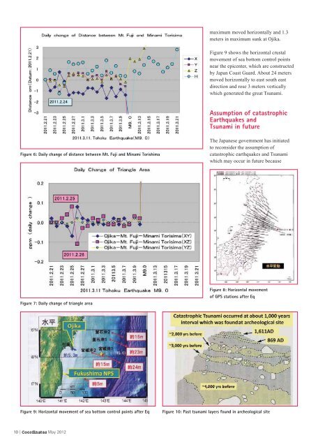
maximum moved horizontally and 1.3<br />
meters in maximum sunk at Ojika.<br />
Figure 9 shows the horizontal crustal<br />
movement of sea bottom control points<br />
near the epicenter, which are constructed<br />
by Japan Coast Guard. About 24 meters<br />
moved horizontally to east south east<br />
direction and rose 3 meters vertically<br />
which generated the great Tsunami.<br />
Assumption of catastrophic<br />
Earthquakes and<br />
Tsunami in future<br />
The Japanese government has initiated<br />
to reconsider the assumption of<br />
catastrophic earthquakes and Tsunami<br />
which may occur in future because<br />
Figure 8: Horizontal movement<br />
of GPS stations after Eq<br />
Figure 9: Horizontal movement of sea bottom control points after Eq Figure 10: Past tsunami layers found in archeological site<br />
10 | <strong>Coordinates</strong> May 2012


