

Download - Coordinates
Download - Coordinates
Download - Coordinates

You also want an ePaper? Increase the reach of your titles
YUMPU automatically turns print PDFs into web optimized ePapers that Google loves.
NEWS – IMAGING<br />
Geostellar teams with GeoEye<br />
GeoEye has announced a strategic<br />
relationship with Geostellar, an innovative<br />
technology company that is transforming<br />
the solar energy industry to supply Earth<br />
imagery, digital surface models and<br />
other mapping data to help Geostellar<br />
dramatically expand its service. Geostellar<br />
has built a breakthrough analytics platform<br />
that automatically determines how quickly<br />
a given property owner can recoup an<br />
investment in solar energy. It has built<br />
solar maps in Washington D.C., Boston,<br />
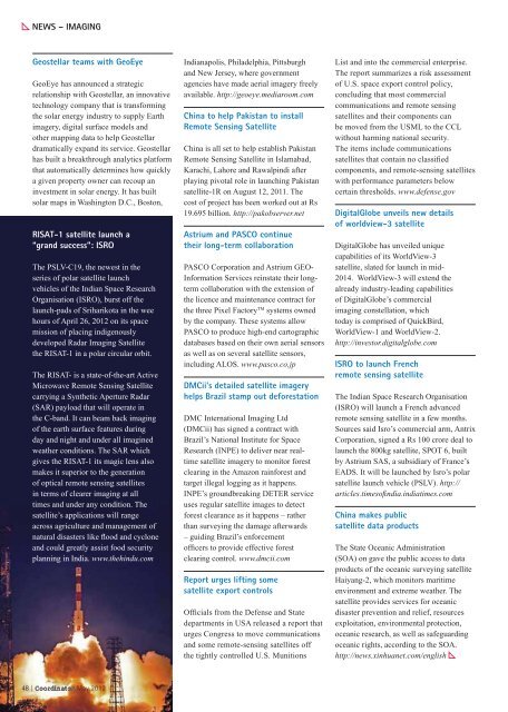
RISAT-1 satellite launch a<br />
“grand success”: ISRO<br />
The PSLV-C19, the newest in the<br />
series of polar satellite launch<br />
vehicles of the Indian Space Research<br />
Organisation (ISRO), burst off the<br />
launch-pads of Sriharikota in the wee<br />
hours of April 26, 2012 on its space<br />
mission of placing indigenously<br />
developed Radar Imaging Satellite<br />
the RISAT-1 in a polar circular orbit.<br />
The RISAT- is a state-of-the-art Active<br />
Microwave Remote Sensing Satellite<br />
carrying a Synthetic Aperture Radar<br />
(SAR) payload that will operate in<br />
the C-band. It can beam back imaging<br />
of the earth surface features during<br />
day and night and under all imagined<br />
weather conditions. The SAR which<br />
gives the RISAT-1 its magic lens also<br />
makes it superior to the generation<br />
of optical remote sensing satellites<br />
in terms of clearer imaging at all<br />
times and under any condition. The<br />
satellite’s applications will range<br />
across agriculture and management of<br />
natural disasters like ood and cyclone<br />
and could greatly assist food security<br />
planning in India. www.thehindu.com<br />
48 | <strong>Coordinates</strong> May 2012<br />
Indianapolis, Philadelphia, Pittsburgh<br />
and New Jersey, where government<br />
agencies have made aerial imagery freely<br />
available. http://geoeye.mediaroom.com<br />
China to help Pakistan to install<br />
Remote Sensing Satellite<br />
China is all set to help establish Pakistan<br />
Remote Sensing Satellite in Islamabad,<br />
Karachi, Lahore and Rawalpindi after<br />
playing pivotal role in launching Pakistan<br />
satellite-1R on August 12, 2011. The<br />
cost of project has been worked out at Rs<br />
19.695 billion. http://pakobserver.net<br />
Astrium and PASCO continue<br />
their long-term collaboration<br />
PASCO Corporation and Astrium GEO-<br />
Information Services reinstate their longterm<br />
collaboration with the extension of<br />
the licence and maintenance contract for<br />
the three Pixel Factory TM systems owned<br />
by the company. These systems allow<br />
PASCO to produce high-end cartographic<br />
databases based on their own aerial sensors<br />
as well as on several satellite sensors,<br />
including ALOS. www.pasco.co.jp<br />
DMCii’s detailed satellite imagery<br />
helps Brazil stamp out deforestation<br />
DMC International Imaging Ltd<br />
(DMCii) has signed a contract with<br />
Brazil’s National Institute for Space<br />
Research (INPE) to deliver near realtime<br />
satellite imagery to monitor forest<br />
clearing in the Amazon rainforest and<br />
target illegal logging as it happens.<br />
INPE’s groundbreaking DETER service<br />
uses regular satellite images to detect<br />
forest clearance as it happens – rather<br />
than surveying the damage afterwards<br />
– guiding Brazil’s enforcement<br />
of cers to provide effective forest<br />
clearing control. www.dmcii.com<br />
Report urges lifting some<br />
satellite export controls<br />
Of cials from the Defense and State<br />
departments in USA released a report that<br />
urges Congress to move communications<br />
and some remote-sensing satellites off<br />
the tightly controlled U.S. Munitions<br />
List and into the commercial enterprise.<br />
The report summarizes a risk assessment<br />
of U.S. space export control policy,<br />
concluding that most commercial<br />
communications and remote sensing<br />
satellites and their components can<br />
be moved from the USML to the CCL<br />
without harming national security.<br />
The items include communications<br />
satellites that contain no classi ed<br />
components, and remote-sensing satellites<br />
with performance parameters below<br />
certain thresholds. www.defense.gov<br />
DigitalGlobe unveils new details<br />
of worldview-3 satellite<br />
DigitalGlobe has unveiled unique<br />
capabilities of its WorldView-3<br />
satellite, slated for launch in mid-<br />
2014. WorldView-3 will extend the<br />
already industry-leading capabilities<br />
of DigitalGlobe’s commercial<br />
imaging constellation, which<br />
today is comprised of QuickBird,<br />
WorldView-1 and WorldView-2.<br />
http://investor.digitalglobe.com<br />
ISRO to launch French<br />
remote sensing satellite<br />
The Indian Space Research Organisation<br />
(ISRO) will launch a French advanced<br />
remote sensing satellite in a few months.<br />
Sources said Isro’s commercial arm, Antrix<br />
Corporation, signed a Rs 100 crore deal to<br />
launch the 800kg satellite, SPOT 6, built<br />
by Astrium SAS, a subsidiary of France’s<br />
EADS. It will be launched by Isro’s polar<br />
satellite launch vehicle (PSLV). http://<br />
articles.timesofi ndia.indiatimes.com<br />
China makes public<br />
satellite data products<br />
The State Oceanic Administration<br />
(SOA) on gave the public access to data<br />
products of the oceanic surveying satellite<br />
Haiyang-2, which monitors maritime<br />
environment and extreme weather. The<br />
satellite provides services for oceanic<br />
disaster prevention and relief, resources<br />
exploitation, environmental protection,<br />
oceanic research, as well as safeguarding<br />
oceanic rights, according to the SOA.<br />
http://news.xinhuanet.com/english


