

Download - Coordinates
Download - Coordinates
Download - Coordinates

Create successful ePaper yourself
Turn your PDF publications into a flip-book with our unique Google optimized e-Paper software.
NEWS – GNSS<br />
$10 bln budgeted for<br />
Glonass to 2020<br />
More than 300 billion rubles ($10.1<br />
billion) have been budgeted to the year<br />
2020 for developing the Glonass satellite<br />
navigation system, Deputy Prime Minister<br />
Vladislav Surkov said recently. He said<br />
the government will make every effort<br />
to lend support to the satellite system<br />
and to develop its capabilities, including<br />
commercial ones, Interfax reported. He<br />
said Russia estimates that the navigation<br />
market in Russia was worth 12 billion<br />
rubles last year. www.themoscowtimes.com<br />
New sensor sought to enable military<br />
missions in GPS-denied areas<br />
Many U.S. Military systems, such as<br />
missiles, rely on the GPS to provide<br />
accurate position, orientation and time<br />
information while in ight. When GPS<br />
is inaccessible, information critical for<br />
navigation must be gathered using the<br />
missile’s on-board sensors. DARPA’s<br />
Chip-Scale Combinatorial Atomic<br />
Navigator (C-SCAN) effort seeks<br />
an atomic inertial sensor to measure<br />
orientation in GPS-denied environments.<br />
Such a sensor would integrate small<br />
size, low power consumption, high<br />
resolution of motion detection and a<br />
fast start up time into a single package.<br />
“Platforms such as missiles rely on GPS<br />
for a variety of information,” explained<br />
Andrei Shkel, DARPA program manager.<br />
“When GPS is not available gyroscopes<br />
provide orientation, accelerometers<br />
provide position and oscillators provide<br />
timing. The new C-SCAN effort focuses<br />
on replacing bulky gyroscopes with a<br />
new inertial measurement unit (IMU)<br />
that is smaller, less expensive due to<br />
foundry fabrication and yields better<br />
performance.” www.darpa.mil<br />
Raytheon and Lockheed Martin<br />
complete integration milestone<br />
Raytheon and Lockheed Martin<br />
successfully completed the rst signi cant<br />
integration milestone between Raytheon’s<br />
GPS Next Generation Operational<br />
Control System (OCX) and Lockheed<br />
Martin’s GPS III satellite system.<br />
The joint Lockheed Martin/Raytheon<br />
team successfully exchanged satellite<br />
commands and telemetry data between the<br />
GPS III satellite simulator in Newtown,<br />
Pa., and the OCX development site in<br />
Aurora, Colo. The integration of the two<br />
sites will facilitate development testing<br />
of the OCX system and allow early<br />
risk reduction testing of the groundsatellite<br />
interface in a test-like-you- y<br />
con guration. www.marketwatch.com<br />
£6 million for UK space<br />
technology industry<br />
As part of the National Space Technology<br />
Programme, the UK Government will<br />
grant nearly GBP 6 million to co-fund<br />
major new research projects that will<br />
develop commercial products and services<br />
using space technology and data from<br />
space-based systems. The grant funding,<br />
from the UK Space Agency and the<br />
Technology Strategy Board, will support<br />
four major research and development<br />
consortium projects. www.bis.gov.uk<br />
Mumbai, India to use GPS to<br />
keep track of city’s trees<br />
BMC’s Tree Authority is nally catching<br />
up with technology: it has decided to<br />
use GPS to keep a track of all trees in<br />
the city and its suburbs. The civic body<br />
hopes that once all trees in the city are<br />
identi ed through their GPS locations, it<br />
will become to easier to track their growth<br />
and identify if any have been illegally<br />
chopped. www.mumbaimirror.com<br />
‘Navipedia’: the reference for<br />
satellite navigation know-how<br />
Satellite navigation is progressing swiftly, in<br />
fact so swiftly that its printed textbooks can’t<br />
keep pace – so ESA has introduced its own<br />
wiki-based information source, Navipedia,<br />
which is also the rst ever ESA technical<br />
wiki opened to the public. With ESA<br />
preparing to launch its next Galileo satellites,<br />
ground-based augmentation expanding<br />
rapidly, all other Global Navigation<br />
Satellite Systems (GNSS) evolving and<br />
new satnav applications emerging every<br />
day, this website’s launch comes at the right<br />
time. Written and reviewed by experts,<br />
there are more than 400 articles on the<br />
site to date covering the fundamental<br />
principles of satellite navigation, how<br />
receivers operate, the various systems<br />
in current or future operation around<br />
the globe and GNSS-related services<br />
and applications. www.esa.int<br />
GNSS receive front-end<br />
modules by Infi neon<br />
In neon Technologies has introduced<br />
a new series of Receive Front-End<br />
Modules for implementation of GNSS<br />
functionality in smart phones and other<br />
handheld devices. The new BGM104xN7<br />
products feature the best noise gure<br />
in the industry, which is a critical<br />
parameter for the performance of a<br />
GNSS receiver. The new modules are<br />
a pin-to-pin compatible upgrade with<br />
the previous generation BGM103xN7,<br />
and thus remain as the world’s smallest<br />
Receive Front-End Modules for this<br />
application, with a package size of just 2.3<br />
x 1.7 x 0.73 mm3. www.infi neon.com.<br />
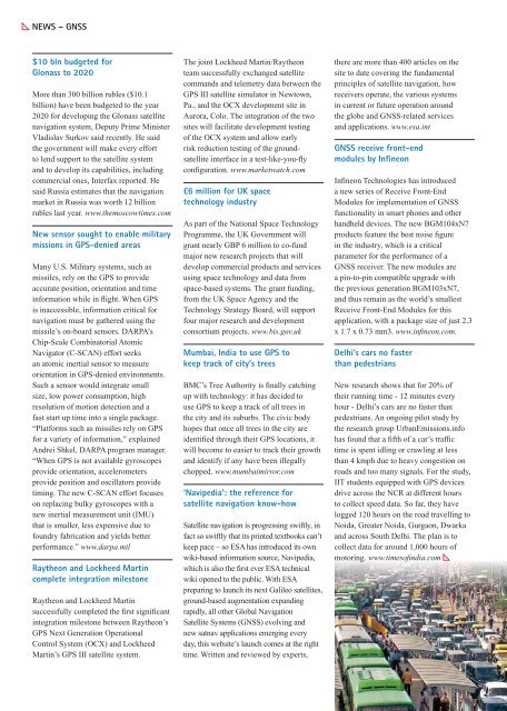
Delhi’s cars no faster<br />
than pedestrians<br />
New research shows that for 20% of<br />
their running time - 12 minutes every<br />
hour - Delhi’s cars are no faster than<br />
pedestrians. An ongoing pilot study by<br />
the research group UrbanEmissions.info<br />
has found that a fth of a car’s traf c<br />
time is spent idling or crawling at less<br />
than 4 kmph due to heavy congestion on<br />
roads and too many signals. For the study,<br />
IIT students equipped with GPS devices<br />
drive across the NCR at different hours<br />
to collect speed data. So far, they have<br />
logged 120 hours on the road travelling to<br />
Noida, Greater Noida, Gurgaon, Dwarka<br />
and across South Delhi. The plan is to<br />
collect data for around 1,000 hours of<br />
motoring. www.timesofi ndia.com


