Biophysical Survey of Mafia Island Marine Reserves
Biophysical Survey of Mafia Island Marine Reserves
Biophysical Survey of Mafia Island Marine Reserves

Create successful ePaper yourself
Turn your PDF publications into a flip-book with our unique Google optimized e-Paper software.
Occasionally, pro<strong>of</strong>ing did not confirm either patch boundaries or patch type.<br />
Consequently, patch types and boundaries were revised. This then directed the selection<br />
<strong>of</strong> locations for further pro<strong>of</strong>ing. This process was repeated until a consensus was<br />
reached; the image was then processed to create a final patch mosaic. Each patch was<br />
assigned a colour to denote the patch type, finally resulting in the delineation <strong>of</strong> the<br />
habitat present in each marine reserve area. It should be noted that a high resolution<br />
satellite image was only available for the purposes <strong>of</strong> this report for NIMR. The images<br />
used for the basis <strong>of</strong> the patch mosaic creation for SIMR and MBIMR were <strong>of</strong> far lower<br />
resolution.<br />
Ground Pro<strong>of</strong>ing Methodology (High Resolution Satellite Image - NIMR)<br />
Ground pro<strong>of</strong>ing transects perpendicular to a series <strong>of</strong> biophysical features were<br />
conducted by snorkel and SCUBA diving. These were designed to provide habitat cross<br />
sections and geo-referenced patch boundaries which could be overlaid onto the high<br />
resolution satellite image. Along these transects, benthic composition data was collected<br />
(Table 2). For SCUBA, benthic composition was recorded every two meters. For snorkel,<br />
percentage composition was recorded for each habitat patch transversed. Habitat patches<br />
were then created and categorised according to the habitat categories described in<br />
Appendix 1. All transects were GPS tracked so they could be overlaid onto the image.<br />
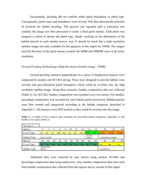
Table 1. A sample <strong>of</strong> dive transect data including the prescribed habitat categories (Appendix 1) and<br />
benthic cover types (Table 2).<br />
TRANSECT 1<br />
Meters 0 2 4 6 8 10 12 14 16 18 20 22 24<br />
Cover Type SC SC SC HM RK SC SC HM MA MA HCBR HCBR HCBR<br />
Habitat Type REEF SLOPE<br />
ALGAL<br />
RIDGE ACROPORA COMM<br />
Meters 26 28 30 32 34 36 38 40 42 44 46 48 50<br />
Cover Type SG SG SG SA SG SG SG SG SG MA SA RB SA<br />
Habitat Type<br />
SEAGRASS<br />
BEDS LAGOONAL -<br />
Additional data were collected by spot checks using snorkel, SCUBA and<br />
percentage composition data using manta tows. Also, benthic composition data were used<br />
from benthic composition data collected from the species survey section <strong>of</strong> this report.