Biophysical Survey of Mafia Island Marine Reserves
Biophysical Survey of Mafia Island Marine Reserves
Biophysical Survey of Mafia Island Marine Reserves

You also want an ePaper? Increase the reach of your titles
YUMPU automatically turns print PDFs into web optimized ePapers that Google loves.
Ground Pro<strong>of</strong>ing Methodology (Low Resolution Satellite Images – SIMR and MBIMR)<br />
A GPS SMB module was used to record spot feature locations and also tracks<br />
along linear features using SCUBA and snorkel. This provided patch boundary locations<br />
that were not apparent on the low resolution image. GPS spot and track information were<br />
then uploaded onto Garmin Mapsource (GM) ready for patch mosaic creation. Additional<br />
data were collected by spot checks using snorkel, SCUBA and percentage composition<br />
data using manta tows. Also, benthic composition data were used from benthic<br />
composition data collected from the species survey section <strong>of</strong> this report.<br />
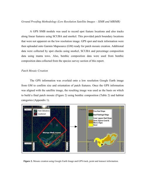
Patch Mosaic Creation<br />
The GPS information was overlaid onto a low resolution Google Earth image<br />
from GM to confirm size and orientation <strong>of</strong> patch features. Once the GPS information<br />
was aligned with the satellite image, the resulting image was used as the basis on which<br />
to build a final patch mosaic (Figure 2) using benthic composition (Table 2) and habitat<br />
categories (Appendix 1).<br />
Figure 2. Mosaic creation using Google Earth Image and GPS track, point and transect information.