

natural Hazards and Climate Change risks - GFDRR
natural Hazards and Climate Change risks - GFDRR
natural Hazards and Climate Change risks - GFDRR

You also want an ePaper? Increase the reach of your titles
YUMPU automatically turns print PDFs into web optimized ePapers that Google loves.
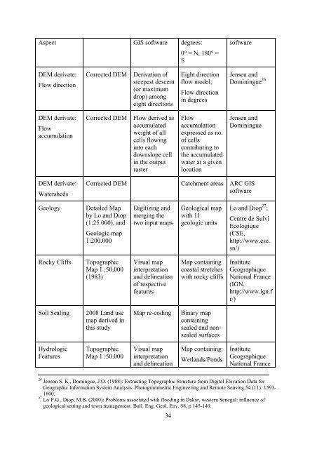
Aspect GIS software degrees:<br />
0° = N, 180° =<br />
S<br />
software<br />
DEM derivate:<br />
Flow direction<br />
Corrected DEM<br />
Derivation of<br />
steepest descent<br />
(or maximum<br />
drop) among<br />
eight directions<br />
Eight direction<br />
flow model;<br />
Flow direction<br />
in degrees<br />
Jensen <strong>and</strong><br />
Dominingue 26<br />
DEM derivate:<br />
Flow<br />
accumulation<br />
Corrected DEM<br />
Flow derived as<br />
accumulated<br />
weight of all<br />
cells flowing<br />
into each<br />
downslope cell<br />
in the output<br />
raster<br />
Flow<br />
accumulation<br />
expressed as no.<br />
of cells<br />
contributing to<br />
the accumulated<br />
water at a given<br />
location<br />
Jensen <strong>and</strong><br />
Dominingue<br />
DEM derivate:<br />
Watersheds<br />
Corrected DEM<br />
Catchment areas ARC GIS<br />
software<br />
Geology<br />
Detailed Map<br />
by Lo <strong>and</strong> Diop<br />
(1:25.000), <strong>and</strong><br />
Geologic map<br />
1:200.000<br />
Digitizing <strong>and</strong><br />
merging the<br />
two input maps<br />
Geological map<br />
with 11<br />
geologic units<br />
Lo <strong>and</strong> Diop 27 ;<br />
Centre de Suivi<br />
Ecologique<br />
(CSE,<br />
http://www.cse.<br />
sn/)<br />
Rocky Cliffs<br />
Topographic<br />
Map 1 :50.000<br />
(1983)<br />
Visual map<br />
interpretation<br />
<strong>and</strong> delineation<br />
of respective<br />
features<br />
Map containing<br />
coastal stretches<br />
with rocky cliffs<br />
Institute<br />
Geographique<br />
National France<br />
(IGN,<br />
http://www.ign.f<br />
r/)<br />
Soil Sealing<br />
2008 L<strong>and</strong> use<br />
map derived in<br />
this study<br />
Map re-coding<br />
Binary map<br />
containing<br />
sealed <strong>and</strong> nonsealed<br />
surfaces<br />
Hydrologic<br />
Features<br />
Topographic<br />
Map 1 :50.000<br />
Visual map<br />
interpretation<br />
<strong>and</strong> delineation<br />
Map containing:<br />
Wetl<strong>and</strong>s/Ponds<br />
Institute<br />
Geographique<br />
National France<br />
26 Jenson S. K., Domingue, J.O. (1988): Extracting Topographic Structure from Digital Elevation Data for<br />
Geographic Information System Analysis. Photogrammetric Engineering <strong>and</strong> Remote Sensing 54 (11): 1593-<br />
1600.<br />
27 Lo , P.G., Diop, M.B. (2000): Problems associated with flooding in Dakar, western Senegal: influence of<br />
geological setting <strong>and</strong> town management. Bull. Eng. Geol. Env. 58, p 145-149.<br />
34


