

natural Hazards and Climate Change risks - GFDRR
natural Hazards and Climate Change risks - GFDRR
natural Hazards and Climate Change risks - GFDRR

Create successful ePaper yourself
Turn your PDF publications into a flip-book with our unique Google optimized e-Paper software.
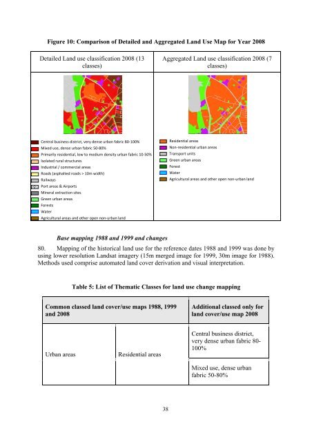
Figure 10: Comparison of Detailed <strong>and</strong> Aggregated L<strong>and</strong> Use Map for Year 2008<br />
Detailed L<strong>and</strong> use classification 2008 (13<br />
classes)<br />
Aggregated L<strong>and</strong> use classification 2008 (7<br />
classes)<br />
Central business district, very dense urban fabric 80‐100%<br />
Mixed use, dense urban fabric 50‐80%<br />
Primarily residential, low to medium density urban fabric 10‐50%<br />
Isolated rural structures<br />
Industrial / commercial areas<br />
Roads (asphalted roads > 10m width)<br />
Railways<br />
Port areas & Airports<br />
Mineral extraction sites<br />
Green urban areas<br />
Forests<br />
Water<br />
Agricultural areas <strong>and</strong> other open non‐urban l<strong>and</strong><br />
Residential areas<br />
Non‐residential urban areas<br />
Transport units<br />
Green urban areas<br />
Forest<br />
Water<br />
Agricultural areas <strong>and</strong> other open non‐urban l<strong>and</strong><br />
Base mapping 1988 <strong>and</strong> 1999 <strong>and</strong> changes<br />
80. Mapping of the historical l<strong>and</strong> use for the reference dates 1988 <strong>and</strong> 1999 was done by<br />
using lower resolution L<strong>and</strong>sat imagery (15m merged image for 1999, 30m image for 1988).<br />
Methods used comprise automated l<strong>and</strong> cover derivation <strong>and</strong> visual interpretation.<br />
Table 5: List of Thematic Classes for l<strong>and</strong> use change mapping<br />
Common classed l<strong>and</strong> cover/use maps 1988, 1999<br />
<strong>and</strong> 2008<br />
Additional classed only for<br />
l<strong>and</strong> cover/use map 2008<br />
Urban areas<br />
Residential areas<br />
Central business district,<br />
very dense urban fabric 80-<br />
100%<br />
Mixed use, dense urban<br />
fabric 50-80%<br />
38


