Lateglacial and early Holocene vegetation ... - geo.edu.ro
Lateglacial and early Holocene vegetation ... - geo.edu.ro
Lateglacial and early Holocene vegetation ... - geo.edu.ro

You also want an ePaper? Increase the reach of your titles
YUMPU automatically turns print PDFs into web optimized ePapers that Google loves.
L. Bj .orkman et al. / Quaternary Science Reviews 21 (2002) 1039–1059 1041<br />
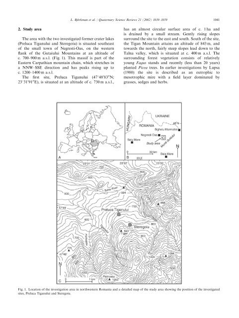
2. Study area<br />
The area with the two investigated former crater lakes<br />
(Preluca Tiganului <st<strong>ro</strong>ng>and</st<strong>ro</strong>ng> Steregoiu) is situated southeast<br />
of the small town of Negresti-Oas, on the western<br />
flank of the Gutaiului Mountains at an altitude of<br />
c. 700–900 ma.s.l. (Fig. 1). This massif is part of the<br />
Eastern Carpathian mountain chain, which stretches in<br />
a NNW–SSE direction <st<strong>ro</strong>ng>and</st<strong>ro</strong>ng> has peaks rising up to<br />
c. 1200–1400 ma.s.l.<br />
The first site, Preluca Tiganului (47148 0 83 00 N;<br />
23131 0 91 00 E), is situated at an altitude of c. 730 ma.s.l.,<br />
has an almost circular surface area of c. 1 ha <st<strong>ro</strong>ng>and</st<strong>ro</strong>ng><br />
is drained by a small stream. Gently rising slopes<br />
sur<strong>ro</strong>und the site to the east <st<strong>ro</strong>ng>and</st<strong>ro</strong>ng> south. South of the site,<br />
the Tigan Mountain attains an altitude of 843 m, <st<strong>ro</strong>ng>and</st<strong>ro</strong>ng><br />
towards the north, fairly steep slopes lead down to the<br />
Talna valley, which is situated at c. 400 ma.s.l. The<br />
sur<strong>ro</strong>unding forest <st<strong>ro</strong>ng>vegetation</st<strong>ro</strong>ng> consists of relatively<br />
young Fagus st<st<strong>ro</strong>ng>and</st<strong>ro</strong>ng>s <st<strong>ro</strong>ng>and</st<strong>ro</strong>ng> recently (less than 20 years)<br />
planted Picea trees. In earlier investigations by Lupsa<br />
(1980) the site is described as an eut<strong>ro</strong>phic to<br />
mesot<strong>ro</strong>phic mire with a field layer dominated by<br />
grasses, sedges <st<strong>ro</strong>ng>and</st<strong>ro</strong>ng> herbs.<br />
Fig. 1. Location of the investigation area in northwestern Romania <st<strong>ro</strong>ng>and</st<strong>ro</strong>ng> a detailed map of the study area showing the position of the investigated<br />
sites, Preluca Tiganului <st<strong>ro</strong>ng>and</st<strong>ro</strong>ng> Steregoiu.