Lateglacial and early Holocene vegetation ... - geo.edu.ro
Lateglacial and early Holocene vegetation ... - geo.edu.ro
Lateglacial and early Holocene vegetation ... - geo.edu.ro

Create successful ePaper yourself
Turn your PDF publications into a flip-book with our unique Google optimized e-Paper software.
1042<br />
L. Bj .orkman et al. / Quaternary Science Reviews 21 (2002) 1039–1059<br />
The second site, Steregoiu (47148 0 48 00 N; 23132 0 41 00 E),<br />
is situated at a somewhat higher altitude than Preluca<br />
Tiganului, at c. 790 ma.s.l. It has a <strong>ro</strong>ughly elongated<br />
surface (c. 50 100 m) of c. 0.5 ha. The site is drained by<br />
a small stream towards the east. It is sur<strong>ro</strong>unded by<br />
fairly steep slopes to the south <st<strong>ro</strong>ng>and</st<strong>ro</strong>ng> west, where a small<br />
streamenters the basin. Towards the northeast fairly<br />
steep slopes lead down to the Talna valley. The<br />
sur<strong>ro</strong>unding <st<strong>ro</strong>ng>vegetation</st<strong>ro</strong>ng> is dominated by young Fagus<br />
(app<strong>ro</strong>ximately 30–50 years) <st<strong>ro</strong>ng>and</st<strong>ro</strong>ng> Picea st<st<strong>ro</strong>ng>and</st<strong>ro</strong>ng>s. The site<br />
can be described as a eut<strong>ro</strong>phic to mesot<strong>ro</strong>phic mire<br />
with a field layer dominated by grasses, sedges <st<strong>ro</strong>ng>and</st<strong>ro</strong>ng><br />
herbs.<br />
There are no climate records directly available for<br />
the study area, but records f<strong>ro</strong>mweather stations<br />
in Satu Mare <st<strong>ro</strong>ng>and</st<strong>ro</strong>ng> Baia Mare (Fig. 1), <st<strong>ro</strong>ng>and</st<strong>ro</strong>ng> f<strong>ro</strong>mthe<br />
eastern (Ocna Sugutag) <st<strong>ro</strong>ng>and</st<strong>ro</strong>ng> northern (Sighetu Marmatiei)<br />
part of the Gutaiului Mountains, may be used<br />
as a good app<strong>ro</strong>ximation. Highest mean annual air<br />
temperatures of 9.51C are recorded at Satu Mare<br />
<st<strong>ro</strong>ng>and</st<strong>ro</strong>ng> Baia Mare, while temperatures range slightly<br />
lower at 7.81C <st<strong>ro</strong>ng>and</st<strong>ro</strong>ng> 8.51C east <st<strong>ro</strong>ng>and</st<strong>ro</strong>ng> north of the<br />
mountain chain. Mean annual precipitation is lowest<br />
in Satu Mare (c. 600 mm). It rises towards the east<br />
to c. 850 mm a<strong>ro</strong>und Baia Mare <st<strong>ro</strong>ng>and</st<strong>ro</strong>ng> then decreases<br />
slightly to c. 700 <st<strong>ro</strong>ng>and</st<strong>ro</strong>ng> 750 mm towards the east <st<strong>ro</strong>ng>and</st<strong>ro</strong>ng> the<br />
north.<br />
F<strong>ro</strong>ma <st<strong>ro</strong>ng>geo</st<strong>ro</strong>ng>logical point of view, the area represents<br />
the northwestern termination of a volcanic arc, situated<br />
in the inner part of the Eastern Carpathians. The<br />
volcanic activity in this region took place during the<br />
Late Pliocene, generating a large range of intermediary<br />
<st<strong>ro</strong>ng>and</st<strong>ro</strong>ng> acidic <strong>ro</strong>cks, in particular dacites, <st<strong>ro</strong>ng>and</st<strong>ro</strong>ng>esites <st<strong>ro</strong>ng>and</st<strong>ro</strong>ng><br />
rhyolites (Borcos et al., 1979). The main bed<strong>ro</strong>ck type in<br />
the study area is <st<strong>ro</strong>ng>and</st<strong>ro</strong>ng>esite. There is no published<br />
information about Quaternary deposits in the area,<br />
but our own field observations in, for instance <strong>ro</strong>ad cuts,<br />
indicate that most of the soil cover is derived f<strong>ro</strong>m slope<br />
p<strong>ro</strong>cesses. It is also assumed that alpine glaciers did not<br />
reach below 1800 ma.s.l. in the Carpathians during the<br />
Last Glacial Maximum (LGM) (Balteanu et al., 1998).<br />
The low elevation of the Gutaiului Mountains makes it<br />
unlikely that the area was glaciated during the<br />
Weichselian, but is however, likely that the area has<br />
been subjected to periglacial conditions during the<br />
LGM.<br />
3. Methods<br />
Sediment cores were taken in the centre of each basin<br />
in May 1999, where the organogenic deposits were<br />
thickest (Table 1). Coring was performed with a<br />
strengthened Russian corer (diameter: 5 cm, length:<br />
1 m), <st<strong>ro</strong>ng>and</st<strong>ro</strong>ng> each core was taken with an overlap of<br />
50 cm, in order to obtain enough material for analyses.<br />
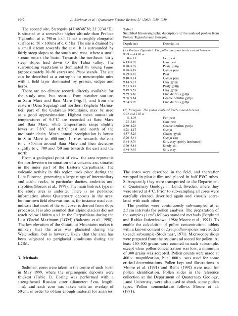
Table 1<br />
Simplified lithostratigraphic descriptions of the analysed p<strong>ro</strong>files f<strong>ro</strong>m<br />
Preluca Tiganului <st<strong>ro</strong>ng>and</st<strong>ro</strong>ng> Steregoiu<br />
Depth (m)<br />
Description<br />
(A) Preluca Tiganului. The pollen analysed levels extend between<br />
9.89 <st<strong>ro</strong>ng>and</st<strong>ro</strong>ng> 4.01 m<br />
0–6.13 Fen peat<br />
6.13–8.70 Carr peat<br />
8.70–8.78 Peaty gyttja<br />
8.78–8.89 Gyttja peat<br />
8.89–9.10 Peat<br />
9.10–9.14 Gyttja peat<br />
9.14–9.33 Clay gyttja<br />
9.33–9.49 Peaty gyttja<br />
9.49–9.59 Clay gyttja<br />
9.59–9.68 Fine detritus gyttja<br />
9.68–9.84 Coarse detritus gyttja<br />
9.84–9.90 Fine detritus gyttja<br />
(B) Steregoiu. The pollen analysed levels extend between<br />
5.92 <st<strong>ro</strong>ng>and</st<strong>ro</strong>ng> 2.83 m<br />
0–1.25 Fen peat<br />
1.25–2.80 Carr peat<br />
2.80–4.28 Coarse detritus gyttja<br />
4.28–4.57 Gyttja<br />
4.57–5.26 Clayey gyttja<br />
5.26–5.44 Gyttja clay<br />
5.44–5.70 Silty clay (partly laminated)<br />
5.70–5.84 S<st<strong>ro</strong>ng>and</st<strong>ro</strong>ng>y silt<br />
5.84–5.92 Silty clay<br />
The cores were described in the field, <st<strong>ro</strong>ng>and</st<strong>ro</strong>ng> thereafter<br />
wrapped in plastic film<st<strong>ro</strong>ng>and</st<strong>ro</strong>ng> placed in half PVC tubes.<br />
Subsequently they were transported to the Department<br />
of Quaternary Geology in Lund, Sweden, where they<br />
were stored at 41C. Prior to sub-sampling all cores were<br />
carefully cleaned, described again <st<strong>ro</strong>ng>and</st<strong>ro</strong>ng> visually correlated<br />
with each other.<br />
The p<strong>ro</strong>files were continuously sub-sampled at c.<br />
2.5 cmintervals for pollen analysis. The preparation of<br />
the samples (1 cm 3 ) follows st<st<strong>ro</strong>ng>and</st<strong>ro</strong>ng>ard methods (Berglund<br />
<st<strong>ro</strong>ng>and</st<strong>ro</strong>ng> Ralska-Jasiewiczowa, 1986; Moore et al., 1991). To<br />
enable the calculation of pollen concentration, tablets<br />
with a known content of Lycopodium spores were added<br />
to each subsample (Stockmarr, 1971). Mic<strong>ro</strong>scope slides<br />
were prepared f<strong>ro</strong>mthe residue <st<strong>ro</strong>ng>and</st<strong>ro</strong>ng> scored for pollen. At<br />
least 450–500 grains were counted in each subsample,<br />
except when pollen concentration was low, a minimum<br />
of 300 grains was accepted. Pollen counts were made at<br />
400 magnification, but 1000 was used for some<br />
critical determinations. Pollen keys <st<strong>ro</strong>ng>and</st<strong>ro</strong>ng> illustrations in<br />
Moore et al. (1991) <st<strong>ro</strong>ng>and</st<strong>ro</strong>ng> Reille (1992) were used for<br />
pollen identification. Pollen slides in the reference<br />
collection at the Department of Quaternary Geology,<br />
Lund University, were also used to check some pollen<br />
types. Pollen nomenclature follows Moore et al.<br />
(1991).