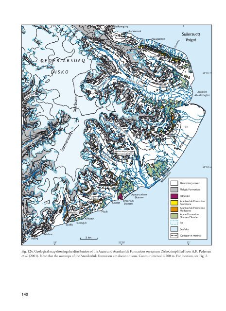
Illukunnguaq Ujarasussuk Nuugaarsuk Akunneq Sullorsuaq Vaigat Q E Q E R T A R S U A Q Inngigissoq Pingu D I S K O 69°45’ Sorte Hak Storbræen Frederik Lange Dal Sullorsuaq Kv<strong>and</strong>alen Aqajaruata Qaqqaa Aqajarua Mudderbugten Daugaard-Jensen Dal Sermersuaq Laksedalen Killussaatsut Kuuat Blåbærdalen K uk Qaamasoq Akuliarutsip Qaqqaa Skorstensfjeldet Gule Ryg Flakkerhuk t 69°30’ Killussaatsut Quaternary cover Maligât Formation Siniffik Kuuk Qaamasoq Tuapaat Qaqqaat Marraat Nuuk Killuusat Innanguit Illunnguaq Tuapaat Aamaruutissat Skansen Innaarsuit Skansen Intrusion Atanikerluk Formation S<strong>and</strong>stone Atanikerluk Formation Mudstone Atane Formation Skansen Member Ice Sea/lake Assoq Niuluut 53° 5 km 52°30’ 500 Contour in metres 52° Fig. 124. <strong>Geological</strong> map showing the distribution <strong>of</strong> the Atane <strong>and</strong> Atanikerluk Formations on eastern Disko, simplified from A.K. Pedersen et al. (2001). Note that the outcrops <strong>of</strong> the Atanikerluk Formation are discontinuous. Contour interval is 200 m. For location, see Fig. 2. 140
In detail, however, the boundary between the Atanikerluk Formation <strong>and</strong> the volcanic formations can be complex, hyaloclastite breccias <strong>and</strong> invasive lavas interdigitating with the sedimentary succession. These sediments, interstratified locally with the lowermost volcanic layers, are intimately associated with the uppermost Nuussuaq Group strata <strong>and</strong> are thus referred to the Atanikerluk Formation where demonstrably related to an interdigitating volcanic–sediment facies front (Figs 17, 131). Two new formations, the Quikavsak Formation <strong>and</strong> the Atanikerluk Formation, replace the ‘Upper Atani kerd - luk Formation’ <strong>of</strong> Nordenskiöld (1871), Troelsen (<strong>19</strong>56) <strong>and</strong> Koch (<strong>19</strong>59). The term ‘Upper Atanikerdluk For - mation’ dates back to Nordenskiöld (1871), who used this name for the beds (Öfre Atanekerdluklagren) containing the upper flora in the Atanikerluk area. The plant fossils occur in concretions that are dark grey on fresh surfaces but weather to a dark red colour (Nordenskiöld 1871 pp. 1051–52). Koch (<strong>19</strong>59) reported that these concretions contain the Upper Atanikerdluk A flora <strong>of</strong> Heer (1883a, b) <strong>and</strong> that they occur in his Quikavsak Member, i.e. the Quikavsak Formation <strong>of</strong> the present paper. The name Atanikerluk Formation is proposed because it does not imply the existence <strong>of</strong> a ‘Lower Atanikerd luk Formation’. Although a Lower Atanikerdluk Flora was mentioned by Heer (1868), this originated from the Atane Formation as recognised as early as 1871 by Nordenskiöld. Koch (<strong>19</strong>59) subdivided the Upper Atanikerdluk Formation into five members on Nuussuaq (Fig. 123) but attempted no subdivision <strong>of</strong> the formation on Disko. His Quikavsak Member is here established as the Qui - kavsak Formation. Two <strong>of</strong> Koch’s members on Nuus - suaq are retained (the Naujât <strong>and</strong> Umiussat Members), whereas the Aussivik <strong>and</strong> Point 976 Members are ab<strong>and</strong>oned <strong>and</strong> the sediments are referred to the new Assoq Member. The reason for this is that the Aussivik <strong>and</strong> Point 976 Members are only found in a very small area <strong>of</strong> south-eastern Nuussuaq (A.K. Pedersen et al. 2007b). On Disko, a subdivision into five members is proposed (the Naujât, Akunneq, Pingu, Umiussat, <strong>and</strong> Assoq Mem - bers; Fig. 123). The subdivision <strong>of</strong> the Atanikerluk Formation into five members reflects the dramatic palaeogeographic changes that accompanied the intense volcanic activity. Name. The formation is named after the Atanikerluk peninsula formed by a sill on the south coast <strong>of</strong> Nuussuaq (Fig. 40). The name was formerly spelled Atanekerdluk or Atanikerdluk. Distribution. The Atanikerluk Formation is known on south-east Nuussuaq (Saqqaqdalen, Atanikerluk, Kingit - toq, Paatuut, <strong>and</strong> Ataata Kuua), on central Nuussuaq (Nassaat <strong>and</strong> locally in Aaffarsuaq), on eastern Disko (Assoq, Tuapaat Qaqqaat, Gule Ryg, Pingu, Nuugaarsuk, Frederik Lange Dal) <strong>and</strong> central Disko (Daugaard Jensen Dal <strong>and</strong> Sorte Hak; Figs 2, 40, 124). In the Atanikerluk area, the formation was mapped in great detail by Koch & Pedersen (<strong>19</strong>60). Paleocene siliciclastic sediments are also present on Svartenhuk Halvø, where they are overlain by the volcanic Vaigat <strong>and</strong> Svartenhuk Formations (J.G. Larsen, personal communication 2008). These sediments remain unstudied in detail <strong>and</strong> the distribution <strong>of</strong> marine pre-volcanic, marine synvolcanic <strong>and</strong> nonmarine synvolcanic deposits is not known at present. In the future, Paleocene non-marine, synvolcanic sediments on Svartenhuk Halvø may be established as one or more members within the Atanikerluk Formation. Type section. The section in the south-facing slope between Atanikerluk <strong>and</strong> Tartunaq on south-east Nuussuaq is retained as the type section (Figs 125, 126) for the Atanikerluk Formation. This was described in detail by Koch (<strong>19</strong>59), who defined type sections for several members <strong>of</strong> the formation in this area. The type section is located at 70° 03.63´N, 52°13.53´W. Reference sections. Reference sections <strong>of</strong> the Atanikerluk Formation are found at Kingittoq, at Pingu <strong>and</strong> in the Tuapaat area (Figs 7, 132, 140). The stratigraphic succession in north-east Disko has been compiled from the (mainly sedimentary) sections on both sides <strong>of</strong> Akunneq <strong>and</strong> the volcanic succession at Aqajaruata Qaqqaa, south <strong>of</strong> Akunneq (A.K. Pedersen et al. 2005) (Figs 124, 131). Thickness. The Atanikerluk Formation is up to 500 m thick in a composite section, but individual outcrops reach thicknesses <strong>of</strong> c. 400 m (Pingu), c. 300 m (Kingittoq, Atanikerluk) <strong>and</strong> 200–250 m (Saqqaqdalen) (Figs 126, 128). At Tuapaat Qaqqaat, the thickness is difficult to measure due to l<strong>and</strong>slides <strong>and</strong> interbedding <strong>of</strong> sediments <strong>and</strong> invasive lava flows (Fig. 140). Invasive lava flows are discussed below under ‘Lithology’. Lithology. The Atanikerluk Formation comprises mudstones, heterolithic s<strong>and</strong>stones, <strong>and</strong> fine-grained, loosely cemented s<strong>and</strong>stones. Mudstones are dominant in the Naujât <strong>and</strong> Pingu Members (Fig. 127) <strong>and</strong> in the lower part <strong>of</strong> the Assoq Member, whereas very friable s<strong>and</strong>stones characterise the Akunneq <strong>and</strong> Umiussat Members <strong>and</strong> the upper part <strong>of</strong> the Assoq Member. On a regional 141