- Page 1 and 2: GEOLOGICAL SURVEY OF DENMARK AND GR
- Page 4 and 5: Contents Abstract . . . . . . . . .
- Page 7 and 8: Preface The onshore Cretaceous-Pale
- Page 9 and 10: Introduction The Nuussuaq Basin bel
- Page 11 and 12: chemistry of the Nuussuaq Basin hav
- Page 13 and 14: Fig. 5. Plant fossils from the Atan
- Page 15 and 16: Peak 2010 m Peak 1900 m Peak 1760 m
- Page 17 and 18: A lithostratigraphy for the marine
- Page 19 and 20: to provide further funding for stud
- Page 21 and 22: DGR Geological setting As a result
- Page 23 and 24: TSS 8 Agatdal Fm Eqalulik Fm Kangil
- Page 25 and 26: A Svartenhuk Halvø 50 km B Hinterl
- Page 27 and 28: Nuussuaq Group new group History. T
- Page 29 and 30: ley (Figs 2, 40, 65). The section a
- Page 31 and 32: Central Nuussuaq Agatdalen South co
- Page 33 and 34: 3 10 4 6 5 Qorlortorssuaq Slibesten
- Page 35 and 36: volcanic sediments are referred to
- Page 37 and 38: Fig. 20. View from Uummannaq toward
- Page 39 and 40: In the Kuuk area, the sediments ove
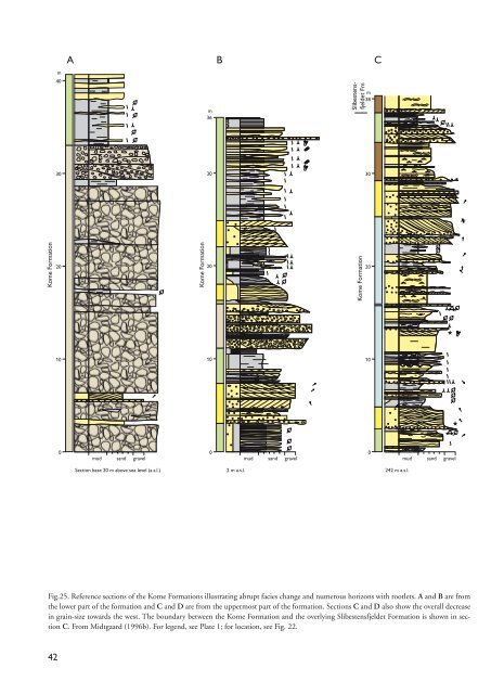
- Page 41: m m 15 14 14 13 12 11 10 9 8 7 6 5
- Page 45 and 46: Fig. 28. Reference locality of the
- Page 47 and 48: Vaigat Fm Vesterfjeld Slibestensfje
- Page 49 and 50: Gilbert delta in the Ikorfat area (
- Page 51 and 52: 150 300 450 100 250 400 m 550 50 20
- Page 53 and 54: Fig. 36. Outcrop of the Upernivik N
- Page 55 and 56: Correlation. The Upernivik Næs flo
- Page 57 and 58: 12’ 09’ 15’ 06’ 03’ Saqqa
- Page 59 and 60: m 0 GGU 247801 200 400 247815 ★
- Page 61 and 62: wave-rippled sand streaked mudstone
- Page 63 and 64: the formation in the marine mudston
- Page 65 and 66: d d Fig. 47. Type locality of the S
- Page 67 and 68: Fig. 49. Cross-bedded medium- to co
- Page 69 and 70: and Qaarsut (Fig. 22). Its wider di
- Page 71 and 72: Fig. 52. Two closely spaced section
- Page 73 and 74: Type section. The type section of t
- Page 75 and 76: Fig. 56. Delta front succession of
- Page 77 and 78: Fig. 59. The Kingittoq Member at Ki
- Page 79 and 80: sh L sh ch delta front Vaigat Forma
- Page 81 and 82: Fig. 63. Type locality of the Itivn
- Page 83 and 84: 782 Quaternary cover 54° 888 Malig
- Page 85 and 86: Kuugannguaq-Qunnilik Fault and is o
- Page 87 and 88: and include clasts of intraformatio
- Page 89 and 90: deposited in a base-of-slope and ba
- Page 91 and 92: VK 53°30’ 53°15’ Niaqornat Tu
- Page 93 and 94:
Umiivik-1 m Overburden ★ ★ No p
- Page 95 and 96:
76). Heavily bioturbated interbedde
- Page 97 and 98:
Fig. 78. Type locality of the Kussi
- Page 99 and 100:
A B Itilli Formation Kussinerujuk M
- Page 101 and 102:
160 140 120 100 Vaigat Formation Eq
- Page 103 and 104:
Fig. 85. Mudstones and conglomerati
- Page 105 and 106:
Fig. 87. Type section of the Kangil
- Page 107 and 108:
m 150 140 130 120 110 100 90 Kangil
- Page 109 and 110:
channellised, high-density currents
- Page 111 and 112:
Thickness. The Annertuneq Conglomer
- Page 113 and 114:
Fig. 96. A: Type locality of the Oy
- Page 115 and 116:
On Svartenhuk Halvø, on the east s
- Page 117 and 118:
Fig. 100. Reference locality of the
- Page 119 and 120:
Tupaasat Member Atane Formation Fig
- Page 121 and 122:
ever, have a fluvio-lacustrine orig
- Page 123 and 124:
etween Tupaasat and Nuuk Qiterleq a
- Page 125 and 126:
Vaigat Formation sill Quikavsak For
- Page 127 and 128:
Fig. 112. The sharp boundary betwee
- Page 129 and 130:
Agatdal Formation Eqalulik Formatio
- Page 131 and 132:
Fig. 116. Basal conglomerate unit o
- Page 133 and 134:
heterolithic deposits of the Kangil
- Page 135 and 136:
GANE#1 Vaigat Fm Anaanaa Mb m Hyalo
- Page 137 and 138:
Fig. 121. Well reference section of
- Page 139 and 140:
Pedersen 1978). The beds are usuall
- Page 141 and 142:
In detail, however, the boundary be
- Page 143 and 144:
Fig. 126. Composite type section of
- Page 145 and 146:
m m 240 340 m Pingu Member 230 230
- Page 147 and 148:
Naujât Member Atane Formation, Kin
- Page 149 and 150:
The TOC [Total Organic Carbon] cont
- Page 151 and 152:
Fig. 133. Correlation of the member
- Page 153 and 154:
Fig. 135. Type locality of the Ping
- Page 155 and 156:
Fig. 137. Lower, sharp boundary of
- Page 157 and 158:
m 130 125 110 t t invasive lava low
- Page 159 and 160:
Fig. 141. Upper part of the Assoq M
- Page 161 and 162:
Brown, R. 1875: Geological notes on
- Page 163 and 164:
a rosetted spreite trace fossil: Da
- Page 165 and 166:
ing bark from the Nûgssuaq peninsu
- Page 167 and 168:
1998: The syn-volcanic Naajaat lake
- Page 169 and 170:
Appendix: Place names and localitie
- Page 171:
Place name Place name P Paatuut sou