

Geological Survey of Denmark and Greenland Bulletin 19 ... - Geus
Geological Survey of Denmark and Greenland Bulletin 19 ... - Geus
Geological Survey of Denmark and Greenland Bulletin 19 ... - Geus

Create successful ePaper yourself
Turn your PDF publications into a flip-book with our unique Google optimized e-Paper software.
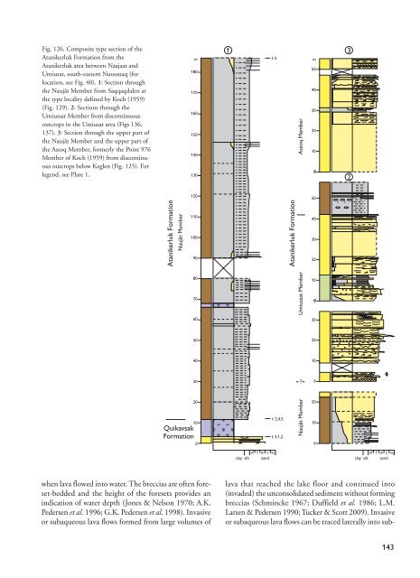
Fig. 126. Composite type section <strong>of</strong> the<br />
Atanikerluk Formation from the<br />
Atanikerluk area between Naajaat <strong>and</strong><br />
Umiusat, south-eastern Nuussuaq (for<br />
location, see Fig. 40). 1: Section through<br />
the Naujât Member from Saqqaqdalen at<br />
the type locality defined by Koch (<strong>19</strong>59)<br />
(Fig. 129). 2: Sections through the<br />
Umiussat Member from discontinuous<br />
outcrops in the Umiusat area (Figs 136,<br />
137). 3: Section through the upper part <strong>of</strong><br />
the Naujât Member <strong>and</strong> the upper part <strong>of</strong><br />
the Assoq Member, formerly the Point 976<br />
Member <strong>of</strong> Koch (<strong>19</strong>59) from discontinuous<br />
outcrops below Keglen (Fig. 125). For<br />
legend, see Plate 1.<br />
Atanikerluk Formation<br />
Naujât Member<br />
m<br />
180<br />
170<br />
160<br />
150<br />
140<br />
130<br />
120<br />
110<br />
100<br />
90<br />
80<br />
70<br />
60<br />
50<br />
40<br />
30<br />
20<br />
10<br />
Quikavsak<br />
Formation<br />
0<br />
1 3<br />
t 5<br />
t 2,4,5<br />
t 3,1,2<br />
Atanikerluk Formation<br />
Naujât Member Umiussat Member<br />
Assoq Member<br />
?<br />
m<br />
50<br />
40<br />
30<br />
20<br />
10<br />
0<br />
50<br />
* *<br />
40<br />
30<br />
20<br />
10<br />
0<br />
30<br />
20<br />
10<br />
0<br />
20<br />
10<br />
0<br />
2<br />
vf<br />
clay silt<br />
f m c vc<br />
s<strong>and</strong><br />
vf<br />
clay silt<br />
f m c vc<br />
s<strong>and</strong><br />
when lava flowed into water. The breccias are <strong>of</strong>ten foreset-bedded<br />
<strong>and</strong> the height <strong>of</strong> the foresets provides an<br />
indication <strong>of</strong> water depth (Jones & Nelson <strong>19</strong>70; A.K.<br />
Pedersen et al. <strong>19</strong>96; G.K. Pedersen et al. <strong>19</strong>98). Invasive<br />
or subaqueous lava flows formed from large volumes <strong>of</strong><br />
lava that reached the lake floor <strong>and</strong> continued into<br />
(invaded) the unconsolidated sediment without forming<br />
breccias (Schmincke <strong>19</strong>67; Duffield et al. <strong>19</strong>86; L.M.<br />
Larsen & Pedersen <strong>19</strong>90; Tucker & Scott 2009). Invasive<br />
or subaqueous lava flows can be traced laterally into sub-<br />
143


