

archaeological survey of peripheral settlements on the ... - asprs
archaeological survey of peripheral settlements on the ... - asprs
archaeological survey of peripheral settlements on the ... - asprs

Create successful ePaper yourself
Turn your PDF publications into a flip-book with our unique Google optimized e-Paper software.
meter wide st<strong>on</strong>e lined and surfaced linear feature was discovered 60.0 meters southwest <str<strong>on</strong>g>of</str<strong>on</strong>g> Structure 20. We were<br />
able to trace this feature <strong>on</strong> <strong>the</strong> surface for a distance <str<strong>on</strong>g>of</str<strong>on</strong>g> 55 meters to <strong>the</strong> southwest toward a porti<strong>on</strong> <str<strong>on</strong>g>of</str<strong>on</strong>g> <strong>the</strong> site<br />
occupied by several structures and an architectural group. If extended southwest toward Group D and nor<strong>the</strong>ast for<br />
60 meters al<strong>on</strong>g its current azimuth, this feature would link Structure 20 and M<strong>on</strong>ument 4 to Group D. We are<br />
reluctant to label <strong>the</strong> feature a causeway until excavati<strong>on</strong>s can be completed. Structure 29 is situated 50 meters<br />
northwest <str<strong>on</strong>g>of</str<strong>on</strong>g> <strong>the</strong> central plaza. The orientati<strong>on</strong> <str<strong>on</strong>g>of</str<strong>on</strong>g> this structure and its strategic positi<strong>on</strong> perched above Group A<br />
suggests that it might have been a functi<strong>on</strong>al part <str<strong>on</strong>g>of</str<strong>on</strong>g> <strong>the</strong> central elite architectural complex. A group <str<strong>on</strong>g>of</str<strong>on</strong>g> four low<br />
mounds were located 100 meters southwest <str<strong>on</strong>g>of</str<strong>on</strong>g> Structure 29 and mapped as well.<br />
A total <str<strong>on</strong>g>of</str<strong>on</strong>g> 67 low domestic mounds were mapped outside <strong>the</strong> central core at Dos Quebradas. The largest<br />
c<strong>on</strong>centrati<strong>on</strong> is located south <str<strong>on</strong>g>of</str<strong>on</strong>g> structure 20. Each mound was associated with a c<strong>on</strong>centrati<strong>on</strong> <str<strong>on</strong>g>of</str<strong>on</strong>g> cultural materials.<br />
At this point in <strong>the</strong> analysis, we are unable to establish with any level <str<strong>on</strong>g>of</str<strong>on</strong>g> certainty whe<strong>the</strong>r <strong>the</strong> low mounds were<br />
occupied during <strong>the</strong> same period <str<strong>on</strong>g>of</str<strong>on</strong>g> time as elite areas.<br />
We collected cultural materials from 55 dog leash units, representing a total area <str<strong>on</strong>g>of</str<strong>on</strong>g> 388.57 square meters.<br />
Additi<strong>on</strong>al cultural materials were collected during foot <str<strong>on</strong>g>survey</str<strong>on</strong>g> <str<strong>on</strong>g>of</str<strong>on</strong>g> areas outside architectural groups. A total <str<strong>on</strong>g>of</str<strong>on</strong>g> 5,192<br />
artifacts were collected, 54.22 percent from dog leashes, and 45.78 percent from general collecti<strong>on</strong>s. Artifacts<br />
collected included ceramic fragments, ground st<strong>on</strong>e artifacts, obsidian blades, cores and flakes, greenst<strong>on</strong>e beads, a<br />
b<strong>on</strong>e fragment, glass fragments, and several modern coins.<br />
Maps are valuable tools for <str<strong>on</strong>g>archaeological</str<strong>on</strong>g><br />
analysis. Our project is <strong>the</strong> first to develop accurate<br />
regi<strong>on</strong>al maps and site maps <str<strong>on</strong>g>of</str<strong>on</strong>g> Chichicaste and Dos<br />
Quebradas. For our purposes two types <str<strong>on</strong>g>of</str<strong>on</strong>g> maps were<br />
essential to achievement <str<strong>on</strong>g>of</str<strong>on</strong>g> project goals. Planimetric<br />
maps were used to reveal <strong>the</strong> distributi<strong>on</strong> <str<strong>on</strong>g>of</str<strong>on</strong>g><br />
<str<strong>on</strong>g>archaeological</str<strong>on</strong>g> features. These maps served as base<br />
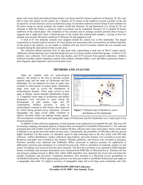
maps to display various <strong>the</strong>matic distributi<strong>on</strong>s (Figure<br />
7). Completed vector maps <str<strong>on</strong>g>of</str<strong>on</strong>g> architecture and artifact<br />
frequencies were c<strong>on</strong>verted to raster format for<br />
development <str<strong>on</strong>g>of</str<strong>on</strong>g> grid surface maps and 3D<br />
visualizati<strong>on</strong>s. Relative elevati<strong>on</strong> is used in<br />
<str<strong>on</strong>g>archaeological</str<strong>on</strong>g> research to find features that might not<br />
be visible during ground <str<strong>on</strong>g>survey</str<strong>on</strong>g> operati<strong>on</strong>s. Accurate<br />
topographic site maps reveal subtle variati<strong>on</strong>s in<br />
relative elevati<strong>on</strong> which can indicate human agency.<br />
METHODS AND ANALYSIS<br />
ASPRS/MAPPS 2009 Fall C<strong>on</strong>ference<br />
November 16-19, 2009 * San Ant<strong>on</strong>ia, Texas<br />
Figure 7. Thematic map <str<strong>on</strong>g>of</str<strong>on</strong>g> obsidian by source<br />
distributi<strong>on</strong>s at Dos Quebradas.<br />
The development <str<strong>on</strong>g>of</str<strong>on</strong>g> planimetric and topographic maps <str<strong>on</strong>g>of</str<strong>on</strong>g> Chichicaste and Dos Quebradas was a major goal <str<strong>on</strong>g>of</str<strong>on</strong>g> our<br />
research program.<br />
In additi<strong>on</strong> to data collecti<strong>on</strong> equipment, several programs were employed to accomplish this task. The core GIS<br />
for housing, mapping, and spatial analysis <str<strong>on</strong>g>of</str<strong>on</strong>g> project data was designed in GeoMedia Pr<str<strong>on</strong>g>of</str<strong>on</strong>g>essi<strong>on</strong>al 6.1. We collected<br />
positi<strong>on</strong>al data with Trimble GeoXT and Geo Explorer III data collectors and a laser total stati<strong>on</strong>. Dense scrub made<br />
it difficult to set up <strong>the</strong> laser total stati<strong>on</strong> in most areas. C<strong>on</strong>sequently, <strong>the</strong> portability <str<strong>on</strong>g>of</str<strong>on</strong>g> GPS data collectors proved<br />
highly beneficial. For that reas<strong>on</strong>, we ultimately opted to map remaining areas at <strong>the</strong> sites solely with GPS data<br />
collectors. Artifact distributi<strong>on</strong>s, surface collecti<strong>on</strong>s (dog-leashes), and some features were recorded as point data.<br />
Roadways and paths were recorded as line features. Mounds, platforms, and terraces were recorded as polyg<strong>on</strong>s.<br />
Positi<strong>on</strong>s recorded were imported into Pathfinder Office, processed to improve accuracy by applicati<strong>on</strong> <str<strong>on</strong>g>of</str<strong>on</strong>g><br />
differential correcti<strong>on</strong> and calculati<strong>on</strong> <str<strong>on</strong>g>of</str<strong>on</strong>g> a centroid for each array. Prior to calculati<strong>on</strong> <str<strong>on</strong>g>of</str<strong>on</strong>g> centroids, outliers in each<br />
cluster <str<strong>on</strong>g>of</str<strong>on</strong>g> readings were removed from <strong>the</strong> array manually. The derivative positi<strong>on</strong>s were exported to ESRI shapefile<br />
format. Coordinate and elevati<strong>on</strong> informati<strong>on</strong> were extracted from ESRI files in Micros<str<strong>on</strong>g>of</str<strong>on</strong>g>t Excel. Positi<strong>on</strong>s for line<br />
and polyg<strong>on</strong> readings housed in dBase files within ESRI shapefiles were imported into Excel and c<strong>on</strong>verted into<br />
useable coordinates and elevati<strong>on</strong>s. Completed datasheets were attached to a Micros<str<strong>on</strong>g>of</str<strong>on</strong>g>t Access geodatabase in<br />
GeoMedia Pr<str<strong>on</strong>g>of</str<strong>on</strong>g>essi<strong>on</strong>al. Points representing positi<strong>on</strong>s were <strong>the</strong>n geo-coded in GeoMedia Pr<str<strong>on</strong>g>of</str<strong>on</strong>g>essi<strong>on</strong>al and output to<br />
a topographic data table. To improve accuracy <str<strong>on</strong>g>of</str<strong>on</strong>g> topographic maps and avoid large areas c<strong>on</strong>taining void cells,


