

Boundary-layer height detection with a ceilometer at a coastal ... - Orbit
Boundary-layer height detection with a ceilometer at a coastal ... - Orbit
Boundary-layer height detection with a ceilometer at a coastal ... - Orbit

Create successful ePaper yourself
Turn your PDF publications into a flip-book with our unique Google optimized e-Paper software.
DTU Wind Energy Master Thesis M-0039<br />
<strong>Boundary</strong>-<strong>layer</strong> <strong>height</strong> <strong>detection</strong> <strong>with</strong><br />
a <strong>ceilometer</strong> <strong>at</strong> a <strong>coastal</strong> site in<br />
western Denmark<br />
Ásta Hannesdóttir<br />
DTU Wind Energy, Risø Campus,<br />
Technical University of Denmark, Roskilde, Denmark<br />
June 2013
Author: Ásta Hannesdóttir<br />
Title: <strong>Boundary</strong>-<strong>layer</strong> <strong>height</strong> <strong>detection</strong> <strong>with</strong> a <strong>ceilometer</strong> <strong>at</strong> a <strong>coastal</strong><br />
site in western Denmark<br />
Department: Niels Bohr Institute and DTU Wind Energy<br />
Supervisors: Alfredo Peña, DTU Wind Energy, Risø<br />
Sven-Erik Gryning, DTU Wind Energy, Risø<br />
Aksel Walløe Hansen, University of Copenhagen<br />
DTU Wind Energy<br />
Master Thesis M-<br />
0039<br />
June 14, 2013<br />
Abstract<br />
One year of d<strong>at</strong>a from <strong>ceilometer</strong> measurements is used to estim<strong>at</strong>e<br />
the <strong>at</strong>mospheric boundary-<strong>layer</strong> <strong>height</strong> <strong>at</strong> the <strong>coastal</strong> site<br />
Høvsøre in western Denmark. The <strong>at</strong>mospheric boundary-<strong>layer</strong> <strong>height</strong><br />
is a fundamental parameter for the evalu<strong>at</strong>ion of the wind speed<br />
profile, and an essential parameter in <strong>at</strong>mospheric transport- and dispersion<br />
models. A new method of filtering clouds from the <strong>ceilometer</strong><br />
d<strong>at</strong>a is presented. This allows for the inclusion of more than half<br />
of the d<strong>at</strong>a in the subsequent analysis, as the presence of clouds<br />
would otherwise complic<strong>at</strong>e the boundary-<strong>layer</strong> <strong>height</strong> estim<strong>at</strong>ions.<br />
The boundary-<strong>layer</strong> <strong>height</strong> is estim<strong>at</strong>ed <strong>with</strong> four different <strong>detection</strong><br />
methods implemented in an autom<strong>at</strong>ed <strong>detection</strong> algorithm. Two of<br />
the <strong>detection</strong> methods used have been modified and are shown to<br />
improve the <strong>detection</strong>s under certain circumstances.<br />
Comparisons of boundary-<strong>layer</strong> <strong>height</strong> estim<strong>at</strong>es from <strong>ceilometer</strong> d<strong>at</strong>a<br />
are made <strong>with</strong> those from turbulence measurements of a wind lidar and<br />
the two methods are in good agreement. It is found th<strong>at</strong> detecting the<br />
boundary-<strong>layer</strong> <strong>height</strong> from turbulence kinetic energy consider<strong>at</strong>ions<br />
<strong>with</strong> the wind lidar is not recommendable for detecting the boundary<strong>layer</strong><br />
<strong>height</strong> during the presence of clouds.<br />
The boundary-<strong>layer</strong> <strong>height</strong> estim<strong>at</strong>es are then used to analyse the daily<br />
evolution of the boundary <strong>layer</strong> and to perform monthly and annual frequency<br />
distributions of the boundary-<strong>layer</strong> <strong>height</strong>. For westerly winds<br />
bi-modal distributions are often found, which may be separ<strong>at</strong>ed by<br />
different criteria, while for easterly winds it is seldom possible. The<br />
<strong>ceilometer</strong> d<strong>at</strong>a shows potential to be used to perform extensive studies<br />
of the boundary <strong>layer</strong>.<br />
Pages: 76<br />
Tables: 14<br />
Figures: 56<br />
References: 47<br />
Technical University<br />
of Denmark<br />
Frederiksborgvej 399<br />
4000 Roskilde<br />
Denmark<br />
Tel. +4546775024<br />
bcar@dtu.dk<br />
www.vindenergi.dk
Contents<br />
1 Introduction 5<br />
1.1 Thesis contents . . . . . . . . . . . . . . . . . . . . . . . . . . . . . . . . . 6<br />
2 Theory 7<br />
2.1 Introduction to the <strong>at</strong>mospheric boundary <strong>layer</strong> . . . . . . . . . . . . . . . . 7<br />
2.2 Entrainment . . . . . . . . . . . . . . . . . . . . . . . . . . . . . . . . . . . 8<br />
2.3 Flow and scales . . . . . . . . . . . . . . . . . . . . . . . . . . . . . . . . . 9<br />
2.4 Turbulence kinetic energy . . . . . . . . . . . . . . . . . . . . . . . . . . . . 9<br />
2.5 The Obukhov Length . . . . . . . . . . . . . . . . . . . . . . . . . . . . . . 10<br />
2.6 The marine boundary <strong>layer</strong> . . . . . . . . . . . . . . . . . . . . . . . . . . . 11<br />
2.7 <strong>Boundary</strong>-<strong>layer</strong> clouds . . . . . . . . . . . . . . . . . . . . . . . . . . . . . . 12<br />
2.8 St<strong>at</strong>istical methods . . . . . . . . . . . . . . . . . . . . . . . . . . . . . . . 13<br />
3 Site and measurements 16<br />
3.1 Høvsøre . . . . . . . . . . . . . . . . . . . . . . . . . . . . . . . . . . . . . 16<br />
3.2 The <strong>ceilometer</strong> . . . . . . . . . . . . . . . . . . . . . . . . . . . . . . . . . . 16<br />
3.3 The wind LIDAR . . . . . . . . . . . . . . . . . . . . . . . . . . . . . . . . 17<br />
3.4 Sonic anemometer . . . . . . . . . . . . . . . . . . . . . . . . . . . . . . . . 19<br />
3.5 Instrumental set-up . . . . . . . . . . . . . . . . . . . . . . . . . . . . . . . 20<br />
3.6 The Høvsøre d<strong>at</strong>abase . . . . . . . . . . . . . . . . . . . . . . . . . . . . . . 21<br />
4 <strong>Boundary</strong>-<strong>layer</strong> <strong>height</strong> <strong>detection</strong> 22<br />
4.1 The vertical gradient of the aerosol profile . . . . . . . . . . . . . . . . . . . 22<br />
4.2 Critical threshold value of the aerosol profile . . . . . . . . . . . . . . . . . . 23<br />
4.3 Fitting an idealized aerosol backsc<strong>at</strong>ter profile . . . . . . . . . . . . . . . . . 24<br />
4.4 Addition to the idealized profile . . . . . . . . . . . . . . . . . . . . . . . . . 25<br />
4.5 Filtering clouds . . . . . . . . . . . . . . . . . . . . . . . . . . . . . . . . . 25<br />
4.6 Minimum turbulence kinetic energy . . . . . . . . . . . . . . . . . . . . . . . 27<br />
5 Results 29<br />
5.1 Clouds . . . . . . . . . . . . . . . . . . . . . . . . . . . . . . . . . . . . . . 29<br />
5.2 Continuous and average d<strong>at</strong>a . . . . . . . . . . . . . . . . . . . . . . . . . . 34<br />
5.3 Comparison <strong>with</strong> a wind lidar . . . . . . . . . . . . . . . . . . . . . . . . . . 39<br />
5.4 Cold front passage . . . . . . . . . . . . . . . . . . . . . . . . . . . . . . . . 44<br />
5.5 Ideal daily evolution of the ABL . . . . . . . . . . . . . . . . . . . . . . . . 47<br />
5.6 Exponent idealized profile . . . . . . . . . . . . . . . . . . . . . . . . . . . . 49<br />
5.7 Evolution of the CTBL . . . . . . . . . . . . . . . . . . . . . . . . . . . . . 51<br />
5.8 Frequency distributions of BLH estim<strong>at</strong>es . . . . . . . . . . . . . . . . . . . 55<br />
5.9 Intra-annual vari<strong>at</strong>ion . . . . . . . . . . . . . . . . . . . . . . . . . . . . . . 66<br />
6 Discussion 67<br />
7 Conclusion 71<br />
A Appendix 72<br />
B Appendix 73<br />
References 74<br />
4 DTU Wind Energy Master Thesis M-0039
1 Introduction<br />
The study of our Earth and its <strong>at</strong>mosphere has led to an understanding th<strong>at</strong> the <strong>at</strong>mosphere<br />
is far from homogeneous, but instead complex and dynamical. The <strong>at</strong>mospheric boundary<br />
<strong>layer</strong> (ABL) may be defined as the lowest part of the troposphere, where the <strong>at</strong>mospheric<br />
flow is directly influenced by the surface, and responds to changes in the surface forcings<br />
<strong>with</strong>in an hour or less Stull (1988). It is an important factor in understanding the lowest<br />
part of the <strong>at</strong>mosphere, and in many different branches of <strong>at</strong>mospheric research it is used<br />
for modelling and experimental consider<strong>at</strong>ions. Similarly the <strong>height</strong> of the ABL, called the<br />
boundary-<strong>layer</strong> <strong>height</strong> (BLH) separ<strong>at</strong>es the turbulent ABL from the free <strong>at</strong>mosphere (FA)<br />
above, and is an essential parameter in defining the ABL. As transport of many quantities<br />
such as pollutants, energy, w<strong>at</strong>er vapor and aerosols is governed by the dynamics of wind,<br />
the BLH plays an important role in both theoretical and numerical meteorological studies, e.g.<br />
- When working <strong>with</strong> wind energy and the placement of wind turbines, wind profile models<br />
are applied, where the BLH is an important parameter of the vertical wind speed profile<br />
(Peña et al., 2010).<br />
- Pollution dispersion models. The BLH is a necessary parameter in models simul<strong>at</strong>ing<br />
turbulent diffusion and transport of pollutants in the <strong>at</strong>mosphere (Seibert et al., 1998).<br />
- Improvement of mesoscale numerical we<strong>at</strong>her prediction models to predict the BLH <strong>at</strong> a<br />
regional scale (Gryning and B<strong>at</strong>chvarova, 2002).<br />
Despite the importance of the BLH, it does not have an exact definition, or straightforward<br />
method of measurement. It is a parameter hard to define, and cannot always be inferred from<br />
a simple equ<strong>at</strong>ion, especially not in convective conditions (B<strong>at</strong>chvarova and Gryning, 1991).<br />
Synoptic we<strong>at</strong>her, vertical wind shear and stability conditions <strong>at</strong> the surface all influence the<br />
value of the BLH, which may vary significantly in time and space.<br />
Also, as the BLH is often found in the range of hundreds of meters to kilometers, conventional<br />
instruments such as radio sondes and masts often lack either the temporal or sp<strong>at</strong>ial<br />
resolution to provide sufficient d<strong>at</strong>a for determining the BLH s<strong>at</strong>isfactorily.<br />
Remote sensors such as lidar are therefore a valuable tool in measuring the BLH. Even so,<br />
a remote sensor cannot measure all meteorological conditions. Therefore, when studying the<br />
<strong>at</strong>mospheric BLH, it may be advantageous to include different methods and approaches for<br />
a complete picture of the key <strong>at</strong>mospheric processes.<br />
The method for BLH <strong>detection</strong> in this thesis is primarily by use of a <strong>ceilometer</strong>, which<br />
will be presented in detail in section 3. A major advantage of using remote sensors such as<br />
a <strong>ceilometer</strong>, is th<strong>at</strong> it measures continuously and over a large vertical range. In contrast to<br />
radio sondes which are limited by the r<strong>at</strong>e of release and masts being limited by their <strong>height</strong>.<br />
In this study a new BLH <strong>detection</strong> method is described and a new efficient way of handling<br />
complic<strong>at</strong>ions arising in the presence of clouds is presented and tested. For the first time a<br />
detailed analysis of frequency distributions of BLH estim<strong>at</strong>es is performed on d<strong>at</strong>a from an<br />
entire year of measurements <strong>at</strong> the measuring site Høvsøre. Further, the BLH and its rel<strong>at</strong>ion<br />
to specific conditions of wind, temper<strong>at</strong>ure and season is investig<strong>at</strong>ed.<br />
5
1.1 Thesis contents<br />
The content of this thesis is as follows. In Section 2 the relevant theoretical background of<br />
boundary-<strong>layer</strong> studies is presented. Section 3 describes the measuring site and the instrument<strong>at</strong>ion<br />
used for the observ<strong>at</strong>ions in this thesis. Different methods of BLH <strong>detection</strong> are<br />
presented in Section 4. In this section is also introduced two new approaches in d<strong>at</strong>a processing.<br />
The first is an addition to one of the existing methods of BLH <strong>detection</strong>. The second is<br />
a simple method of filtering clouds from the <strong>ceilometer</strong> d<strong>at</strong>a. In Section 5 the results of the<br />
investig<strong>at</strong>ions are presented, and a discussion of these is given in Section 6. A brief summary<br />
of the main conclusions is given in Section 7 along <strong>with</strong> possible outlooks.<br />
6 DTU Wind Energy Master Thesis M-0039
2 Theory<br />
2.1 Introduction to the <strong>at</strong>mospheric boundary <strong>layer</strong><br />
One of the most important fe<strong>at</strong>ures of the ABL is the continuous turbulence in the whole<br />
region, which is mostly produced by vertical wind shear and buoyancy. Turbulence mixes<br />
quantities like humidity, temper<strong>at</strong>ure and aerosols in the ABL, transmitting them from the<br />
surface through the ABL to the rest of the <strong>at</strong>mosphere.<br />
Figure 1: Vertical cross section of the ideal ABL structure over land during summer in cloud<br />
free conditions. NBL is the nocturnal boundary <strong>layer</strong>. Figure from Garr<strong>at</strong>t (1992).<br />
The daily evolution of the ABL over land on a clear day in a high pressure region may be<br />
seen in Figure 1. The structure of the ABL turbulence is strongly influenced by the surface<br />
he<strong>at</strong>ing and cooling. The surface <strong>layer</strong> is seen in the figure as the lowest part of the ABL,<br />
its <strong>height</strong> is approxim<strong>at</strong>ely 10% of the ABL <strong>height</strong>. In the surface <strong>layer</strong> the mean fluxes of<br />
momentum, he<strong>at</strong> and moisture are near constant. The vertical wind gradient is large and the<br />
wind speed in the surface <strong>layer</strong> may be expressed <strong>with</strong> a logarithmic wind profile under neutral<br />
<strong>at</strong>mospheric conditions 1 (Larsen, 2009; Stull, 1988).<br />
In the morning shortly after sunrise, the convective ABL starts to form (indic<strong>at</strong>ed by marker<br />
A in Figure 1). The sun he<strong>at</strong>s the surface leading to thermal instability and convection in<br />
the surface <strong>layer</strong>. Above the convective surface <strong>layer</strong> the mixed <strong>layer</strong> (ML) is formed. The<br />
ML is domin<strong>at</strong>ed by convective motion and buoyant turbulence gener<strong>at</strong>ion including large<br />
turbulent eddies. Mean vertical profiles of potential temper<strong>at</strong>ure, humidity and horizontal<br />
wind are nearly constant <strong>with</strong>in the ML as seen in Figure 2(a). Potential temper<strong>at</strong>ure is<br />
defined as the temper<strong>at</strong>ure an air parcel would have if it were brought adiab<strong>at</strong>ically to a<br />
reference pressure (usually 1000 mb). Aerosols th<strong>at</strong> often origin<strong>at</strong>e from the surface get<br />
mixed through the convective ABL as well. At the top of the ML is a strong capping inversion<br />
called the interfacial <strong>layer</strong> (Wyngaard, 2010; Garr<strong>at</strong>t, 1992) or the entrainment zone (Gryning<br />
1 i.e. when the he<strong>at</strong> flux is negligible<br />
7
and B<strong>at</strong>chvarova, 1994; Stull, 1988). This capping inversion prevents turbulent motion from<br />
bene<strong>at</strong>h the interfacial <strong>layer</strong> to penetr<strong>at</strong>e far into the free <strong>at</strong>mosphere.<br />
(a)<br />
(b)<br />
Figure 2: Typical vertical profiles of temper<strong>at</strong>ure (T ), potential temper<strong>at</strong>ure (θ), specific<br />
humidity (q) and wind speed (V ) during daytime (a) and nighttime (b). Abbrevi<strong>at</strong>ions: free<br />
<strong>at</strong>mosphere (FA), entrainment zone (EZ), mixed <strong>layer</strong> (ML), surface <strong>layer</strong> (SL), capping<br />
inversion (CI), residual <strong>layer</strong> (RL), stable boundary <strong>layer</strong> (SBL), geostrophic wind speed V g .<br />
Figure from Stull (2006).<br />
In the evening right before sunset, the stable boundary <strong>layer</strong> (SBL) 2 starts to form (indic<strong>at</strong>ed<br />
by marker B in Figure 1), when the surface cools down as a result of radi<strong>at</strong>ive cooling.<br />
The SBL may also form when warm air is advected over a cooler surface. Turbulence is<br />
much weaker than compared <strong>with</strong> turbulence in the convective ABL and turbulent eddies are<br />
smaller. Turbulence is mechanically gener<strong>at</strong>ed by wind shear and may result in a well mixed<br />
stable <strong>layer</strong>. However stability tends to dampen turbulence gener<strong>at</strong>ion, and the strength of<br />
the turbulence depends on the specific conditions. Above the SBL is the residual <strong>layer</strong>, where<br />
turbulence is decaying and residual he<strong>at</strong>, moisture and aerosols th<strong>at</strong> were mixed during the<br />
afternoon are still present. In Figure 2(b) a sharp increase in the potential temper<strong>at</strong>ure is seen<br />
directly above the surface, reaching constant values towards the top of the SBL. This indic<strong>at</strong>es<br />
th<strong>at</strong> stability is highest near the surface, gradually decreasing towards neutral conditions <strong>at</strong><br />
the top of the SBL. Winds may increase <strong>with</strong> <strong>height</strong> in the SBL, becoming supergeostrophic<br />
<strong>at</strong> the top of the SBL. This is often referred to as a nocturnal jet.<br />
2.2 Entrainment<br />
Turbulent entrainment is a process th<strong>at</strong> mixes warm (in a potential temper<strong>at</strong>ure sense) and<br />
dry air from the FA into the ML. Warm thermals from the surface rise through the ML during<br />
free convection and gain momentum. As the thermals reach the free <strong>at</strong>mosphere they<br />
penetr<strong>at</strong>e a short distance due to their momentum. Then they become neg<strong>at</strong>ively buoyant in<br />
the warm air and sink back to the ML. While these thermals overshoot in the inversion <strong>layer</strong>,<br />
warm quasi-nonturbulent air from the free <strong>at</strong>mosphere is pushed down in to the ML. This air<br />
mixes <strong>with</strong> the turbulent ML air and the result is mixed-<strong>layer</strong> growth and entrainment of less<br />
turbulent free <strong>at</strong>mospheric air into the ML (Stull, 1988).<br />
The instantaneous top of the ML is quite sharp and has a varying <strong>height</strong> in space. Averaging<br />
in time, space or an ensemble produces a much thicker interfacial <strong>layer</strong> as seen in Figure 2(a).<br />
The interfacial <strong>layer</strong> is often defined <strong>with</strong> horizontal or temporal averaging and the depth of<br />
the <strong>layer</strong> is often 10–30% of the whole CBL depth, but may be much thicker especially in<br />
the morning. Wh<strong>at</strong> characterizes the interfacial <strong>layer</strong> is a strong positive temper<strong>at</strong>ure lapse<br />
r<strong>at</strong>e, often significant vertical wind shear, and sharp decreases in aerosol content and specific<br />
humidity (Seibert et al., 1998).<br />
2 often called the nocturnal boundary <strong>layer</strong><br />
8 DTU Wind Energy Master Thesis M-0039
2.3 Flow and scales<br />
There is a rough scale of proportionality between time and sp<strong>at</strong>ial scales for <strong>at</strong>mospheric<br />
flow processes, i.e. large scale <strong>at</strong>mospheric motions are associ<strong>at</strong>ed <strong>with</strong> large time scales and<br />
small scale motions, like turbulence, are associ<strong>at</strong>ed <strong>with</strong> small time scales (Larsen, 2009).<br />
Large we<strong>at</strong>her systems <strong>with</strong> sp<strong>at</strong>ial scales of about 1000 km may last for weeks. Microscale<br />
or boundary-<strong>layer</strong> meteorology is the study of <strong>at</strong>mospheric phenomena <strong>with</strong> time scales less<br />
than an hour and sp<strong>at</strong>ial scales smaller than 3 km (Stull, 1988).<br />
Turbulence in the ABL may be imagined as swirling motions of localized vorticity, called<br />
eddies. The largest eddies, produced by convective motion, may have a sp<strong>at</strong>ial scale as the<br />
depth of the ABL. Aside from thermals of rising (or sinking) air, wind shear continuously<br />
produces eddies. These large eddies, superimposed on the mean flow, interact <strong>with</strong> the mean<br />
shear and other eddies producing new smaller eddies, th<strong>at</strong> then cascade to even smaller eddies,<br />
and so on. The smallest eddies are only a few millimetres in size and will eventually<br />
transform into he<strong>at</strong> by the molecular friction in the air (Larsen, 2009). This mechanism is<br />
commonly referred to as the energy cascade.<br />
The turbulent wind flow in the ABL is often described by a mean flow and perturb<strong>at</strong>ion<br />
flow. Turbulence causes wind measurements to show a fluctu<strong>at</strong>ing part, regardless of the<br />
time resolution of the measurements. To separ<strong>at</strong>e the wind in a mean and a turbulent part a<br />
time average has to be performed. This time averaging may span an interval on the order of<br />
minutes to an hour, the exact value depending on the specific quantity to be recorded. The<br />
turbulent part of the horizontal wind may be found by subtracting the mean wind from the<br />
instantaneous wind<br />
u ′ = U − U (1)<br />
where u ′ is the turbulent wind component, U is the instantaneous wind component and U<br />
is the mean wind component. The mean and turbulent parts of all other <strong>at</strong>mospheric variables<br />
may be found in the same manner.<br />
By definition, the turbulent part of the wind field will always average to zero. A common<br />
measure of the turbulent part and the dispersion of d<strong>at</strong>a about the mean is the unbiased<br />
variance,<br />
σ 2 u = 1<br />
N − 1<br />
N∑<br />
(U i − Ū)2 = u ′2 . (2)<br />
i=1<br />
Here σ 2 u is the unbiased variance of the wind velocity. The summ<strong>at</strong>ion is over all N wind<br />
velocity measurements u i in the time averaging interval.<br />
2.4 Turbulence kinetic energy<br />
If the three cartesian wind components, U, V and W are known, it is possible to calcul<strong>at</strong>e<br />
the total kinetic energy per unit mass of the flow field, 1 2 (U 2 + V 2 + W 2 ). When a time<br />
average is made the kinetic energy can be separ<strong>at</strong>ed into a mean and a turbulent part, where<br />
the turbulent part is:<br />
ē = 1 2 (u′2 + v ′2 + w ′2 ). (3)<br />
Here u ′ , v ′ and w ′ represent the perturb<strong>at</strong>ion wind components, and ē is the mean turbulence<br />
kinetic energy (TKE). The physical processes th<strong>at</strong> produce and dissip<strong>at</strong>e turbulence in<br />
the ABL may be investig<strong>at</strong>ed by looking <strong>at</strong> the TKE budget equ<strong>at</strong>ion. When assuming horizontal<br />
homogeneity, aligning the coordin<strong>at</strong>e system parallel <strong>with</strong> the mean horizontal wind<br />
and neglecting subsidence a simplified version of the TKE budget equ<strong>at</strong>ion has the form:<br />
DTU Wind Energy Master Thesis M-0039 9
∂ē<br />
∂t<br />
= g w ′ θ v ′ − u ′ w ′ ∂U<br />
θ v ∂z − ∂ ∂z w′ e − 1¯ρ<br />
∂<br />
∂z w′ p ′ − ε (4)<br />
where θ v is the virtual potential temper<strong>at</strong>ure, g is the gravit<strong>at</strong>ional constant and p ′ is the<br />
pressure perturb<strong>at</strong>ion. The virtual potential temper<strong>at</strong>ure, θ v , is the temper<strong>at</strong>ure an moist<br />
parcel of air would have, if it was dry and still have the same density. As moist air is less<br />
dense than dry air, and therefore more buoyant, the θ v of moist air is higher than the potential<br />
temper<strong>at</strong>ure of the same parcel (the dry air parcel would have to be warmer to have the same<br />
density). An explan<strong>at</strong>ion for each term in the TKE budget is given as follows:<br />
∂ē<br />
∂t<br />
g<br />
This first term describes the local change in TKE <strong>with</strong> time.<br />
w ′ θ ′ θ v<br />
v The buoyancy production or consumption term, depending on the sign of the he<strong>at</strong><br />
flux. A positive contribution of this term represents the efficiency of thermals in turbulence<br />
gener<strong>at</strong>ion. This term gives a large contribution to the TKE budget on a sunny<br />
day over land, or when cold air is advected over a warm surface. In a positively buoyant<br />
cloud there is also a large gener<strong>at</strong>ion of turbulence. In situ<strong>at</strong>ions <strong>with</strong> st<strong>at</strong>ic stability,<br />
there will be consumption of TKE, and convective motion is suppressed. This is typically<br />
observed <strong>at</strong> night over land or <strong>at</strong> the top of the ML (Stull, 1988).<br />
u ′ w ′ ∂U<br />
∂z<br />
The third term represents interaction between mean wind vertical shear and turbulent<br />
momentum flux. This term is most often positive in the ABL as momentum flux tends<br />
to have opposite sign of the mean wind shear. The largest contribution to the TKE<br />
budget from this term is in the surface <strong>layer</strong> when winds are strong, as the horizontal<br />
wind decreases to zero <strong>at</strong> the surface, resulting in a high mean vertical wind shear.<br />
∂<br />
∂z w′ e This fourth term is the vertical turbulent flux divergence. This is not a consumption<br />
or production term, but represents vertical transport by turbulent eddies.<br />
1 ∂<br />
¯ρ ∂z w′ p ′<br />
The fifth term is a pressure correl<strong>at</strong>ion term and describes how pressure perturb<strong>at</strong>ions,<br />
most often caused by gravity or buoyancy waves, shift TKE. This term is generally<br />
difficult to measure because of the small size of the pressure perturb<strong>at</strong>ions.<br />
ε The last term is the viscous dissip<strong>at</strong>ion r<strong>at</strong>e of TKE. Contributions from this term arise as<br />
the smallest eddies transform their energy to he<strong>at</strong> <strong>at</strong> a molecular level.<br />
The above mentioned TKE budget equ<strong>at</strong>ion is somewh<strong>at</strong> simplified, for example horizontal<br />
advection of TKE by the mean wind and all horizontal divergences of the other terms are<br />
neglected. However this equ<strong>at</strong>ion still gives a good summ<strong>at</strong>ion of wh<strong>at</strong> processes gener<strong>at</strong>e<br />
and consume TKE in the ABL, and how TKE changes <strong>with</strong> time. The deriv<strong>at</strong>ion of the TKE<br />
budget 3 may be found in Stull (1988).<br />
2.5 The Obukhov Length<br />
The Obukhov length is stability parameter th<strong>at</strong> is used as a scaling parameter in the surface<br />
<strong>layer</strong> (Obukhov, 1946).<br />
The Obukhov length may be derived from the TKE budget equ<strong>at</strong>ion assuming horizontal<br />
homogeneity and using Monin-Obukhov similarity hypothesis (Wyngaard, 2010). In the surface<br />
<strong>layer</strong> mean fluxes are assumed near constant, so the vertical turbulent flux divergence<br />
and pressure correl<strong>at</strong>ion terms may be neglected. Furthermore, assuming steady st<strong>at</strong>e, i.e<br />
∂ē/∂t = 0 and th<strong>at</strong> viscous dissip<strong>at</strong>ion of TKE may be neglected, leads to a TKE budget as<br />
follows<br />
3 The TKE budget equ<strong>at</strong>ion may be derived by applying the conserv<strong>at</strong>ion of momentum <strong>with</strong> a Boussinesq<br />
approxim<strong>at</strong>ion for the turbulent flow. This is then multiplied by 2u ′ i , and terms are rewritten <strong>with</strong> rules of<br />
calculus. Applying Reynolds averaging and neglecting small terms leads to the prognostic equ<strong>at</strong>ion for wind<br />
velocity variance, which finally is divided by two.<br />
10 DTU Wind Energy Master Thesis M-0039
g<br />
θ v<br />
w ′ θ ′ v<br />
= u ′ w ′ ∂U<br />
∂z . (5)<br />
If the coordin<strong>at</strong>e system is aligned <strong>with</strong> the mean horizontal wind, u ′ w ′ may be replaced<br />
by the friction velocity −u 2 ∗. The von Kármán constant, k, is defined to scale the friction<br />
velocity in a fully turbulent region near a surface:<br />
k =<br />
u ∗<br />
z∂U/∂z . (6)<br />
The vertical wind shear ∂U/∂z in equ<strong>at</strong>ion 5 may be replaced <strong>with</strong> u ∗ /kz and z expressed<br />
as L, the Obukhov length:<br />
L = − u3 ∗θ v<br />
kgw ′ θ ′ v<br />
where the von Kármán constant has been found experimentally to be approxim<strong>at</strong>ely k = 0.4.<br />
The Obukhov length may be understood physically as being the <strong>height</strong> above the ground where<br />
the buoyancy produced turbulence and mechanically produced turbulence are equal. It can<br />
be seen in equ<strong>at</strong>ion (7) th<strong>at</strong> the sign of L depends of the sign of w ′ θ ′ v which again depends<br />
on the stability conditions. In unstable conditions the temper<strong>at</strong>ure near the surface decreases<br />
<strong>with</strong> <strong>height</strong> and he<strong>at</strong> will be transported upwards by turbulence and w ′ θ ′ v will therefore be<br />
positive. Therefore L is a measure for stability in the surface <strong>layer</strong>. It is common to calcul<strong>at</strong>e<br />
the inverse Obukhov length 1/L. For stable conditions 1/L is positive, whereas 1/L is neg<strong>at</strong>ive<br />
for unstable conditions and 1/L approaches zero for neutral conditions.<br />
2.6 The marine boundary <strong>layer</strong><br />
As mentioned in Section 1 the measuring site of Høvsøre is placed in a <strong>coastal</strong> region, less<br />
than two kilometers inland from the North Sea. As the wind direction is often westerly, the<br />
marine ABL is advected over the coastline <strong>at</strong> Høvsøre.<br />
There are some important differences between marine ABL and th<strong>at</strong> over land. The air <strong>with</strong>in<br />
the surface <strong>layer</strong> over the sea is generally more humid, compared <strong>with</strong> th<strong>at</strong> over land (except<br />
<strong>at</strong> nighttime close to the surface), <strong>with</strong> rel<strong>at</strong>ive humidity (RH) often exceeding 75%. Because<br />
of these high humidities, cloud form<strong>at</strong>ion is frequent and extensive over oceanic regions (Stull,<br />
2006).<br />
The diurnal vari<strong>at</strong>ion in sea-surface temper<strong>at</strong>ure is much less than th<strong>at</strong> of the ground, because<br />
of the large he<strong>at</strong> capacity of the oceanic mixed <strong>layer</strong>. A comparison of the he<strong>at</strong> capacity of a<br />
typical <strong>at</strong>mospheric mixed <strong>layer</strong> (1000 m depth) and an oceanic mixed <strong>layer</strong> (100 m depth)<br />
gives the r<strong>at</strong>io ∼1/350 (Garr<strong>at</strong>t, 1992). The rel<strong>at</strong>ively slow temper<strong>at</strong>ure change of the sea<br />
surface leads to a boundary <strong>layer</strong> <strong>with</strong> different stability conditions and diurnal cycle than over<br />
land. The marine BLH changes rel<strong>at</strong>ively slowly, and changes mainly because of advection of<br />
different air masses over the sea surface and synoptic and mesoscale vertical processes (Stull,<br />
1988). As the marine air mass is advected over the coastline, the change in surface conditions<br />
affects the land air mass. This affected air mass is known as the internal boundary <strong>layer</strong>, <strong>with</strong><br />
a <strong>height</strong> th<strong>at</strong> is dependent on the downwind distance from the coast. This distance is called<br />
fetch, and in the case of Høvsøre is ∼ 1.7 km. When there is a temper<strong>at</strong>ure difference between<br />
the sea surface and land surface, the modified air is called a thermal internal boundary <strong>layer</strong><br />
(TIBL). The <strong>height</strong> of the TIBL has been shown to be proportional to the square root of the<br />
fetch, i.e.<br />
h b = a √ x (8)<br />
where h b is the <strong>height</strong> of the TIBL, x is the fetch, measured in meters, and a is a constant of<br />
proportionality, found to be in the range 2-5. In the case of Høvsøre, this gives an expected<br />
<strong>height</strong> of the TIBL of ∼ 80-200 m. It can take up to 50 km for the internal boundary <strong>layer</strong><br />
to reach a full depth (Garr<strong>at</strong>t, 1992).<br />
DTU Wind Energy Master Thesis M-0039 11<br />
(7)
2.7 <strong>Boundary</strong>-<strong>layer</strong> clouds<br />
The presence of clouds gre<strong>at</strong>ly influences boundary-<strong>layer</strong> dynamics and the surface we<strong>at</strong>her.<br />
Many cloud types are an essential fe<strong>at</strong>ure of the ABL and cannot be separ<strong>at</strong>ed from boundary<strong>layer</strong><br />
studies. These clouds are mainly the low clouds, limited in their vertical extent. They<br />
may be seen in Figure 3 as cumulus, str<strong>at</strong>ocumulus, str<strong>at</strong>us and fog. Clouds th<strong>at</strong> have large<br />
vertical extent cannot be tre<strong>at</strong>ed as an intrinsic part of the ABL.<br />
Figure 3: Main cloud types. Figure from Klaus (2005).<br />
Clouds are often ignored or omitted in boundary-<strong>layer</strong> studies, because they complic<strong>at</strong>e the<br />
boundary-<strong>layer</strong> dynamics. Clouds change the distribution of the incoming short wave radi<strong>at</strong>ion<br />
and outgoing long wave radi<strong>at</strong>ion and phase changes of w<strong>at</strong>er in a cloud causes he<strong>at</strong> release<br />
or consumption. In the absence of clouds, changes of turbulent structure and mean variables<br />
are mainly controlled by surface fluxes and large scale conditions. In the presence of clouds<br />
surface fluxes may be important, but radi<strong>at</strong>ive fluxes rel<strong>at</strong>ing to the cloud have a large impact<br />
on the turbulence production and evolution in the ABL (Garr<strong>at</strong>t, 1992).<br />
Clouds form <strong>at</strong> the top of the ML. Air parcels th<strong>at</strong> overshoot by thermals into the interfacial<br />
<strong>layer</strong> are adiab<strong>at</strong>ically cooled. As an air parcel cools the w<strong>at</strong>er vapour starts to condens<strong>at</strong>e <strong>at</strong><br />
its lifting condens<strong>at</strong>ion level and l<strong>at</strong>ent he<strong>at</strong> is released. If the parcel has enough momentum<br />
and overshoots high enough the potential temper<strong>at</strong>ure, θ of the parcel gets higher than th<strong>at</strong><br />
of the environment. Then the parcel reaches the level of free convection and is positively<br />
buoyant. The parcel continues to rise until it is again cooler than the environment. In this<br />
way air is drawn up from the ML to the cloud <strong>layer</strong>. The lifetime of a cloud is controlled by its<br />
dynamics and interactions <strong>with</strong> its environment. When studying clouds it is often convenient<br />
to use the equivalent potential temper<strong>at</strong>ure θ e , instead of the virtual potential temper<strong>at</strong>ure<br />
θ v . This is because θ e is a conserved variable <strong>with</strong>in the cloud, while θ v is not. The equivalent<br />
potential temper<strong>at</strong>ure is the temper<strong>at</strong>ure a parcel of air would have if all w<strong>at</strong>er vapour <strong>with</strong>in<br />
it would condense.<br />
Fog can form <strong>at</strong> the bottom of a stable boundary <strong>layer</strong>. At night the air close to the ground<br />
cools due to radi<strong>at</strong>ive cooling. It can cool down below the dew point temper<strong>at</strong>ure and reach<br />
s<strong>at</strong>ur<strong>at</strong>ion. A fog <strong>layer</strong> th<strong>at</strong> does not develop further, where only the air close to the ground<br />
is s<strong>at</strong>ur<strong>at</strong>ed, is called mist and is usually only 1–5 m thick. The mist can develop into fog if<br />
radi<strong>at</strong>ive cooling continues and becomes larger <strong>at</strong> the top of the fog <strong>layer</strong> than <strong>at</strong> the surface.<br />
This deepens the fog <strong>layer</strong> and thermals gener<strong>at</strong>ed by the cooling <strong>at</strong> the top of the fog <strong>layer</strong><br />
sink and mix the fog <strong>layer</strong>. Warm and humid air flowing over a cold surface may also result<br />
in fog form<strong>at</strong>ion.<br />
12 DTU Wind Energy Master Thesis M-0039
The cloud topped boundary <strong>layer</strong><br />
When a cloud <strong>layer</strong> and a ML are fully coupled, the idealized profiles of θ e , θ v and the total<br />
w<strong>at</strong>er mixing r<strong>at</strong>io, q, will look like in Figure 4. The total w<strong>at</strong>er mixing r<strong>at</strong>io and the equivalent<br />
potential temper<strong>at</strong>ure are constant <strong>with</strong> <strong>height</strong>. This indic<strong>at</strong>es th<strong>at</strong> when a cloud <strong>layer</strong> and<br />
the ML are turbulently fully coupled, the cloud is an essential part of the ML. The θ v profile<br />
follows the moist adiab<strong>at</strong>ic in the cloud <strong>layer</strong>.<br />
Figure 4: Idealized profiles of mean variables <strong>with</strong>in a str<strong>at</strong>ocumulus topped ML. (a) Cloud loc<strong>at</strong>ion,<br />
(b) total w<strong>at</strong>er mixing r<strong>at</strong>io, (c) equivalent potential temper<strong>at</strong>ure, (d) virtual potential<br />
temper<strong>at</strong>ure. Adapted from Stull (1988).<br />
The air above the cloud is warmer (in a potential temper<strong>at</strong>ure sense) and drier than the<br />
cloud air. When dry warm air from above entrains the cloud some liquid w<strong>at</strong>er from cloud<br />
droplets evapor<strong>at</strong>es and evapor<strong>at</strong>ive cooling occurs. The air becomes neg<strong>at</strong>ively buoyant and<br />
produces TKE th<strong>at</strong> increases mixing and more entrainment in the cloud. This process usually<br />
causes the ML to become drier and warmer and raises the <strong>height</strong> of the cloud <strong>layer</strong>. If a large<br />
amount of dry air entrains the cloud it may cause it to break up and evapor<strong>at</strong>e (Stull, 1988).<br />
Measurements show th<strong>at</strong> cloud air is a mixture of air origin<strong>at</strong>ing <strong>at</strong> the cloud top and the<br />
cloud base (Betts, 1985).<br />
The cloud top entrainment gener<strong>at</strong>es TKE <strong>with</strong>in the cloud. Turbulent mixing is generally<br />
high <strong>with</strong>in clouds and several other processes contribute to the TKE gener<strong>at</strong>ion: Free convection<br />
from the surface, shear gener<strong>at</strong>ed turbulence, cloud <strong>layer</strong> shear, cloud top radi<strong>at</strong>ive<br />
cooling and cloud base radi<strong>at</strong>ive he<strong>at</strong>ing.<br />
In the case of a cloud topped boundary <strong>layer</strong> (CTBL), different ways of defining the BLH<br />
exist. First, the BLH may correspond to the cloud top. In this case the CTBL is defined as<br />
a <strong>layer</strong> th<strong>at</strong> is directly coupled to the surface by turbulent transfer, including fair-we<strong>at</strong>her<br />
cumulus and str<strong>at</strong>ocumulus clouds. Here a noticeable inversion exists <strong>at</strong> the cloud top, but<br />
the CTBL tends not to be well mixed above the cloud base (Stull, 1988; Garr<strong>at</strong>t, 1992).<br />
Second, the BLH may be defined <strong>at</strong> or near the cloud base. With this definition the BLH<br />
corresponds well to the top of a rel<strong>at</strong>ively well-mixed <strong>layer</strong> and to a <strong>height</strong> where turbulent<br />
fluxes of he<strong>at</strong> and momentum become negligible (Garr<strong>at</strong>t, 1992). A third definition of the<br />
BLH is proposed by Grimsdell and Angevine (1998), which st<strong>at</strong>es th<strong>at</strong> when the cloud cover<br />
is roughly 50% or less and the cloud <strong>layer</strong> is not deep compared <strong>with</strong> the ABL underne<strong>at</strong>h,<br />
the cloud <strong>layer</strong> may be considered to define the interfacial <strong>layer</strong>. The corresponding BLH may<br />
then be defined as approxim<strong>at</strong>ely in the middle of the cloud <strong>layer</strong>.<br />
2.8 St<strong>at</strong>istical methods<br />
A few st<strong>at</strong>istical methods used for the d<strong>at</strong>a analysis are presented here. The unbiased variance<br />
has already been introduced in Section 2.3 in Equ<strong>at</strong>ion 2. The standard devi<strong>at</strong>ion is given by<br />
DTU Wind Energy Master Thesis M-0039 13
the square root of the variance.<br />
Root mean square devi<strong>at</strong>ion<br />
The root mean square devi<strong>at</strong>ion (RMSD) or root mean square error (RMSE) is a measure of<br />
differences between two measurements of the same parameter. It may also compare model<br />
output <strong>with</strong> measurements. The RMSD is defined by:<br />
N∑<br />
√<br />
(x i − y i ) 2<br />
i=1<br />
RMSD =<br />
N<br />
where x i is the model output of index i and y i is the observ<strong>at</strong>ion of index i. The number of<br />
model output and observ<strong>at</strong>ion pairs is given by N. It is clearly seen th<strong>at</strong> if there is a lack of<br />
comp<strong>at</strong>ibility between model outputs and observ<strong>at</strong>ions the RMSD will be large (Wilks, 2011).<br />
(9)<br />
Correl<strong>at</strong>ion<br />
When investig<strong>at</strong>ing the rel<strong>at</strong>ion between two d<strong>at</strong>a series, x and y, it is convenient to calcul<strong>at</strong>e<br />
the correl<strong>at</strong>ion coefficient, R, given as<br />
N∑<br />
(x i − ¯x)(y i − ȳ)<br />
i=1<br />
R = √<br />
(10)<br />
N∑ ∑<br />
(x i − ¯x) 2 N (y i − ȳ) 2<br />
i=1<br />
where ¯x and ȳ are the sample means of x and y. When determining if the correl<strong>at</strong>ion is<br />
significant on a given level, the number of elements in the d<strong>at</strong>a series, N, must be included.<br />
The values of R required for two confidence levels are shown in table 1, for different values<br />
of N, th<strong>at</strong> are relevant for this thesis. This confidence level gives the probability th<strong>at</strong> the<br />
correl<strong>at</strong>ion is not by chance, given th<strong>at</strong> the d<strong>at</strong>asets are independent (Kreyszig, 1999).<br />
i=1<br />
Confidence level N = 125 N = 135 N = 145<br />
99% R = 0.21 R = 0.21 R = 0.20<br />
99.9% R = 0.28 R = 0.27 R = 0.26<br />
Table 1: Confidence levels for different values of N .<br />
Linear regression<br />
Linear regression is a st<strong>at</strong>istical procedure, modelling the rel<strong>at</strong>ionship between two variables<br />
(here x and y), summarized by a single straight line. The most common type of linear regression<br />
is a least-squares fit, where the regression procedure minimizes the squared differences<br />
between a set of measurements and their predicted values. Given a d<strong>at</strong>aset of N individual<br />
(x i ,y i ) pairs, the regression produces the constants a and b in the straight line ŷ = ax + b by<br />
minimizing the sum of (y i −ŷ(x i )) 2 . When solving the straight line fit for the linear regression,<br />
the slope of the straight line, a, is given by<br />
and b is subsequently found by<br />
a =<br />
N∑<br />
(x i − ¯x)(y i − ȳ)<br />
i=1<br />
(11)<br />
N∑<br />
(x i − ¯x) 2<br />
i=1<br />
b = ȳ − a¯x (12)<br />
14 DTU Wind Energy Master Thesis M-0039
where ¯x and ȳ are the sample means of x and y.<br />
Gamma distribution<br />
The Gamma distribution is a continuous probability density function of two free parameters<br />
α and s. The general form of a Gamma distributed random variable, x, is<br />
f(x; α, s) = x α−1 ·<br />
e −x/s<br />
s α · Γ(α)<br />
where α is the shape parameter, s is the scale parameter and Γ is the Gamma function.<br />
The mean of the Gamma distribution is given by αs and the mean is √ αs (Liu and Liang,<br />
2010).<br />
(13)<br />
DTU Wind Energy Master Thesis M-0039 15
3 Site and measurements<br />
In this section the site loc<strong>at</strong>ion is presented and some of the instruments used there. The<br />
theoretical background of the <strong>ceilometer</strong>, wind lidar and sonic anemometer measurements is<br />
explained, along <strong>with</strong> a present<strong>at</strong>ion of the available d<strong>at</strong>a from the site d<strong>at</strong>abase.<br />
3.1 Høvsøre<br />
Høvsøre is a farm area loc<strong>at</strong>ed <strong>at</strong> the westcoast of Jutland, seen in Figure 5(a). Here, a<br />
<strong>ceilometer</strong> has oper<strong>at</strong>ed almost continuously since january 2007. The loc<strong>at</strong>ion of Høvsøre was<br />
chosen in 2002 to be a n<strong>at</strong>ional test facility for large wind turbines, seen in Figure 5(b). Due<br />
to the loc<strong>at</strong>ion and the type of terrain, wind speeds are very high 4 and general wind p<strong>at</strong>terns<br />
are very well understood, providing excellent conditions for the testing (Høvsøre infofolder,<br />
2013).<br />
5 ◦ E 7 ◦ E 9 ◦ E 11 ◦ E 13 ◦ E<br />
NORTH SEA<br />
Høvsøre<br />
DENMARK<br />
56 ◦ N 56 ◦ N<br />
Copenhagen<br />
km<br />
0 50 100<br />
7 ◦ E 9 ◦ E 11 ◦ E 13 ◦ E<br />
(a)<br />
(b)<br />
Figure 5: (a): Map of Jutland, <strong>with</strong> Høvsøre indic<strong>at</strong>ed (map made by Rogier Floors). (b):<br />
View of Høvsøre test st<strong>at</strong>ion, <strong>with</strong> oper<strong>at</strong>ional wind turbines. Picture from Høvsøre infofolder<br />
(2013).<br />
3.2 The <strong>ceilometer</strong><br />
The <strong>ceilometer</strong> is a single lens LIDAR (Light Detection And Ranging) device, which is primarily<br />
used to detect cloud base and vertical visibility. It transmits short pulses of light in the<br />
near-vertical direction. The light is sc<strong>at</strong>tered by particles in the air, aerosols, cloud droplets<br />
and precipit<strong>at</strong>ion. The returned light is then collected in a receiver inside the <strong>ceilometer</strong><br />
(Vaisala User’s Guide, 2004). The <strong>height</strong> h from which the returned signal comes from may<br />
be estim<strong>at</strong>ed as<br />
h = ct<br />
(14)<br />
2<br />
where c is the speed of light and t the time delay. As the speed of light is taken as a constant,<br />
the <strong>height</strong> may be calcul<strong>at</strong>ed directly from the time delay. The signal strength as a<br />
4 the annual mean wind speed is ∼9.3 m/s <strong>at</strong> 80 m<br />
16
SPIE Newsroom<br />
function of <strong>height</strong>, P (z) provides inform<strong>at</strong>ion on the backsc<strong>at</strong>ter profile of the <strong>at</strong>mosphere.<br />
It is measured by the instrument and is rel<strong>at</strong>ed to the emitted signal and the characteristics<br />
of the propag<strong>at</strong>ing medium through the lidar equ<strong>at</strong>ion: 10.1117/2.1200612.0512<br />
oundary <strong>layer</strong> and air quality<br />
onitoring <strong>with</strong> a commercial<br />
idar <strong>ceilometer</strong><br />
P (z) = P 0 ∆t c<br />
∫ z<br />
2z 2 Aβ(z)e−2 0 σ(z′ )dz ′ (15)<br />
where P 0 is the average power of the pulse [W], ∆t is the dur<strong>at</strong>ion of the emitted laser pulse<br />
[s], c is the speed of light [m/s], A is the receiver area [m 2 ], β(z) is the volume backsc<strong>at</strong>ter<br />
coefficient <strong>at</strong> distance z [1/(srad m)], σ(z’) is the extinction (<strong>at</strong>tenu<strong>at</strong>ion) coefficient <strong>at</strong> various<br />
distances z’ [1/m] and e −2 ∫ z<br />
0 σ(z′ )dz ′ is the <strong>at</strong>mospheric transmittance. When there is no<br />
<strong>at</strong>tenu<strong>at</strong>ion, in a clear <strong>at</strong>mosphere, the last term equals 1.<br />
hristoph Münkel<br />
roviding small, low-cost lidar systems <strong>with</strong> novel optical design and<br />
exible electronics sharpens the view of particles in the lower tropophere,<br />
and enables new environmental monitoring applic<strong>at</strong>ions.<br />
idar (light <strong>detection</strong> and ranging) remote sensing has enorous<br />
potential in <strong>at</strong>mospheric research and air quality<br />
onitoring, 1 made possible by the portion of emitted laser light<br />
<strong>at</strong> is sc<strong>at</strong>tered back to the instrument by particles in the <strong>at</strong>mophere.<br />
The recorded backsc<strong>at</strong>ter profiles could be used, for exmple,<br />
to estim<strong>at</strong>e the mixing <strong>layer</strong>’s aerosol density and thickess,<br />
or mixing <strong>height</strong> (MH). Substances introduced into the<br />
ixing <strong>layer</strong> become completely mixed by turbulence given sufcient<br />
time.<br />
These estim<strong>at</strong>es would be useful in helping comply <strong>with</strong> Euroean<br />
air quality framework directive 96/62/EC, which requires<br />
recise monitoring of pollution loading. The loading can be esti<strong>at</strong>ed<br />
using aerosol optical thicknesses retrieved from s<strong>at</strong>elliteased<br />
observ<strong>at</strong>ions, 2 together <strong>with</strong> the MH.<br />
High costs, scarcity, and eye-safety consider<strong>at</strong>ions exclude reearch<br />
lidar systems as a candid<strong>at</strong>e for a dense MH retrieval netork.<br />
I show here th<strong>at</strong> eye-safe lidar <strong>ceilometer</strong>s of the sort used<br />
report cloud base <strong>height</strong>s <strong>at</strong> most airfields can, <strong>with</strong> modst<br />
modific<strong>at</strong>ions introduced by Vaisala GmbH, provide a costffective<br />
altern<strong>at</strong>ive.<br />
The traditional <strong>ceilometer</strong> concentr<strong>at</strong>es on cloud base detecon<br />
using either a two-lens or a one-lens approach. The two-lens<br />
esign provides little or no laser beam and receiver field-of-view<br />
verlap for collecting aerosol backsc<strong>at</strong>ter in the near range up to<br />
00m, a crucial range for air quality applic<strong>at</strong>ions.<br />
The single-lens design, which uses the same lens for transmitng<br />
and receiving, provides full overlap over the whole meauring<br />
range, but requires compens<strong>at</strong>ing mechanisms to prevent<br />
eceiver s<strong>at</strong>ur<strong>at</strong>ion from direct lens reflections th<strong>at</strong> lower d<strong>at</strong>a<br />
uality in the near range. Poor range resolution, low pulse rep-<br />
Figure 1. Shown is the Vaisala Ceilometer CL31 and a schem<strong>at</strong>ic drawing<br />
of its optical concept. A hole in the mirror divides the lens into<br />
an inner part used by the transmitter and an outer ring visible to the<br />
receiver.<br />
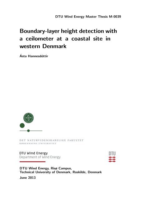
Figure 6: The single lensed optics of the <strong>ceilometer</strong> CL31 (Münkel, 2006)<br />
The laser pulse signal is reduced by absorption (extinction coefficient) and sc<strong>at</strong>tering<br />
(backsc<strong>at</strong>ter coefficient), so when solving the lidar equ<strong>at</strong>ion, there are two unknown quantities:<br />
β(z) and σ(z ′ ). The simplifying assumption is made th<strong>at</strong> there is a linear rel<strong>at</strong>ionship<br />
between extinction and backsc<strong>at</strong>ter.<br />
etition frequency, and long minimum report interval further decrease<br />
the performance of standard <strong>ceilometer</strong>s.<br />
The shortcomings of both designs are overcome by the novel<br />
optical design of the Vaisala Ceilometer CL31, shown in Figure 1.<br />
This instrument incorpor<strong>at</strong>es the advantages of both optical concepts,<br />
and the disadvantages of neither. Its fast electronics make<br />
it an all-purpose backsc<strong>at</strong>ter lidar, fit for standard <strong>ceilometer</strong><br />
tasks and air quality applic<strong>at</strong>ions. 3<br />
The right part of Figure 1 shows the enhanced single-lens design<br />
for the CL31. We use the center of the lens for collim<strong>at</strong>ing<br />
the outgoing laser beam, and the outer part to focus the backsc<strong>at</strong>tered<br />
light onto the receiver. This division between transmitting<br />
and receiving areas is provided by an inclined mirror <strong>with</strong> a hole<br />
β(z) = κσ(z) (16)<br />
where κ is called the lidar r<strong>at</strong>io and is assumed constant for a given <strong>height</strong> (Vaisala User’s<br />
Guide, 2004). It is then possible to obtain the vertical profiles of backsc<strong>at</strong>ter and extinction<br />
coefficients <strong>with</strong> the use of an inversion algorithm. It is not possible to know the exact r<strong>at</strong>io<br />
β(z)/σ(z) from the received signal, but the precise functional description is not needed to<br />
obtain useful results as st<strong>at</strong>ed by Klett (1985).<br />
Most lidars have the transmitter and receiver placed beside each other, which means th<strong>at</strong><br />
there is a zenith angle between emitted and received light Continued in the on next near page range. This produces an<br />
error in the signals th<strong>at</strong> may be corrected <strong>with</strong> an overlap function (Leosphere User Manual,<br />
2009). The <strong>ceilometer</strong> on the other hand is a single lens optical devise. Figure 6 shows<br />
the Vaisala Ceilometer CL31 and a schem<strong>at</strong>ic drawing of its optical concept. An inclined<br />
mirror <strong>with</strong> a hole in the center divides the lens into two areas. The inner area transmits the<br />
laser beam, while the outer area receives and focuses the backsc<strong>at</strong>tered light. This optical<br />
arrangement provides a full overlap of the whole measuring range, but has the disadvantage<br />
th<strong>at</strong> emitted light is partially reflected by the lens directly to the receiver, when measuring<br />
signals from the near range (Münkel, 2006).<br />
3.3 The wind LIDAR<br />
The main difference between the <strong>ceilometer</strong> and the wind lidar is th<strong>at</strong> the wind lidar relies on<br />
measurements of the Doppler shift of the backsc<strong>at</strong>tered laser pulse (Leosphere, 2008; Cariou<br />
DTU Wind Energy Master Thesis M-0039 17
occasionally use the term “radial velocity” v r or radial component of a<br />
velocity vector th<strong>at</strong> is not parallel to the line of sight. v LOS and v r are<br />
fully synonymous, <strong>with</strong> the same sign convention.<br />
Now the collective movement of air masses which we call wind<br />
is superimposed by the individual, thermal, random movement of the<br />
and Boquet, 2011). Due to the wind field, the aerosols in the <strong>at</strong>mosphere are in motion.<br />
When the light emitted by a laser hits the moving aerosol this results in a frequency shift<br />
of the light, as illustr<strong>at</strong>ed in Figure 7. The moving particle sc<strong>at</strong>ters the pulse back and the<br />
received frequency, f, is calcul<strong>at</strong>ed as:<br />
molecules. These normally move must faster than the wind speed and<br />
so much the faster the higher the temper<strong>at</strong>ure. The rel<strong>at</strong>ive shift of their<br />
velocity distribution <strong>with</strong> the wind speed is therefore small. Aerosol<br />
particles, because of theirf higher = f 0 + ∆f mass, ≃ f 0 (1 move + 2V/c) more slowly <strong>at</strong> the same (17)<br />
temper<strong>at</strong>ure and have therefore a narrower velocity distribution. They are<br />
shifted by the same amount, but rel<strong>at</strong>ive to its width this shift is much<br />
larger and amenable to measurement. The situ<strong>at</strong>ion is schem<strong>at</strong>ically<br />
shown in Fig. 12.1.<br />
where f 0 is the emitted frequency, ∆f is the frequency shift, V the wind velocity and c<br />
the speed of light.<br />
The frequency shift of the returned light is proportional to the radial component of the<br />
wind, i.e the projection of the wind velocity vector on the line-of-sight.<br />
log β<br />
-7<br />
-8<br />
-9<br />
-10<br />
-11<br />
λ0<br />
λLOS<br />
-60<br />
-30 0 +30 +60<br />
frequency (MHz)<br />
f0<br />
Fig. Figure 12.1. 7: Schem<strong>at</strong>ic Schem<strong>at</strong>ic represent<strong>at</strong>ion represent<strong>at</strong>ion of of the the original original (solid) (solid) and wind-shifted and wind-shifted (dotted) frequency (dotted)<br />
frequency distributions. distributions. If there are If there aerosols arepresent, aerosols a narrow present, spike a narrow is superimposed spike is superimposed<br />
onto the broad<br />
ontomolecular the broadpeak. molecular The return-signal peak. The return-signal frequency is shifted frequency here is toward shifted higher here toward values, indic<strong>at</strong>ing<br />
th<strong>at</strong> indic<strong>at</strong>ing the wind th<strong>at</strong> is the moving windtoward comes thetoward lidar. At the10.59 lidar. µm At 10.59 wavelength, µm wavelength, the 3-MHz shift the<br />
higher<br />
values,<br />
3-MHz corresponds shift corresponds to a wind speed to roughly of ∼20 20 m/s m/s. (Werner, 2005).<br />
The return signal of the laser pulse is processed <strong>with</strong> heterodyne principle. In heterodyne<br />
<strong>detection</strong> the return signal is mixed <strong>with</strong> a reference signal of a local oscill<strong>at</strong>or in the device,<br />
<strong>with</strong> a frequency f LO . The mixed signal contains two new frequencies, one is the sum f LO +<br />
(f 0 + ∆f), and the other the difference f LO − (f 0 + ∆f), known as the heterodyne- or be<strong>at</strong><br />
frequency. If the frequencies of the two signals are close to each other the be<strong>at</strong> signal may be<br />
determined. The detector of the device measures the current, i, of the be<strong>at</strong> frequency signal<br />
only:<br />
i = ρ √ 2P LO P (z, λ) cos[2π(f LO − (f 0 + ∆f))] (18)<br />
where ρ is the detector sensitivity [A/W], P LO is the power of the local oscill<strong>at</strong>or laser [W],<br />
f LO is the frequency of the local oscill<strong>at</strong>or laser [Hz], P (z, λ) is the power of the backsc<strong>at</strong>tered<br />
signal [W] and f 0 + ∆f the frequency of the backsc<strong>at</strong>tered signal [Hz].<br />
It is important to determine the difference between the transmitted frequency and the local<br />
oscill<strong>at</strong>or frequency <strong>with</strong> gre<strong>at</strong> accuracy. This difference is kept as stable as possible (Werner,<br />
2005).<br />
To provide inform<strong>at</strong>ion of all three wind vector components U, V and W , the lidar may<br />
scan in three or four directions. If the lines of sight are in the North, South, East and West<br />
directions, the measured radial velocities V r i are:<br />
18 DTU Wind Energy Master Thesis M-0039
V r N = U sin φ + W cos φ<br />
V r S = −U sin φ + W cos φ<br />
V r E = V sin φ + W cos φ<br />
V r W = −V sin φ + W cos φ<br />
where φ is the off-zenith-angle, or cone-angle. Subscripts, N,S,E,W indic<strong>at</strong>e the four different<br />
directions. The retrieved wind velocity components are then:<br />
(19)<br />
<br />
U = V r N − V r S<br />
2 sin φ<br />
V = V r E − V r W<br />
2 sin φ<br />
W = V r N + V r S + V r E + V r W<br />
4 cos φ<br />
(20a)<br />
(20b)<br />
(20c)<br />
Figure 8: Schem<strong>at</strong>ic <br />
of the windcube scanning technique for retrieving the wind velocity<br />
components (Cariou and Boquet, 2011).<br />
<br />
In Figure 8 is illustr<strong>at</strong>ed the principle of the lidar <br />
windcube used for estim<strong>at</strong>ing the wind<br />
<br />
velocity components, U,V and W . The reconstruction of these wind velocity components is<br />
based on the assumption of horizontal homogeneity. This assumption is valid on offshore and<br />
on fl<strong>at</strong> terrain. The off-zenith-angle φ is <br />
a trade-off between wind homogeneity and velocity<br />
resolution. Larger values of φ allow<br />
<br />
for better<br />
<br />
projections of<br />
<br />
the wind vector on each laser<br />
<br />
pulse, while smaller angles improve wind homogeneity (Cariou and Boquet, 2011).<br />
<br />
3.4 Sonic anemometer<br />
<br />
A sonic anemometer uses short pulses of ultrasonic sound waves to measure wind speed. It<br />
has three pairs of sound probes which are used<br />
altern<strong>at</strong>ely as transmitting and receiving units<br />
(transducers). In motionless air the time of flight<br />
for all three pulses is equal. A picture of the<br />
type of anemometer <strong>at</strong> the site is seen in Figure 9. <br />
In a wind field the time of flight increases for a single pulse moving upwind, and decreases<br />
<br />
downwind. If the wind field is parallel to the trajectory of the sonic pulse between one of the<br />
<br />
probe pairs, the times of flight downwind t 1 , and upwind t 2 are<br />
<br />
<br />
<br />
DTU Wind Energy Master Thesis<br />
<br />
M-0039 <br />
19
Ultrasonic Wind Sensor<br />
uSonic-3 Scientific<br />
previously USA-1<br />
High precision 3D sonic anemometer<br />
Accur<strong>at</strong>e measurement of 3 wind<br />
components<br />
Online calcul<strong>at</strong>ion of turbulence<br />
parameters<br />
Optimized by wind tunnel calibr<strong>at</strong>ion<br />
Robust stainless steel construction<br />
No moving parts, no maintenance<br />
Ice protection by efficient sensor he<strong>at</strong>ing<br />
Autom<strong>at</strong>ic system monitoring<br />
Measuring range<br />
0 ... 60 m/s , - 40 ... + 70 C<br />
Easy oper<strong>at</strong>ion via<br />
graphical user interface<br />
Figure 9: Picture of a METEK USA-1 sonic anemometer. Taken from (Metek, 2013a).<br />
s<br />
t 1 =<br />
v sound + U<br />
s<br />
t 2 =<br />
v sound − U<br />
METEK Meteorologische Messtechnik GmbH<br />
(21a)<br />
(21b)<br />
where v sound is the sound velocity, U is the wind velocity and s is the distance between<br />
the transducers (Gill-Instruments, 2013). The wind speed and the sound velocity may be<br />
calcul<strong>at</strong>ed from the changes in the time of flight.<br />
v sound = s ( 1<br />
+ 1 )<br />
(22a)<br />
2 t 1 t 2<br />
U = s ( 1<br />
− 1 )<br />
(22b)<br />
2 t 1 t 2<br />
The sound probe pairs are mounted in three different directions to provide a 3-dimensional<br />
wind vector. The sound velocity depends on temper<strong>at</strong>ure and humidity, and thus the sound<br />
velocity corresponds to a measurement of nearly virtual temper<strong>at</strong>ure (Metek, 2013b).<br />
3.5 Instrumental set-up<br />
Temper<strong>at</strong>ure and RH measurements in Høvsøre are made <strong>with</strong> a Vaisala HUMICAP temper<strong>at</strong>ure<br />
and humidity probes. Wind measurements are made <strong>with</strong> RISØ P2546 cup anemometers.<br />
Solar radi<strong>at</strong>ion is measured <strong>with</strong> a Kipp & Zonen CMP pyranometer. The Metek USA-1 sonic<br />
anemometer measures turbulent fluxes.The instrument<strong>at</strong>ion is placed on a meteorological<br />
mast.<br />
The <strong>ceilometer</strong> <strong>at</strong> Høvsøre is a Vaisala CL31. This instrument was set to return the total<br />
aerosol backsc<strong>at</strong>ter coefficient every 10 s <strong>with</strong> a 20 m vertical resolution, <strong>with</strong>in the range<br />
20–7700 m. The wavelength of the laser is 905 nm, <strong>with</strong> an energy of 1.2 µJ per pulse. For<br />
eye-safety concerns, the laser pulse of the <strong>ceilometer</strong> is not very powerful and white noise<br />
from ambient light will affect the backsc<strong>at</strong>tered signal. The influence of noise is reduced by<br />
averaging over a large number of pulses. The signal-to-noise r<strong>at</strong>io will be improved by the<br />
square root of the number of pulse repetitions, which is on average 8192 (Münkel et al., 2007).<br />
The wind lidar is a Leosphere WLS70 Windcube. The north beam of the wind lidar in<br />
Høvsøre is offset from the geographical North by 50 ◦ . The off-zenith-angle is 15 ◦ and laser<br />
pulse wavelength is 1.5 µm. The lidar measures from 100 m <strong>with</strong> 50 m <strong>height</strong> resolution. It<br />
can measure up to 2000 m, assuming aerosols are present. It measures every 10 s and reports<br />
20 DTU Wind Energy Master Thesis M-0039
only measurements where carrier to noise r<strong>at</strong>io (CNR) is above -35 dB. The laser pulse length<br />
is 400 ns and pulse energy is 20 µJ. The laser pulse length is rel<strong>at</strong>ively long, resulting in a<br />
large probe length, ∼60 m, th<strong>at</strong> influences the velocity and turbulence measurements (Mann<br />
and Peña, 2010). The wind lidar d<strong>at</strong>a used for this study is limited to signals where the CNR<br />
≥ -22 dB. This cut-off value is based on a comparison of the wind lidar measurements <strong>at</strong> 100<br />
m <strong>with</strong> the cup anemometer <strong>at</strong> 100 m in Høvsøre. The comparison shows th<strong>at</strong> the mean bias<br />
increases and the linear correl<strong>at</strong>ion decreases <strong>with</strong> CNR ≤ -22 dB (Peña et al., 2013).<br />
3.6 The Høvsøre d<strong>at</strong>abase<br />
The d<strong>at</strong>a measured <strong>with</strong> the instruments in Høvsøre is stored in a d<strong>at</strong>abase. The d<strong>at</strong>abase is<br />
accessed online <strong>with</strong> MySQL, which is a open source d<strong>at</strong>abase management system (MySQL<br />
5.1 Reference Manual, 2013). MySQL is a rel<strong>at</strong>ional d<strong>at</strong>abase, i.e. it stores d<strong>at</strong>a in separ<strong>at</strong>e<br />
tables structured and optimized for speed. Users of MySQL may manage the d<strong>at</strong>abase <strong>with</strong> a<br />
Query Browser or connect directly to a numerical computing environment, in this case M<strong>at</strong>lab.<br />
In the d<strong>at</strong>a base the d<strong>at</strong>a is sorted by the different instruments. The d<strong>at</strong>a output is in<br />
vector form <strong>with</strong> associ<strong>at</strong>ed time vectors. Wind speed (m/s) averaged over 10 minutes and<br />
direction (0-360 ◦ ) d<strong>at</strong>a is available from cup anemometers <strong>at</strong> 10, 40, 60, 80, 100 and 116 m.<br />
The RH (%) and temper<strong>at</strong>ure ( ◦ C) d<strong>at</strong>a is available <strong>at</strong> 2 and 100 m. The solar radi<strong>at</strong>ion<br />
reaching the surface is measured in W/m 2 . The sonic anemometer measures turbulent fluxes<br />
and calcul<strong>at</strong>ions of the Obukhov length (m). The wind lidar d<strong>at</strong>a output contains 10-minute<br />
mean wind components U, V, W, in m/s and the standard devi<strong>at</strong>ions of these. The total<br />
horizontal wind (m/s) and direction (0-360 ◦ ) is available as well. Furthermore carrier to noise<br />
r<strong>at</strong>io (CNR) d<strong>at</strong>a is provided.<br />
The d<strong>at</strong>a available from the Høvsøre d<strong>at</strong>abase are 10-minute average parameters, spanning<br />
April 1 2010 (the wind lidar 24 April) to March 31 2011. Backsc<strong>at</strong>ter coefficients occasionally<br />
show time duplic<strong>at</strong>es in the 10-min averages which show different backsc<strong>at</strong>ter coefficient<br />
profiles (typically 0-5 a day). Investig<strong>at</strong>ions of the duplic<strong>at</strong>es reveal th<strong>at</strong> the first profile is<br />
identical to a single 10 s profile in the same time interval, while the second profile is the<br />
expected 10 min average. Therefore the first of the time duplic<strong>at</strong>es is removed when working<br />
<strong>with</strong> the d<strong>at</strong>a.<br />
DTU Wind Energy Master Thesis M-0039 21
4 <strong>Boundary</strong>-<strong>layer</strong> <strong>height</strong> <strong>detection</strong><br />
Traditionally, BLH is derived from d<strong>at</strong>a measured <strong>with</strong> radiosondes. The radiosonde measurements<br />
provide measurements of temper<strong>at</strong>ure, dewpoint and pressure through the lower<br />
troposphere. From these measurements vertical profiles of potential temper<strong>at</strong>ure and w<strong>at</strong>er<br />
vapour mixing r<strong>at</strong>io may be <strong>at</strong>tained. The BLH is associ<strong>at</strong>ed <strong>with</strong> sharp changes in the vertical<br />
profiles and is often identified subjectively from the profiles. Objective BLH <strong>detection</strong> from<br />
radiosonde d<strong>at</strong>a exist as well and are described by Seibert et al. (1998). The BLH estim<strong>at</strong>es<br />
derived from radiosonde d<strong>at</strong>a are limited to the launch time of the radiosondes, which is<br />
typically 2–4 times a day.<br />
In this way remote sensing systems have an advantage in BLH estim<strong>at</strong>ions, as they provide<br />
continuous measurements. Besides lidar measurements, remote sensing is often performed<br />
<strong>with</strong> wind profilers or sodars. The sodar basically may be used to derive the BLH from the<br />
backsc<strong>at</strong>ter of sound waves. The intensity of the backsc<strong>at</strong>ter mainly depends on small-scale<br />
temper<strong>at</strong>ure inhomogeneities, used to derive the BLH.<br />
The wind profiler is similar to the acoustic sodar, <strong>with</strong> the main difference being its use<br />
of electromagnetic waves instead of sound waves and th<strong>at</strong> it apart from temper<strong>at</strong>ure also<br />
measures moisture inhomogeneities (Seibert et al., 1998).<br />
As mentioned, the lidar measurements rely on the aerosol concentr<strong>at</strong>ion in the <strong>at</strong>mosphere.<br />
In the ABL the aerosol concentr<strong>at</strong>ion is high compared to the free <strong>at</strong>mosphere above and this<br />
contrast is the basis for BLH <strong>detection</strong> from lidar measurements (Cohn and Angevine, 2000).<br />
It is often seen th<strong>at</strong> the aerosol content is closely rel<strong>at</strong>ed to the temper<strong>at</strong>ure profile, and the<br />
different methods therefore provide similar BLH estim<strong>at</strong>es. Even so, there may be notable differences<br />
in the thermal structure and the aerosol content as mentioned by Emeis et al. (2004).<br />
This is seen on clear days, near sunset, when a SBL starts to form near the surface, changing<br />
the temper<strong>at</strong>ure profile, while the aerosol content in the residual <strong>layer</strong> is not immedi<strong>at</strong>ely<br />
affected by this form<strong>at</strong>ion. The SBL is therefore generally detected l<strong>at</strong>er during the nighttime<br />
<strong>with</strong> aerosol measurements. Although most BLH <strong>detection</strong> methods focus on mixed <strong>layer</strong> <strong>detection</strong>,<br />
it is also possible to detect the SBL <strong>with</strong> lidars and <strong>ceilometer</strong>s (Martucci et al., 2007).<br />
When looking <strong>at</strong> an aerosol backsc<strong>at</strong>ter profile under ideal cloud free conditions during<br />
daytime, the entrainment zone and the mixed <strong>layer</strong> may clearly be seen. In these situ<strong>at</strong>ions<br />
the BLH may be identified by visual inspection. However, when the amount of backsc<strong>at</strong>ter<br />
d<strong>at</strong>a is large, this method will be time consuming. In th<strong>at</strong> case an autom<strong>at</strong>ed BLH <strong>detection</strong><br />
program will be preferable.<br />
There are numerous ways to detect the BLH from aerosol backsc<strong>at</strong>ter d<strong>at</strong>a, e.g. wavelet<br />
analyses (Davis et al., 1997), variance method (Martucci et al., 2010), the vertical gradient<br />
(Schäfer et al., 2004; Emeis et al., 2008), critical threshold (B<strong>at</strong>chvarova et al., 1999) and<br />
fitting of an ideal profile (Steyn et al., 1999). Three of the methods are presented here.<br />
4.1 The vertical gradient of the aerosol profile<br />
The vertical gradient of the backsc<strong>at</strong>ter profile is calcul<strong>at</strong>ed <strong>with</strong> a central-difference formula<br />
∂β<br />
∂z (z i) ≈ β(z i + ∆z) − β(z i − ∆z)<br />
(23)<br />
2∆z<br />
where β is the backsc<strong>at</strong>ter, z i a reference <strong>height</strong> and ∆z = 20m (from the <strong>ceilometer</strong> settings).<br />
The minimum value of the gradient often indic<strong>at</strong>es the BLH.<br />
22
1400<br />
β profile 01/05/2010 15:20<br />
1400<br />
δβ smooth<br />
/δz profile 01/05/2010 15:20<br />
1200<br />
1200<br />
1000<br />
1000<br />
Height [m]<br />
800<br />
600<br />
Height [m]<br />
800<br />
600<br />
400<br />
400<br />
200<br />
200<br />
0<br />
−50 0 50 100 150 200<br />
Backsc<strong>at</strong>ter [1/(10 8 *srad*m)]<br />
0<br />
−1 −0.5 0 0.5<br />
Backsc<strong>at</strong>ter gradient [1/(10 8 *srad*m 2 )]<br />
Figure 10: On the left: The vertical backsc<strong>at</strong>ter profile. On the right: The vertical gradient<br />
of the smoothed backsc<strong>at</strong>ter profile. Dashed line shows the BLH estim<strong>at</strong>e. D<strong>at</strong>a is from the<br />
<strong>ceilometer</strong> on May 1 2010.<br />
Fluctu<strong>at</strong>ions due to noise in the backsc<strong>at</strong>ter profile may give large noise induced gradients.<br />
These may sometimes be misinterpreted in autom<strong>at</strong>ed BLH <strong>detection</strong> programs as the BLH.<br />
These misinterpret<strong>at</strong>ions may be reduced by smoothing of the backsc<strong>at</strong>ter profile and then<br />
calcul<strong>at</strong>ing the vertical gradient of the smoothed profile. In this study the backsc<strong>at</strong>ter profile<br />
is smoothed <strong>with</strong> a moving average filter spanning 7 measuring <strong>height</strong>s before calcul<strong>at</strong>ing the<br />
gradient. The vertical gradient method is comput<strong>at</strong>ionally simple and therefore compar<strong>at</strong>ively<br />
fast in autom<strong>at</strong>ic BLH <strong>detection</strong> programs. In Figure 10 is seen the vertical backsc<strong>at</strong>ter<br />
profile along <strong>with</strong> the calcul<strong>at</strong>ed vertical gradient of the smoothed backsc<strong>at</strong>ter profile. The<br />
BLH estim<strong>at</strong>e is made where the minimum of the backsc<strong>at</strong>ter gradient is found.<br />
4.2 Critical threshold value of the aerosol profile<br />
In the ABL the aerosol concentr<strong>at</strong>ion and the backsc<strong>at</strong>ter values are rel<strong>at</strong>ively high. Therefore<br />
one method of estim<strong>at</strong>ing the BLH is by applying a critical threshold value to the backsc<strong>at</strong>ter<br />
profile. This value will lie in the transition from high backsc<strong>at</strong>ter values to low, and would best<br />
represent the BLH as approxim<strong>at</strong>ely half the mean mixed <strong>layer</strong> backsc<strong>at</strong>ter. As the mean mixed<br />
<strong>layer</strong> backsc<strong>at</strong>ter varies considerably (∼50–300/(10 8 m srad)), a constant critical value will<br />
overestim<strong>at</strong>e the BLH when aerosol concentr<strong>at</strong>ions are rel<strong>at</strong>ively high, and underestim<strong>at</strong>e, or<br />
even not estim<strong>at</strong>e the BLH <strong>at</strong> all, when aerosol concentr<strong>at</strong>ions are low.<br />
An autom<strong>at</strong>ed BLH <strong>detection</strong> algorithm is therefore developed for this study <strong>with</strong> a variable<br />
critical threshold value. The approach of the method is to define a critical threshold value,<br />
β crit and a ’maximum’ mean backsc<strong>at</strong>ter value β m . Here set to β crit = 100/(10 8 m srad)<br />
and β m =150/(10 8 m srad). The first <strong>height</strong> <strong>with</strong> backsc<strong>at</strong>ter values below β crit is then<br />
taken as a preliminary BLH estim<strong>at</strong>e. Next, the mean backsc<strong>at</strong>ter from ground level to th<strong>at</strong><br />
<strong>height</strong> is calcul<strong>at</strong>ed. If this value is above β m the BLH estim<strong>at</strong>e is used, else it is discarded<br />
and the process is repe<strong>at</strong>ed <strong>with</strong> lower β crit and β m values (here 60/(10 8 m srad) and<br />
DTU Wind Energy Master Thesis M-0039 23
90/(10 8 m srad), respectively). For very low aerosol concentr<strong>at</strong>ions these values may still<br />
prove too high, and β crit is set to 40/(10 8 m srad).<br />
The values of β crit and β m are somewh<strong>at</strong> arbitrary, and may be chosen differently. Here<br />
the values are chosen after exploring the sensitivity of the method in a variety of aerosol<br />
backsc<strong>at</strong>ter profiles.<br />
4.3 Fitting an idealized aerosol backsc<strong>at</strong>ter profile<br />
Under ideal cloudless conditions, when the ABL is well mixed, the observed backsc<strong>at</strong>ter profile<br />
will show a shape th<strong>at</strong> resembles an error function. Steyn et al. (1999) developed a method<br />
th<strong>at</strong> exploits this resemblance.<br />
The method involves minimizing the differences between an idealized backsc<strong>at</strong>ter profile<br />
B(z) and the observed backsc<strong>at</strong>ter profile β(z). The idealized backsc<strong>at</strong>ter, B, <strong>at</strong> <strong>height</strong> z is<br />
given as<br />
1400<br />
β profile 14/06/2010 10:40<br />
1200<br />
1000<br />
Height [m]<br />
800<br />
600<br />
400<br />
200<br />
0<br />
−100 0 100 200 300<br />
Backsc<strong>at</strong>ter [1/(10 8 *srad*m)]<br />
Figure 11: The vertical backsc<strong>at</strong>ter profile and the idealized profile. The profile parameters<br />
are: B m =218, B u =16 and s=79. Dashed line indic<strong>at</strong>es the BLH estim<strong>at</strong>e, z m = 553 m. D<strong>at</strong>a<br />
from the <strong>ceilometer</strong> on June 14 2010.<br />
B(z) = B m + B u<br />
2<br />
− B (<br />
m − B u z − zm<br />
erf<br />
2<br />
s<br />
where B m is the mean backsc<strong>at</strong>ter in the mixed <strong>layer</strong>, B u is the mean backsc<strong>at</strong>ter above<br />
the mixed <strong>layer</strong>, z m the mixed <strong>layer</strong> <strong>height</strong> and s is a normaliz<strong>at</strong>ion constant rel<strong>at</strong>ed to the<br />
entrainment zone thickness (EZT). The EZT is defined here to be the area where backsc<strong>at</strong>ter<br />
values drop from 0.95B m to 0.05B m . The profile parameters are determined by a nonlinear<br />
curve fitting procedure, minimizing the least squares between β(z) and B(z).<br />
min<br />
B m,B u,z m,s<br />
∑<br />
i<br />
)<br />
(<br />
)<br />
B(B m , B u , z m , s, z i ) − β(z i )<br />
(24)<br />
(25)<br />
24 DTU Wind Energy Master Thesis M-0039
An initial guess is needed for the parameters before solving the least squares. Here B u = 0<br />
and s = 30 are held constant but B m and z m are found from the critical backsc<strong>at</strong>ter method.<br />
In Figure 11 is seen an example of the idealized profile fitted to the measured aerosol<br />
backsc<strong>at</strong>ter values from the <strong>ceilometer</strong>. There is a close resemblance between the two profiles,<br />
as the conditions for BLH <strong>detection</strong> are ideal. Notice though, th<strong>at</strong> equ<strong>at</strong>ion 25 is not based<br />
on physical consider<strong>at</strong>ions, but merely applied on observ<strong>at</strong>ional grounds. This method is fairly<br />
easy to implement in autom<strong>at</strong>ic <strong>detection</strong> algorithms, but is comput<strong>at</strong>ionally heavier than the<br />
previously mentioned methods. Smoothing of the aerosol backsc<strong>at</strong>ter profile before fitting<br />
<strong>with</strong> the idealized profile does not improve the results of the method.<br />
4.4 Addition to the idealized profile<br />
The observed backsc<strong>at</strong>ter profile in Høvsøre often differs from the idealized profile, especially<br />
when the winds are westerly. Then the observed profile generally shows higher backsc<strong>at</strong>ter<br />
values near the surface. This may be because the aerosols (in this case marine aerosols),<br />
close to the surface are heavier than those immedi<strong>at</strong>ely above, and larger aerosols give higher<br />
backsc<strong>at</strong>ter values. Another reason could be th<strong>at</strong> the near-surface air is more humid.<br />
To make a better fit to the observed profile, an additional exponential term to the idealized<br />
profile is suggested in this study.<br />
B(z) = B m + B u<br />
2<br />
− B m − B u<br />
erf<br />
2<br />
( z − zm<br />
s<br />
)<br />
+ a exp(−bz) (26)<br />
where a is the initial value, and b the growth factor of the exponential function.<br />
Under certain circumstances this improved profile fits the aerosol profile better than the<br />
idealized profile, resulting in a more robust BLH <strong>detection</strong>. This is seen in Figure 12, where<br />
a fitted idealized profile is shown, both <strong>with</strong> and <strong>with</strong>out the added exponential term. The<br />
BLH estim<strong>at</strong>e <strong>with</strong> the exponential term is ∼150 m higher than the estim<strong>at</strong>e <strong>with</strong>out. The<br />
thickness of the EZT is reduced considerably by the new method, where s is found to be less<br />
than half of the value fitted by the idealized profile.<br />
The addition of the exponential term makes the non-linear curve fitting algorithm comput<strong>at</strong>ionally<br />
more intense, <strong>with</strong> two additional parameters to fit. A gre<strong>at</strong> improvement is done in<br />
the fitting process by defining lower and upper bounds on all fitted parameters. This minimizes<br />
misfits of the profile and speeds up the procedure. The method will be called the exponent<br />
idealized profile.<br />
4.5 Filtering clouds<br />
In the available <strong>ceilometer</strong> d<strong>at</strong>a, clouds are very frequently observed. Cloud droplets give very<br />
high backsc<strong>at</strong>ter values, often more than 100 to 1000 times stronger than backsc<strong>at</strong>ter values<br />
in clear sky conditions. These high values domin<strong>at</strong>e the backsc<strong>at</strong>ter profile as high peaks and<br />
the boundary-<strong>layer</strong> structure is not visible due to these peaks. The BLH <strong>detection</strong> methods<br />
are not always able to identify the BLH in cloudy conditions and they autom<strong>at</strong>ically detect<br />
the BLH <strong>at</strong> the top or the bottom of the cloud. This may cause problems in autom<strong>at</strong>ed BLH<br />
<strong>detection</strong> programs, when the cloud is well above the ABL as seen in Figure 13.<br />
Here is presented a new method to filter the clouds to gain better control of BLH <strong>detection</strong><br />
in cloudy conditions. Backsc<strong>at</strong>ter signals gre<strong>at</strong>er than 1000/(10 8 m srad) are interpreted as<br />
indic<strong>at</strong>ing clouds, fog or precipit<strong>at</strong>ion, and therefore filtered (or removed). The neighbouring<br />
backsc<strong>at</strong>ter values to the cloud, β(z cloud + ∆z), β(z cloud + 2∆z),β(z cloud − ∆z), β(z cloud −<br />
2∆z), are also removed regardless of their value. Three different methods are used to fill in<br />
the ’gap’ of removed β values.<br />
1. Every d<strong>at</strong>a point in the gap is set to zero.<br />
DTU Wind Energy Master Thesis M-0039 25
1400<br />
β profile 16/04/2010 11:40<br />
1400<br />
β profile 16/04/2010 11:40<br />
1400<br />
β profile 16/04/2010 11:40<br />
1200<br />
1200<br />
1200<br />
1000<br />
1000<br />
1000<br />
Height [m]<br />
800<br />
600<br />
Height [m]<br />
800<br />
600<br />
Height [m]<br />
800<br />
600<br />
400<br />
400<br />
400<br />
200<br />
200<br />
200<br />
0<br />
−100 0 100 200 300<br />
Backsc<strong>at</strong>ter [1/(10 8 *srad*m)]<br />
0<br />
−100 0 100 200 300<br />
Backsc<strong>at</strong>ter [1/(10 8 *srad*m)]<br />
0<br />
−100 0 100 200 300<br />
Backsc<strong>at</strong>ter [1/(10 8 *srad*m)]<br />
Figure 12: Left: The vertical backsc<strong>at</strong>ter profile (blue) <strong>with</strong> the corresponding fitted idealized<br />
profile (red). The profile parameters are: B m =237/(10 8 m srad), B u =7/(10 8 m srad),<br />
s=325 m and z m =430 m. Middle: The same backsc<strong>at</strong>ter profile (blue) <strong>with</strong> the corresponding<br />
fitted exponent idealized profile (magenta). The improved profile parameters are:<br />
B m =151/(10 8 m srad), B u =10/(10 8 m srad), s=150 m, z m =555 m, a=167 and b=0.01.<br />
Right: The backsc<strong>at</strong>ter profile (blue) and the exponent idealized profile split into the exponent<br />
contribution (green) and the idealized profile (red). D<strong>at</strong>a from the <strong>ceilometer</strong> on April<br />
16 2010.<br />
2000<br />
! profile 17/05/2010 19:50<br />
2000<br />
! profile 17/05/2010 19:50<br />
1800<br />
1800<br />
1600<br />
1600<br />
1400<br />
1400<br />
1200<br />
1200<br />
Height [m]<br />
1000<br />
Height [m]<br />
1000<br />
800<br />
800<br />
600<br />
600<br />
400<br />
400<br />
200<br />
200<br />
0<br />
−5000 0 5000 10000 15000<br />
Backsc<strong>at</strong>ter [1/(10 8 *srad*m)]<br />
0<br />
−100 0 100 200 300 400 500<br />
Backsc<strong>at</strong>ter [1/(10 8 *srad*m)]<br />
(a)<br />
(b)<br />
Figure 13: (a): Aerosol backsc<strong>at</strong>ter profile, <strong>with</strong> a decoupled cloud well above the ABL. The<br />
cloud base is <strong>at</strong> ∼1100 m. The cloud signal peaks <strong>at</strong> ∼ 13000/(10 8 m srad). (b): Zooming<br />
in on the β-profile reveals the boundary-<strong>layer</strong> structure around ∼400 m.<br />
26 DTU Wind Energy Master Thesis M-0039
2. An interpol<strong>at</strong>ion between the non-removed values. Either linear- or nearest neighbour<br />
interpol<strong>at</strong>ion 5 may be used.<br />
3. Every d<strong>at</strong>a point in the gap is set to the cloud base value.<br />
1600<br />
Zero filter<br />
23/07/2010 22:00<br />
Linear interpol<strong>at</strong>ion<br />
1600<br />
1600<br />
Cloud base filter<br />
1400<br />
1400<br />
1400<br />
1200<br />
1200<br />
1200<br />
1000<br />
1000<br />
1000<br />
Height [m]<br />
800<br />
Height [m]<br />
800<br />
Height [m]<br />
800<br />
600<br />
600<br />
600<br />
400<br />
400<br />
400<br />
200<br />
200<br />
200<br />
0<br />
0 100 200<br />
Backsc<strong>at</strong>ter [1/(10 8 *srad*m)]<br />
0<br />
0 100 200<br />
Backsc<strong>at</strong>ter [1/(10 8 *srad*m)]<br />
0<br />
0 100 200<br />
Backsc<strong>at</strong>ter [1/(10 8 *srad*m)]<br />
Figure 14: A cloud topped ABL showing the three different cloud filtering methods.<br />
These three filtering methods can be seen in Figure 14. If there is fog an extrapol<strong>at</strong>ion is<br />
made from the first above ground ’non-removed ’ β value.<br />
As mentioned in section 2.7, it is a m<strong>at</strong>ter of definition where to identify the BLH in<br />
a CTBL. But <strong>with</strong> these three different filtering methods it is possible to detect the BLH<br />
m<strong>at</strong>ching the chosen definition of the CTBL.<br />
The cloud definition value β(z) = 1000 is chosen rel<strong>at</strong>ively high to ensure the presence of<br />
a cloud. A lower value of cloud definition β(z) = 800 has been tested, <strong>with</strong> no noticeable<br />
differences from the higher value.<br />
4.6 Minimum turbulence kinetic energy<br />
The wind lidar provides measures of wind velocity fluctu<strong>at</strong>ions. These are given as the standard<br />
devi<strong>at</strong>ions of the mean wind velocity components σ u , σ v and σ w and may be used to<br />
calcul<strong>at</strong>e the TKE of the wind field <strong>with</strong> equ<strong>at</strong>ion 3. The TKE approaches zero <strong>at</strong> the top of<br />
the ABL as the wind velocity fluctu<strong>at</strong>ions are small in the laminar flow above the ABL. The<br />
BLH may therefore be estim<strong>at</strong>ed as the <strong>height</strong> where the TKE drops below a critical value<br />
(Vickers and Mahrt, 2004).<br />
Figure 15 shows the vertical profiles of σ u , σ v and σ w and the associ<strong>at</strong>ed vertical profile<br />
of the TKE. The <strong>height</strong> of the wind lidar measurements is limited by the <strong>height</strong> of the<br />
aerosol content in the <strong>at</strong>mosphere, leading to <strong>height</strong> limited vertical profiles of σ u , σ v and<br />
σ w . Therefore the minimum value of the TKE is used as a BLH estim<strong>at</strong>e in this study, instead<br />
of defining a critical value. If there are more than one equal minimum values the lowest one<br />
is used as a BLH estim<strong>at</strong>e.<br />
5 The nearest neighbour method takes the value of the nearest point only, yielding a piecewise interpol<strong>at</strong>ion.<br />
DTU Wind Energy Master Thesis M-0039 27
24/04/2010 06:20<br />
1000<br />
σ w<br />
1000<br />
ē<br />
900<br />
σ u<br />
900<br />
σ v<br />
800<br />
800<br />
700<br />
700<br />
Height [m]<br />
600<br />
500<br />
Height<br />
600<br />
500<br />
400<br />
400<br />
300<br />
300<br />
200<br />
200<br />
100<br />
0 0.2 0.4 0.6 0.8<br />
Std [m/s]<br />
100<br />
0.1 0.2 0.3 0.4 0.5 0.6<br />
TKE [m 2 /s 2 ]<br />
Figure 15: Left: The vertical profiles of the wind velocity fluctu<strong>at</strong>ions. Right: The vertical<br />
profile of the calcul<strong>at</strong>ed TKE. D<strong>at</strong>a is from the wind lidar on April 24 2010.<br />
28 DTU Wind Energy Master Thesis M-0039
5 Results<br />
5.1 Clouds<br />
A simple estim<strong>at</strong>e of cloud cover is made from the <strong>ceilometer</strong> d<strong>at</strong>a. Every time the backsc<strong>at</strong>ter<br />
signal exceeds 1000/(10 8 m srad), the algorithm indic<strong>at</strong>es either cloud or fog and the time<br />
step is noted as a cloud observ<strong>at</strong>ion. As mentioned in section 3 the <strong>ceilometer</strong> measurements<br />
cover the period from April 2010 to March 2011 <strong>with</strong> 10 s time resolution. From the analysis<br />
of the 10 min d<strong>at</strong>a stored in the d<strong>at</strong>abase, it is seen th<strong>at</strong> 58 % of the time the presence of<br />
clouds is detected <strong>with</strong>in the vertical range of 200 – 3000 m. The starting <strong>height</strong> of 200 m is<br />
chosen to avoid mist events th<strong>at</strong> give very high backsc<strong>at</strong>ter values <strong>at</strong> the lowest measuring<br />
<strong>height</strong>s.<br />
2000<br />
! profile 17/05/2010 Smoothed**profile 19:50 17/05/2010 19:50<br />
2000<br />
2000<br />
smooth<br />
/z profile 17/05/2010 19:50<br />
1800<br />
1800<br />
1800<br />
1600<br />
1600<br />
1600<br />
1400<br />
1400<br />
1400<br />
1200<br />
1200<br />
1200<br />
Height [m]<br />
1000<br />
Height [m]<br />
1000<br />
Height [m]<br />
1000<br />
800<br />
800<br />
800<br />
600<br />
600<br />
600<br />
400<br />
400<br />
400<br />
200<br />
200<br />
200<br />
0<br />
0<br />
−500 0 5000 1000 0 1500 5000 10000<br />
Backsc<strong>at</strong>ter [1/(10 8 *srad*m)] Backsc<strong>at</strong>ter [1/(10 8 srad m)]<br />
(a)<br />
0<br />
100 50 0 50 100<br />
Backsc<strong>at</strong>ter gradient [1/(10 8 *srad*m 2 )]<br />
(b)<br />
Figure 16: Left: Blue line indic<strong>at</strong>es the backsc<strong>at</strong>ter profile, while the red line indic<strong>at</strong>es the<br />
fitted idealized profile. The high values in the backsc<strong>at</strong>ter <strong>at</strong> ∼1100–1300 m indic<strong>at</strong>e a cloud<br />
<strong>layer</strong>. The profile peaks <strong>at</strong> 13000/(10 8 m srad). Right: The vertical gradient of the smoothed<br />
backsc<strong>at</strong>ter profile. Backsc<strong>at</strong>ter values peak <strong>at</strong> <strong>height</strong> 1200 m. Horizontal dashed lines indic<strong>at</strong>e<br />
estim<strong>at</strong>ed BLH. D<strong>at</strong>a is from the <strong>ceilometer</strong> on May 17 2010 <strong>at</strong> 19:50.<br />
29
Decoupled Clouds<br />
Clouds th<strong>at</strong> are not boundary-<strong>layer</strong> clouds, i.e. those th<strong>at</strong> are decoupled from the ABL or well<br />
above it, still influence the BLH <strong>detection</strong>. As seen in Figure 16 the cloud signal domin<strong>at</strong>es the<br />
backsc<strong>at</strong>ter profile where the highest signals are ∼ 13000/(10 8 m srad). Both the fitting of<br />
the idealized profile seen in Figure 16(a) and the vertical gradient of the smoothed backsc<strong>at</strong>ter<br />
seen in Figure 16(b) fail to detect the BLH th<strong>at</strong> is seen to be <strong>at</strong> ∼400 m. The idealized profile<br />
method finds the minimized differences by identifying the BLH <strong>at</strong> the cloud base <strong>at</strong> ∼1110 m.<br />
The vertical gradient method identifies the BLH <strong>at</strong> the cloud top <strong>at</strong> ∼1250 m.<br />
17/05/2010 19:50<br />
1600<br />
Zero filter<br />
1600<br />
Linear interpol<strong>at</strong>ion<br />
1600<br />
Cloud base filter<br />
1400<br />
1400<br />
1400<br />
1200<br />
1200<br />
1200<br />
1000<br />
1000<br />
1000<br />
Height [m]<br />
800<br />
Height [m]<br />
800<br />
Height [m]<br />
800<br />
600<br />
600<br />
600<br />
400<br />
400<br />
400<br />
200<br />
200<br />
200<br />
0 100 200<br />
Backsc<strong>at</strong>ter [1/(10 8 *srad*m)]<br />
0 100 200<br />
Backsc<strong>at</strong>ter [1/(10 8 *srad*m)]<br />
0 100 200<br />
Backsc<strong>at</strong>ter [1/(10 8 *srad*m)]<br />
Figure 17: Plots of three different cloud filtering methods <strong>with</strong> associ<strong>at</strong>ed fitting of the<br />
idealized profile. Blue lines indic<strong>at</strong>e backsc<strong>at</strong>ter profile while red lines indic<strong>at</strong>e idealized profile.<br />
Horizontal dotted lines indic<strong>at</strong>e BLH estim<strong>at</strong>es. D<strong>at</strong>a taken from the <strong>ceilometer</strong> May 17 2010<br />
<strong>at</strong> 19:50.<br />
Filtering decoupled clouds improves the BLH <strong>detection</strong> significantly. This is seen in Figure<br />
17 showing three different cloud filtering methods (the zero filter, linear interpol<strong>at</strong>ion and<br />
cloud base filter) and the idealized profile BLH <strong>detection</strong> method. This figure shows the same<br />
backsc<strong>at</strong>ter profile as in Figure 16 only <strong>with</strong> the cloud filtering applied. The cloud signal does<br />
not domin<strong>at</strong>e the backsc<strong>at</strong>ter profile any longer and the idealized profile now makes a better<br />
fit, identifying the BLH right above 400 m.<br />
It is seen in Figure 17 th<strong>at</strong> the BLH estim<strong>at</strong>es are independent of the chosen cloud filtering<br />
method. This is because in this case the cloud is ∼700 m above the detected ABL. However<br />
in conditions <strong>with</strong> a cloud topped ABL, the chosen cloud filtering method will influence the<br />
BLH estim<strong>at</strong>e of all methods.<br />
The cloud topped boundary <strong>layer</strong><br />
In situ<strong>at</strong>ions <strong>with</strong> a CTBL, the BLH <strong>detection</strong> methods often detect the BLH <strong>at</strong> the top<br />
of the cloud. This might not always cause wrong <strong>detection</strong>s, depending on the chosen BLH<br />
definition <strong>with</strong> a cloud topped boundary <strong>layer</strong>. As mentioned in section 2.7 when a CTBL is<br />
30 DTU Wind Energy Master Thesis M-0039
observed and the cloud <strong>layer</strong> and boundary <strong>layer</strong> are turbulently fully coupled then defining<br />
the BLH <strong>at</strong> the top of the cloud may be preferable. When working <strong>with</strong> <strong>ceilometer</strong> d<strong>at</strong>a alone,<br />
it cannot be determined if the two <strong>layer</strong>s are fully coupled and it may be convenient to define<br />
the BLH in another manner than <strong>at</strong> the cloud top.<br />
1600<br />
Zero filter<br />
23/07/2010 22:00<br />
Nearest−neighbour interpol<strong>at</strong>ion<br />
1600<br />
1600<br />
Cloud base filter<br />
1400<br />
1400<br />
1400<br />
1200<br />
1200<br />
1200<br />
1000<br />
1000<br />
1000<br />
Height [m]<br />
800<br />
Height [m]<br />
800<br />
Height [m]<br />
800<br />
600<br />
600<br />
600<br />
400<br />
400<br />
400<br />
200<br />
200<br />
200<br />
0<br />
0 100 200<br />
Backsc<strong>at</strong>ter [1/(10 8 *srad*m)]<br />
0<br />
0 100 200<br />
Backsc<strong>at</strong>ter [1/(10 8 *srad*m)]<br />
0<br />
0 100 200<br />
Backsc<strong>at</strong>ter [1/(10 8 *srad*m)]<br />
Figure 18: Three different cloud filtering methods applied to the backsc<strong>at</strong>ter profile. The blue<br />
line is the backsc<strong>at</strong>ter profile, while the red line is the idealized profile. Dotted horizontal lines<br />
indic<strong>at</strong>e the estim<strong>at</strong>ed BLH. D<strong>at</strong>a is from July 23 2010 <strong>at</strong> 22:00.<br />
The cloud filtering methods allow the BLH <strong>detection</strong> algorithm to gain better control<br />
over the aerosol backsc<strong>at</strong>ter profile under the presence of clouds and determine the BLH<br />
according to the chosen BLH <strong>detection</strong> method. Figure 18 shows the idealized profile fitted<br />
to a backsc<strong>at</strong>ter profile, where clouds were filtered <strong>with</strong> three different methods. In Figure 18<br />
(left) the zero filter is applied, setting all signals in the cloud <strong>layer</strong> to zero. This results in a<br />
sharp decrease in the backsc<strong>at</strong>ter <strong>at</strong> the cloud base and the BLH <strong>detection</strong> methods generally<br />
identify the BLH in such a sharp transition. In this case the BLH estim<strong>at</strong>e is ∼400 m.<br />
In Figure 18 (middle) the signals in the cloud <strong>layer</strong> were filtered <strong>with</strong> nearest neighbour<br />
interpol<strong>at</strong>ion, resulting in a sharp transition in the middle of the cloud <strong>layer</strong>. This filtering<br />
method proposes the BLH <strong>detection</strong> methods estim<strong>at</strong>e the BLH in the middle of the cloud,<br />
corresponding well <strong>with</strong> a BLH definition tre<strong>at</strong>ing the cloud <strong>layer</strong> as an entrainment zone.<br />
Cloud filtering <strong>with</strong> linear interpol<strong>at</strong>ion gives similar results as the nearest neighbour interpol<strong>at</strong>ion,<br />
though the BLH estim<strong>at</strong>es tend to be slightly higher <strong>with</strong> the linear interpol<strong>at</strong>ion.<br />
Here the BLH estim<strong>at</strong>e is ∼550 m. Figure 18 (right) shows the cloud base filtering, where the<br />
signals in the cloud are set to the same backsc<strong>at</strong>ter value as the cloud base. With this filtering<br />
method the BLH estim<strong>at</strong>es are detected <strong>at</strong> the cloud top. Here the BLH estim<strong>at</strong>e is ∼750 m.<br />
The BLH estim<strong>at</strong>es <strong>with</strong> the cloud base filter mostly give the same results in a CTBL case<br />
as no filtering <strong>at</strong> all, especially when using the vertical gradient and the threshold methods.<br />
However the cloud filtering gives better control of the d<strong>at</strong>a and the profile fitting methods<br />
are improved. As seen in Figure 16(a) the profile fitting methods do not always detect the<br />
BLH <strong>at</strong> the cloud top.<br />
DTU Wind Energy Master Thesis M-0039 31
1600<br />
Zero filter<br />
23/07/2010 22:00<br />
Nearest−neighbour interpol<strong>at</strong>ion<br />
1600<br />
1600<br />
Cloud base filter<br />
1400<br />
1400<br />
1400<br />
1200<br />
1200<br />
1200<br />
1000<br />
1000<br />
1000<br />
Height [m]<br />
800<br />
Height [m]<br />
800<br />
Height [m]<br />
800<br />
600<br />
600<br />
600<br />
400<br />
400<br />
400<br />
200<br />
200<br />
200<br />
−1.5 −1 −0.5 0<br />
Backsc<strong>at</strong>ter gradient [1/(10 8 *srad*m 2 )]<br />
−1 −0.5 0<br />
Backsc<strong>at</strong>ter gradient [1/(10 8 *srad*m 2 )]<br />
−1 −0.5 0<br />
Backsc<strong>at</strong>ter gradient [1/(10 8 *srad*m 2 )]<br />
Figure 19: The vertical gradient of the smoothed backsc<strong>at</strong>ter profile <strong>with</strong> three different cloud<br />
filtering methods. The dashed horizontal line indic<strong>at</strong>es the BLH estim<strong>at</strong>e from the method.<br />
D<strong>at</strong>a is from the <strong>ceilometer</strong> on July 23 2010 <strong>at</strong> 22:00.<br />
Figure 19 shows the vertical gradient of the smoothed backsc<strong>at</strong>ter profile <strong>with</strong> three different<br />
cloud filtering methods. The vertical gradients are calcul<strong>at</strong>ed from the same profiles as shown<br />
in Figure 18 <strong>with</strong> the same cloud filtering. In the left figure the BLH is estim<strong>at</strong>ed <strong>at</strong> ∼450 m,<br />
approxim<strong>at</strong>ely 50 m higher than compared to the idealized profile. In the middle figure the<br />
BLH is estim<strong>at</strong>ed <strong>at</strong> ∼550 m, approxim<strong>at</strong>ely the same <strong>height</strong> as the idealized profile. In the<br />
right figure the BLH estim<strong>at</strong>ed <strong>at</strong> ∼750 m, approxim<strong>at</strong>ely 50 m higher than the idealized<br />
profile. These differences are due to the smoothing of the backsc<strong>at</strong>ter profile before BLH<br />
<strong>detection</strong> <strong>with</strong> the vertical gradient method.<br />
Figure 20 shows the backsc<strong>at</strong>ter intensities on August 19 2010. A CTBL is observed <strong>with</strong><br />
varying cloud thickness of 100–800 m. All BLH estim<strong>at</strong>es are made <strong>with</strong> the critical threshold<br />
<strong>detection</strong> method, but three different cloud filtering methods are used for the estim<strong>at</strong>es. The<br />
BLH estim<strong>at</strong>e <strong>with</strong> zero filter (black circles) follow the cloud base. The nearest neighbour<br />
interpol<strong>at</strong>ion (green triangles) generally show a BLH in the middle of the cloud, though a few<br />
are <strong>at</strong> the top, coinciding <strong>with</strong> the pink stars. In these situ<strong>at</strong>ions the cloud top is diffuse and<br />
the top and bottom values th<strong>at</strong> the interpol<strong>at</strong>ion is made between are of similar size. The<br />
BLH estim<strong>at</strong>es performed <strong>with</strong> the cloud base filtering method follow the cloud top.<br />
It is seen from Figure 20 th<strong>at</strong> BLH estim<strong>at</strong>es made on backsc<strong>at</strong>ter profiles <strong>with</strong> zero cloud<br />
filtering applied, show the least vari<strong>at</strong>ion in <strong>height</strong>. These estim<strong>at</strong>es vary between ∼400–<br />
700 m following the cloud base. The cloud top <strong>height</strong> on the other hand changes rapidly <strong>with</strong><br />
the cloud thickness, where the cloud top varies between ∼700 m and ∼1400 m, resulting in<br />
fluctu<strong>at</strong>ing BLH estim<strong>at</strong>es.<br />
32 DTU Wind Energy Master Thesis M-0039
1600<br />
BLH, critical threshold, different cloud filtering<br />
400<br />
1400<br />
350<br />
1200<br />
300<br />
Height [m]<br />
1000<br />
800<br />
600<br />
250<br />
200<br />
150<br />
β [1/(10 8 ⋅srad⋅m)]<br />
400<br />
100<br />
200<br />
50<br />
06:00 09:00 12:00 15:00 18:00 21:00<br />
Time of day<br />
0<br />
Figure 20: The backsc<strong>at</strong>ter coefficient measured <strong>with</strong> the <strong>ceilometer</strong> on August 19 2010. The<br />
coloured shading indic<strong>at</strong>es the intensity of the backsc<strong>at</strong>tered light, blue shading indic<strong>at</strong>es<br />
minimal sc<strong>at</strong>tering and white indic<strong>at</strong>es neg<strong>at</strong>ive backsc<strong>at</strong>ter values. All BLH estim<strong>at</strong>es are<br />
made <strong>with</strong> the critical threshold method and three different cloud filtering methods are applied.<br />
The black circles indic<strong>at</strong>e zero filter, green triangles indic<strong>at</strong>e nearest neighbour interpol<strong>at</strong>ion<br />
and pink stars indic<strong>at</strong>e the cloud base filter.<br />
DTU Wind Energy Master Thesis M-0039 33
5.2 Continuous and average d<strong>at</strong>a<br />
The <strong>ceilometer</strong> <strong>at</strong> Høvsøre provides measurements of the aerosol backsc<strong>at</strong>ter every ten seconds<br />
(henceforth, 10 s d<strong>at</strong>a). These d<strong>at</strong>a are not readily available on the Høvsøre d<strong>at</strong>abase, but<br />
remain stored <strong>at</strong> the Risø met d<strong>at</strong>a server. The ten minute means (henceforth, 10 min d<strong>at</strong>a)<br />
of these high resolution d<strong>at</strong>a are as mentioned in section 3 available on the d<strong>at</strong>abase.<br />
To compare the BLH estim<strong>at</strong>es of 10 min d<strong>at</strong>a <strong>with</strong> those of the 10 s d<strong>at</strong>a, BLH estim<strong>at</strong>es<br />
are made for every 10 s d<strong>at</strong>a during a ten minute interval for a single whole day. The mean<br />
of these 60 estim<strong>at</strong>es is calcul<strong>at</strong>ed (henceforth, 10 s mean BLH) and compared to the 10 min<br />
d<strong>at</strong>a BLH estim<strong>at</strong>es.<br />
600<br />
Exponent idealized profile<br />
400<br />
550<br />
500<br />
450<br />
350<br />
300<br />
Height [m]<br />
400<br />
350<br />
300<br />
250<br />
250<br />
200<br />
150<br />
β [1/(10 8 *srad*m)]<br />
200<br />
150<br />
100<br />
100<br />
50<br />
50<br />
00:00 03:00 06:00 09:00 12:00 15:00 18:00 21:00<br />
Time of day<br />
0<br />
Figure 21: The diurnal evolution of the ABL on June 21 2010. The BLH estim<strong>at</strong>es are found<br />
by fitting the exponent idealized profile. Black stars indic<strong>at</strong>e the BLH estim<strong>at</strong>es from the 10<br />
min d<strong>at</strong>a and magenta stars the BLH estim<strong>at</strong>es from the 10 s mean BLH. The error bars<br />
represent the standard devi<strong>at</strong>ion of the 10 s estim<strong>at</strong>es <strong>with</strong>in 10 minutes.<br />
In Figure 21 the BLH estim<strong>at</strong>es from the different d<strong>at</strong>a types, 10 s and 10 min, are illustr<strong>at</strong>ed<br />
for an entire day, starting <strong>at</strong> midnight. These BLH estim<strong>at</strong>es have all been performed by fitting<br />
the exponent idealized profile described in Section 4.4. It should be noted th<strong>at</strong> the error<br />
bars shown are not exact errors, but the BLH variability, found by computing the standard<br />
devi<strong>at</strong>ion, σ of all 10 s BLH estim<strong>at</strong>es <strong>with</strong>in 10 minutes. It is seen th<strong>at</strong> the variability is<br />
generally larger during daytime, from around 7:00 to 16:00, than during nighttime, from<br />
00:00 to 07:00. The standard devi<strong>at</strong>ion of the BLH estim<strong>at</strong>es is largest in the l<strong>at</strong>e evening<br />
from 20:00 to 22:00, where the backsc<strong>at</strong>ter signal is rel<strong>at</strong>ively weak. The cloud visible from<br />
around 23:00 has been removed <strong>with</strong> the cloud base filter described in Section 4.5. The BLH<br />
estim<strong>at</strong>es from the two d<strong>at</strong>a sets agree very well, though <strong>with</strong> a tendency in the 10 min d<strong>at</strong>a<br />
estim<strong>at</strong>es to be a little higher, especially during daytime. This is common for all four methods<br />
of BLH <strong>detection</strong>, and may be seen in appendix B where plots similar to Figure 21 are made<br />
for the remaining three <strong>detection</strong> methods.<br />
Figure 22 shows a sc<strong>at</strong>ter plot of the 10 min BLH estim<strong>at</strong>es and those 10 min means derived<br />
from the 10 s estim<strong>at</strong>es from the four different BLH <strong>detection</strong> methods. As in Figure 21 the<br />
34 DTU Wind Energy Master Thesis M-0039
10min mean BLH [m] 10sec−d<strong>at</strong>a<br />
10min mean BLH [m] 10sec−d<strong>at</strong>a<br />
450<br />
400<br />
350<br />
300<br />
250<br />
Idealized profile<br />
200<br />
N = 144<br />
150<br />
R = 0.99<br />
100<br />
Slope = 0.96<br />
100 200 300 400<br />
BLH [m] 10min−mean−d<strong>at</strong>a<br />
450<br />
400<br />
350<br />
300<br />
250<br />
Vertical gradient<br />
200<br />
N = 144<br />
150<br />
R = 0.94<br />
100<br />
Slope = 0.88<br />
100 200 300 400<br />
BLH [m] 10min−mean−d<strong>at</strong>a<br />
10min mean BLH [m] 10sec−d<strong>at</strong>a<br />
10min mean BLH [m] 10sec−d<strong>at</strong>a<br />
Exponent−Idealized profile<br />
450<br />
400<br />
350<br />
300<br />
250<br />
200<br />
N = 144<br />
150<br />
R = 0.99<br />
100<br />
Slope = 0.95<br />
100 200 300 400<br />
BLH [m] 10min−mean−d<strong>at</strong>a<br />
450<br />
400<br />
350<br />
300<br />
250<br />
Critical threshold<br />
200<br />
N = 144<br />
150<br />
R = 0.98<br />
100<br />
Slope = 0.96<br />
100 200 300 400<br />
BLH [m] 10min−mean−d<strong>at</strong>a<br />
Figure 22: Sc<strong>at</strong>ter plots of BLH estim<strong>at</strong>es from 10 s d<strong>at</strong>a for June 21 2010 using the various<br />
BLH <strong>detection</strong> methods. Error bars represent the standard devi<strong>at</strong>ion of BLH estim<strong>at</strong>es <strong>with</strong>in<br />
10 minutes. N = number of estim<strong>at</strong>es, R = correl<strong>at</strong>ion coefficient, Slope = the slope of the<br />
linear regression (a). Dashed line is the linear regression. Blue solid line is the 1:1 line.<br />
Method RMSD [m] Mean σ [m]<br />
Idealized profile 10 21<br />
Exp. ideal. profile 10 19<br />
Vertical gradient 23 48<br />
Critical threshold 12 21<br />
Table 2: Root mean square devi<strong>at</strong>ion and the mean standard devi<strong>at</strong>ion of the different BLH<br />
<strong>detection</strong> methods for 10 s d<strong>at</strong>a, June 21 2010.<br />
error bars represent the standard devi<strong>at</strong>ion of the BLH estim<strong>at</strong>es from the 10 s d<strong>at</strong>a <strong>with</strong>in 10<br />
minutes. The slopes are calcul<strong>at</strong>ed by a simple linear regression <strong>with</strong> a least square estim<strong>at</strong>or.<br />
The slopes are all less than 1, indic<strong>at</strong>ing the tendency for the BLH estim<strong>at</strong>es from the 10<br />
min d<strong>at</strong>a to generally be a little higher as mentioned above. All four methods show excellent<br />
correl<strong>at</strong>ion between the d<strong>at</strong>a, <strong>with</strong> the lowest correl<strong>at</strong>ion of 0.94. These high correl<strong>at</strong>ions are<br />
also expected, as the d<strong>at</strong>a sets (10 s and 10 min) are not independent. The critical threshold<br />
and the vertical gradient methods depend on the <strong>height</strong> resolution (in this case 20 m). For<br />
this reason the BLH estim<strong>at</strong>es for the 10 min d<strong>at</strong>a appear as discretized, while the 10 s d<strong>at</strong>a<br />
mean BLH estim<strong>at</strong>es vary more smoothly over <strong>height</strong>. Thus many values in the figure are<br />
difficult to distinguish as crosses and error bars are on top of each other. The profile fitting<br />
methods on the other hand are independent of the <strong>height</strong> resolution, estim<strong>at</strong>ing the BLH in<br />
the middle of the apparent interfacial <strong>layer</strong>.<br />
Table 2 shows the root mean square devi<strong>at</strong>ions (RMSD) between the BLH estim<strong>at</strong>es from<br />
10 min d<strong>at</strong>a and the 10 s d<strong>at</strong>a mean BLH estim<strong>at</strong>es. The mean σ is simply the averaged size<br />
DTU Wind Energy Master Thesis M-0039 35
of the error bars during the day. The two profile fitting methods have the lowest RMSD, 10 m<br />
and the exponent idealized profile method shows the lowest mean σ. The method showing<br />
largest σ is the vertical gradient, also <strong>with</strong> the largest RMSD.<br />
1000<br />
10 sec. backsc<strong>at</strong>ter profiles<br />
1000<br />
10 min. mean backsc<strong>at</strong>ter profile<br />
900<br />
900<br />
800<br />
800<br />
700<br />
700<br />
600<br />
600<br />
Height [m]<br />
500<br />
Height [m]<br />
500<br />
400<br />
400<br />
300<br />
300<br />
200<br />
200<br />
100<br />
100<br />
0 100 200 300<br />
Backsc<strong>at</strong>ter [1/(10 8 *srad*m 2 )]<br />
0 100 200 300<br />
Backsc<strong>at</strong>ter [1/(10 8 *srad*m 2 )]<br />
Figure 23: On the left: Vertical backsc<strong>at</strong>ter profiles measured every 10 seconds from 00:40 to<br />
00:50. Every third profile is shown. On the right: The average of the sixty 10 s profiles from<br />
00:40 to 00:50. With error bars representing the standard devi<strong>at</strong>ion of the backsc<strong>at</strong>ter signal<br />
<strong>at</strong> every measured <strong>height</strong>. The BLH is seen to be around 300 m.<br />
Method BLH [m] 10min d<strong>at</strong>a Mean BLH [m] 10s d<strong>at</strong>a σ [m]<br />
Idealized profile 288 276 24<br />
Exp. ideal. profile 295 294 7<br />
Vertical gradient 260 275 40<br />
Critical threshold 300 307 10<br />
Table 3: BLH <strong>detection</strong> between 00:40 and 00:50, showing the results for the four methodologies.<br />
To further compare the 10 min d<strong>at</strong>a <strong>with</strong> the 10 s d<strong>at</strong>a, two 10 minute intervals from<br />
the day are chosen for plotting the vertical profile of the backsc<strong>at</strong>ter. The first interval is<br />
from 00:40 to 00:50, during nighttime. The vertical profiles are seen in Figure 23. The left<br />
plot shows the vertical 10 s backsc<strong>at</strong>ter profiles 6 while the right plot shows the rel<strong>at</strong>ed<br />
mean backsc<strong>at</strong>ter profile. The standard devi<strong>at</strong>ion of the signal <strong>with</strong>in 10 minutes is shown as<br />
horizontal error bars on the right plot. It is noteworthy how little variability there is in the<br />
signal immedi<strong>at</strong>ely above the ABL, and generally higher devi<strong>at</strong>ion of the signal <strong>with</strong>in the<br />
ABL, especially in the transition zone. Above the ABL the standard devi<strong>at</strong>ion of the signal<br />
increases <strong>with</strong> <strong>height</strong> due to noise, as the measured signal strength is inversely proportional<br />
to the squared <strong>height</strong> as seen in equ<strong>at</strong>ion 15.<br />
Table 3 shows the rel<strong>at</strong>ed BLH estim<strong>at</strong>es from the 10 min and the 10 s d<strong>at</strong>a, together <strong>with</strong><br />
the standard devi<strong>at</strong>ion of the 10 s BLH estim<strong>at</strong>es, between 00:40 and 00:50. The vertical pro-<br />
6 Only every third profile is shown for better visualiz<strong>at</strong>ion.<br />
36 DTU Wind Energy Master Thesis M-0039
files show a shape th<strong>at</strong> fits well <strong>with</strong> the exponent idealized profile, i.e increasing backsc<strong>at</strong>ter<br />
values from ∼ 100 m down to the surface. The exponent idealized profile method detects the<br />
BLH <strong>with</strong> the least σ, only differing one meter between the 10 min and 10 s d<strong>at</strong>a.<br />
The second time interval is chosen from 09:00 to 09:10 during daytime. In Figure 24 is<br />
shown plots analogous to those seen in Figure 23 for this second time interval. The error of<br />
the signal is gre<strong>at</strong>er during the daytime as the ambient sunlight influences the light <strong>detection</strong><br />
of the <strong>ceilometer</strong>’s laser among others. This is seen by the standard devi<strong>at</strong>ions both above<br />
and <strong>with</strong>in the ABL being gre<strong>at</strong>er than those seen during nighttime. The standard devi<strong>at</strong>ion<br />
of the BLH estim<strong>at</strong>es is also noticeably larger during daytime as may be seen in Table 4, <strong>with</strong><br />
values up to 6 times larger than during nighttime (for the exponent ideal profile method).<br />
Hennemuth and Lammert (2006) noted th<strong>at</strong> this variability may be caused by single convective<br />
eddies <strong>with</strong> a time scale of a few minutes. The variability might also be caused by gravity- or<br />
Kelvin-Helmholtz waves.<br />
1000<br />
10 sec. backsc<strong>at</strong>ter profiles<br />
1000<br />
10 min. mean backsc<strong>at</strong>ter profile<br />
900<br />
900<br />
800<br />
800<br />
700<br />
700<br />
600<br />
600<br />
Height [m]<br />
500<br />
Height [m]<br />
500<br />
400<br />
400<br />
300<br />
300<br />
200<br />
200<br />
100<br />
100<br />
−100 0 100 200 300<br />
−100 0 100 200 300<br />
Backsc<strong>at</strong>ter [1/(10 8 *srad*m 2 )]<br />
Backsc<strong>at</strong>ter [1/(10 8 *srad*m 2 )]<br />
Figure 24: On the left: Backsc<strong>at</strong>ter profiles measured every 10 seconds from 9:00 to 9:10.<br />
Every third profile is shown. On the right: The average of the sixty 10 s profiles from 9:00 to<br />
9:10. With error bars representing the standard devi<strong>at</strong>ion of the backsc<strong>at</strong>ter signal <strong>at</strong> every<br />
measured <strong>height</strong>. The BLH is seen to be around 300 m.<br />
Method BLH [m] 10min d<strong>at</strong>a Mean BLH [m] 10s d<strong>at</strong>a σ [m]<br />
Idealized profile 343 316 47<br />
Exp. ideal. profile 343 319 45<br />
Vertical gradient 340 326 51<br />
Critical threshold 360 333 46<br />
Table 4: Results of the BLH <strong>detection</strong> methods on June 21 2010 between 9:00 and 9:10.<br />
The averaging procedure results in a thicker interface between the ABL and the free <strong>at</strong>mosphere<br />
(Wyngaard, 2010). The 10 s profiles seen in Figure 24 show a sharper, or more<br />
horizontal interfacial <strong>layer</strong> compared <strong>with</strong> the 10 min mean. But the variability of the <strong>height</strong><br />
of these sharp interfacial <strong>layer</strong>s results in a very smooth and large interfacial <strong>layer</strong> of the 10<br />
min mean profile. The reason for the generally higher BLH estim<strong>at</strong>es of the 10 min d<strong>at</strong>a may<br />
DTU Wind Energy Master Thesis M-0039 37
also be explained by the shape of the 10 s profiles in Figure 24. It is seen th<strong>at</strong> the profiles<br />
estim<strong>at</strong>ing the BLH <strong>at</strong> higher levels also show the largest backsc<strong>at</strong>ter values <strong>at</strong> the top of the<br />
ABL, thereby contributing more to the mean value.<br />
The shape of the vertical backsc<strong>at</strong>ter profile is influenced by RH. Figure 25 shows the RH<br />
measured <strong>at</strong> <strong>height</strong>s of 2 and 100 m in Høvsøre. From 00:00 to 6:30 the RH <strong>at</strong> 2 m is higher<br />
than <strong>at</strong> 100 m resulting in the high backsc<strong>at</strong>ter values near ground seen in Figure 23. From<br />
6:30 to 15:30 the RH <strong>at</strong> 100 m is higher than <strong>at</strong> 2 m. The RH is likely to increase to the BLH<br />
as indic<strong>at</strong>ed by Figure 24, <strong>with</strong> the higher backsc<strong>at</strong>ter values <strong>at</strong> gre<strong>at</strong>er <strong>height</strong>s (∼350 m).<br />
95<br />
Rel<strong>at</strong>ive humidity<br />
Humidity [%]<br />
Temper<strong>at</strong>ure [° C]<br />
90<br />
85<br />
80<br />
75<br />
RH 100m<br />
0 RH 2m<br />
70<br />
00:00 03:00 06:00 09:00 12:00 15:00 18:00 21:00 00:00<br />
5<br />
Time of day<br />
14<br />
13<br />
12<br />
11<br />
10<br />
Wind speed [m/s]<br />
Wind speed [m/s]<br />
9<br />
8<br />
10<br />
5<br />
Wind vectors <strong>at</strong> 10m <strong>height</strong>. Metmast. 21/06/2010<br />
Temper<strong>at</strong>ure<br />
Figure 25: 10 min RH observ<strong>at</strong>ions on June 21 2010.<br />
10<br />
00:00 Temp 100m 03:00 06:00 09:00 12:00 15:00 18:00 21:00 00:00<br />
Temp 2m<br />
Time of day<br />
10<br />
5<br />
0<br />
Wind vectors <strong>at</strong> 150m <strong>height</strong>. Lidar. 21/06/2010<br />
7<br />
00:00 03:00 06:00 09:00 12:00 15:00 18:00 21:00 00:00<br />
5<br />
Time of day<br />
10<br />
00:00 03:00 06:00 09:00 12:00 15:00 18:00 21:00 00:00<br />
Time of day<br />
Figure 26: Wind speed and direction measured <strong>at</strong> 150 m <strong>with</strong> the wind lidar on June 21 2010.<br />
The length of the vectors indic<strong>at</strong>es the wind speed and the scale of the wind speed is shown<br />
on the y-axis. Wind direction is given by the angle of the vectors (westerly winds along the<br />
positive x-axis). For clarity only every third wind vector is shown.<br />
The winds are westerly as seen in Figure 26, indic<strong>at</strong>ing th<strong>at</strong> the aerosol content is marine<br />
in origin. Notice th<strong>at</strong> the sudden drop in RH around 20:00, is not rel<strong>at</strong>ed to a sudden change<br />
in wind direction. The RH measured <strong>at</strong> 100 m decreases from ∼ 90% to ∼ 75% around 20:00<br />
and <strong>at</strong> the same time the measured <strong>ceilometer</strong> intensity is significantly reduced. The reason<br />
for this may be rel<strong>at</strong>ed to the hygroscopic growth of the marine NaCl aerosols. At a RH of<br />
90% they may be near twice their size <strong>at</strong> a RH of 75% (Hämeri et al., 2001). The smaller<br />
the particle size, the less backsc<strong>at</strong>ter is measured by the <strong>ceilometer</strong> (Emeis et al., 2004).<br />
38 DTU Wind Energy Master Thesis M-0039
5.3 Comparison <strong>with</strong> a wind lidar<br />
As mentioned in section 4 numerous ways exist to define the BLH. To valid<strong>at</strong>e the BLH<br />
estim<strong>at</strong>es of the <strong>ceilometer</strong> d<strong>at</strong>a, comparisons are made <strong>with</strong> BLH estim<strong>at</strong>es from TKE calcul<strong>at</strong>ions<br />
using wind lidar d<strong>at</strong>a. Two days are chosen for the comparison.<br />
1400<br />
1200<br />
BLH estim<strong>at</strong>ions 24/04/2010<br />
Backsc<strong>at</strong>ter<br />
Exp.<br />
Ideal.<br />
Vertical<br />
Critical<br />
400<br />
350<br />
300<br />
1000<br />
250<br />
Height [m]<br />
800<br />
600<br />
200<br />
150<br />
β [1/(10 8 srad m)]<br />
400<br />
100<br />
200<br />
50<br />
00:00 03:00 06:00 09:00 12:00 15:00 18:00 21:00<br />
Time of day<br />
0<br />
(a)<br />
BLH from minimum TKE 24 April 2010<br />
4<br />
1400<br />
3.5<br />
1200<br />
3<br />
1000<br />
2.5<br />
Height<br />
800<br />
2<br />
TKE [m 2 /s 2 ]<br />
600<br />
1.5<br />
400<br />
1<br />
0.5<br />
200<br />
00:00 03:00 06:00 09:00 12:00 15:00 18:00 21:00<br />
Time of day<br />
0<br />
(b)<br />
Figure 27: (a) The backsc<strong>at</strong>ter coefficient measured <strong>with</strong> the <strong>ceilometer</strong> on April 24 2010. Pink<br />
stars indic<strong>at</strong>e BLH estim<strong>at</strong>es <strong>with</strong> the exponent idealized profile, green circles the idealized<br />
profile, purple triangles the vertical gradient and black crosses the critical threshold. (b) The<br />
TKE measured <strong>with</strong> the wind lidar on April 24 2010. Pink circles indic<strong>at</strong>e BLH estim<strong>at</strong>es <strong>with</strong><br />
the minimum TKE.<br />
The mean variance of the wind speed components measured <strong>with</strong> the wind lidar are used to<br />
calcul<strong>at</strong>e the 10 min vertical TKE profiles. Two cases have been chosen for inter-comparison of<br />
the minimum TKE calcul<strong>at</strong>ed <strong>with</strong> the wind lidar and BLH estim<strong>at</strong>es retrieved from <strong>ceilometer</strong><br />
d<strong>at</strong>a.<br />
Figure 27(a) shows the backsc<strong>at</strong>ter intensities measured <strong>with</strong> a <strong>ceilometer</strong> on April 24 2010.<br />
The intensities are rel<strong>at</strong>ively low this day and nearly constant <strong>with</strong> <strong>height</strong>, though intensity<br />
DTU Wind Energy Master Thesis M-0039 39
increases from 19:00–20:00. A residual <strong>layer</strong> is visible from 19:00 <strong>at</strong> ∼500 m. The four different<br />
BLH <strong>detection</strong> methods show very similar BLH estim<strong>at</strong>es <strong>at</strong> ∼1100 m from midnight<br />
to 4:00. The BLH estim<strong>at</strong>es show a generally decreasing <strong>height</strong> from 4:00–20:00, whereafter<br />
the BLHs are ∼200 m.<br />
All d<strong>at</strong>a 24 April 2010<br />
1200 N = 144<br />
1200 N = 144<br />
BLH [m] minimum TKE<br />
1000<br />
800<br />
600<br />
400<br />
200<br />
R = 0.51<br />
Slope = 0.41<br />
RMSD = 301<br />
BLH [m] minimum TKE<br />
1000<br />
800<br />
600<br />
400<br />
200<br />
R = 0.5<br />
Slope = 0.42<br />
RMSD = 297<br />
0<br />
0 500 1000<br />
BLH [m] ideal. profile<br />
0<br />
0 500 1000<br />
BLH [m] exp. ideal. profile<br />
1200 N = 144<br />
1200 N = 144<br />
BLH [m] minimum TKE<br />
1000<br />
800<br />
600<br />
400<br />
200<br />
R = 0.5<br />
Slope = 0.4<br />
RMSD = 307<br />
BLH [m] minimum TKE<br />
1000<br />
800<br />
600<br />
400<br />
200<br />
R = 0.49<br />
Slope = 0.42<br />
RMSD = 299<br />
0<br />
0 500 1000<br />
BLH [m] vertical gradient<br />
0<br />
0 500 1000<br />
BLH [m] critical threshold<br />
Figure 28: Inter-comparison between the BLH methods using the <strong>ceilometer</strong> and th<strong>at</strong> using the<br />
minimum TKE using the wind lidar on April 24 2010. The dashed line is the linear regression<br />
and the solid line is the 1:1 line.<br />
The TKE per unit mass is shown in Figure 27(b) and indic<strong>at</strong>ed by the colour bar, measured<br />
on the same day <strong>with</strong> the wind lidar. The minimum of every vertical TKE profile is<br />
indic<strong>at</strong>ed by a pink circle. From midnight to ∼9:00 the TKE values are rel<strong>at</strong>ively low, but<br />
clearly distinguishable minima are found. These minima indic<strong>at</strong>e the BLH and most of them<br />
follow the cut-off value of the wind measurements, though <strong>with</strong> a few outliers closer to the<br />
surface. The turbulence is strongest from ∼10:00–17:00 showing high TKE values from the<br />
first measurement <strong>height</strong> (100 m) to the estim<strong>at</strong>ed BLH. After 18:00 turbulence gener<strong>at</strong>ion<br />
decreases and no clear minima are found. The minimum values are sc<strong>at</strong>tered between a near<br />
surface <strong>layer</strong> and a residual <strong>layer</strong> visible from around 20:00. The estim<strong>at</strong>es in the residual <strong>layer</strong><br />
are somewh<strong>at</strong> artificial, as the TKE profiles are not continuous.<br />
In Figure 28 it is seen th<strong>at</strong> the inter-comparisons all show correl<strong>at</strong>ions ∼0.5 and slopes<br />
are all ∼0.4. Although the correl<strong>at</strong>ion coefficients are not high they are significant <strong>at</strong> 99.9%<br />
confidence level. In Table 1 is seen th<strong>at</strong> a correl<strong>at</strong>ion of 0.26, where N = 145 is significant<br />
on a 99.9% confidence level. The low-valued correl<strong>at</strong>ion coefficients and slopes are due to the<br />
outliers, as most of the d<strong>at</strong>a points are seen to lie close to the 1:1 line.<br />
A filtering method is applied to remove the outliers of the d<strong>at</strong>a and improve the correl<strong>at</strong>ion<br />
40 DTU Wind Energy Master Thesis M-0039
Filtered d<strong>at</strong>a 24 April 2010<br />
1200 N = 122<br />
1200 N = 123<br />
BLH [m] minimum TKE<br />
1000<br />
800<br />
600<br />
400<br />
200<br />
R = 0.93<br />
Slope = 0.78<br />
RMSD = 124<br />
BLH [m] minimum TKE<br />
1000<br />
800<br />
600<br />
400<br />
200<br />
R = 0.91<br />
Slope = 0.8<br />
RMSD = 114<br />
0<br />
0 500 1000<br />
BLH [m] ideal. profile<br />
0<br />
0 500 1000<br />
BLH [m] exp. ideal. profile<br />
1200 N = 124<br />
1200 N = 124<br />
BLH [m] minimum TKE<br />
1000<br />
800<br />
600<br />
400<br />
200<br />
R = 0.9<br />
Slope = 0.73<br />
RMSD = 141<br />
BLH [m] minimum TKE<br />
1000<br />
800<br />
600<br />
400<br />
200<br />
R = 0.9<br />
Slope = 0.78<br />
RMSD = 134<br />
0<br />
0 500 1000<br />
BLH [m] vertical gradient<br />
0<br />
0 500 1000<br />
BLH [m] critical threshold<br />
Figure 29: Inter-comparison between the BLH methods using the <strong>ceilometer</strong> and th<strong>at</strong> using the<br />
minimum TKE using the wind lidar on April 24 2010. The dashed line is the linear regression<br />
and the solid line is the 1:1 line. Outliers have been filtered.<br />
coefficients. This method is suggested by Milroy et al. (2012). The approach of the filtering<br />
method is to calcul<strong>at</strong>e the differences of minimum TKE and the four different BLH <strong>detection</strong><br />
methods. All corresponding BLH estim<strong>at</strong>es th<strong>at</strong> are more than two standard devi<strong>at</strong>ions from<br />
the mean difference are removed before the correl<strong>at</strong>ion is calcul<strong>at</strong>ed.<br />
The inter-comparisons seen in Figure 29 all show R ≥ 0.9 when the filtering is applied.<br />
The vertical gradient comparison shows a RMSD of 141 m, which is the largest and the<br />
exponent idealized profile comparison shows the lowest RMSD (114 m). All four methods<br />
result in slopes between 0.73 and 0.8. It is seen th<strong>at</strong> the high BLH estim<strong>at</strong>es are higher <strong>with</strong><br />
the <strong>ceilometer</strong> d<strong>at</strong>a methods compared to the minimum TKE.<br />
The second comparison is illustr<strong>at</strong>ed in Figure 30(a) from May 1 2010. Clouds are visible<br />
from midnight to 12:00, <strong>with</strong> a short ’break’ around 10:00. The clouds were filtered <strong>with</strong> a<br />
nearest neighbour interpol<strong>at</strong>ion.<br />
From 12:00 the backsc<strong>at</strong>ter intensities are rel<strong>at</strong>ively high throughout the day. The BLH<br />
estim<strong>at</strong>es are similar for all four methods, except from around 10:00 to noon, when there are<br />
both a low and a higher cloud <strong>layer</strong> present. In this time interval the BLH estim<strong>at</strong>es fluctu<strong>at</strong>e<br />
between the low and high cloud <strong>layer</strong>s and devi<strong>at</strong>e from each other.<br />
From the TKE plot in Figure 30(b) it is observed th<strong>at</strong> when the cloud <strong>layer</strong> is detected <strong>with</strong><br />
the <strong>ceilometer</strong>, the cut-off value of the wind lidar d<strong>at</strong>a is approxim<strong>at</strong>ely <strong>at</strong> the same <strong>height</strong> as<br />
the cloud top. The CNR decreases to the cut-off value and the wind lidar does not measure<br />
above the cloud <strong>layer</strong>. Peaks of high TKE are seen most often <strong>at</strong> cloud top, indic<strong>at</strong>ing high<br />
turbulence gener<strong>at</strong>ion. This is likely due to cloud entrainment and mixing. There is no clear<br />
zone of minimum TKE in the presence of the cloud <strong>layer</strong>. The minima sc<strong>at</strong>ter between 150<br />
DTU Wind Energy Master Thesis M-0039 41
1400<br />
1200<br />
BLH estim<strong>at</strong>ions 01/05/2010<br />
Backsc<strong>at</strong>ter<br />
Exp.<br />
Ideal.<br />
Vertical<br />
Critical<br />
400<br />
350<br />
300<br />
1000<br />
250<br />
Height [m]<br />
800<br />
600<br />
200<br />
150<br />
β [1/(10 8 srad m)]<br />
400<br />
100<br />
200<br />
50<br />
00:00 03:00 06:00 09:00 12:00 15:00 18:00 21:00<br />
Time of day<br />
0<br />
(a)<br />
BLH from minimum TKE 01 May 2010<br />
4<br />
1400<br />
3.5<br />
1200<br />
3<br />
1000<br />
2.5<br />
Height<br />
800<br />
2<br />
TKE [m 2 /s 2 ]<br />
600<br />
1.5<br />
400<br />
1<br />
0.5<br />
200<br />
00:00 03:00 06:00 09:00 12:00 15:00 18:00 21:00<br />
Time of day<br />
0<br />
(b)<br />
Figure 30: (a) The backsc<strong>at</strong>ter coefficient measured <strong>with</strong> the <strong>ceilometer</strong> on May 1 2010. Pink<br />
stars indic<strong>at</strong>e BLH estim<strong>at</strong>es <strong>with</strong> the exponent idealized profile, green circles the idealized<br />
profile, purple triangles the vertical gradient and the black cross the critical threshold. (b)<br />
The TKE measured <strong>with</strong> the wind lidar May 1 2010. Pink circles indic<strong>at</strong>e BLH estim<strong>at</strong>es <strong>with</strong><br />
the minimum TKE.<br />
m and the cloud top. BLH <strong>detection</strong> in cloudy conditions is therefore difficult or not possible<br />
<strong>with</strong> this particular method. The cloud <strong>layer</strong>s are not observable after noon and the TKE<br />
increases showing rel<strong>at</strong>ively high values from the first measuring <strong>height</strong> to the estim<strong>at</strong>ed BLH<br />
ranging from ∼500–800 m.<br />
The st<strong>at</strong>istics of the inter-comparison is shown in Figure 31. As <strong>with</strong> the previous example,<br />
d<strong>at</strong>a th<strong>at</strong> are more than two standard devi<strong>at</strong>ions apart are removed. All methods show linear<br />
correl<strong>at</strong>ions of 0.86 or 0.87. The methods all show similar RMSD (117–119 m) and slopes<br />
between 0.97 and 0.98. Although the TKE minima sc<strong>at</strong>ter between the first measuring <strong>height</strong><br />
and the cloud top, this does not affect the correl<strong>at</strong>ion much due to the low <strong>height</strong> of the<br />
cloud <strong>layer</strong>.<br />
42 DTU Wind Energy Master Thesis M-0039
All d<strong>at</strong>a 01 May 2010<br />
1000 N = 133<br />
1000 N = 133<br />
BLH [m] minimum TKE<br />
800<br />
600<br />
400<br />
200<br />
R = 0.86<br />
Slope = 0.98<br />
RMSD = 118<br />
BLH [m] minimum TKE<br />
800<br />
600<br />
400<br />
200<br />
R = 0.86<br />
Slope = 0.97<br />
RMSD = 119<br />
0<br />
0 500 1000<br />
BLH [m] ideal. profile<br />
0<br />
0 500 1000<br />
BLH [m] exp. ideal. profile<br />
1000 N = 133<br />
1000 N = 133<br />
BLH [m] minimum TKE<br />
800<br />
600<br />
400<br />
200<br />
R = 0.86<br />
Slope = 0.97<br />
RMSD = 118<br />
BLH [m] minimum TKE<br />
800<br />
600<br />
400<br />
200<br />
R = 0.87<br />
Slope = 0.97<br />
RMSD = 117<br />
0<br />
0 500 1000<br />
BLH [m] vertical gradient<br />
0<br />
0 500 1000<br />
BLH [m] critical threshold<br />
Figure 31: Inter-comparison between the BLH methods using the <strong>ceilometer</strong> and th<strong>at</strong> using<br />
the minimum TKE using the wind lidar on May 1 2010. The dashed line is the linear regression<br />
and the solid line is the 1:1 line.<br />
DTU Wind Energy Master Thesis M-0039 43
5.4 Cold front passage<br />
On April 8 2010 a cold front passage was observed <strong>at</strong> around 5:00. Investig<strong>at</strong>ions of s<strong>at</strong>ellite<br />
figures and we<strong>at</strong>her maps <strong>with</strong> included frontal analysis 7 were made to determine the frontal<br />
passage. These figures are however not shown here, only d<strong>at</strong>a from the Høvsøre measuring<br />
site are used.<br />
1600<br />
1400<br />
BLH estim<strong>at</strong>ions 08/04/2010<br />
Backsc<strong>at</strong>ter<br />
Exp.<br />
Ideal.<br />
Vertical<br />
Critical<br />
400<br />
350<br />
1200<br />
300<br />
Height [m]<br />
1000<br />
800<br />
250<br />
200<br />
β [1/(10 8 srad m)]<br />
600<br />
150<br />
400<br />
100<br />
200<br />
50<br />
00:00 03:00 06:00 09:00 12:00 15:00 18:00 21:00<br />
Time of day<br />
0<br />
Figure 32: The backsc<strong>at</strong>ter coefficient measured <strong>with</strong> the <strong>ceilometer</strong> on April 8 2010. The<br />
coloured shading indic<strong>at</strong>es the intensity of the backsc<strong>at</strong>tered light, blue shading indic<strong>at</strong>es<br />
minimal sc<strong>at</strong>tering and white indic<strong>at</strong>es neg<strong>at</strong>ive backsc<strong>at</strong>ter values. BLH estim<strong>at</strong>es indic<strong>at</strong>ed<br />
by different shapes and colours.<br />
Figure 32 shows the backsc<strong>at</strong>ter intensity measured <strong>with</strong> the <strong>ceilometer</strong> on this day. The<br />
intensity is generally high close to the surface from around 7:00 below 400 m, indic<strong>at</strong>ing a<br />
fog <strong>layer</strong> or a low precipit<strong>at</strong>ing cloud. A higher cloud <strong>layer</strong> is also present <strong>at</strong> around 20:00.<br />
It is clearly illustr<strong>at</strong>ed how dense clouds or fog affect the intensity detected by the receiver<br />
of the <strong>ceilometer</strong>. A large amount of laser light is backsc<strong>at</strong>tered in the cloud <strong>layer</strong>, and<br />
less light is received from above it. The receiver becomes s<strong>at</strong>ur<strong>at</strong>ed resulting in neg<strong>at</strong>ive<br />
backsc<strong>at</strong>ter intensities from above the cloud. The white colour represents this non-physical,<br />
neg<strong>at</strong>ive backsc<strong>at</strong>ter. D<strong>at</strong>a are also missing from 18:10–18:50, but is interpol<strong>at</strong>ed to keep<br />
right proportions on the time axis of the figure.<br />
Clouds were removed before the BLH <strong>detection</strong>s are made. The zero filter method is used<br />
to remove clouds and fog is removed by extrapol<strong>at</strong>ing the backsc<strong>at</strong>ter intensities from the<br />
first non-removed value. The four different BLH <strong>detection</strong> methods are shown <strong>with</strong> different<br />
shapes and colours. The methods generally show a similar BLH. A notable exception is seen<br />
around 6:00–8:00 where the vertical gradient and the idealized profile show lower BLH estim<strong>at</strong>es<br />
than the two other methods. Notice how the fog <strong>layer</strong> rises right after 12:00 and is<br />
interpreted as a cloud <strong>with</strong> very low BLH due to the cloud filtering method.<br />
In Figure 33 the inverse Obukhov length measured <strong>at</strong> 10 m and 100 m is plotted. Stable<br />
conditions are observed <strong>at</strong> 10 m from 0:00 to around 7:00, and afterwards unstable conditions<br />
are observed until around 19:00. From 19:00 near neutral conditions are observed. The<br />
stability measurements <strong>at</strong> 100 m show more neutral conditions than <strong>at</strong> 10 m and generally<br />
7 from www.wetterzentrale.de and www.wetter3.de<br />
44 DTU Wind Energy Master Thesis M-0039
0.1<br />
The inverse Obukhov length<br />
0.05<br />
1/L<br />
0<br />
0.05<br />
1/L 10m<br />
1/L 100m<br />
0.1<br />
00:00 03:00 06:00 09:00 12:00 15:00 18:00 21:00 00:00<br />
Time of day<br />
350<br />
and 100 m on300April 8 2010.<br />
Radi<strong>at</strong>ions [W/m 2 ]<br />
250<br />
more fluctu<strong>at</strong>ions. 200 Especially between 5:00–8:00 fluctu<strong>at</strong>ions in the 100 m 1/L values are more<br />
noticeable, right 150 after the cold front passage. The stability <strong>at</strong> 100 m is generally more variable.<br />
100<br />
50<br />
Pyranometer<br />
Figure 33: The inverse Obukhov length derived from sonic anenometer measurements <strong>at</strong> 2 m<br />
0<br />
Rel<strong>at</strong>ive humidity<br />
10000:00 03:00 06:00 09:00 12:00 15:00 18:00 21:00 00:00<br />
Time of day<br />
95<br />
Humidity [%]<br />
90<br />
85<br />
80<br />
75<br />
RH 100m<br />
RH 2m<br />
70<br />
00:00 03:00 06:00 09:00 12:00 15:00 18:00 21:00 00:00<br />
Time of day<br />
8<br />
Temper<strong>at</strong>ure<br />
Temper<strong>at</strong>ure [° C]<br />
7<br />
6<br />
5<br />
4<br />
Temp 100m<br />
Temp 2m<br />
3<br />
00:00 03:00 06:00 09:00 12:00 15:00 18:00 21:00 00:00<br />
Time of day<br />
Figure 34: The rel<strong>at</strong>ive humidity and temper<strong>at</strong>ure measured <strong>at</strong> 2 m and 100 m <strong>with</strong> the<br />
temper<strong>at</strong>ure and humidity probe on April 8 2010.<br />
The cold front passage is clearly identified in Figure 34 where RH and temper<strong>at</strong>ure measurements<br />
<strong>at</strong> 2 and 100 m are shown. There is a clear drop in temper<strong>at</strong>ure <strong>at</strong> both measurement<br />
<strong>height</strong>s <strong>at</strong> around 5:00. Before th<strong>at</strong> time temper<strong>at</strong>ure <strong>at</strong> 100 m is higher than th<strong>at</strong> <strong>at</strong> 2 m,<br />
indic<strong>at</strong>ing stability. The RH increases rapidly <strong>at</strong> around 5:00 after which it stays high the rest<br />
of the day. At 100 m the RH is above 95% and <strong>at</strong> 2 m it is above 90%. This is the highly<br />
humid air th<strong>at</strong> is commonly observed after a cold front passage.<br />
In Figure 35 it is seen th<strong>at</strong> <strong>at</strong> 0:00–3:00 the winds blow from SE. Increased wind speeds<br />
<strong>with</strong> <strong>height</strong> are observed and slight clockwise veering <strong>with</strong> <strong>height</strong> throughout the day. The<br />
wind direction changes gradually <strong>at</strong> around 4:00 and <strong>at</strong> around 5:00 westerly winds are observed.<br />
The wind speed measured <strong>at</strong> 100 m decreases slightly after the frontal passage, but<br />
increases again around 11:00 and is then north westerly. However the wind speed <strong>at</strong> 10 m<br />
increases after the frontal passage. From between 16:00–20:00 the wind directions are from<br />
DTU Wind Energy Master Thesis M-0039 45
Wind vectors <strong>at</strong> 10m <strong>height</strong>. Metmast. 08/04/2010<br />
10<br />
Wind speed [m/s]<br />
5<br />
0<br />
−5<br />
−10<br />
00:00 03:00 06:00 09:00 12:00 15:00 18:00 21:00 00:00<br />
Time of day<br />
Wind vectors <strong>at</strong> 100m <strong>height</strong>. Metmast. 08/04/2010<br />
10<br />
Wind speed [m/s]<br />
5<br />
0<br />
−5<br />
−10<br />
00:00 03:00 06:00 09:00 12:00 15:00 18:00 21:00 00:00<br />
Time of day<br />
Figure 35: Wind speed and direction measured <strong>at</strong> 10 and 100 m <strong>with</strong> cup anemometers <strong>at</strong><br />
the meteorological mast <strong>at</strong> Høvsøre on April 8 2010. The length of the vectors indic<strong>at</strong>es the<br />
wind speed and the scale of the wind speed is shown on the y-axis. Wind direction is given<br />
by the angle of the vectors (westerly winds along the positive x-axis). For clarity only every<br />
third wind vector is shown.<br />
south west <strong>at</strong> 10 m and turns to north westerly after th<strong>at</strong>.<br />
46 DTU Wind Energy Master Thesis M-0039
5.5 Ideal daily evolution of the ABL<br />
On April 11 2010, ideal cloud free conditions, <strong>with</strong> easterly winds are observed. Figure 36<br />
indic<strong>at</strong>es the backsc<strong>at</strong>ter intensities and BLH estim<strong>at</strong>es <strong>with</strong> the four different <strong>detection</strong><br />
methods. The backsc<strong>at</strong>ter intensity is generally low this day. Notice the different scale on the<br />
colour bar compared <strong>with</strong> previous backsc<strong>at</strong>ter intensity figures. At midnight the backsc<strong>at</strong>ter<br />
intensity is below 40/(10 8 m srad) above the surface, so no BLH estim<strong>at</strong>es are made. After<br />
3:00 the backsc<strong>at</strong>ter intensity increases slightly. The BLH <strong>detection</strong> methods generally show<br />
a similar BLH. After 7:00 the BLH increases rapidly and reaches its maximum <strong>at</strong> ∼800 m<br />
<strong>at</strong> noon. After 18:00 the BLH begins to decrease and the residual <strong>layer</strong> is visible between<br />
18:00–21:00.<br />
1600<br />
1400<br />
1200<br />
BLH estim<strong>at</strong>ions 11/04/2010 21:30<br />
Backsc<strong>at</strong>ter<br />
Exp.<br />
Ideal.<br />
Vertical<br />
Critical<br />
180<br />
160<br />
140<br />
120<br />
Height [m]<br />
1000<br />
800<br />
100<br />
80<br />
β [1/(10 8 srad m)]<br />
600<br />
60<br />
400<br />
40<br />
200<br />
20<br />
00:00 03:00 06:00 09:00 12:00 15:00 18:00 21:00<br />
Time of day<br />
0<br />
Figure 36: The backsc<strong>at</strong>ter coefficient measured <strong>with</strong> the <strong>ceilometer</strong> on April 11 2010. The<br />
coloured shading indic<strong>at</strong>es the intensity of the backsc<strong>at</strong>tered light, blue shading indic<strong>at</strong>es<br />
minimal sc<strong>at</strong>tering and white indic<strong>at</strong>es neg<strong>at</strong>ive backsc<strong>at</strong>ter values. BLH estim<strong>at</strong>es indic<strong>at</strong>ed<br />
by different shapes and colours.<br />
Figure 37 topmost shows the inverse Obukhov lenght measured <strong>at</strong> 10 and 100 m. From<br />
midnight to 7:00 there are observed stable conditions <strong>at</strong> 10 and 100 m, though the measurements<br />
<strong>at</strong> 100 m show large fluctu<strong>at</strong>ions until 2:00. Between ∼7:00–17:00 unstable conditions<br />
are observed <strong>at</strong> both measuring <strong>height</strong>s and after 17:00 both <strong>height</strong>s show stable conditions<br />
until midnight. The bottom figure shows the solar radi<strong>at</strong>ion from the pyranometer. Radi<strong>at</strong>ion<br />
values larger than 1 W/m 2 are measured from 5:30–19:20. The radi<strong>at</strong>ion peaks <strong>at</strong> noon<br />
showing values just below 700 W/m 2 .<br />
DTU Wind Energy Master Thesis M-0039 47
0.3<br />
The inverse Obukhov length<br />
1/L<br />
0.2<br />
0.1<br />
0<br />
−0.1<br />
−0.2<br />
−0.3<br />
1/L 10m<br />
1/L 100m<br />
−0.4<br />
00:00 03:00 06:00 09:00 12:00 15:00 18:00 21:00 00:00<br />
Time of day<br />
700<br />
Pyranometer<br />
600<br />
Radi<strong>at</strong>ions [W/m 2 ]<br />
500<br />
400<br />
300<br />
200<br />
100<br />
0<br />
00:00 03:00 06:00 09:00 12:00 15:00 18:00 21:00 00:00<br />
Time of day<br />
Figure 37: Upper: The inverse Obukhov length derived from sonic anenometer measurements<br />
<strong>at</strong> 2 m and 100 m. Lower: The solar radi<strong>at</strong>ion measured <strong>with</strong> the pyranometer. Measurements<br />
from April 11 2010.<br />
48 DTU Wind Energy Master Thesis M-0039
5.6 Exponent idealized profile<br />
Here will be studied the <strong>ceilometer</strong> d<strong>at</strong>a from April 16 2010. This day is chosen to specifically<br />
show the conditions where the exponent idealized profile is a clear improvement over the<br />
idealized profile. On this day winds are north westerly and wind speeds are high, reaching<br />
maximum wind speed 20 m/s <strong>at</strong> 4:00.<br />
1400<br />
1200<br />
BLH estim<strong>at</strong>ions 16/04/2010<br />
Backsc<strong>at</strong>ter<br />
Exp.<br />
Ideal.<br />
Vertical<br />
Critical<br />
400<br />
350<br />
300<br />
1000<br />
250<br />
Height [m]<br />
800<br />
600<br />
200<br />
150<br />
β [1/(10 8 srad m)]<br />
400<br />
100<br />
200<br />
50<br />
00:00 03:00 06:00 09:00 12:00 15:00 18:00 21:00<br />
Time of day<br />
0<br />
Figure 38: The daily evolution of the ABL on April 16 2010. The coloured shading indic<strong>at</strong>es the<br />
intensity of the backsc<strong>at</strong>ter coefficient measured <strong>with</strong> the <strong>ceilometer</strong>. Blue shading indic<strong>at</strong>es<br />
minimal sc<strong>at</strong>tering and white indic<strong>at</strong>es neg<strong>at</strong>ive backsc<strong>at</strong>ter values. BLH estim<strong>at</strong>es indic<strong>at</strong>ed<br />
by different shapes and colours.<br />
In Figure 38 the backsc<strong>at</strong>ter intensities are shown. The backsc<strong>at</strong>ter values are rel<strong>at</strong>ively<br />
high this day, generally highest near the surface. The strong winds advect rel<strong>at</strong>ively many<br />
marine aerosols, where the heaviest of these fall closest to the surface, resulting in high<br />
backsc<strong>at</strong>ter intensities. The BLH estim<strong>at</strong>es devi<strong>at</strong>e this particular day, where the vertical<br />
gradient detects the minimum gradient where the high surface values decrease <strong>with</strong> <strong>height</strong>.<br />
The idealized profile makes profile fits as shown in Figure 12 resulting in lower BLH than the<br />
exponent idealized profile. The exponent idealized profile and the critical threshold method<br />
show similar BLH estim<strong>at</strong>es.<br />
Figure 39 shows the wind speed and direction measured <strong>at</strong> 100 m <strong>height</strong> <strong>with</strong> the cup<br />
anemometer. The winds blow from north west the whole day <strong>with</strong> direction change <strong>with</strong> more<br />
westerly winds <strong>at</strong> the end of the day. The wind speed is rel<strong>at</strong>ively high this day, producing<br />
sea spray which results in rel<strong>at</strong>ively high aerosol backsc<strong>at</strong>ter values.<br />
DTU Wind Energy Master Thesis M-0039 49
Wind vectors <strong>at</strong> 10m <strong>height</strong>. Metmast. 16/04/2010<br />
Wind speed [m/s]<br />
15<br />
10<br />
5<br />
0<br />
5<br />
10<br />
15<br />
00:00 03:00 06:00 09:00 12:00 15:00 18:00 21:00 00:00<br />
Time of day<br />
Wind speed [m/s]<br />
15<br />
10<br />
5<br />
0<br />
5<br />
10<br />
15<br />
Wind vectors <strong>at</strong> 100m <strong>height</strong>. Metmast. 16/04/2010<br />
00:00 03:00 06:00 09:00 12:00 15:00 18:00 21:00 00:00<br />
Time of day<br />
Figure 39: Wind speed and direction measured <strong>at</strong> 100 m <strong>with</strong> cup anemometers on April 16<br />
2010. The length of the vectors indic<strong>at</strong>es the wind speed and the scale of the wind speed is<br />
shown on the y-axis. Wind direction is given by the angle of the vectors (westerly winds along<br />
the positive x-axis).<br />
50 DTU Wind Energy Master Thesis M-0039
5.7 Evolution of the CTBL<br />
On June 16 2010 the marine CTBL is observed in Høvsøre. Figure 40 shows the wind speed<br />
and direction measured <strong>at</strong> 10 m <strong>height</strong> <strong>with</strong> the cup anemometer and <strong>at</strong> 300 m <strong>with</strong> the wind<br />
lidar. The winds blow from north west the whole day <strong>with</strong> slight direction change <strong>with</strong> more<br />
westerly winds during the day. The wind speed is generally higher <strong>at</strong> 300 m but the wind<br />
direction is approxim<strong>at</strong>ely the same <strong>at</strong> both measuring <strong>height</strong>s.<br />
Wind vectors <strong>at</strong> 10m <strong>height</strong>. Metmast. 16/06/2010<br />
Wind speed [m/s]<br />
5<br />
0<br />
−5<br />
00:00 03:00 06:00 09:00 12:00 15:00 18:00 21:00 00:00<br />
Time of day<br />
Wind vectors <strong>at</strong> 300m <strong>height</strong>. Lidar. 16/06/2010<br />
Wind speed [m/s]<br />
5<br />
0<br />
−5<br />
00:00 03:00 06:00 09:00 12:00 15:00 18:00 21:00 00:00<br />
Time of day<br />
Figure 40: Wind speed and direction measured <strong>at</strong> 10 m <strong>with</strong> cup anemometers and 300 m<br />
<strong>with</strong> the wind lidar on June 16 2010. The length of the vectors indic<strong>at</strong>es the wind speed and<br />
the scale of the wind speed is shown on the y-axis. Wind direction is given by the angle of<br />
the vectors (westerly winds along the positive x-axis).<br />
Figure 41 topmost shows the inverse Obukhov length measured <strong>at</strong> 10 m and 100 m. From<br />
midnight to 6:00 there are observed stable conditions <strong>at</strong> 10 m and slightly unstable conditions<br />
<strong>at</strong> 100 m, though the measurements <strong>at</strong> this <strong>height</strong> are fluctu<strong>at</strong>ing. From 6:00–19:00 unstable<br />
conditions are observed <strong>at</strong> both measuring <strong>height</strong>s and afterwords neutral conditions are<br />
measured the remainder of the day. The lower figure shows the solar radi<strong>at</strong>ion from the<br />
pyranometer. Positive radi<strong>at</strong>ion is measured from ∼4:00–21:00. The radi<strong>at</strong>ion peaks between<br />
12:00 and 13:00 showing values above 900 W/m 2 . The radi<strong>at</strong>ion profile is fluctu<strong>at</strong>ing due to<br />
the cloud cover and its changing thickness.<br />
Figure 42 topmost shows the RH measurements measured <strong>at</strong> 2 m and 100 m. At midnight<br />
the RH <strong>at</strong> 2 m is right below 85% and 80% <strong>at</strong> 100 m. After 7:00 the RH <strong>at</strong> 100 m is ∼ 2.5%<br />
above the RH <strong>at</strong> 2 m and the profiles follow each other. Both profiles reach a minimum<br />
<strong>at</strong> 13:00, whereafter they increase through the day reaching ∼ 90% RH. Figure 42 bottom<br />
shows the temper<strong>at</strong>ure measurements <strong>at</strong> 2 m and 100 m. The temper<strong>at</strong>ure <strong>at</strong> 2 m increases<br />
rapidly after sunrise (compared to the pyranometer) from ∼9.5–13 ◦ C <strong>at</strong> around noon. The<br />
temper<strong>at</strong>ure decreases after sunset just below 12 ◦ C and stays approxim<strong>at</strong>ely constant the rest<br />
of the day. The temper<strong>at</strong>ure profile <strong>at</strong> 100 m shows less daily evolution showing an increase<br />
of ∼1 ◦ C through the day.<br />
In Figure 43 the backsc<strong>at</strong>ter intensity is shown. The intensity is rel<strong>at</strong>ively high above the<br />
surface up to 400–500 m between 0:00 and 5:00. Around 3:30 a cloud is visible <strong>at</strong> top of the<br />
ABL seen as strong backsc<strong>at</strong>ter intensities throughout the day. As the colour bar shows only<br />
DTU Wind Energy Master Thesis M-0039 51
0.1<br />
The inverse Obukhov length<br />
1/L<br />
0.05<br />
0<br />
−0.05<br />
−0.1<br />
−0.15<br />
−0.2<br />
1/L 10m<br />
1/L 100m<br />
−0.25<br />
00:00 03:00 06:00 09:00 12:00 15:00 18:00 21:00 00:00<br />
Time of day<br />
1000<br />
Pyranometer<br />
Radi<strong>at</strong>ions [W/m 2 ]<br />
800<br />
600<br />
400<br />
200<br />
0<br />
00:00 03:00 06:00 09:00 12:00 15:00 18:00 21:00 00:00<br />
Time of day<br />
Figure 41: Upper: The inverse Obukhov length derived from sonic anenometer measurements<br />
<strong>at</strong> 2 m and 100 m. Lower: The solar radi<strong>at</strong>ion measured <strong>with</strong> the pyranometer. Measurements<br />
from June 16 2010.<br />
95<br />
Rel<strong>at</strong>ive humidity<br />
90<br />
Humidity [%]<br />
85<br />
80<br />
75<br />
70<br />
RH 100m<br />
RH 2m<br />
65<br />
00:00 03:00 06:00 09:00 12:00 15:00 18:00 21:00 00:00<br />
Time of day<br />
Temper<strong>at</strong>ure [° C]<br />
14<br />
13<br />
12<br />
11<br />
10<br />
Temp 100m<br />
Temp 2m<br />
Temper<strong>at</strong>ure<br />
9<br />
00:00 03:00 06:00 09:00 12:00 15:00 18:00 21:00 00:00<br />
Time of day<br />
Figure 42: The rel<strong>at</strong>ive humidity and temper<strong>at</strong>ure measured <strong>at</strong> 2 m and 100 m <strong>with</strong> the<br />
temper<strong>at</strong>ure and humidity probe on June 16 2010.<br />
intensities from 0-400 the cloud is seen as intensities above 400/(10 8 m srad), although the<br />
backsc<strong>at</strong>ter signal of a cloud is typically well above 1000/(10 8 m srad). Between 10:00 and<br />
19:00 the backsc<strong>at</strong>ter intensities are lower bene<strong>at</strong>h the cloud, but higher near the surface.<br />
After the cloud appearance <strong>at</strong> 3:30 the cloud <strong>layer</strong> thickens and reaches maximum depth<br />
of ∼300 m in the afternoon. The <strong>height</strong> of the cloud <strong>layer</strong> increases from the time of the<br />
appearance to noon, where maximum <strong>height</strong> is reached. After noon the cloud <strong>layer</strong> <strong>height</strong><br />
52 DTU Wind Energy Master Thesis M-0039
decreases until midnight.<br />
1600<br />
1400<br />
BLH estim<strong>at</strong>ions 16/06/2010<br />
Backsc<strong>at</strong>ter<br />
Exp.<br />
Ideal.<br />
Vertical<br />
Critical<br />
400<br />
350<br />
1200<br />
300<br />
Height [m]<br />
1000<br />
800<br />
250<br />
200<br />
β [1/(10 8 srad m)]<br />
600<br />
150<br />
400<br />
100<br />
200<br />
50<br />
00:00 03:00 06:00 09:00 12:00 15:00 18:00 21:00<br />
Time of day<br />
0<br />
Figure 43: The backsc<strong>at</strong>ter coefficient measured <strong>with</strong> the <strong>ceilometer</strong> on June 16 2010. The<br />
coloured shading indic<strong>at</strong>es the intensity of the backsc<strong>at</strong>tered light, blue shading indic<strong>at</strong>es<br />
minimal sc<strong>at</strong>tering and white indic<strong>at</strong>es neg<strong>at</strong>ive backsc<strong>at</strong>ter values. BLH estim<strong>at</strong>es indic<strong>at</strong>ed<br />
by different shapes and colours.<br />
Clouds have been filtered and interpol<strong>at</strong>ed <strong>with</strong> a nearest neighbour interpol<strong>at</strong>ion. The<br />
BLH <strong>detection</strong> methods generally detect the same BLHs, except the vertical gradient devi<strong>at</strong>es<br />
slightly from the other methods. The nearest neighbour cloud filtering results in a discrete<br />
change of the backsc<strong>at</strong>ter profile approxim<strong>at</strong>ely in the middle of the removed cloud. As the<br />
profile fitting methods and the critical threshold detect the non-smoothed backsc<strong>at</strong>ter profile,<br />
these methods are prone to detect the BLH in middle of the cloud (<strong>with</strong> three exceptions of<br />
the profile fitting methods). The vertical gradient is the only method th<strong>at</strong> uses the smoothed<br />
backsc<strong>at</strong>ter profile for BLH <strong>detection</strong>. Therefore the BLH estim<strong>at</strong>es of the vertical gradient<br />
method will devi<strong>at</strong>e from the other methods.<br />
D<strong>at</strong>a are available from the wind lidar this day. The standard devi<strong>at</strong>ions of the total wind<br />
field are used to calcul<strong>at</strong>e the vertical TKE profiles. The turbulence kinetic energy per unit<br />
mass is shown in Figure 44. Only signals where the CNR ≥ -22 dB are shown. The white<br />
area shows missing d<strong>at</strong>a. When compared <strong>with</strong> Figure 43 it is seen th<strong>at</strong> the cut-off edge of<br />
the d<strong>at</strong>a follows the cloud top. Bands of strong turbulence are seen in the presence of the<br />
cloud, sometimes reaching from the first measuring <strong>height</strong> to the cloud top. In these cases<br />
the minimum TKE is <strong>at</strong> the cloud top. From 9:00–18:00 there is increased turbulence in the<br />
cloud, <strong>at</strong> <strong>height</strong>s ∼600–800 m. There are peaks of high TKE values <strong>at</strong> the cloud top from<br />
9:00. There are rel<strong>at</strong>ively high TKE values near the surface from 9:00 to 15:00. From midnight<br />
the minimum TKE values follow the cut-off value until ∼7:00 where the cloud thickness has<br />
increased. After th<strong>at</strong> the minima are sc<strong>at</strong>tered <strong>at</strong> different <strong>height</strong>s, from the near surface to<br />
cloud top.<br />
DTU Wind Energy Master Thesis M-0039 53
1400<br />
BLH from minimum TKE 16 June 2010<br />
4<br />
1200<br />
3.5<br />
1000<br />
3<br />
2.5<br />
Height<br />
800<br />
2<br />
TKE [m 2 /s 2 ]<br />
600<br />
1.5<br />
400<br />
1<br />
0.5<br />
200<br />
00:00 03:00 06:00 09:00 12:00 15:00 18:00 21:00<br />
Time of day<br />
0<br />
Figure 44: The TKE measured <strong>with</strong> the wind lidar on June 16 2010. The coloured shading<br />
indic<strong>at</strong>es the strength of the TKE, blue shading indic<strong>at</strong>es minimal values and white indic<strong>at</strong>es<br />
missing d<strong>at</strong>a. Pink circles indic<strong>at</strong>e BLH estim<strong>at</strong>es <strong>with</strong> the minimum TKE.<br />
54 DTU Wind Energy Master Thesis M-0039
5.8 Frequency distributions of BLH estim<strong>at</strong>es<br />
In this section frequency distributions are presented of all BLH estim<strong>at</strong>es for an entire year.<br />
These are investig<strong>at</strong>ed to describe the variability of the BLH estim<strong>at</strong>e for different <strong>at</strong>mospheric<br />
conditions, seasons and periods of time. All estim<strong>at</strong>es are made using the <strong>ceilometer</strong><br />
CL31 d<strong>at</strong>a from the Høvsøre d<strong>at</strong>abase. The estim<strong>at</strong>es are made <strong>with</strong> the four different BLH<br />
<strong>detection</strong> methods presented in section 4. Fog and clouds have been removed and filtered.<br />
All clouds are filtered <strong>with</strong> the zero filter explained in section 4.5 and fog is removed by<br />
extrapol<strong>at</strong>ing from the first non-removed backsc<strong>at</strong>ter value above the fog <strong>layer</strong>. The BLH<br />
<strong>detection</strong>s are made from 60 up to 3000 m, starting <strong>at</strong> 60 m to partly avoid mist events. No<br />
BLH <strong>detection</strong>s are made when the backsc<strong>at</strong>ter signal <strong>at</strong> 60 m is below 40/(10 8 m srad).<br />
Furthermore BLH estim<strong>at</strong>es are discarded when one or more of the methods fail to detect the<br />
BLH.<br />
In the following figures some BLH estim<strong>at</strong>es are divided into different wind directions. The<br />
wind d<strong>at</strong>a are from the meteorological mast <strong>at</strong> Høvsøre equipped <strong>with</strong> cup anemometers <strong>at</strong><br />
different <strong>height</strong>s. Westerly winds are defined <strong>with</strong>in the range 210–330 ◦ measured <strong>at</strong> 100 m<br />
and easterly winds <strong>with</strong>in 190–250 ◦ . Occasionally, winds are further divided into south west<br />
(SW), <strong>with</strong>in the range 190–250 ◦ and north west (NW), <strong>with</strong>in 290–350 ◦ . Some estim<strong>at</strong>es are<br />
also divided into daytime and nighttime. Such periods are here depicted by using observ<strong>at</strong>ions<br />
from a pyranometer. Daytime is defined as solar radi<strong>at</strong>ion values ≥ 1 W/m 2 and nighttime<br />
as < 1 W/m 2 .<br />
April 2010<br />
During this month there are rel<strong>at</strong>ively many days <strong>with</strong> easterly winds. This month is chosen<br />
to illustr<strong>at</strong>e the different frequency distributions in westerly and easterly wind conditions.<br />
Method Day mean BLH [m] Night mean BLH [m]<br />
Critical threshold 620 846<br />
Idealized profile 567 752<br />
Exp. ideal. profile 608 795<br />
Vertical gradient 587 737<br />
Table 5: Mean BLH in the daytime and nighttime during April 2010 for easterly winds.<br />
Figure 45 shows the frequency distribution of all BLH <strong>detection</strong>s in April 2010 <strong>with</strong> easterly<br />
winds. BLH estim<strong>at</strong>es are found between 0–2500 m, however only estim<strong>at</strong>es up to 2000 m are<br />
shown in the figure as values above 2000 m are very rare. The vertical gradient and the critical<br />
threshold methods do not detect any BLH below 60 m because th<strong>at</strong> is the starting <strong>height</strong> for<br />
the algorithm as mentioned above. The profile fitting methods on the other hand may fit a<br />
BLH below the starting <strong>height</strong> in some cases, when the backsc<strong>at</strong>ter gradually decreases from<br />
the first value.<br />
The mean BLH estim<strong>at</strong>es for both day and night are shown in table 5. The mean BLH is<br />
higher during the night according to all the methods. However it should be noted th<strong>at</strong> the<br />
mean BLH in this case does not represent the distributions well, as it does not resemble a<br />
Gaussian distribution. The distribution is clearly multi-modal.<br />
The nighttime BLHs shows a distinct peak <strong>at</strong> the bin centred <strong>at</strong> 225 m <strong>with</strong> the critical<br />
threshold method, and <strong>at</strong> 175 m <strong>with</strong> the three remaining methods. These peaks are the<br />
modes (the value th<strong>at</strong> appears most often) of the nighttime BLH <strong>detection</strong>s. Apart from the<br />
peaks the nighttime BLH estim<strong>at</strong>es sc<strong>at</strong>ter over the whole vertical <strong>detection</strong> range, showing<br />
few estim<strong>at</strong>es around 500 m. The daytime BLH estim<strong>at</strong>es are mostly observed from ∼ 200–<br />
850 m. The threshold method shows the highest mean BLH both day and night and the<br />
DTU Wind Energy Master Thesis M-0039 55
70<br />
60<br />
Threshold<br />
night<br />
day<br />
Easterly winds<br />
70<br />
60<br />
Ideal profile<br />
night<br />
day<br />
50<br />
50<br />
counts<br />
40<br />
30<br />
counts<br />
40<br />
30<br />
20<br />
20<br />
10<br />
10<br />
0<br />
0 500 1000 1500 2000<br />
BLH<br />
0<br />
0 500 1000 1500 2000<br />
BLH<br />
70<br />
60<br />
Exponent−ideal profile<br />
night<br />
day<br />
70<br />
60<br />
Vertical gradient<br />
night<br />
day<br />
50<br />
50<br />
counts<br />
40<br />
30<br />
counts<br />
40<br />
30<br />
20<br />
20<br />
10<br />
10<br />
0<br />
0 500 1000 1500 2000<br />
BLH<br />
0<br />
0 500 1000 1500 2000<br />
BLH<br />
Figure 45: Frequency distribution of all BLH estim<strong>at</strong>es in April 2010. Easterly winds, divided<br />
into day and night.<br />
vertical gradient method shows the lowest mean BLH both day and night.<br />
One would generally expect lower BLHs in night than daytime when the winds are easterly in<br />
ideal cloud free conditions. This is not observed since there are rel<strong>at</strong>ively many occurrences<br />
between 1000 and 1500 m <strong>at</strong> nighttime. The lack of the expected low night BLH and high<br />
daytime BLH is because ideal cloud free conditions <strong>with</strong> a daily evolution of the ABL as shown<br />
in Figure 1 and shown in section 5.5 are rarely observed.<br />
Method NW mean BLH [m] SW mean BLH [m]<br />
Critical threshold 515 420<br />
Idealized profile 469 328<br />
Exp. ideal. profile 496 386<br />
Vertical gradient 470 326<br />
Table 6: Mean BLH estim<strong>at</strong>es for April 2010 divided into winds from SW and NW.<br />
Figure 46 compares the BLH estim<strong>at</strong>es performed when winds are from SW and NW. The<br />
estim<strong>at</strong>es are found between 0 and 2260 m, but only estim<strong>at</strong>es from 0–2000 m are shown<br />
as values above 2000 m are rare. The mean BLH for the two different wind conditions are<br />
shown in table 6. According to all the methods, the mean BLH is higher when the winds are<br />
from NW than th<strong>at</strong> found when the wind is from SW. The sea surface temper<strong>at</strong>ure changes<br />
rel<strong>at</strong>ively slowly over the course of a month. Winds from NW are more likely to be colder<br />
than winds from SW and colder than the sea surface as well. Therefore unstable conditions<br />
occur more often resulting in generally higher BLH, when winds are from NW. The idealized<br />
profile and vertical gradient methods detect the lowest mean BLH in both wind conditions.<br />
The highest mean BLH is detected by the critical threshold method both when winds are from<br />
SW and NW. The distributions are very similar <strong>with</strong> all the methods, bi-modal distributions<br />
56 DTU Wind Energy Master Thesis M-0039
Threshold<br />
Westerly winds<br />
Ideal profile<br />
120<br />
100<br />
NW<br />
SW<br />
120<br />
100<br />
NW<br />
SW<br />
counts<br />
80<br />
60<br />
counts<br />
80<br />
60<br />
40<br />
40<br />
20<br />
20<br />
0<br />
0 500 1000 1500 2000<br />
BLH<br />
0<br />
0 500 1000 1500 2000<br />
BLH<br />
Exponent−ideal profile<br />
Vertical gradient<br />
120<br />
100<br />
NW<br />
SW<br />
120<br />
100<br />
NW<br />
SW<br />
counts<br />
80<br />
60<br />
counts<br />
80<br />
60<br />
40<br />
40<br />
20<br />
20<br />
0<br />
0 500 1000 1500 2000<br />
BLH<br />
0<br />
0 500 1000 1500 2000<br />
BLH<br />
Figure 46: Frequency distribution of all BLH estim<strong>at</strong>es in April 2010. The estim<strong>at</strong>es are divided<br />
into winds from SW (green) and NW (blue).<br />
are observed <strong>with</strong> peaks <strong>at</strong> approxim<strong>at</strong>ely the same <strong>height</strong>s.<br />
May 2010<br />
Frequency distributions for the westerly winds in May 2010 are here analysed. Easterly winds<br />
are rarely observed during this month, only in 231 out of 3310 10 min observ<strong>at</strong>ions. Dividing<br />
the westerly wind into SW and NW shows th<strong>at</strong> winds from SW only occur in 75 cases, while<br />
winds from NW occur in 2058 cases. North west is the domin<strong>at</strong>ing wind direction this month.<br />
Method Day mean BLH [m] Night mean BLH [m]<br />
Critical threshold 506 505<br />
Idealized profile 485 481<br />
Exp. ideal. profile 495 487<br />
Vertical gradient 495 490<br />
Table 7: Mean BLH in the daytime and nighttime May 2010 north westerly winds.<br />
Figure 47 shows the BLH <strong>detection</strong>s made when the wind direction is from west and further<br />
divided into day and night. The distributions are bi-modal but this is more clearly seen in<br />
the daytime estim<strong>at</strong>es. The mean BLH estim<strong>at</strong>es are approxim<strong>at</strong>ely the same for day and<br />
nighttime, as the day and night sea surface temper<strong>at</strong>ure difference is small, due to the large<br />
he<strong>at</strong> capacity of the ocean mixed <strong>layer</strong>. All the BLH <strong>detection</strong> methods detect a distinct peak<br />
<strong>at</strong> 750–800 m. At 200–250 m a peak is detected for the exponent- and idealized profiles. The<br />
critical threshold method shows a peak <strong>at</strong> 250–300 m and the vertical gradient shows a peak<br />
<strong>at</strong> 350–400 m.<br />
DTU Wind Energy Master Thesis M-0039 57
Threshold<br />
Westerly winds<br />
Ideal profile<br />
200<br />
night<br />
day<br />
200<br />
night<br />
day<br />
150<br />
150<br />
counts<br />
100<br />
counts<br />
100<br />
50<br />
50<br />
0<br />
0 500 1000 1500 2000<br />
BLH<br />
0<br />
0 500 1000 1500 2000<br />
BLH<br />
Exponent−ideal profile<br />
Vertical gradient<br />
200<br />
night<br />
day<br />
200<br />
night<br />
day<br />
150<br />
150<br />
counts<br />
100<br />
counts<br />
100<br />
50<br />
50<br />
0<br />
0 500 1000 1500 2000<br />
BLH<br />
0<br />
0 500 1000 1500 2000<br />
BLH<br />
Figure 47: Frequency distribution of all BLH estim<strong>at</strong>es May 2010 for westerly winds day and<br />
night.<br />
Method Mean BLH [m] T> 9 ◦ C Mean BLH [m] T< 6 ◦ C<br />
Critical threshold 275 690<br />
Idealized profile 231 677<br />
Exp. ideal. profile 251 681<br />
Vertical gradient 219 688<br />
Table 8: Mean BLH May 2010 north-westerly winds, divided in high and low temper<strong>at</strong>ure<br />
measured <strong>at</strong> 100 m.<br />
As wind directions from SW are rarely observed, it is not possible to separ<strong>at</strong>e the bi-modal<br />
shape of the distributions can not be divided by SW and NW wind directions. Therefore<br />
another approach of division is tried by temper<strong>at</strong>ure measurements. Figure 48 shows the BLH<br />
estim<strong>at</strong>es performed in westerly wind directions where they are divided into high temper<strong>at</strong>ure<br />
and low temper<strong>at</strong>ure measured <strong>at</strong> 100 m. High temper<strong>at</strong>ure is defined here as 9 ◦ C and above,<br />
low temper<strong>at</strong>ure as less than 6 ◦ C. The temper<strong>at</strong>ure measurements <strong>at</strong> 100 m are from the<br />
highest temper<strong>at</strong>ure sensor on the meteorological mast, and are chosen here to minimize the<br />
influence of the ground warming up during the day, to best represent the air temper<strong>at</strong>ure<br />
over sea. The BLH estim<strong>at</strong>es are found between 0 and 1500 m. The mean BLH estim<strong>at</strong>es for<br />
the different temper<strong>at</strong>ure criteria are shown in Table 7. All the methods clearly show higher<br />
mean BLH when the air temper<strong>at</strong>ure is bene<strong>at</strong>h 6 ◦ C compared <strong>with</strong> the mean BLH when the<br />
air temper<strong>at</strong>ure is above 9 ◦ C. The BLH <strong>detection</strong> methods all show a peak <strong>at</strong> 750–800 m<br />
<strong>with</strong> the low temper<strong>at</strong>ure criteria. With the high temper<strong>at</strong>ure criteria the peaks are around<br />
100-300 m. When the air temper<strong>at</strong>ure is above 9 ◦ C it is likely to be warmer than the sea<br />
surface temper<strong>at</strong>ure, leading to stable conditions an low BLHs. The sea surface temper<strong>at</strong>ure<br />
is likely to be warmer than the air temper<strong>at</strong>ures below 6 ◦ C, leading to unstable conditions<br />
58 DTU Wind Energy Master Thesis M-0039
120<br />
100<br />
80<br />
Threshold<br />
Westerly winds<br />
120<br />
T>9 ° C<br />
T9 ° C<br />
T9 ° C<br />
T9 ° C<br />
T9 ◦ C and T
140<br />
120<br />
Threshold<br />
night<br />
day<br />
Easterly winds<br />
140<br />
120<br />
Ideal profile<br />
night<br />
day<br />
100<br />
100<br />
counts<br />
80<br />
60<br />
counts<br />
80<br />
60<br />
40<br />
40<br />
20<br />
20<br />
0<br />
0 500 1000 1500 2000<br />
BLH<br />
0<br />
0 500 1000 1500 2000<br />
BLH<br />
140<br />
120<br />
Exponent−ideal profile<br />
night<br />
day<br />
140<br />
120<br />
Vertical gradient<br />
night<br />
day<br />
100<br />
100<br />
counts<br />
80<br />
60<br />
counts<br />
80<br />
60<br />
40<br />
40<br />
20<br />
20<br />
0<br />
0 500 1000 1500 2000<br />
BLH<br />
0<br />
0 500 1000 1500 2000<br />
BLH<br />
Figure 49: Frequency distribution of all BLH estim<strong>at</strong>es during October 2010, easterly wind<br />
direction, divided in day and night.<br />
wind directions are shown in table 10. The mean BLH is much higher when winds are north<br />
westerly according to all methods. The explan<strong>at</strong>ion of the higher BLHs when winds are from<br />
NW is given above for April 2010, but here the difference is more noticeable and the mean<br />
BLHs significantly higher, as the sea surface temper<strong>at</strong>ure is higher in October than in April.<br />
The <strong>detection</strong>s of the critical threshold method show the highest mean BLH both <strong>with</strong> south<br />
westerly and north westerly winds compared <strong>with</strong> the other methods. The vertical gradient<br />
method results in the lowest mean BLH for both wind direction criteria.<br />
Method SW mean BLH [m] NW mean BLH [m]<br />
Critical threshold 633 884<br />
Idealized profile 577 859<br />
Exp. ideal. profile 602 870<br />
Vertical gradient 558 826<br />
Table 10: Mean BLH October 2010 north westerly- and south westerly winds.<br />
February 2011<br />
In Figure 51 the frequency distributions of the BLH estim<strong>at</strong>es are shown for easterly wind<br />
directions, divided into day and night for February 2011. The BLH estim<strong>at</strong>es are found between<br />
0 and 1800 m. The four different BLH <strong>detection</strong> methods show similar distributions and<br />
generally higher BLHs during night than during daytime. The mean BLHs are seen in Table<br />
11 and it is seen th<strong>at</strong> the nighttime BLHs are not much higher, only ∼60 m higher than the<br />
daytime BLHs. The lowest mean BLH estim<strong>at</strong>es are made <strong>with</strong> the idealized profile, both day<br />
60 DTU Wind Energy Master Thesis M-0039
80<br />
60<br />
Threshold<br />
NW<br />
SW<br />
Westerly winds<br />
80<br />
60<br />
Ideal profile<br />
NW<br />
SW<br />
counts<br />
40<br />
counts<br />
40<br />
20<br />
20<br />
0<br />
0 500 1000 1500 2000<br />
BLH<br />
0<br />
0 500 1000 1500 2000<br />
BLH<br />
80<br />
60<br />
Exponent−ideal profile<br />
NW<br />
SW<br />
80<br />
60<br />
Vertical gradient<br />
NW<br />
SW<br />
counts<br />
40<br />
counts<br />
40<br />
20<br />
20<br />
0<br />
0 500 1000 1500 2000<br />
BLH<br />
0<br />
0 500 1000 1500 2000<br />
BLH<br />
Figure 50: Frequency distribution of all BLH estim<strong>at</strong>es for October 2010. Divided into south<br />
westerly and north westerly wind directions.<br />
Method Day BLH [m] Night BLH [m]<br />
Critical threshold 532 589<br />
Idealized profile 513 575<br />
Exp. ideal. profile 520 579<br />
Vertical gradient 535 595<br />
Table 11: Mean BLH February 2011 easterly winds, divided in day- and nighttime.<br />
and night. The critical threshold shows the highest mean BLHs day and night.<br />
There are some notable fe<strong>at</strong>ures of the synoptic we<strong>at</strong>her situ<strong>at</strong>ion during this month, th<strong>at</strong><br />
may explain the similar BLH distributions for day and night. The predominant wind direction<br />
is from the east, which is rarely the case <strong>at</strong> Høvsøre. February 2011 was also rel<strong>at</strong>ively cold,<br />
<strong>with</strong> a high pressure zone over southern Scandinavia. A cloud <strong>layer</strong> is observed most of<br />
the month (∼ 70% of observ<strong>at</strong>ions), possibly str<strong>at</strong>us clouds, which are common near the<br />
subsidence inversion (A.W. Hansen, personal communic<strong>at</strong>ion). Under these circumstances,<br />
stability conditions are expected to be approxim<strong>at</strong>ely the same during day and night.<br />
April 2010 – March 2011<br />
Figure 52 shows the frequency distribution for an entire year of BLH estim<strong>at</strong>es in the period<br />
April 2010–March 2011 <strong>with</strong> the four different BLH <strong>detection</strong> methods. All wind directions<br />
are included. The BLH estim<strong>at</strong>es are found between 0–2500 m. The figure shows the interval<br />
0–1500 m only, as estim<strong>at</strong>es above 1500 m account for less than 1% of the total. The bin size<br />
is 20 m. The figure also shows a Gamma distribution fitted to each frequency distribution. The<br />
DTU Wind Energy Master Thesis M-0039 61
Threshold<br />
Easterly winds<br />
Ideal profile<br />
150<br />
night<br />
day<br />
150<br />
night<br />
day<br />
counts<br />
100<br />
counts<br />
100<br />
50<br />
50<br />
0<br />
0 500 1000 1500 2000<br />
BLH<br />
Exponent−ideal profile<br />
0<br />
0 500 1000 1500 2000<br />
BLH<br />
Vertical gradient<br />
150<br />
night<br />
day<br />
150<br />
night<br />
day<br />
counts<br />
100<br />
counts<br />
100<br />
50<br />
50<br />
0<br />
0 500 1000 1500 2000<br />
BLH<br />
0<br />
0 500 1000 1500 2000<br />
BLH<br />
Figure 51: Frequency distribution of all BLH estim<strong>at</strong>es for February 2011. Divided in day and<br />
night, easterly wind directions.<br />
Gamma distribution is also used by Liu and Liang (2010) and is chosen as the distributions<br />
are positively skewed <strong>with</strong> longer tails on the right. The shape parameter, scale parameter,<br />
the mean and devi<strong>at</strong>ion of a Gamma distribution are given by α, s, αs and √ ks respectively<br />
and are seen in Table 12. The highest mean BLH (516 m) and lowest devi<strong>at</strong>ion (273 m)<br />
is estim<strong>at</strong>ed by the critical threshold method. The lowest mean BLH (473 m) is estim<strong>at</strong>ed<br />
by the vertical gradient method and the largest devi<strong>at</strong>ion (309 m) is found by the idealized<br />
profile method.<br />
The frequency distribution of BLH estim<strong>at</strong>es <strong>with</strong> the critical threshold method follows the<br />
Gamma distribution well except <strong>at</strong> <strong>height</strong> ranges about 180–280 m, 600 m, 680 m and 800–<br />
840 m, where the histogram occurrences exceed the Gamma distribution. In between these<br />
peaks there are lower occurrences. The idealized profile frequencies show lower occurrences<br />
than the Gamma distribution from 20–100 m. At <strong>height</strong> ranges about 180–300 m and 560–<br />
640 m the histogram occurrences exceed the distribution. The exponent idealized profile<br />
distribution shows slightly lower occurrences than the Gamma distribution <strong>at</strong> <strong>height</strong> ranges<br />
about 20–100 m and 320–540 m. From 160 m to 240 m the the histogram occurrences exceed<br />
the distribution. The vertical gradient method distribution shows a distinct peak <strong>at</strong> 120 m<br />
and a clear drop <strong>at</strong> 160 m. This peak is due to the many BLH <strong>detection</strong>s by the method<br />
when the backsc<strong>at</strong>ter intensities are rel<strong>at</strong>ively strong near the surface (where the exponent<br />
idealized profile fits the exponential function). Apart from this distinct peak the shape of the<br />
distribution is similar to the critical threshold method, though the peaks are not <strong>at</strong> the exact<br />
same <strong>height</strong>s. The histogram occurrences exceed the Gamma distribution around <strong>height</strong>s<br />
100–120 m, 200–260 m, 600–640 m and 720–780 m.<br />
The peaks th<strong>at</strong> are clearly seen in the frequency distributions of the BLHs estim<strong>at</strong>ed <strong>with</strong><br />
the critical threshold method and the vertical gradient method are due to a wave p<strong>at</strong>tern<br />
62 DTU Wind Energy Master Thesis M-0039
3000<br />
Threshold<br />
3000<br />
Ideal profile<br />
2500<br />
2500<br />
2000<br />
2000<br />
counts<br />
1500<br />
counts<br />
1500<br />
1000<br />
1000<br />
500<br />
500<br />
0<br />
0 500 1000 1500<br />
BLH<br />
0<br />
0 500 1000 1500<br />
BLH<br />
3000<br />
Exponent−ideal profile<br />
3000<br />
Vertical gradient<br />
2500<br />
2500<br />
2000<br />
2000<br />
counts<br />
1500<br />
counts<br />
1500<br />
1000<br />
1000<br />
500<br />
500<br />
0<br />
0 500 1000 1500<br />
BLH<br />
0<br />
0 500 1000 1500<br />
BLH<br />
Figure 52: Histogram of all BLH estim<strong>at</strong>es between April 2010–March 2011. The bars show<br />
the histograms and the solid black line shows a fit using a Gamma distribution.<br />
Method α s αs<br />
√ αs<br />
Critical threshold 3.59 144 516 273<br />
Idealized profile 2.36 201 475 309<br />
Exp. ideal. profile 3.07 162 498 284<br />
Vertical gradient 2.80 169 473 283<br />
Table 12: The shape parameter (α), scale parameter (s), mean (αs) and devi<strong>at</strong>ions ( √ αs)<br />
found by a Gamma fit of all BLH estim<strong>at</strong>es during April 2010– March 2011.<br />
in the vertical backsc<strong>at</strong>ter profiles. The wave p<strong>at</strong>tern is visible in the density plots as weak<br />
horizontal ’bands’ e.g. in Figures 27(a) and 36, where the backsc<strong>at</strong>ter intensities are rel<strong>at</strong>ively<br />
weak. The BLH estim<strong>at</strong>es tend to converge to the regions where the backsc<strong>at</strong>ter signals are<br />
weaker due to the wave p<strong>at</strong>tern. According to Schäfer et al. (2004) this wave p<strong>at</strong>tern is<br />
caused by a small disturbance in the receiver electronics. They worked <strong>with</strong> a Vaisala CT25K<br />
<strong>ceilometer</strong> and removed the wave p<strong>at</strong>tern <strong>with</strong> an algorithm th<strong>at</strong> subtracts the p<strong>at</strong>tern from<br />
every backsc<strong>at</strong>ter profile.<br />
Figure 53 shows the frequency distribution of BLH estim<strong>at</strong>es in the period April 2010 –<br />
March 2011, easterly winds only and further divided into day and night. The BLH estim<strong>at</strong>es<br />
are found between 0–2500 m. The figure shows the interval 0–1500 m, as estim<strong>at</strong>es above<br />
1500 m make ∼1% of the total. The bin size is 20 m. The figure also shows a Gamma distribution<br />
fitted to each frequency distribution. The shape parameter, scale parameter, the mean<br />
and devi<strong>at</strong>ion of a Gamma distributions are seen in Table 13. The mean BLHs estim<strong>at</strong>ed in<br />
daytime are generally slightly higher than the nighttime BLH estim<strong>at</strong>es, except for the critical<br />
threshold method which shows the same mean BLHs day and night.<br />
The frequency distributions do not follow the Gamma distribution as well as in the case<br />
DTU Wind Energy Master Thesis M-0039 63
400<br />
300<br />
Threshold<br />
night<br />
day<br />
Easterly winds<br />
400<br />
300<br />
Ideal profile<br />
night<br />
day<br />
counts<br />
200<br />
counts<br />
200<br />
100<br />
100<br />
0<br />
0 500 1000 1500<br />
BLH<br />
0<br />
0 500 1000 1500<br />
BLH<br />
400<br />
300<br />
Exponent−ideal profile<br />
night<br />
day<br />
400<br />
300<br />
Vertical gradient<br />
night<br />
day<br />
counts<br />
200<br />
counts<br />
200<br />
100<br />
100<br />
0<br />
0 500 1000 1500<br />
BLH<br />
0<br />
0 500 1000 1500<br />
BLH<br />
Figure 53: Histogram of all BLH estim<strong>at</strong>es from April 2010 – March 2011 for easterly winds<br />
divided in day- and nighttime.<br />
of all wind directions. The nighttime histogram occurrences exceed the Gamma distribution<br />
<strong>at</strong> <strong>height</strong>s around 200 and 600 m. The vertical gradient shows distinct peaks <strong>at</strong> 120 and<br />
620 m. All four methods show a distinct drop in the BLH estim<strong>at</strong>es around 500 m and lower<br />
occurrences than the Gamma distribution both day and night. A multi-modal distribution<br />
might perform a better fit to the histograms particularly during nighttime. The reason for the<br />
fewer occurrences around 500 m is unknown.<br />
Day<br />
Night<br />
√<br />
Method α s αs αs α s αs<br />
√ αs<br />
Critical threshold 3.76 137 515 266 3.18 162 515 288<br />
Idealized profile 3.24 150 484 269 1.87 256 479 350<br />
Exp. ideal. profile 3.34 151 502 275 2.82 175 494 294<br />
Vertical gradient 3.54 141 499 265 2.75 176 484 292<br />
Table 13: The shape parameter (α), scale parameter (s), mean (αs) and devi<strong>at</strong>ion ( √ αs)<br />
found by a Gamma fit of all BLH estim<strong>at</strong>es during April 2010– March 2011. Easterly winds<br />
only, divided into day and nighttime.<br />
Figure 54 shows the frequency distribution of BLH estim<strong>at</strong>es in the period April 2010 –<br />
March 2011 where wind directions are from SW and NW. The BLH estim<strong>at</strong>es are found<br />
between 0–2500 m. The figure shows the interval 0 – 1500 m, as estim<strong>at</strong>es above 1500 m<br />
make up 0.4% of the total. The bin size is 20 m. The figure also shows a Gamma distribution<br />
fitted to each frequency distribution. The shape parameter, scale parameter, the mean and<br />
devi<strong>at</strong>ion of a Gamma distribution are given in Table 14. The mean BLHs are generally higher<br />
when the wind direction is from NW shown by all four BLH <strong>detection</strong> methods.<br />
64 DTU Wind Energy Master Thesis M-0039
Threshold<br />
Westerly winds<br />
Ideal profile<br />
counts<br />
counts<br />
700<br />
600<br />
500<br />
400<br />
300<br />
200<br />
100<br />
NW<br />
SW<br />
0<br />
0 500 1000 1500<br />
BLH<br />
700<br />
600<br />
500<br />
400<br />
300<br />
200<br />
100<br />
Exponent−ideal profile<br />
NW<br />
SW<br />
0<br />
0 500 1000 1500<br />
BLH<br />
counts<br />
counts<br />
700<br />
600<br />
500<br />
400<br />
300<br />
200<br />
100<br />
NW<br />
SW<br />
0<br />
0 500 1000 1500<br />
BLH<br />
700<br />
600<br />
500<br />
400<br />
300<br />
200<br />
100<br />
Vertical gradient<br />
NW<br />
SW<br />
0<br />
0 500 1000 1500<br />
BLH<br />
Figure 54: Histogram of all BLH estim<strong>at</strong>es from April 2010 – March 2011, divided in south<br />
westerly and north westerly wind directions.<br />
South west<br />
North west<br />
√<br />
Method α s αs αs α s αs<br />
√ αs<br />
Critical threshold 4.04 123 496 247 4.06 129 522 259<br />
Idealized profile 2.67 164 438 268 2.81 174 490 292<br />
Exp. ideal. profile 3.24 146 472 262 3.40 150 509 276<br />
Vertical gradient 2.85 149 424 252 2.99 165 494 286<br />
Table 14: The shape parameter (α), scale parameter (s), mean (αs) and devi<strong>at</strong>ion ( √ αs)<br />
found by a Gamma fit of all BLH estim<strong>at</strong>es during April 2010– March 2011. South westerly<br />
and north westerly winds.<br />
The frequency distributions follow the Gamma distribution well, but the histogram occurrences<br />
slightly exceed the Gamma distribution around 200 m. The influence of the wave<br />
p<strong>at</strong>tern of the backsc<strong>at</strong>ter profiles on the BLH estim<strong>at</strong>es is seen, especially on the distributions<br />
<strong>with</strong> the critical threshold and the vertical gradient methods. A distinct peak is seen<br />
around 120 m <strong>with</strong> the vertical gradient method, <strong>with</strong> both wind direction criteria.<br />
DTU Wind Energy Master Thesis M-0039 65
5.9 Intra-annual vari<strong>at</strong>ion<br />
The BLH estim<strong>at</strong>es made <strong>with</strong> the four different BLH <strong>detection</strong> methods are used to derive<br />
a monthly vari<strong>at</strong>ion of the mean BLH. Figure 55 illustr<strong>at</strong>es the mean BLH estim<strong>at</strong>ed in westerly<br />
and easterly wind conditions. The four different methods show very similar curves. This<br />
analysis shows generally the highest BLH estim<strong>at</strong>es <strong>with</strong> the critical threshold method and<br />
the lowest <strong>with</strong> the vertical gradient method. The exponent idealized profile tends to show<br />
higher BLH estim<strong>at</strong>es than the idealized profile method.<br />
All the BLH <strong>detection</strong> methods show the highest mean BLH in November when winds<br />
are predominantly from the west. The mean BLH in westerly winds increases from June to<br />
November. The high BLHs in the autumn may be explained by the temper<strong>at</strong>ure difference<br />
of the air and sea surface. The rel<strong>at</strong>ively warm sea surface in autumn may lead to unstable<br />
conditions <strong>with</strong> deep boundary-<strong>layer</strong> observ<strong>at</strong>ions.<br />
The curves showing the mean BLHs in easterly wind conditions are more fluctu<strong>at</strong>ing compared<br />
<strong>with</strong> those for westerly winds. The BLH <strong>detection</strong> methods all show the highest mean<br />
BLH in April 2010. From October 2010 to January 2011 the mean BLH estim<strong>at</strong>es are generally<br />
low and decrease slightly throughout the period.<br />
BLH [m]<br />
Critical threshold<br />
800<br />
750<br />
700<br />
650<br />
600<br />
550<br />
500<br />
450<br />
400<br />
350<br />
Apr May Jun Jul Aug Sep Oct Nov Dec Jan Feb Mar<br />
Month<br />
BLH [m]<br />
Idealized profile<br />
800<br />
750<br />
700<br />
650<br />
600<br />
550<br />
500<br />
450<br />
400<br />
350<br />
Apr May Jun Jul Aug Sep Oct Nov Dec Jan Feb Mar<br />
Month<br />
BLH [m]<br />
Exponent id. profile<br />
800<br />
750<br />
700<br />
650<br />
600<br />
550<br />
500<br />
450<br />
400<br />
350<br />
Apr May Jun Jul Aug Sep Oct Nov Dec Jan Feb Mar<br />
Month<br />
BLH [m]<br />
Vertical gradient<br />
800<br />
750<br />
700<br />
650<br />
600<br />
550<br />
500<br />
450<br />
400<br />
350<br />
Apr May Jun Jul Aug Sep Oct Nov Dec Jan Feb Mar<br />
Month<br />
Figure 55: Intra-annual vari<strong>at</strong>ion of the BLH estim<strong>at</strong>es from April 2010 – March 2011. The<br />
green line denotes the easterly wind BLH estim<strong>at</strong>es and the purple line denotes the westerly<br />
wind BLH estim<strong>at</strong>es.<br />
66 DTU Wind Energy Master Thesis M-0039
6 Discussion<br />
In this section, a discussion of key results of the investig<strong>at</strong>ions from sections 4 and 5 are<br />
discussed.<br />
Clouds<br />
The presence of clouds complic<strong>at</strong>es the BLH <strong>detection</strong> <strong>with</strong> a <strong>ceilometer</strong>. It is illustr<strong>at</strong>ed in<br />
section 5.1 how decoupled and high clouds still influence the <strong>detection</strong> algorithms. The BLH<br />
<strong>detection</strong>s are associ<strong>at</strong>ed <strong>with</strong> the cloud <strong>layer</strong> and the different methods detect the BLH <strong>at</strong><br />
different <strong>height</strong>s. It should be noted th<strong>at</strong> the critical threshold method is not influenced by<br />
decoupled clouds, as the BLH is found <strong>at</strong> the first <strong>height</strong> below the critical threshold value.<br />
However all the BLH <strong>detection</strong> methods are influenced by a CTBL, in which case there is no<br />
scientific consensus on how to define the BLH. The reason for this is partly because there<br />
is a continuum of behaviour of a CTBL, from thin str<strong>at</strong>us or fair we<strong>at</strong>her cumulus to deep<br />
convective clouds <strong>at</strong> the top of the ABL (Grimsdell and Angevine, 1998).<br />
The zero filtering method proves to be most robust. With this method it does not m<strong>at</strong>ter if<br />
the cloud has diffuse boundaries th<strong>at</strong> do not get removed, as the <strong>detection</strong> method consistently<br />
estim<strong>at</strong>es the BLH <strong>at</strong> cloud base. Also the BLH estim<strong>at</strong>es are rel<strong>at</strong>ively stable, compared <strong>with</strong><br />
the other filtering methods, when the cloud thickness varies rapidly as seen in Figure 20. As<br />
mentioned in section 2.7 the BLH definition <strong>at</strong> cloud base corresponds well <strong>with</strong> a rel<strong>at</strong>ively<br />
well mixed <strong>layer</strong>.<br />
BLH <strong>detection</strong> methods<br />
The critical threshold method is very simple and not comput<strong>at</strong>ionally heavy. The values,<br />
β crit and β m are chosen by trial and error and different values may be applied. The vertical<br />
gradient is a rel<strong>at</strong>ively simple approach, not comput<strong>at</strong>ionally heavy, but does rely on smoothing<br />
of the vertical profile. This method is sensitive to noise and vari<strong>at</strong>ions, e.g. the frequently<br />
observed high aerosol backsc<strong>at</strong>ter values near the surface. The profile fitting methods are<br />
more comput<strong>at</strong>ionally heavy and they rely on an initial guess. This guess does not have to be<br />
accur<strong>at</strong>e, especially if lower and upper bounds are set on the fitted variables. The methods are<br />
not sensitive to noise and fluctu<strong>at</strong>ions. The wave p<strong>at</strong>tern in the backsc<strong>at</strong>ter profiles does not<br />
seem to influence the BLH estim<strong>at</strong>ions as <strong>with</strong> the critical threshold and vertical gradient.<br />
This is seen in Figure 52. The two profile fitting methods give very similar results as the<br />
methods are similar. The advantage of the exponent idealized profile is th<strong>at</strong> a better fit is<br />
often accomplished when winds are westerly and aerosol backsc<strong>at</strong>ter values are strong close<br />
to the surface. The method may also result in better fits to aerosol backsc<strong>at</strong>ter profiles in<br />
stable conditions, where the aerosol content is highest immedi<strong>at</strong>ely above the surface and<br />
gradually decreases. The weakness of the exponent idealized profile method compared to the<br />
idealized profile method is th<strong>at</strong> it is more comput<strong>at</strong>ionally intense.<br />
Wind lidar comparison<br />
It should be noted th<strong>at</strong> wind lidars are generally not capable of measuring turbulence accur<strong>at</strong>ely<br />
compared <strong>with</strong> sonic anemometer measurements. The wind velocity variance measurements<br />
show system<strong>at</strong>ic errors due to the measuring volume and the scanning p<strong>at</strong>tern of the<br />
67
wind lidar (S<strong>at</strong>he et al., 2011). However, as the absolute value of the TKE is not important<br />
but only the <strong>height</strong> of the minimum TKE, the turbulence measurements of the wind lidar are<br />
assumed to be valid for this study.<br />
It is seen how the correl<strong>at</strong>ion coefficients are sensitive to outliers and how removing the<br />
outliers gre<strong>at</strong>ly improves the correl<strong>at</strong>ions. Applying a more sophistic<strong>at</strong>ed <strong>detection</strong> algorithm<br />
to the TKE calcul<strong>at</strong>ions, thereby reducing the number of BLH <strong>detection</strong>s in the residual <strong>layer</strong>,<br />
would improve the method and correl<strong>at</strong>ions. The inter-comparison shows th<strong>at</strong> the two methods<br />
correspond well <strong>with</strong> each other showing significant correl<strong>at</strong>ions on a 99.9% confidence level.<br />
This may partly be explained by the <strong>height</strong> of the cut-off value of the wind lidar d<strong>at</strong>a. The<br />
retrieved d<strong>at</strong>a of the wind lidar is dependent on the aerosol content of the <strong>at</strong>mosphere and<br />
the <strong>height</strong> of the cut-off value does not often exceed the BLH estim<strong>at</strong>e from the <strong>ceilometer</strong><br />
d<strong>at</strong>a. This influences the comparisons, improving the correl<strong>at</strong>ions.<br />
Frontal passage<br />
It is seen from the figures in section 5.4 th<strong>at</strong> a frontal passage gre<strong>at</strong>ly influences the we<strong>at</strong>her<br />
and the BLH <strong>detection</strong>s on the site. The stability measurements indic<strong>at</strong>e stable conditions<br />
near the surface before the cold front passage. The <strong>height</strong> of a SL is typically 200–300m (Peña<br />
et al., 2010). However the detected BLHs are rel<strong>at</strong>ively high ∼1000 m. One explan<strong>at</strong>ion for<br />
these high nighttime BLH estim<strong>at</strong>es may be homogeneously distributed aerosols between<br />
the stable and residual <strong>layer</strong>. In such a situ<strong>at</strong>ion there is no clear gradient of the aerosol<br />
backsc<strong>at</strong>ter found in the <strong>ceilometer</strong> d<strong>at</strong>a <strong>at</strong> the top of the SL (Milroy et al., 2012). However<br />
it is not likely th<strong>at</strong> the high backsc<strong>at</strong>ter values and homogeneously distributed aerosols would<br />
persist for a whole night. This effect is usually observed for a few hours right after sunset as<br />
seen in section 5.5. Another possible explan<strong>at</strong>ion is described by Sinclair et al. (2012) where a<br />
nocturnal cold front passes southern Finland. In this case the BLH is observed ∼800–1000 m<br />
in the warm sector ahead of the cold front, and a lower BLH is detected in the cold postfrontal<br />
air. The vertical wind shear is larger ahead of the front than behind, both for model outputs<br />
and observ<strong>at</strong>ions. Therefore a deep BLH ahead of the front is most likely due to increased<br />
shear-driven turbulent mixing. This explan<strong>at</strong>ion may very well apply to the Høvsøre case,<br />
as the conditions are similar in many ways. Both are nocturnal frontal passages in the midl<strong>at</strong>itudes,<br />
moving eastward from sea over land. The vertical wind shear in Høvsøre cannot<br />
be estim<strong>at</strong>ed up to the estim<strong>at</strong>ed BLH, but the vertical wind shear is large up to 100 m,<br />
which may be seen in Figure 35 from the low wind speeds measured <strong>at</strong> 10 m compared to<br />
the wind speeds measured <strong>at</strong> 100 m in the warm sector ahead of the cold front. It is not<br />
possible to distinguish between low precipit<strong>at</strong>ing clouds and fog from the <strong>ceilometer</strong> d<strong>at</strong>a. In<br />
both situ<strong>at</strong>ions high backsc<strong>at</strong>ter values are observed from the first measuring <strong>height</strong> to the<br />
cloud/fog-<strong>layer</strong> <strong>height</strong>. After the cold frontal passage the high backsc<strong>at</strong>ter signals near ground<br />
most likely indic<strong>at</strong>e low precipit<strong>at</strong>ing clouds. The difference in cloud and fog filtering in the<br />
autom<strong>at</strong>ic BLH <strong>detection</strong> results in a sudden jump in BLH estim<strong>at</strong>es just after 12:00, when<br />
the fog/low cloud <strong>layer</strong> rises above ground and is filtered as a cloud. The BLH <strong>detection</strong>s<br />
then show the cloud base. In this situ<strong>at</strong>ion it would be preferable to choose another cloud<br />
filtering method.<br />
Ideal conditions<br />
The wind direction is from north east (not shown here) the whole day. The BLH estim<strong>at</strong>es<br />
show a low stable <strong>layer</strong> before sunrise. The boundary-<strong>layer</strong> growth coincides well <strong>with</strong> the solar<br />
radi<strong>at</strong>ion and stability measurements. The BLH decrease in the evening does not coincide as<br />
well <strong>with</strong> the solar radi<strong>at</strong>ion and stability measurements. Stable conditions are measured after<br />
18:00, but the BLH estim<strong>at</strong>es first decrease to ∼200 m around 20:00. This is the effect of<br />
unchanged aerosol content in the residual <strong>layer</strong> around sunset, as mentioned in section 4. After<br />
20:00 only one BLH estim<strong>at</strong>e detects the residual <strong>layer</strong> around 21:00. This is the exponent<br />
idealized profile, which is expected to detect the residual <strong>layer</strong>s more often, because of its<br />
68 DTU Wind Energy Master Thesis M-0039
variable profile fitting. Surprisingly few of these ideal boundary-<strong>layer</strong> evolutions are observed<br />
<strong>at</strong> Høvsøre. The reason is mainly twofold: First the ideal conditions <strong>with</strong> high pressure, no<br />
clouds and easterly winds are rarely present during a whole day. Second, the <strong>ceilometer</strong> has<br />
difficulties detecting the backsc<strong>at</strong>ter when either the aerosol concentr<strong>at</strong>ion or RH is low which<br />
is frequently observed for easterly winds.<br />
Evolution of the marine CTBL<br />
On this day the wind is predominantly north westerly and the marine ABL is observed.<br />
Although stable conditions are measured <strong>at</strong> 10 m in Høvsøre from midnight until morning,<br />
this does not influence the marine ABL. The stability conditions on land influence the internal<br />
boundary <strong>layer</strong> in Høvsøre and using equ<strong>at</strong>ion 8 the internal boundary <strong>layer</strong> is likely to be<br />
∼100–240 m, as the fetch is ∼2.4 km when winds are from north west.<br />
It is seen from the stability measurements how the cloud <strong>layer</strong> affects the stability <strong>at</strong> the<br />
surface. During nighttime stable conditions are observed in cloudless conditions, but neutral<br />
conditions are observed in the presence of clouds.<br />
The daily evolution of the BLH during the day is not likely to be caused by a increase/decrease<br />
in sea surface temper<strong>at</strong>ure, because of the large he<strong>at</strong> capacity and mixing <strong>with</strong>in the top of<br />
the ocean. Possible mechanism causing the increase in the BLH is instability of near surface<br />
air <strong>at</strong> sea and cloud top entrainment instability (Garr<strong>at</strong>t, 1992; Stull, 1988). It is seen th<strong>at</strong><br />
the BLH increases from midnight, before the onset of the cloud, until around noon. The wind<br />
flow is from north west and the air is likely to be colder than the sea surface temper<strong>at</strong>ure<br />
leading to instability. The measured Obukhov length <strong>at</strong> 100 m indic<strong>at</strong>es instability before the<br />
cloud appearance, although the measurements are fluctu<strong>at</strong>ing. These measurements might<br />
indic<strong>at</strong>e instability over the sea if the internal boundary <strong>layer</strong> is less than 100 m.<br />
The <strong>ceilometer</strong> clearly observes a cloud cover from around 3:30. Despite the cloud cover<br />
the solar measured radi<strong>at</strong>ion shows very high values, especially a peak above 900 W/m 2<br />
around 13:00. This may be an indic<strong>at</strong>ion of partially clear sky inbetween the observed clouds.<br />
However the cloud cover appears constant in the <strong>ceilometer</strong> d<strong>at</strong>a as a result of the 10 minute<br />
averaging. Increased TKE is seen near the surface around noon, due to the surface warming<br />
of the sun. The inverse Obukhov length <strong>at</strong> 10 m indic<strong>at</strong>es instability near the surface.<br />
Entrainment of dry, warm air from above into the cloud may lead to evapor<strong>at</strong>ive cooling<br />
and the air will sink. This mechanism causes warming and drying of the mixed <strong>layer</strong> bene<strong>at</strong>h<br />
the cloud and causes the cloud base to rise. This possibility could be supported by the low RH<br />
measurements <strong>at</strong> around 13:00. The bands of high TKE reaching from the cloud top through<br />
the whole mixed <strong>layer</strong> also indic<strong>at</strong>es this process. After noon the wind flow is more directly from<br />
west and the stability measurements indic<strong>at</strong>e neutral conditions after 19:00. The temper<strong>at</strong>ure<br />
measurements <strong>at</strong> 100 m show a slightly increasing temper<strong>at</strong>ure after 19:30 indic<strong>at</strong>ing warmer<br />
air being advected after the wind direction change and more stable conditions over the ocean.<br />
It is clearly illustr<strong>at</strong>ed in Figure 44 how the minimum TKE method is not suitable for BLH<br />
<strong>detection</strong> in cloudy conditions, where the minimum TKE values sc<strong>at</strong>ter between the first<br />
measuring <strong>height</strong> and the cloud top, after the presence of a cloud around 06:00.<br />
Frequency distributions<br />
The division of BLH estim<strong>at</strong>es into day and nighttime <strong>with</strong> easterly winds shows surprisingly<br />
small differences. The nighttime distribution for October shows a peak around 200 m, but<br />
rel<strong>at</strong>ively many BLH <strong>detection</strong>s ∼800–1500 m, resulting in a higher mean BLH in night than<br />
daytime. This month is typical in the sense th<strong>at</strong> the same kind of distributions for other<br />
spring and summer months look very similar, though they are not shown here. It is seen<br />
from the yearly distributions in Figure 53 th<strong>at</strong> the nigthtime occurrences exceed the daytime<br />
occurrences around 200 m, otherwise the day and nighttime distributions are very similar.<br />
There are many challenges when detecting the BLH in easterly winds. There is not a single<br />
or simple reasons for these high BLH estim<strong>at</strong>es detected in nighttime seen in the frequency<br />
DTU Wind Energy Master Thesis M-0039 69
distributions. It is clear th<strong>at</strong> the synoptic we<strong>at</strong>her has a profound influence on the ABL structure<br />
and BLH, as illustr<strong>at</strong>ed in the case study in section 5.4. Also when the aerosol content<br />
is low and the RH less than 80% the measured aerosol backsc<strong>at</strong>ter signals are very low, often<br />
too low to distinguish a clear vertical backsc<strong>at</strong>ter profile. In this situ<strong>at</strong>ion the BLH <strong>detection</strong><br />
methods will mostly fail to detect the BLH correctly. Cloud <strong>layer</strong>s <strong>at</strong> nighttime often result in<br />
associ<strong>at</strong>ed BLH <strong>detection</strong>s in the cloud <strong>layer</strong>. Although it is questionable if a SBL can form<br />
in the presence of a cloud <strong>layer</strong>, as radi<strong>at</strong>ive cooling is reduced. It cannot be determined from<br />
the <strong>ceilometer</strong> d<strong>at</strong>a alone if the ABL and cloud <strong>layer</strong> are fully coupled and the BLH <strong>detection</strong><br />
associ<strong>at</strong>ed <strong>with</strong> the cloud <strong>layer</strong> is correct. Another contribution th<strong>at</strong> has already been<br />
mentioned is when there is a clear signal, it is not always possible to distinguish a difference<br />
between a SBL near the surface and the residual <strong>layer</strong>s above, as the aerosols may be evenly<br />
distributed. This may lead to overestim<strong>at</strong>es of the BLH <strong>at</strong> night.<br />
When the winds are westerly, the detected backsc<strong>at</strong>ter signals are generally much higher<br />
than those detected when winds are easterly. The aerosol content is rel<strong>at</strong>ively high, resulting<br />
in high backsc<strong>at</strong>ter values, which are seen to increase <strong>with</strong> wind speed and RH. Under these<br />
circumstances the vertical backsc<strong>at</strong>ter profile is easily distinguishable resulting in robust BLH<br />
<strong>detection</strong>s. Dividing the BLH estim<strong>at</strong>es in SW and NW clearly shows two separ<strong>at</strong>e distributions,<br />
especially during the autumn months. The division by temper<strong>at</strong>ure in May shows even<br />
more distinguishable frequency distributions. This approach of dividing the BLH estim<strong>at</strong>es<br />
is not tried for the whole year as the sea surface temper<strong>at</strong>ure varies significantly over the<br />
course of a year and unstable conditions over the sea might be observed over a large temper<strong>at</strong>ure<br />
range during a whole year. The division of the yearly frequency distributions into winds<br />
from SW and NW shows very similar distributions and the mean BLH estim<strong>at</strong>es for NW are<br />
only approxim<strong>at</strong>ely 50 m higher. This small difference is observed since all seasons are ’put<br />
together’ in one distribution. The NW and SW division does generally not show separ<strong>at</strong>e<br />
distributions during summer and winter months. The temper<strong>at</strong>ure difference between the sea<br />
surface and the <strong>at</strong>mosphere is much smaller during summer and winter, than th<strong>at</strong> during<br />
autumn and spring.<br />
Intra-annual vari<strong>at</strong>ion<br />
As the BLH estim<strong>at</strong>es are divided into easterly and westerly winds, it is important to point<br />
out th<strong>at</strong> the amount of estim<strong>at</strong>es based on westerly winds far exceed the amount of estim<strong>at</strong>es<br />
based on easterly winds. The high BLH estim<strong>at</strong>es during the autumn months are as expected<br />
when the winds are from the west, due to the influence of the marine conditions, where<br />
sea surface temper<strong>at</strong>ures are higher than the air temper<strong>at</strong>ure. The BLH estim<strong>at</strong>es based on<br />
easterly winds show generally low <strong>height</strong>s during winter months, where days are shorter, and<br />
convective conditions are less frequently observed.<br />
A similar intra-annual analysis was performed by Peña et al. (2013) <strong>with</strong> BLHs derived from<br />
both <strong>ceilometer</strong> observ<strong>at</strong>ions and from simul<strong>at</strong>ions performed <strong>with</strong> the We<strong>at</strong>her Research and<br />
Forecasting model (WRF) in Høvsøre. The analysis was made on the westerly wind sector<br />
only and shows similar curves to the green curves in Figure 55. Both the WRF and <strong>ceilometer</strong><br />
analysis found a highest mean BLH in November 2010 and the lowest in June 2010, though<br />
the mean BLHs are somewh<strong>at</strong> higher than those found in this analysis.<br />
70 DTU Wind Energy Master Thesis M-0039
7 Conclusion<br />
The cloud filtering provides a clear improvement when estim<strong>at</strong>ing the BLH <strong>with</strong> the four<br />
applied methods and may easily be implemented in an autom<strong>at</strong>ed BLH <strong>detection</strong> algorithm.<br />
As the cloud filtering methods may be chosen according to different cloud conditions or BLH<br />
definitions, they provide flexibility in BLH <strong>detection</strong>. The amount of usable d<strong>at</strong>a may be<br />
increased considerably by filtering clouds. In this analysis, ∼60% of the aerosol backsc<strong>at</strong>ter<br />
measurements during the year showed cloud cover, and many would have been discarded<br />
<strong>with</strong>out the filtering methods applied.<br />
Both of the BLH <strong>detection</strong> algorithms th<strong>at</strong> have been modified in this work may provide<br />
better estim<strong>at</strong>es of the BLH under certain conditions. The variable critical threshold value is<br />
easily implemented in an autom<strong>at</strong>ed BLH <strong>detection</strong> algorithm. The larger the range in aerosol<br />
backsc<strong>at</strong>ter values for a given study, the larger is the benefit of implementing the modific<strong>at</strong>ion.<br />
The exponent idealized method shows a notable improvement when aerosol concentr<strong>at</strong>ions<br />
are high near the surface. In this study this was often seen when there were strong winds<br />
from the west. As the method is comput<strong>at</strong>ionally intense <strong>with</strong> the two additional parameters,<br />
it may therefore be dependent on the specific study whether the benefits of the modific<strong>at</strong>ion<br />
outweigh the extra comput<strong>at</strong>ional time.<br />
The <strong>ceilometer</strong> may be used for analysis of the ABL structure and the daily evolution.<br />
The standard devi<strong>at</strong>ion of the 10 s BLH estim<strong>at</strong>es is significantly larger when the aerosol<br />
backsc<strong>at</strong>ter signals are weak and generally more robust BLH estim<strong>at</strong>ions are performed when<br />
the signals are strong. The backsc<strong>at</strong>ter signals are seen to depend on the RH of the <strong>at</strong>mosphere,<br />
as this influences the aerosol size.<br />
A significant correl<strong>at</strong>ion is found between the BLH estim<strong>at</strong>ions from the aerosol backsc<strong>at</strong>ter<br />
measurements <strong>with</strong> <strong>ceilometer</strong> d<strong>at</strong>a and BLH estim<strong>at</strong>ions based on turbulence measurements<br />
<strong>with</strong> the wind lidar. As both instruments are dependent on the aerosol content of the <strong>at</strong>mosphere,<br />
they only produce reliable measurements when aerosol concentr<strong>at</strong>ion is above a<br />
critical value. This was often not the case when winds were easterly. It would therefore be<br />
interesting to compare the <strong>ceilometer</strong>-based BLH estim<strong>at</strong>es <strong>with</strong> other methods than the<br />
minimum TKE, also as this method is not reliable in the presence of clouds. This comparison<br />
would also be relevant for further investig<strong>at</strong>ion of the cloud filtering methods, as no clear<br />
consensus on a definition of the CTBL exists.<br />
For the first time frequency distributions of BLH estim<strong>at</strong>es were made <strong>with</strong> a large d<strong>at</strong>a set<br />
<strong>with</strong> measurements from Høvsøre. It is noteworthy th<strong>at</strong> no m<strong>at</strong>ter the method of estim<strong>at</strong>ion,<br />
the mean BLH and the shape of the distributions were rel<strong>at</strong>ively similar. This tells something<br />
about the robustness of the BLH <strong>detection</strong> algorithms. The monthly analysis of the marine<br />
BLH estim<strong>at</strong>es often showed bi-modal distributions. It was possible to divide these monthly<br />
distributions into separ<strong>at</strong>e distributions by wind direction or air temper<strong>at</strong>ure criteria. Division<br />
of the marine BLH estim<strong>at</strong>es into day and night showed similar distributions <strong>with</strong> the same<br />
mean BLH, as was expected. The monthly frequency distributions of BLH estim<strong>at</strong>es <strong>with</strong><br />
easterly winds showed more surprising results, as the distributions were seldom bi-modal. The<br />
division of the BLH estim<strong>at</strong>es into day and night showed no consistent results, sometimes<br />
<strong>with</strong> a higher mean BLH during nighttime than daytime.<br />
The wave p<strong>at</strong>terns of the vertical backsc<strong>at</strong>ter profiles in the <strong>ceilometer</strong> d<strong>at</strong>a, mentioned in<br />
section 5.8 have not been filtered for this work. The p<strong>at</strong>terns are not so dominant in the two<br />
profile fitting methods, but it may still be worthwhile to correct for these p<strong>at</strong>terns in future<br />
analyses.<br />
71
A<br />
Appendix<br />
Abbrevi<strong>at</strong>ions<br />
ABL Atmospheric <strong>Boundary</strong> Layer<br />
BLH <strong>Boundary</strong> Layer Height<br />
CBL Convective <strong>Boundary</strong> Layer<br />
CI Capping Inversion<br />
CNR Carrier to Noise R<strong>at</strong>io<br />
CTBL Cloud T opped <strong>Boundary</strong> Layer<br />
EZ Entrainment Zone<br />
EZT Entrainment Zone T hickness<br />
FA F ree Atmosphere<br />
LIDAR Light Detection and Ranging<br />
NW North W est<br />
ML Mixed Layer<br />
RH Rel<strong>at</strong>ive Humidity<br />
RL Residual Layer<br />
RMSD Root Mean Square Devi<strong>at</strong>ion<br />
SE South East<br />
SBL Stable <strong>Boundary</strong> Layer<br />
SL Surface Layer<br />
SW South W est<br />
TIBL T hermal Internal <strong>Boundary</strong> Layer<br />
TKE T urbulence Kinetic Energy<br />
72 DTU Wind Energy Master Thesis M-0039
B<br />
Appendix<br />
600<br />
Idealized profile<br />
400<br />
600<br />
Exponent idealized profile<br />
400<br />
550<br />
350<br />
550<br />
350<br />
500<br />
500<br />
450<br />
300<br />
450<br />
300<br />
400<br />
250<br />
400<br />
250<br />
Height [m]<br />
350<br />
300<br />
200<br />
β [1/(10 8 *srad*m)]<br />
Height [m]<br />
350<br />
300<br />
200<br />
β [1/(10 8 *srad*m)]<br />
250<br />
150<br />
250<br />
150<br />
200<br />
100<br />
200<br />
100<br />
150<br />
150<br />
100<br />
50<br />
100<br />
50<br />
50<br />
00:00 03:00 06:00 09:00 12:00 15:00 18:00 21:00<br />
Time of day<br />
0<br />
50<br />
00:00 03:00 06:00 09:00 12:00 15:00 18:00 21:00<br />
Time of day<br />
0<br />
600<br />
Vertical gradient<br />
400<br />
600<br />
Critical treshold<br />
400<br />
550<br />
350<br />
550<br />
350<br />
500<br />
500<br />
450<br />
300<br />
450<br />
300<br />
400<br />
250<br />
400<br />
250<br />
Height [m]<br />
350<br />
300<br />
200<br />
β [1/(10 8 *srad*m)]<br />
Height [m]<br />
350<br />
300<br />
200<br />
β [1/(10 8 *srad*m)]<br />
250<br />
150<br />
250<br />
150<br />
200<br />
100<br />
200<br />
100<br />
150<br />
150<br />
100<br />
50<br />
100<br />
50<br />
50<br />
00:00 03:00 06:00 09:00 12:00 15:00 18:00 21:00<br />
Time of day<br />
0<br />
50<br />
00:00 03:00 06:00 09:00 12:00 15:00 18:00 21:00<br />
Time of day<br />
0<br />
Figure 56: The diurnal evolution of the ABL on 21 June 2010 shown <strong>with</strong> four different BLH<br />
<strong>detection</strong>s methods. Black symbols indic<strong>at</strong>e the BLH estim<strong>at</strong>es from the 10 min d<strong>at</strong>a and<br />
magenta symbols the BLH estim<strong>at</strong>es from the 10 s mean BLH. The error bars represent the<br />
standard devi<strong>at</strong>ion of the 10 s estim<strong>at</strong>es <strong>with</strong>in 10 minutes.<br />
DTU Wind Energy Master Thesis M-0039 73
References<br />
B<strong>at</strong>chvarova, E., X. Cai, S.-E. Gryning, and D. Steyn, 1999: Modelling the internal boundary<br />
<strong>layer</strong> in the lower fraser valley. <strong>Boundary</strong>-Layer Meteorology, 90, 1–20.<br />
B<strong>at</strong>chvarova, E. and S.-E. Gryning, 1991: Applied model for the growth of the daytime mixed<br />
<strong>layer</strong>. <strong>Boundary</strong>-Layer Meteorology, 56, 261–274.<br />
Betts, A. K., 1985: Mixing line analysis of clouds and cloudy boundary <strong>layer</strong>s. Journal of<br />
Atmospheric Science, 42, 2751–2763.<br />
Cariou, J.-P. and M. Boquet, 2011: Leosphere pulsed lidar principles. Tech. Rep. Up-<br />
Wind Scientific Report WP6-D6.1.1, Risø N<strong>at</strong>ional Labor<strong>at</strong>ory, Roskilde, Denmark,<br />
URL:www.upwind.eu.<br />
Cohn, S. A. and W. M. Angevine, 2000: <strong>Boundary</strong> <strong>layer</strong> <strong>height</strong> and entrainment zone thickness<br />
measured by lidars and wind-profiling radars. Journal of Applied Meteorology, 39, 1233–<br />
1247.<br />
Davis, K., D. H. Lenschow, S. P. Oncley, C. Kiemle, G. Ehret, A. Giez, and J. Mann, 1997:<br />
Role of entrainment in surface-<strong>at</strong>mosphere interactions over the boreal forest. Journal of<br />
Geophysical Research, 102, 29 219–29 230.<br />
Emeis, S., C. Münkel, S. Vogt, W. J. Müller, and K. Schäfer, 2004: Atmospheric boundary<strong>layer</strong><br />
structure from simultaneous SODAR, RASS, and <strong>ceilometer</strong> measurements. Atmospheric<br />
Environment, 38, 273–286.<br />
Emeis, S., K. Schäfer, and C. Münkel, 2008: Surface-based remote sensing of the mixing-<strong>layer</strong><br />
<strong>height</strong>, a review. Meteorologische Zeitschrift, 17.<br />
Garr<strong>at</strong>t, J., 1992: The <strong>at</strong>mospheric boundary <strong>layer</strong>. Cambridge <strong>at</strong>mospheric and space science<br />
series, Cambridge University Press.<br />
Gill-Instruments, 2013: Principle of oper<strong>at</strong>ion. Gill-Instruments, URL<br />
www.gill.co.uk/products/anemometer/principleofoper<strong>at</strong>ion.htm.<br />
Grimsdell, A. W. and W. M. Angevine, 1998: Convective boundary <strong>layer</strong> <strong>height</strong> measurement<br />
<strong>with</strong> wind profilers and comparison to cloud base. Journal of Atmospheric and Oceanic<br />
Technology, 15, 1331–1338.<br />
Gryning, S.-E. and E. B<strong>at</strong>chvarova, 1994: Applied model for the growth of the daytime mixed<br />
<strong>layer</strong>. Quarterly Journal of the Royal Meteorological Society, 120, 47–58.<br />
Gryning, S.-E. and E. B<strong>at</strong>chvarova, 2002: Marine boundary-<strong>layer</strong> <strong>height</strong> estim<strong>at</strong>ed from the<br />
hirlam model. Boreal Environment Research, 229–233.<br />
Hennemuth, B. and A. Lammert, 2006: Determin<strong>at</strong>ion of the <strong>at</strong>mospheric boundary <strong>layer</strong><br />
<strong>height</strong> from radiosonde and lidar backsc<strong>at</strong>ter. <strong>Boundary</strong>-Layer Meteorology, 120 (1), 181–<br />
200.<br />
Hämeri, K., A. Laaksonen, M. Väkevä, and T. Suni, 2001: Hygroscopic growth of ultrafine<br />
sodium chloride particles. Journal of Geophysical Research, 106, 20 749–20 757.<br />
Høvsøre infofolder, 2013: Velkommen til Høvsøre. N<strong>at</strong>ionallabor<strong>at</strong>oriet for bæredygtig energi.<br />
Klaus, C., 2005: Cloud types. Argonne N<strong>at</strong>ional Labor<strong>at</strong>ory, URL<br />
http://commons.wikimedia.org/wiki/File:Cloud types.jpg.<br />
Klett, J., 1985: Lidar inversion <strong>with</strong> variable backsc<strong>at</strong>ter/extinction r<strong>at</strong>ios. Applied Optics,<br />
24, 1638–1643.<br />
Kreyszig, E., 1999: Advanced Engineering M<strong>at</strong>hem<strong>at</strong>ics. John Wiley and Sons.<br />
74 DTU Wind Energy Master Thesis M-0039
Larsen, S., 2009: Microscale meteorology, lecture notes.<br />
Leosphere, 2008: W indcube T M Wind lidar system for wind measurement Product inform<strong>at</strong>ion.<br />
Leosphere, LIDAR Environmental observ<strong>at</strong>ions.<br />
Leosphere User Manual, 2009: Ez aerosol and cloud lidar ALS300 and ALS450. Leosphere,<br />
LIDAR Environmental observ<strong>at</strong>ions.<br />
Liu, S. and X.-Z. Liang, 2010: Observed diurnal cycle clim<strong>at</strong>ology of planetary boundary <strong>layer</strong><br />
<strong>height</strong>. Journal of Clim<strong>at</strong>e, 23, 5790–5809.<br />
Mann, J. and A. Peña, 2010: Lidar scanning of momentum flux in and above the <strong>at</strong>mospheric<br />
surface <strong>layer</strong>. Journal of Atmospheric and Oceanic Technology, 27, 959?976.<br />
Martucci, G., R. M<strong>at</strong>they, and V. Mitev, 2007: Comparison between backsc<strong>at</strong>ter lidar and radiosonde<br />
measurements of the diurnal and nocturnal str<strong>at</strong>ific<strong>at</strong>ion in the lower troposphere.<br />
Journal of Atmospheric and Oceanic Technology, 24, 1231–1244.<br />
Martucci, G., R. M<strong>at</strong>they, V. Mitev, and H. Richner, 2010: Frequency of boundary-<strong>layer</strong>-top<br />
fluctu<strong>at</strong>ions in convective and stable conditions using laser remote sensing. <strong>Boundary</strong>-Layer<br />
Meteorology, 135, 313–331.<br />
Metek, 2013a: Ultrasonic Wind Sensor uSonic-3 Scientific. Metek, URL<br />
[http://www.metek.de/product-details/usonic-3-scientific.html].<br />
Metek, 2013b: USA-1 Ultrasonic Anemometer. Metek, URL<br />
www.delt<strong>at</strong>ech.ch/up/ktml/files/produkte/METEK USA1 EN.pdf.<br />
Milroy, C., et al., 2012: An assessment of pseudo-oper<strong>at</strong>ional ground-based light <strong>detection</strong><br />
and ranging sensors to determine the boundary-<strong>layer</strong> structure in the <strong>coastal</strong> <strong>at</strong>mosphere.<br />
Advances in Meteorology, 2012.<br />
MySQL 5.1 Reference Manual, 2013: Wh<strong>at</strong> is MySQL? Oracle, URL<br />
[http://dev.mysql.com/doc/refman/5.1/en/wh<strong>at</strong>-is-mysql.html].<br />
Münkel, C., 2006: <strong>Boundary</strong> <strong>layer</strong> and air quality monitoring <strong>with</strong> a commercial lidar <strong>ceilometer</strong>.<br />
Society of Photo-Optical Instrument<strong>at</strong>ion Engineers (SPIE) Conference Series, Vol.<br />
6367.<br />
Münkel, C., N. Eresmaa, J. Rasanen, and A. Karppinen, 2007: Retrieval of mixing <strong>height</strong> and<br />
dust concentr<strong>at</strong>ion <strong>with</strong> lidar <strong>ceilometer</strong>. <strong>Boundary</strong>-Layer Meteorology, 124, 117–128.<br />
Obukhov, A., 1946: Turbulence in an <strong>at</strong>mosphere <strong>with</strong> a non-uniform temper<strong>at</strong>ure. <strong>Boundary</strong>-<br />
Layer Meteorology, 2 (1), 7–29, english transl<strong>at</strong>ion, 1971.<br />
Peña, A., S.-E. Gryning, and A. M. Hahmann, 2013: Observ<strong>at</strong>ions of the <strong>at</strong>mospheric<br />
boundary-<strong>layer</strong> <strong>height</strong> under marine upstream flow conditions <strong>at</strong> a <strong>coastal</strong> site. Journal<br />
of geophysical research: Atmospheres, 118, 1924–1940.<br />
Peña, A., S. E. Gryning, and C. B. Hasager, 2010: Comparing mixing-length models of the<br />
diab<strong>at</strong>ic wind profile over homogeneous terrain. Theor. Appl. Clim<strong>at</strong>ol., 100, 325–335.<br />
S<strong>at</strong>he, A., J. Mann, J. Gottschall, and M. S. Courtney, 2011: Can wind lidars measure turbulence?<br />
Journal of Atmospheric and Oceanic Technology, 28, 853?868.<br />
Schäfer, K., S. M. Emeis, A. Rauch, C. Münkel, and S. Vogt, 2004: Determin<strong>at</strong>ion of mixing<br />
<strong>layer</strong> <strong>height</strong>s from <strong>ceilometer</strong> d<strong>at</strong>a. Remote Sensing of Clouds and the Atmosphere IX,<br />
5571, 248–259.<br />
Seibert, P., F. Beyrich, S.-E. Gryning, S. Joffre, A. Rasmussen, and P. Tercier, 1998: Mixing<br />
<strong>height</strong> determin<strong>at</strong>ion for dispersion modelling. COST Action 710 – Final report, B. E. A.<br />
Fisher, J. J. Erbrink, S. Finardi, P. Jeannet, S. Joffre, M. G. Morselli, U. Pechinger, P. Seibert,<br />
and D. J. Thompson, Eds., European Commission.<br />
DTU Wind Energy Master Thesis M-0039 75
Sinclair, V. A., S. Niemelä, and M. Leskinen, 2012: Structure of a narrow cold front in<br />
the boundary <strong>layer</strong>: Observ<strong>at</strong>ions versus model simul<strong>at</strong>ion. Monthly We<strong>at</strong>her Review, 140,<br />
2497–2519.<br />
Steyn, D. G., M. Baldi, and R. M. Hoff, 1999: The <strong>detection</strong> of mixed <strong>layer</strong> depth and<br />
entrainment zone thickness from lidar backsc<strong>at</strong>ter profiles. Journal of Atmospheric and<br />
Oceanic Technology, 16, 953–959.<br />
Stull, R., 2006: The <strong>at</strong>mospheric boundary <strong>layer</strong>. Atmospheric Science: An Introductory Survey,<br />
J. M. Wallace and P. V. Hobbs, Eds., Elsevier Science, Intern<strong>at</strong>ional Geophysics Series,<br />
2d ed., 375–412.<br />
Stull, R. B., 1988: An introduction to boundary <strong>layer</strong> Meteorology. Springer, 666 pp., reprinted<br />
in 2009.<br />
Vaisala User’s Guide, 2004: Vaisala Ceilometer CL31. Vaisala Oyj.<br />
Vickers, D. and L. Mahrt, 2004: Evalu<strong>at</strong>ing formul<strong>at</strong>ions of stable boundary <strong>layer</strong> <strong>height</strong>.<br />
Journal of Applied Meteorology, 43, 1736–1749.<br />
Werner, C., 2005: Doppler wind lidar. Lidar, C. Weitkamp, Ed., Springer Series in Optical<br />
Sciences, Vol. 102.<br />
Wilks, D. S., 2011: St<strong>at</strong>istical methods in the <strong>at</strong>mospheric sciences. Academic Press.<br />
Wyngaard, J. C., 2010: Turbulence in the <strong>at</strong>mosphere. Cambridge University Press.<br />
76 DTU Wind Energy Master Thesis M-0039


