Route 104 Corridor Trail Feasibility Study - Genesee Transportation ...
Route 104 Corridor Trail Feasibility Study - Genesee Transportation ...
Route 104 Corridor Trail Feasibility Study - Genesee Transportation ...

Create successful ePaper yourself
Turn your PDF publications into a flip-book with our unique Google optimized e-Paper software.
<strong>Feasibility</strong> Assessment and Design Recommendations<br />
<strong>Route</strong> <strong>104</strong> <strong>Corridor</strong> <strong>Trail</strong><br />
Monroe and Wayne Counties, New York<br />
Prepared for:<br />
<strong>Genesee</strong> <strong>Transportation</strong> Council<br />
City Place - 50 West Main Street - Suite 8112<br />
Rochester, New York 14614<br />
Telephone: 585.232.6240<br />
Facsimile: 585.262.3106<br />
Prepared by:<br />
edr Companies<br />
274 North Goodman Street<br />
Rochester, New York 14607<br />
Telephone: 585.271.0040<br />
Facsimile: 585.271.0042<br />
August 2011
TABLE OF CONTENTS<br />
<strong>Route</strong> <strong>104</strong> <strong>Corridor</strong> <strong>Trail</strong> <strong>Feasibility</strong> <strong>Study</strong><br />
E X E C U T I V E S U M M A R Y page 5<br />
1<br />
A C K N O W L E D G E M E N T S page 9<br />
2<br />
I N T R O D U C T I O N page 10<br />
3<br />
I N V E N T O R Y A N D A N A L Y S I S page 14<br />
4<br />
A L T E R N A T I V E S page 31<br />
5<br />
R E C O M M E N D A T I O N S page 46<br />
6<br />
I M P L E M E N T A T I O N page 53<br />
7<br />
S O U R C E S page 65<br />
8<br />
Prepared for GTC and the Towns of Ontario, Sodus, Page Webster, 1 and Williamson, NY Page 1
APPENDICES<br />
<strong>Route</strong> <strong>104</strong> <strong>Corridor</strong> <strong>Trail</strong> <strong>Feasibility</strong> <strong>Study</strong><br />
E X I S T I N G C O N D I T I O N S P H O T O S<br />
P U B L I C I N P U T S U M M A R Y<br />
A L T E R N A T I V E T R A N S P O R T A T I O N B E N E F I T S<br />
S T R E A M C R O S S I N G A N A L Y S I S<br />
I N T E R S E C T I O N A N A L Y S I S<br />
T R A I L D E S I G N A N D A C C E S S I B I L I T Y<br />
C O M P L E T E S T R E E T S<br />
S C H E M A T I C C O S T E S T I M A T E S<br />
R E L A T I O N S H I P T O O T H E R P L A N S & S T U D I E S<br />
E C O L O G I C A L C H A R A C T E R<br />
P O T E N T I A L A R E A S O F C O N F L I C T B E T W E E N U S E R S<br />
A<br />
B<br />
C<br />
D<br />
E<br />
F<br />
G<br />
H<br />
I<br />
J<br />
K<br />
Prepared for GTC and the Towns of Ontario, Sodus, Webster, and Williamson, NY Page 2
LIST OF FIGURES<br />
<strong>Route</strong> <strong>104</strong> <strong>Corridor</strong> <strong>Trail</strong> <strong>Feasibility</strong> <strong>Study</strong><br />
Project Location 1<br />
Topography 2<br />
Water Resources 3<br />
FEMA Flood Zones 4<br />
Land Use (Sheets 1 and 2) 5<br />
Destinations 6<br />
Walk Score Assessment 7<br />
Existing Traffic Volumes 8<br />
Existing Conditions Cross Sections (Sheets 1 and 2) 9<br />
Existing Snowmobile <strong>Trail</strong>s 10<br />
Constraints (Sheets 1, 2, and 3) 11<br />
Alternatives (Sheets 1, 2, and 3) 12<br />
Ontario <strong>Trail</strong> Development 13<br />
Railroad <strong>Trail</strong> Cross Section 14<br />
Active <strong>Transportation</strong> Character Sketch 15<br />
Alternatives Matrix 16<br />
Recommended <strong>Trail</strong> Alignment and Phasing Plan 17<br />
Boardwalk and <strong>Trail</strong> Details 18<br />
Conceptual Design Recommendations 19<br />
Conceptual Design Recommendations 20<br />
Proposed Alternative 1 - Railroad <strong>Trail</strong> 21<br />
Prepared for GTC and the Towns of Ontario, Sodus, Webster, and Williamson, NY Page 3
LIST OF TABLES<br />
<strong>Route</strong> <strong>104</strong> <strong>Corridor</strong> <strong>Trail</strong> <strong>Feasibility</strong> <strong>Study</strong><br />
Chronology of Community Involvement page 11 3.1<br />
Demographic Information page 13 3.2<br />
Soil Associations Within the <strong>Study</strong> Area page 15 4.1<br />
Dominant Soil Map Units Within the <strong>Study</strong> Area page 16 4.2<br />
Stream Characteristics pages 19-20 4.3<br />
Property Owners Adjacent to <strong>Route</strong> <strong>104</strong> page 23 4.4<br />
Walk Score Scale page 25 4.5<br />
Walk Score Analysis Within the <strong>Study</strong> Area pages 25-26 4.6<br />
Sidewalk Locations Within the <strong>Study</strong> Area page 26 4.7<br />
Intersection Analysis pages 28-29 4.8<br />
Criteria Used in <strong>Trail</strong> <strong>Feasibility</strong> Assessment Matrix page 41 5.1<br />
Federal Bicycle/Pedestrian Funding Opportunities pages 53-54 7.1<br />
Recommended Maintenance page 62 7.2<br />
Prepared for GTC and the Towns of Ontario, Sodus, Webster, and Williamson, NY Page 4
EXECUTIVE SUMMARY<br />
1<br />
<strong>Route</strong> <strong>104</strong> <strong>Corridor</strong> <strong>Trail</strong> <strong>Feasibility</strong> <strong>Study</strong><br />
This report summarizes the analysis and preliminary design studies of the <strong>Route</strong> <strong>104</strong> <strong>Corridor</strong> <strong>Trail</strong> <strong>Feasibility</strong> <strong>Study</strong>.<br />
The <strong>Genesee</strong> <strong>Transportation</strong> Council (GTC) contracted with edr to conduct site analysis, assess feasibility, and<br />
produce concept-level planning and design for a multi-use trail in the <strong>Route</strong> <strong>104</strong> <strong>Corridor</strong> in the Towns of Webster,<br />
Ontario, Williamson, and Sodus in Monroe and Wayne Counties, New York. Preliminary cost estimates and<br />
guidelines for the design and implementation of the trail were prepared.<br />
Financial assistance for the preparation of this report was provided by the Federal Highway Administration (FHWA)<br />
through GTC‘s Unified Planning Work Program (UPWP). The <strong>Genesee</strong> <strong>Transportation</strong> Council is solely responsible<br />
for its content and the views and opinions expressed herein do not necessarily reflect the official views or policy of<br />
the U.S. Department of <strong>Transportation</strong>. The <strong>Genesee</strong> <strong>Transportation</strong> Council assures that no person shall, on the<br />
grounds of race, color, national origin, disability, age, gender, or income status, be excluded from participation in, be<br />
denied the benefits of, or be otherwise subjected to discrimination under any program or activity. GTC further assures<br />
every effort will be made to ensure nondiscrimination in all of its programs and activities, whether those programs<br />
and activities are federally funded or not.<br />
Overview. The purpose of the <strong>Route</strong> <strong>104</strong> <strong>Corridor</strong> <strong>Trail</strong> <strong>Feasibility</strong> <strong>Study</strong> is to assess the feasibility of developing a<br />
17-mile Americans with Disabilities Act (ADA)-compliant multi-use trail within the highway right-of-way and/or parallel<br />
with New York State <strong>Route</strong> <strong>104</strong> (<strong>Route</strong> <strong>104</strong>). <strong>Route</strong> <strong>104</strong> is a 182.41-mile long east–west state highway in Upstate<br />
New York. The study area for the <strong>Route</strong> <strong>104</strong> <strong>Corridor</strong> <strong>Trail</strong> begins at the eastern end of the existing <strong>Route</strong> <strong>104</strong> <strong>Trail</strong><br />
in the Town of Webster and extends east through the Town of Ontario, the Town of Williamson, and part of the Town<br />
of Sodus, ending at the western boundary of the Village of Sodus.<br />
With the growing national interest in active transportation and complete streets, this was a very interesting and timely<br />
case study. Incorporating an active transportation facility into a heavily auto-dependent environment made for a<br />
study that, in some ways, was a rural application of the complete streets approach to transportation planning. The<br />
project was guided by the following objectives:<br />
1. Provide active transportation between community resources;<br />
2. Provide universal access;<br />
3. Maintain user safety;<br />
4. Offer a high-quality user experience;<br />
5. Protect and enhance existing resources; and<br />
6. Emphasize sustainability & maintainability.<br />
The planning process included outreach to both the general public and to key stakeholders. Representatives from all<br />
affected municipalities and from interested trail organizations served on the advisory committee. The general public<br />
was invited to two public information meetings, and meetings were held with stakeholders who may be affected by<br />
the proposed trail. The <strong>Route</strong> <strong>104</strong> <strong>Corridor</strong> <strong>Trail</strong> <strong>Feasibility</strong> <strong>Study</strong> builds on a number of previously completed<br />
planning initiatives in Monroe and Wayne Counties. The study has been conducted with bicyclists and pedestrians<br />
considered to be the primary user groups, but other trail users were also considered.<br />
Inventory and Analysis. The feasibility study involved extensive inventory and analysis of existing conditions in the<br />
<strong>Route</strong> <strong>104</strong> <strong>Trail</strong> <strong>Corridor</strong>. The topics addressed include the physical and environmental conditions of the study area,<br />
property ownership, circulation and transportation, and an assessment of key issues. The following environmental<br />
conditions are summarized: topography, soils, ecological character, drainage and water-related issues, and land use.<br />
Prepared for GTC and the Towns of Ontario, Sodus, Webster, and Williamson, NY Page 5
EXECUTIVE SUMMARY<br />
1<br />
<strong>Route</strong> <strong>104</strong> <strong>Corridor</strong> <strong>Trail</strong> <strong>Feasibility</strong> <strong>Study</strong><br />
Property ownership adjacent to the trail corridor was assessed, as well as easements and rights of way within the<br />
study area. A significant number of properties (and their associated driveways) are located in the area immediately<br />
adjacent to the <strong>Route</strong> <strong>104</strong> R.O.W. Other easements and rights of way were inventoried within the study area that<br />
could potentially be used to accommodate a multi-use trail. These include County Road 103/ Ridge Road, Ontario-<br />
Midland Railroad, and property that is owned/accessed by the Town of Ontario for trail development.<br />
Over the past few years, the Town of Ontario has been developing an east-west trail across the Town. Town officials<br />
have negotiated access, used Town land, or acquired new properties to create 5.5 miles of multi-use trail. 3.6 miles<br />
are built or in development and 1.9 miles are in the process of negotiation. The planned Ontario trail extends from<br />
Dean Parkway in the west to just beyond Furnace Road in the east. Town officials expressed their desire to connect<br />
the <strong>Route</strong> <strong>104</strong> <strong>Corridor</strong> <strong>Trail</strong> to this trail, rather than create a parallel trail nearby.<br />
In regards to circulation and transportation, the following characteristics were assessed during the study: pedestrian<br />
access, sidewalks, trails, roadways, intersections, and mass transit. All of the roads that intersect with <strong>Route</strong> <strong>104</strong><br />
within the study area boundary were inventoried and assessed. The intersection summary includes ownership,<br />
functional classification, general physical and operational characteristics, and average daily traffic volume (ADT).<br />
Basic gap studies were conducted at four of the road crossings along the Railroad <strong>Trail</strong>/Town of Ontario <strong>Trail</strong><br />
alignment. Roads were selected based on the ADT.<br />
There are a number of factors to consider when locating a trail. Topography, soils, ecological character, habitat,<br />
drainage, wetlands, land use, destinations, property ownership, access, circulation and transportation are all matters<br />
that were evaluated. Of these factors, only a few presented significant constraints. Providing safe access to a trail<br />
located in the <strong>Route</strong> <strong>104</strong> R.O.W. did not seem promising once the constraints were mapped, which led to the<br />
consideration of other solutions.<br />
Alternatives. The alternatives that are described in detail are not the alternatives that were anticipated at the<br />
beginning of the study. When it was determined that the right-of-way was not the best place for a trail, there was a<br />
need to think differently about possible solutions. The goal of the study – to have a safe corridor where nonmotorized<br />
users could travel between Sodus and Webster – could be achieved in a few different ways.<br />
Alternative 1 is a multi-use trail located in the expanded right-of-way of the Ontario Midland Railroad. In addition to<br />
being safer, the trail corridor is more scenic than <strong>Route</strong> <strong>104</strong>. According to authorities at Ontario Midland, who<br />
operate in a corridor owned by Rochester Gas and Electric/Iberdrola USA, a 25-foot expansion of the railroad rightof-way<br />
is planned. The proposed trail could easily fit into this enlarged right-of-way, and would allow a public benefit<br />
to be associated with a right-of-way expansion that might be controversial to some landowners.<br />
Alternative 2 offers an active transportation package that expands on the existing transportation network, which is a<br />
different type of solution altogether. Instead of creating a new trail, this alternative proposes a package of<br />
transportation enhancements that would make Ridge Road more bicycle and pedestrian friendly. The proposal is a<br />
rural application of complete streets principles, and though using a different approach, still achieves many of the<br />
objectives of the study. In addition to improvements to Ridge Road, this alternative recommends improving bicycle<br />
and pedestrian connections between Ridge Road and <strong>Route</strong> <strong>104</strong>.<br />
The other alternatives considered, which are not recommended, are multi-use trail alignments located on the north<br />
and the south sides of the <strong>Route</strong> <strong>104</strong> right-of-way. The proximity to <strong>Route</strong> <strong>104</strong> would allow for good access to many<br />
destinations, but the location would create a less desirable trail user experience. <strong>Trail</strong> users would have to deal with<br />
Prepared for GTC and the Towns of Ontario, Sodus, Webster, and Williamson, NY Page 6
EXECUTIVE SUMMARY<br />
1<br />
<strong>Route</strong> <strong>104</strong> <strong>Corridor</strong> <strong>Trail</strong> <strong>Feasibility</strong> <strong>Study</strong><br />
truck traffic, noise, and air quality issues related to the highway. This alternative would have significant access and<br />
safety concerns related to the number of property owners and associated driveways. Drainage is also a concern. In<br />
addition, most of the destinations are located on the south side of the highway. Providing access to these<br />
destinations from a trail on the north side of <strong>Route</strong> <strong>104</strong> might create unsafe crossings.<br />
A feasibility assessment matrix was developed to evaluate the different alternatives. The matrix utilizes the following<br />
criteria: environmental impacts, community connectivity, compatibility with other plans, public support, people to<br />
benefit from trail, ownership and access, safety, construction costs, and sustainability. Alternatives 1 and 2 both<br />
received a similar number of points (22 and 21 stars, respectively). The <strong>Route</strong> <strong>104</strong> R.O.W. <strong>Trail</strong>s (North and South)<br />
received a similar number of points to the No-Build Alternative (16 and 15 stars, respectively).<br />
Preferred <strong>Trail</strong> Alignment. The preferred trail alignment is Alternative 1, the Railroad <strong>Trail</strong>. The trail would begin<br />
where the existing <strong>Route</strong> <strong>104</strong> trail ends, at the southwestern corner of the intersection of Salt Road and <strong>Route</strong> <strong>104</strong>.<br />
The trail would cross Salt Road and head north along the eastern side of Salt Road, traveling under <strong>Route</strong> <strong>104</strong> to the<br />
railroad right-of-way. At the railroad right-of-way, the trail would head due east along the northern side of the tracks<br />
for 1.25 miles until the trail reaches County Line Road and the Town of Ontario.<br />
In the Town of Ontario, the trail continues in the railroad corridor for approximately one-half mile to Dean Parkway,<br />
where the trail heads north for 700 feet. At the intersection with Timothy Lane, the trail turns in an easterly direction,<br />
running adjacent to Timothy Lane. The trail then turns slightly to the north and continues in an easterly direction to<br />
Lakeside Road. From here, the trail trends slightly south while continuing in an easterly direction. At Slocum Road,<br />
the trail turns and heads in a northeasterly direction for approximately 0.7 miles in the RG&E utility corridor.<br />
Approximately 400 feet from Kenyon Road, the trail turns due east for 350 feet, and then turns southeast/east across<br />
the old Town landfill. The trail crosses Ontario Center Road and travels due east along the long narrow pond in<br />
Casey Park to the park entrance at Knickerbocker Road. The trail continues to travel due east, after crossing<br />
Knickerbocker, for approximately 1,100 feet, then turns due south for about 700 feet. At this point, the trail turns to<br />
the east again and goes across Town land to Furnace Road. The trail heads south along Furnace Road for<br />
approximately 700 feet. From Furnace Road, the trail turns and heads to the east for about 2,200 feet. From this<br />
point, the trail heads south to the railroad corridor again, and continues for 0.80 miles to the town line at Fisher Road.<br />
The 5.5-mile Williamson section of trail begins at Fisher Road and continues in the railroad corridor to Tuckahoe<br />
Road. A slight jog to the north or south will be necessary for 0.75 miles between Tuckahoe and Lake Avenue. At<br />
Lake Avenue, the trail jogs back to the north side of the railroad tracks and continues on to East Townline Road.<br />
(However, between Lake Avenue and East Townline Road, there are potential choke points that will need to be<br />
addressed in later design development phases.) From East Townline Road, the trail then travels 3.25 miles to the<br />
intersection of <strong>Route</strong> <strong>104</strong> and <strong>Route</strong> 88. This entire section is in the railroad corridor. The estimated cost for the<br />
entire trail development project, including design, construction and permitting can be seen in the following chart.<br />
Town<br />
Proposed Basic <strong>Trail</strong> Cost – Stone Enhanced <strong>Trail</strong> Cost –<br />
<strong>Trail</strong> Length Dust, No Gateways Asphalt and Gateways<br />
Webster 1.4 miles $504,914 $555,876<br />
Ontario 6.8 miles $2,493,425 $2,629,421<br />
Williamson 5.5 miles $2,560,907 $2,710,499<br />
Sodus 3.3 miles $1,716410 $1,826,592<br />
Total 17.0 miles $7,357,767 $7,804,499<br />
Prepared for GTC and the Towns of Ontario, Sodus, Webster, and Williamson, NY Page 7
EXECUTIVE SUMMARY<br />
1<br />
<strong>Route</strong> <strong>104</strong> <strong>Corridor</strong> <strong>Trail</strong> <strong>Feasibility</strong> <strong>Study</strong><br />
<strong>Trail</strong> Design. A 10‘ wide trail, composed of either stone dust or asphalt, is recommended. Helical-pier boardwalks<br />
would be used to traverse federal and state wetlands, streams, and poorly drained areas. A drainage swale with<br />
native wet meadow plants would be located between the tracks and the trail to address drainage needs and to<br />
provide separation between trail users and the railroad tracks. An old field condition would be maintained in this area<br />
in order to keep open sight lines for safety and visibility. At a minimum, the trail would be located 50 feet away from<br />
the railroad tracks. Locating the trail in the railroad corridor maximizes natural resources, views, and rural scenic<br />
value. The trail is close enough to commercial areas to make it a useful transportation connector, but is far enough<br />
away from <strong>Route</strong> <strong>104</strong> to protect the safety of trail users, and to enhance the scenic quality of the trail.<br />
Phasing. The proposed <strong>Route</strong> <strong>104</strong> <strong>Corridor</strong> <strong>Trail</strong> is a lengthy multi-use trail that passes through four different towns<br />
and two different counties, making it likely that the trail will be built in multiple phases. A phasing plan has been<br />
developed, with phases breaking at or near municipal boundaries. The first phase that will be necessary is someone<br />
to lay the groundwork for a multi-jurisdictional trail project. The trail will need a management structure, access<br />
agreements, and funding. After these pieces are in place, trail development can commence.<br />
The following phasing plan seemed the most appropriate at the time of the study, but is subject to review as future<br />
conditions change.<br />
1. Groundwork – management structure, access agreements, and funding.<br />
2. The Town of Ontario, with sections of trail already built or under development, is the most logical location for<br />
―official‖ trail development to begin.<br />
3. Once the trail is completed in the Town of Ontario, the next logical piece of trail to develop is the Webster<br />
segment. This section of trail will connect the existing <strong>Route</strong> <strong>104</strong> <strong>Trail</strong> to the portion of trail in Ontario.<br />
4. The next phase of trail development will be the section located in the Town of Williamson. This segment<br />
would extend the trail from Webster through Ontario and Williamson.<br />
5. The final phase of trail development would extend the trail into the Town of Sodus. This section would<br />
connect Webster and Sodus, and provide more than 23 miles of continuous trail. (23 miles includes the<br />
existing <strong>Route</strong> <strong>104</strong> <strong>Trail</strong> in Webster.)<br />
After construction funding is acquired, the necessary environmental review and permitting would be completed for<br />
each phase before construction commences. It is important to remember that each trail segment should function as<br />
a stand-alone trail until the entire trail is connected. For this reason, trailheads and connections to existing streets<br />
have been identified for each phase. Each trailhead would have designated parking for approximately 10 cars, and a<br />
kiosk with trail maps and information.<br />
In addition, as trail development may take a number of years, a combination of Alternatives 1 and 2 could be used to<br />
provide an interconnected active transportation corridor. The active transportation package, featuring a shared<br />
roadway along Ridge Road, could have an on-street connection to completed portions of the trail. For example,<br />
while one section is being completed, another town might opt to complete the less expensive improvements to Ridge<br />
Road while they seek funding for the trail. This would provide an interim route while the trail is completed.<br />
Implementation. An implementation section is included in the report that addresses potential funding sources, trail<br />
construction standards, trail user guidelines, maintenance and management procedures, and a summary of factors<br />
not addressed during the study. When constructed, the <strong>Route</strong> <strong>104</strong> <strong>Corridor</strong> <strong>Trail</strong> will provide an exceptional active<br />
transportation facility in a heavily auto-dependent environment. This, in turn, will provide a myriad of benefits both for<br />
trail users, and for each community in which the trail will be located.<br />
Prepared for GTC and the Towns of Ontario, Sodus, Webster, and Williamson, NY Page 8
ACKNOWLEDGEMENTS<br />
2<br />
<strong>Route</strong> <strong>104</strong> <strong>Corridor</strong> <strong>Trail</strong> <strong>Feasibility</strong> <strong>Study</strong><br />
GENESEE TRANSPORTATION COUNCIL<br />
Richard Perrin, Executive Director<br />
Robert Torzynski, Program Manager<br />
TRAIL ADVISORY COMMITTEE<br />
Steve Beauvais, Project Manager, NYSDOT<br />
Robert Torzynski, Program Manager, GTC<br />
Sharon Lilla, Director, Wayne County Planning Department<br />
Peter Evans, Wayne County Historian<br />
Robert Kelsch, Supervisor, Town of Ontario<br />
Edward Newman, Town of Ontario <strong>Trail</strong>s<br />
Steve LeRoy, Supervisor, Town of Sodus<br />
Joseph Herbst, Town of Webster<br />
James Hoffman, Supervisor, Town of Williamson<br />
Valerie Fowler, Town of Williamson<br />
Tom Hooker, Williamson Hikers<br />
Lenore Youngman, <strong>Trail</strong> Works, Inc.<br />
ENVIRONMENTAL DESIGN AND RESEARCH,<br />
LANDSCAPE ARCHITECTURE AND ENGINEERING, P.C. (edr)<br />
274 North Goodman Street<br />
Rochester, NY 14607<br />
(t) 585-271-0040<br />
(f) 585-271-0042<br />
http://www.edrcompanies.com<br />
Prepared for GTC and the Towns of Ontario, Sodus, Webster, and Williamson, NY Page 9
INTRODUCTION<br />
3<br />
<strong>Route</strong> <strong>104</strong> <strong>Corridor</strong> <strong>Trail</strong> <strong>Feasibility</strong> <strong>Study</strong><br />
This report summarizes the analysis and preliminary design studies of the <strong>Route</strong> <strong>104</strong> <strong>Corridor</strong> <strong>Trail</strong> <strong>Feasibility</strong> <strong>Study</strong>.<br />
The <strong>Genesee</strong> <strong>Transportation</strong> Council (GTC) contracted with edr to conduct site analysis, assess feasibility, and<br />
produce concept-level planning and design for a multi-use trail in the <strong>Route</strong> <strong>104</strong> <strong>Corridor</strong> in the Towns of Webster,<br />
Ontario, Williamson, and Sodus in Monroe and Wayne Counties, New York. Preliminary cost estimates and<br />
guidelines for the design and implementation of the trail were prepared.<br />
Financial assistance for the preparation of this report was provided by the Federal Highway Administration (FHWA)<br />
through GTC‘s Unified Planning Work Program (UPWP). The <strong>Genesee</strong> <strong>Transportation</strong> Council is solely responsible<br />
for its content and the views and opinions expressed herein do not necessarily reflect the official views or policy of<br />
the U.S. Department of <strong>Transportation</strong>. The <strong>Genesee</strong> <strong>Transportation</strong> Council assures that no person shall, on the<br />
grounds of race, color, national origin, disability, age, gender, or income status, be excluded from participation in, be<br />
denied the benefits of, or be otherwise subjected to discrimination under any program or activity. GTC further assures<br />
every effort will be made to ensure nondiscrimination in all of its programs and activities, whether those programs<br />
and activities are federally funded or not.<br />
A. BACKGROUND AND PURPOSE OF STUDY<br />
The purpose of the <strong>Route</strong> <strong>104</strong> <strong>Corridor</strong> <strong>Trail</strong> <strong>Feasibility</strong> <strong>Study</strong> is to assess the feasibility of developing a 17-mile<br />
Americans with Disabilities Act (ADA)-compliant multi-use trail within the highway right-of-way and/or parallel with<br />
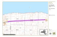
<strong>Route</strong> <strong>104</strong>. Please see Figure 1 for an illustration of the project location, and Appendix A for existing conditions<br />
photographs.<br />
1. New York State <strong>Route</strong> <strong>104</strong><br />
New York State <strong>Route</strong> <strong>104</strong> (<strong>Route</strong> <strong>104</strong>) is a 182.41-<br />
mile long east–west state highway in Upstate New York<br />
(NYSDOT, 2009). The roadway spans six counties and<br />
enters the vicinity of four cities—Niagara Falls,<br />
Lockport, Rochester, and Oswego—as it follows a route<br />
that roughly parallels the southern shoreline of Lake<br />
Ontario, along a ridge of the old shoreline of Glacial<br />
Lake Iroquois (Wikipedia, 2011; Tesmer, 1981). The<br />
western terminus of <strong>Route</strong> <strong>104</strong> is at an intersection with<br />
NYS <strong>Route</strong> 384 in Niagara Falls, Niagara County, while<br />
its eastern terminus is at a junction with NYS <strong>Route</strong> 13<br />
in the town of Williamstown, Oswego County. The<br />
portion of <strong>Route</strong> <strong>104</strong> between Rochester and the<br />
Village of Webster east of the city is a limited-access<br />
highway, and from Webster to Oswego, <strong>Route</strong> <strong>104</strong> is a<br />
super two highway (Ibid).<br />
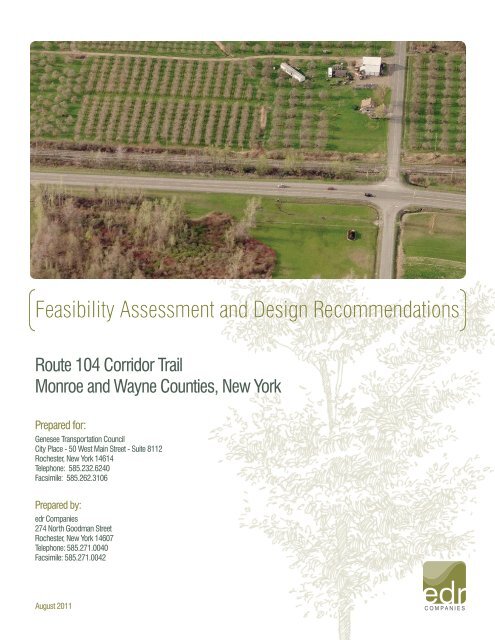
<strong>Route</strong> <strong>104</strong> and County Line Road Intersection, Webster & Ontario<br />
Photo Credit: Microsoft Virtual Earth/Pictometry<br />
In the Town of Webster, the expressway loosely parallels the southern edge of the Xerox campus to an exit with Salt<br />
Road, where it downgrades to a divided highway as it continues east to Basket Road and the Monroe–Wayne County<br />
line, partially delimited by NYS <strong>Route</strong> 404. In this area, Ridge Road and <strong>Route</strong> <strong>104</strong> split, and Ridge becomes a<br />
separate roadway just to the south. <strong>Route</strong> <strong>104</strong> continues east through Ontario, where it meets the northern terminus<br />
of NYS <strong>Route</strong> 350 in Ontario Center.<br />
Prepared for GTC and the Towns of Ontario, Sodus, Webster, and Williamson, NY Page 10
INTRODUCTION<br />
3<br />
<strong>Route</strong> <strong>104</strong> <strong>Corridor</strong> <strong>Trail</strong> <strong>Feasibility</strong> <strong>Study</strong><br />
The four-lane divided highway continues east to Williamson, where the median separating the two directions of <strong>Route</strong><br />
<strong>104</strong> comes to an end west of the hamlet of Williamson. In the center of the hamlet, <strong>Route</strong> <strong>104</strong> intersects the northern<br />
terminus of NYS <strong>Route</strong> 21. <strong>Route</strong> <strong>104</strong> narrows to two lanes east of Williamson as development along the route<br />
declines once more, giving way to open fields and thick forests. Near the center of Wayne County in the Town of<br />
Sodus, <strong>Route</strong> <strong>104</strong> serves as the northern terminus of NYS <strong>Route</strong> 88 northwest of the Village of Sodus. While NYS<br />
<strong>Route</strong> 88 heads east into the village, <strong>Route</strong> <strong>104</strong> bypasses Sodus to the north (Ibid).<br />
2. Purpose of <strong>Study</strong><br />
The study area for the <strong>Route</strong> <strong>104</strong> <strong>Corridor</strong> <strong>Trail</strong> begins at the eastern end of the existing <strong>Route</strong> <strong>104</strong> <strong>Trail</strong> in the Town<br />
of Webster and extends east through the Town of Ontario, the Town of Williamson, and part of the Town of Sodus,<br />
ending at the western boundary of the Village of Sodus.<br />
The project was guided by the following objectives:<br />
7. Provide active transportation between community resources<br />
8. Provide universal access<br />
9. Maintain user safety<br />
10. Offer a high-quality user experience<br />
11. Protect and enhance existing resources<br />
12. Emphasize sustainability & maintainability<br />
B. COMMUNITY INVOLVEMENT<br />
Planning of any kind cannot be done in a vacuum, and must be informed by local residents. GTC regularly identifies<br />
community participation as an objective in the Long Range <strong>Transportation</strong> Plan for the <strong>Genesee</strong>-Finger Lakes<br />
Region, which guides their planning efforts. The Plan states, ―The transportation planning process should be<br />
conducted in as open and visible a manner as possible, encouraging community participation and interaction<br />
between and among citizens, professional staff, and elected officials.‖<br />
Table 3.1 Chronology of Community Involvement<br />
Date What Purpose<br />
July 19, 2010 Committee Meeting Project Kick-off<br />
November 8, 2010 Committee Meeting Presentation of Inventory and Analysis<br />
December 1, 2010<br />
Public Information Meeting<br />
Project Introduction, Presentation of Inventory and Analysis,<br />
Solicit Input from Community Members<br />
January 7, 2011 Stakeholder Meeting Meeting and Tour with Ontario-Midland Railroad Management<br />
March 14, 2011 Committee Meeting Presentation of Alternatives<br />
April 6, 2011 Stakeholder Meeting Meeting and <strong>Trail</strong> Visit with Town of Ontario Officials<br />
March and April 2011 Correspondence Emails and phone calls with Rochester Gas and Electric (RG&E)<br />
June 20, 2011 Committee Meeting Presentation and Discussion of Final Recommendations<br />
July 14, 2011 Public Information Meeting Presentation of Final Recommendations, Solicit Input<br />
Prepared for GTC and the Towns of Ontario, Sodus, Webster, and Williamson, NY Page 11
INTRODUCTION<br />
3<br />
<strong>Route</strong> <strong>104</strong> <strong>Corridor</strong> <strong>Trail</strong> <strong>Feasibility</strong> <strong>Study</strong><br />
The planning process for this study included outreach to both the general public and to key stakeholders.<br />
Representatives from all affected municipalities and from interested trail organizations served on the advisory<br />
committee. The general public was invited to two public information meetings, and meetings were held with<br />
stakeholders who may be affected by the proposed trail. Appendix B includes information related to public outreach.<br />
C. RELATIONSHIP TO OTHER PLANS AND STUDIES<br />
The goal of planning is to improve the welfare of people and their communities by creating more convenient,<br />
equitable, healthful, efficient, and attractive places for present and future generations (APA, 2011). Planning enables<br />
civic leaders, businesses, and citizens to play a meaningful role in creating communities that enrich people's lives<br />
(Ibid). In developing new plans, it is important to refer to plans and studies that have already been completed to<br />
evaluate how the new plan relates to existing plans. The <strong>Route</strong> <strong>104</strong> <strong>Corridor</strong> <strong>Trail</strong> <strong>Feasibility</strong> <strong>Study</strong> builds on the<br />
following previously completed planning initiatives in Monroe and Wayne Counties:<br />
Comprehensive Plan for the Town of Williamson, NY, 2010<br />
Town of Webster, NY Comprehensive Plan Update, 2008<br />
Town of Williamson, NY: <strong>Route</strong>s 21 and <strong>104</strong> Gateway <strong>Study</strong>, 2008<br />
Design Guidelines for the Historic Business Center in the Hamlet of Williamson, NY, 2007<br />
Town of Ontario, NY Comprehensive Plan, 2006<br />
A Community Based Vision Plan for the Hamlet of Williamson, NY, 2005<br />
Regional <strong>Trail</strong>s Final Report and Action Plan: Phase Two – Non-TMA Region, 2004<br />
Wayne County Comprehensive Plan Public Opinion Survey, 2004<br />
Wayne County Recreationways Master Plan, 2001<br />
Town of Williamson Parks and Recreation Master Plan, 1999<br />
Each of these plans and studies is summarized in Appendix I, and any relevance to the proposed <strong>Route</strong> <strong>104</strong> <strong>Corridor</strong><br />
<strong>Trail</strong> study is described.<br />
D. ALTERNATIVE TRANSPORTATION BENEFITS<br />
<strong>Transportation</strong> accounts for more than thirty percent of<br />
U.S. carbon dioxide emissions (West, 2007). Alternative<br />
transportation, such as walking, bicycling, and taking<br />
public transportation, can help alleviate this problem.<br />
According to the American Public <strong>Transportation</strong><br />
Association (APTA), public transportation in the United<br />
States saves approximately 1.4 billion gallons of gasoline<br />
and about 1.5 million tons of carbon dioxide annually<br />
(APTA, 2007). Walking and bicycling as a means of<br />
transportation reduces carbon dioxide emissions even<br />
further. Walking, bicycling and public transportation<br />
benefit the environment as well as personal health,<br />
finances, time, and stress. (See Appendix C for more<br />
details on alternative transportation benefits.)<br />
Prepared for GTC and the Towns of Ontario, Sodus, Webster, and Williamson, NY Page 12
INTRODUCTION<br />
3<br />
<strong>Route</strong> <strong>104</strong> <strong>Corridor</strong> <strong>Trail</strong> <strong>Feasibility</strong> <strong>Study</strong><br />
E. TRAIL USER OVERVIEW<br />
The <strong>Route</strong> <strong>104</strong> <strong>Corridor</strong> <strong>Trail</strong> will be used by bicyclists and pedestrians of all ages and skill levels. Emerging user<br />
groups, such as strollers, bicycle trailers, wheelchairs and adult tricycles, should also be considered as a possible<br />
trail user audience. In addition, the trail is likely to be used for winter activities, such as snowmobiling, snowshoeing,<br />
and cross-country skiing. Equestrians have also been considered as possible trail users. Certain sections of the trail,<br />
located away from <strong>Route</strong> <strong>104</strong>, may be appropriate for equestrian use. The trail management entity will need to set<br />
policy regarding equestrian use in the future. Please see ―Planning for <strong>Trail</strong> Users‖ in Chapter 5: Alternatives for<br />
more detailed information about trail user groups.<br />
The feasibility study has been conducted with bicyclists and pedestrians considered to be the primary user groups. In<br />
general, bicycling is a growing mode of transportation for recreation and commuting. However, it is not currently a<br />
common way to travel to work in the study area. The 2000 and 2010 U.S. Census recorded the following data:<br />
Table 3.2. Demographic Information<br />
Town of<br />
Webster<br />
Town of<br />
Ontario<br />
Town of<br />
Williamson<br />
Town of<br />
Sodus<br />
Total Number of Residents (2010) 42,641 10,136 6,984 8,384<br />
Total Number of Residents (2000) 37,926 9,778 6,777 8,949<br />
Population Change (2000-2010) + 12.4% + 3.7% + 3.1% - 6.3%<br />
Workers* Who Biked to Work 0 0 6 (0.2%) 0<br />
Workers* Who Walked to Work 156 (0.8%) 71 (1.4%) 115 (3.6%) 91 (2.2%)<br />
Workers* Who Work Within 20 Minutes Of Home 8,562 (46%) 2,048 (42%) 1,230 (40%) 1,622 (40%)<br />
Residents Who Attend High School 2,361 600 509 517<br />
* indicates workers who are over 16 years of age<br />
In 2000, there were essentially no residents in the study area who biked to work. Approximately 1.4% of workers<br />
(over 16) in the study area walked to work. At least 40% of all workers (over 16) in the study area work within twenty<br />
minutes from home. These figures suggest an opportunity to increase walking and bicycle ridership to work with the<br />
proper facilities.<br />
In addition, students are potential walkers and bicycle users. According to the 2000 U.S. Census, 3,987 residents of<br />
the towns in the study area attended high school. Elementary and middle school students can also walk and bike to<br />
school, but may require supervision.<br />
At the time of this study, the 2010 Census data was being released by the U.S. Census Bureau. Not all of the data<br />
had been released when the study was completed, but total population for each town was available. With this data, it<br />
is possible to assess the latest population trends within the study area. With the exception of the Town of Sodus, the<br />
number of potential trail users has increased in each of the communities where the proposed trail would be located.<br />
At the western end of the trail corridor, the Town of Webster grew by 12.4%. The Towns of Ontario and Williamson<br />
grew more modestly, at 3.7% and 3.1%, respectively. At the eastern end of the trail, the Town of Sodus lost 6.3% of<br />
their population.<br />
Prepared for GTC and the Towns of Ontario, Sodus, Webster, and Williamson, NY Page 13
INVENTORY AND ANALYSIS<br />
4<br />
<strong>Route</strong> <strong>104</strong> <strong>Corridor</strong> <strong>Trail</strong> <strong>Feasibility</strong> <strong>Study</strong><br />
This section contains an inventory and analysis of existing conditions in the <strong>Route</strong> <strong>104</strong> <strong>Trail</strong> <strong>Corridor</strong>. The topics<br />
discussed in this section include the physical and environmental conditions of the study area, property ownership,<br />
circulation and transportation, and an assessment of key issues.<br />
A. PHYSICAL AND ENVIRONMENTAL CONDITIONS OF THE STUDY AREA<br />
This section describes the existing environmental conditions within the study area and in some instances, the<br />
surrounding area. Information is presented on topography, soils, ecological character, drainage and water-related<br />
issues and land use.<br />
1. General Overview of Topography<br />
The study area includes approximately 4,910 acres of land. Information regarding topography and soils was<br />
obtained from aerial surveys, on-site observations and existing published sources. Sources of information<br />
referenced include the Wayne County Soil Survey (U.S. Department of Agriculture [USDA], 1978) and the Monroe<br />
County Soil Survey (USDA, 1973), U.S. Geological Survey (USGS) topographic mapping, current and historical aerial<br />
photography, statewide bedrock geology mapping (NYS Museum/NYS Geological Survey, 1999a), and New York<br />
State surficial geology mapping (NYS Museum/NYS Geological Survey, 1999b).<br />
The study area is located in the Erie Ontario Lowlands physiographic province of Wayne County and the Erie-Ontario<br />
Lake Plain region of Monroe County (USDA, 1978 & 1973). The topography of this physiographic area ranges from<br />
nearly level to gently sloping lake plain. The study area is located within the clay plains portion of this lowland area,<br />
characterized by nearly level, prairie-like areas of clayey soils (USDA, 1989). The topography in the study area is<br />
relatively flat with a gentle slope toward the north in the direction of Lake Ontario. Further south of the study area,<br />
the landscape becomes more undulated with numerous hilltops, which are in close proximity at the southeastern<br />
edge of the study area. Slopes range from 0 to 15 percent but are predominantly 0 to 3 percent. Elevations range<br />
from approximately 390 feet above mean sea level (amsl) between East Williamson and Sodus along the northern<br />
boundary of the study area to approximately 590 feet amsl in the southeast corner of the study area near Sodus.<br />
Generally the elevation along the corridor is approximately 410-430 feet amsl. See Figure 2 for more information.<br />
Relatively flat topography provides gentle, easy terrain for all trail users. This will be desirable for any bicyclists<br />
wishing to use the route for commuting. In addition, the terrain will easily allow for an ADA-accessible trail. The<br />
terrain will not offer elevated viewpoints, but will still have scenic views when there are variations and openings in the<br />
vegetation.<br />
2. Soils<br />
The Soil Surveys of Wayne and Monroe Counties, New York (USDA, 1978 & 1973) have mapped general soil<br />
associations and soil types within the study area (see Tables 4.1 and 4.2). The soil surveys indicate that 16 soil<br />
associations, and 84 soil map units, are present within the study area. The dominant soil map units within the study<br />
area (as defined by coverage of greater than 250 acres) are Lockport and Brockport silty clay loams 0-3 percent<br />
slopes, Minoa very fine sandy loam, Appleton loam 0-5 percent slopes, and Hilton gravelly loam bedrock substratum<br />
0-3 percent slopes.<br />
Soils in the study area are variable, with drainage ranging from excessively drained to very poorly drained, depths<br />
generally deep, and parent materials including glacial lake deposits and glacial till. Soil textures in the study area are<br />
primarily silty loam and sandy loam. Table 4.1 lists the soil associations found within the study area and their<br />
characteristics. Table 4.2 summarizes the characteristics of the four dominant soil map units found in the study area.<br />
Prepared for GTC and the Towns of Ontario, Sodus, Webster, and Williamson, NY Page 14
INVENTORY AND ANALYSIS<br />
4<br />
<strong>Route</strong> <strong>104</strong> <strong>Corridor</strong> <strong>Trail</strong> <strong>Feasibility</strong> <strong>Study</strong><br />
Table 4.1. Soil Associations Within the <strong>Study</strong> Area 1<br />
Appleton-Lockport 2<br />
Madrid-Bombay<br />
Ira-Sodus<br />
Madrid-Massena<br />
Ontario-Hilton<br />
Soil Association<br />
Lockport-Cazenovia-Lairdsville<br />
Lima-Honeoye-Ontario<br />
Riga-Brockport<br />
Benson-Honeoye<br />
Sodus-Ira-Niagara<br />
<br />
<br />
<br />
<br />
<br />
<br />
<br />
<br />
<br />
<br />
<br />
<br />
<br />
<br />
<br />
<br />
<br />
<br />
<br />
<br />
<br />
<br />
<br />
<br />
<br />
<br />
<br />
<br />
<br />
<br />
<br />
<br />
<br />
<br />
<br />
<br />
<br />
<br />
Main Characteristics<br />
Somewhat poorly drained<br />
Deep and moderately deep soils<br />
Medium textures and moderately fine textured soils<br />
On glacial till plains<br />
Formed in glacial till deposits<br />
Well drained and moderately well drained<br />
Deep soils<br />
Moderately coarse textured soils<br />
On glacial till plains<br />
Formed in glacial till deposits<br />
Moderately well drained and well drained<br />
Deep Soils<br />
Moderately coarse textured soils that have fragipan<br />
On glacial till plains<br />
Formed in glacial till deposits<br />
Well drained to poorly drained<br />
Deep soils<br />
Moderately coarse textured to medium textured<br />
On undulating morainic areas of the till plain<br />
Well drained to moderately well drained<br />
Deep soils<br />
Medium-textured to moderately fine textured<br />
On dissected till plains where drumlins are a prominent feature<br />
of the landscape<br />
Somewhat poorly drained to well drained<br />
Deep to moderately deep soils<br />
Moderately fine textured to fine textured<br />
Well drained to moderately well drained<br />
3 ½ - 6 feet deep<br />
Medium textured to moderately fine textured<br />
Well drained to somewhat poorly drained<br />
Moderately deep<br />
Moderately fine textured to fine textured<br />
Excessively drained to well drained<br />
Shallow to deep soils<br />
Medium textured<br />
Well drained to moderately well drained<br />
Deep soils<br />
Moderately coarse textured to medium textured<br />
1<br />
Information gathered from the Soil Surveys of Wayne and Monroe Counties, New York (USDA, 1978 & 1973).<br />
2<br />
This soil association covers the vast majority of the <strong>Study</strong> Area.<br />
Prepared for GTC and the Towns of Ontario, Sodus, Webster, and Williamson, NY Page 15
INVENTORY AND ANALYSIS<br />
4<br />
<strong>Route</strong> <strong>104</strong> <strong>Corridor</strong> <strong>Trail</strong> <strong>Feasibility</strong> <strong>Study</strong><br />
Table 4.2. Dominant Soil Map Units Within the <strong>Study</strong> Area 1<br />
Soil Map Unit<br />
Main Characteristics<br />
Somewhat poorly drained<br />
Lockport and Brockport silty clay loams 0-3 percent Overlies shale bedrock<br />
slopes (LoA)<br />
Depth to bedrock is 20 to 40 inches<br />
On moderately low areas on bedrock-controlled landscapes<br />
Somewhat poorly drained<br />
Minoa very fine sandy loam (Mn)<br />
Depth to bedrock is >60 inches<br />
On lake plains and deltas<br />
Somewhat poorly drained<br />
Appleton loam 0-5 percent slopes (Ap)<br />
Depth to bedrock is >60 inches<br />
On footslopes and in moderately low areas on till plains<br />
Moderately well drained<br />
Hilton gravelly loam bedrock substratum 0-3 percent Overlies sandstone and limestone bedrock<br />
slopes (HoA)<br />
Depth to bedrock is 40 to 60 inches<br />
In slightly convex areas on till plains<br />
1<br />
Information gathered from the Soil Surveys of Wayne and Monroe Counties, New York (USDA, 1978 & 1973).<br />
The study area consists of numerous pockets of prime<br />
farmland soils as listed by the USDA, totaling 1,833 acres.<br />
Elnora loamy fine sand (map units ElA and ElB) and Hilton<br />
gravelly loam (map units HoA and HoB) are the most<br />
common prime farmland soils within the study area.<br />
The Soil Surveys have classified the erosion hazard for each<br />
soil type as slight, moderate, or severe, and all of the soils<br />
within the study area have a slight erosion hazard. Soil<br />
drainage characteristics are variable, as previously<br />
mentioned, with approximately 19 percent of the study area<br />
well drained to excessively drained, 18 percent moderately<br />
well drained, and 56 percent somewhat poorly drained to<br />
very poorly drained (USDA, 1973 & 1978).<br />
For trail planning purposes, the soils are fundamentally<br />
suitable for trail use. The soils in the study area should not<br />
present an erosion problem, but may have some drainage<br />
issues.<br />
Mink Creek, Looking North From <strong>Route</strong> <strong>104</strong>, Williamson<br />
Prepared for GTC and the Towns of Ontario, Sodus, Webster, and Williamson, NY Page 16
INVENTORY AND ANALYSIS<br />
4<br />
<strong>Route</strong> <strong>104</strong> <strong>Corridor</strong> <strong>Trail</strong> <strong>Feasibility</strong> <strong>Study</strong><br />
3. Ecological Character<br />
On November 2, 2010, an edr ecologist visited the study area to specifically identify the dominant ecological<br />
communities, wildlife habitat and streams present within the study area. The following discussion summarizes the<br />
field inventory of existing cover types and habitat assessment. An examination of rare, threatened and endangered<br />
species, as well as a summary of invasive species is provided.<br />
Inventory of Existing Cover Types. The study area is set amongst a significant regional transportation corridor.<br />
Please refer to Appendix J for more detail, but general community cover types include:<br />
<br />
<br />
<br />
<br />
<br />
<br />
<br />
<br />
<br />
Northern Deciduous Forest<br />
Riparian Forest and Forested Wetland<br />
Mixed Conifer and Northern Hardwood Forest<br />
Successional Old-Field<br />
Emergent Wetland<br />
Successional Shrubland<br />
Scrub Shrub Wetland<br />
Agricultural Land<br />
Developed/Disturbed Land<br />
Rare Threatened and Endangered Species. A letter dated February 9, 2011 was sent by edr to the New York<br />
Natural Heritage Program. A response dated February 23, 2011, identified one State-protected fish species<br />
(historical record), in the study area. The Natural Heritage Report on Rare Species and Ecological Communities<br />
identified the Blackchin Shiner (Notropis heterodon), as having been seen in Salmon Creek in the Town of<br />
Williamson. This species has been ranked by the New York Natural Heritage Program as S1, meaning typically 5 or<br />
fewer occurrences. In addition, the New York Natural Heritage Program identifies this species as ―critically impaired‖.<br />
The Federally Listed Endangered and Threatened Species and Candidates Species list identifies the following plant<br />
and wildlife species on a countywide level for Wayne County: bald eagle (Haliaeetus leucocephalus), bog turtle<br />
(Clemmys muhlenbergii), Eastern prairie fringed orchid (historic) (Platanthera leucophea), and Indiana bat (Myotis<br />
sodalis). No federally listed plant or wildlife species are identified for the part of the study area located in Monroe<br />
County. Although more rigorous study is required to definitively conclude the presence or absence of these rare,<br />
threatened and endangered species, there were no observations of these species made during the site visit.<br />
Invasive species. Invasive plant species are problematic in certain areas of the study area. Several invasive<br />
species such as common reed, honeysuckle, buckthorn, multiflora rose and privet are beginning to concentrate<br />
heavily in several upland and wetland areas in the study area. Common reed was the most prevalent invasive<br />
species observed in roadside ditches and in several of the wetlands and streams.<br />
Habitat Assessment. The study area includes a variety of ecological community types. Wildlife observations<br />
throughout the study area during the site visit included Canada goose, mallard, great blue heron, whitetail deer<br />
including numerous tracks and trails, mink, American crow, red tailed hawk, various songbirds, and green frogs.<br />
Please refer to Appendix J for more detail, but the following habitat types can be seen in the study area: Mature<br />
Forest Habitat, Successional Forest Habitat, Wetland Habitat, and Successional Old Field Habitat. For trail planning,<br />
the variety of habitats and ecological cover types will provide opportunities for environmental education. The trail<br />
alignment should maximize scenic resources and opportunities to put trail users in contact with nature.<br />
Prepared for GTC and the Towns of Ontario, Sodus, Webster, and Williamson, NY Page 17
INVENTORY AND ANALYSIS<br />
4<br />
<strong>Route</strong> <strong>104</strong> <strong>Corridor</strong> <strong>Trail</strong> <strong>Feasibility</strong> <strong>Study</strong><br />
4. Drainage and Water-Related Issues<br />
Federal and State Wetlands. There are federal and state designated wetlands within the study area based on<br />
preliminary review of both United States Fish and Wildlife Service (FWS) National Wetlands Inventory (NWI) mapping<br />
and the NYSDEC freshwater wetlands mapping database.<br />
Waters of the United States. Waters of the United States as defined by the United States Army Corps of Engineers<br />
(Corps), include all lakes, ponds, streams (intermittent and perennial), and wetlands. Wetlands are defined in<br />
Section 404 of the Clean Water Act as ―those areas that are inundated or saturated by surface or groundwater at a<br />
frequency and duration sufficient to support and under normal circumstances do support a prevalence of vegetation<br />
typically adapted for life in saturated soil conditions‖ (EPA, 2001). Jurisdictional wetlands are defined by the<br />
presence of three criteria: hydrophytic vegetation, hydric soils, and evidence of wetland hydrology during the growing<br />
season (Environmental Laboratory, 1987). However, it has been determined that the Corps does not have<br />
jurisdictional authority over waters that are ―non-navigable, isolated, and intrastate‖ (EPA, 2001). Ultimately, the<br />
status of all delineated waters will be determined during a field visit with a Buffalo District Corps representative.<br />
Review of NWI mapping indicates that there are 95 federally-mapped wetlands located within and adjacent to the<br />
study area. The federally mapped wetlands are identified in Figure 3. While many of these wetlands occur along<br />
streams and rivers, a number of them occur in depressional areas scattered throughout the study area.<br />
New York State Freshwater Wetlands & Protected Streams. The Freshwater Wetlands Act (Article 24 and Title 23 of<br />
Article 71 of the Environmental Conservation Law) gives the NYSDEC jurisdiction over state-protected wetlands and<br />
adjacent areas (100-foot upland buffer). The Freshwater Wetlands Act requires the NYSDEC to map all stateprotected<br />
wetlands (typically over 12.4 acres in size) to allow landowners and other interested parties a means to<br />
determine where state jurisdictional wetlands exist. Review of NYSDEC mapping indicates that there are 16<br />
wetlands located within the vicinity of the study area that are regulated under Article 24 of the Environmental<br />
Conservation Law. The state-regulated wetlands are identified in Figure 3.<br />
Under Article 15 of the Environmental Conservation Law (Protection of Waters), the NYSDEC has regulatory<br />
jurisdiction over any activity that disturbs the bed or banks of protected streams. In addition, small lakes and ponds<br />
with a surface area of 10 acres or less, located within the course of a stream, are considered to be part of a stream<br />
and are subject to regulation under the stream protection category of Article 15. Protected stream means any<br />
stream, or particular portion of a stream, that has been assigned by the NYSDEC any of the following classifications<br />
or standards: AA, AA(t), A, A(t), B, B(t) or C(t) (6 NYCRR Part 701). A classification of AA or A indicates that the best<br />
use of the stream is as a source of water supply for drinking, culinary or food processing purposes; primary and<br />
secondary contact recreation; and fishing. The best usages of Class B waters are primary and secondary contact<br />
recreation and fishing. The best usage of Class C waters is fishing. Streams designated (t) indicate that they<br />
support trout, and also include those more specifically designated (ts) which support trout spawning. Classification D<br />
is unprotected waters and suitable for fishing and non-contact recreation.<br />
These streams, along with all other perennial and intermittent streams in the study area, are also protected by the<br />
Corps under Section 404 of the Clean Water Act. No stream occurs within the study area that is regulated by Section<br />
10 of the Rivers and Harbors Act of 1899 (navigable waters). All study area streams are classified by the NYSDEC<br />
as Class C waters, indicating that they are suitable for non-contact activities and supporting fisheries. Class C<br />
waters are not subject to regulation under the stream protection category of the Environmental Conservation Law,<br />
Article 15 (Protection of Waters) (See Figure 3).<br />
Prepared for GTC and the Towns of Ontario, Sodus, Webster, and Williamson, NY Page 18
INVENTORY AND ANALYSIS<br />
4<br />
<strong>Route</strong> <strong>104</strong> <strong>Corridor</strong> <strong>Trail</strong> <strong>Feasibility</strong> <strong>Study</strong><br />
A formal wetland delineation is needed to make a final determination of wetland and stream boundaries. The<br />
wetland delineation would need to be conducted according to the three-parameter methodology presented in the<br />
1987 Corps of Engineers Wetland Delineation Manual (Environmental Laboratory, 1987) and the updated<br />
methodologies presented in the Interim Regional Supplement to the Corps of Engineers Wetland Delineation Manual:<br />
Northcentral and Northeast Region (2009). A final determination of jurisdictional status can only be made after an<br />
on-site agency review of identified boundaries.<br />
Stream Assessment. A preliminary stream assessment was conducted on November 2, 2010, by an edr ecologist.<br />
Stream characteristics such as morphology, gradient, channel bottom substrate, flow, instream conditions, and<br />
adjacent community type were recorded along reaches of the 14 main streams crossing the study area. For the<br />
purposes of reporting data and observations, Table 4.3 below provides a summary of the stream characteristics<br />
recorded at each reach.<br />
Table 4.3. Stream Characteristics<br />
Stream<br />
Name<br />
Fourmile<br />
Creek W<br />
DEC<br />
Stream<br />
Class<br />
C<br />
Channel Morphology<br />
Bank Width: 10-15 ft.<br />
Stream Width: 6-8 ft.<br />
Water Depth 2 in.-6 in.<br />
Gradient<br />
Gentle<br />
Channel<br />
Substrate<br />
Cobble and<br />
Stone<br />
Flow<br />
Moderate<br />
Instream<br />
Conditions<br />
Perennial stream<br />
with cobble/stone<br />
substrate. Good<br />
riffle/run sequence<br />
with minimal bank<br />
erosion and<br />
overhanging<br />
vegetation.<br />
Adjacent<br />
Community<br />
Type<br />
Narrow riparian<br />
corridor<br />
(locust/maple) with<br />
adjacent residential<br />
areas and mowed<br />
lawns.<br />
Fourmile<br />
Creek E<br />
C<br />
Bank Width:<br />
Stream Width:<br />
Water Depth<br />
5-8 ft.<br />
3-4 ft.<br />
2 in.-4 ft.<br />
Gentle<br />
Silt, stone and<br />
Cobble<br />
Gentle<br />
Perennial stream<br />
with obscured<br />
vegetated banks<br />
and no sign of<br />
erosion.<br />
Developed land on<br />
either side of stream<br />
in study area.<br />
Riparian forest<br />
buffers some of the<br />
adjacent<br />
development SW of<br />
study area.<br />
Unnamed<br />
Stream 1<br />
C<br />
Bank Width:<br />
Stream Width:<br />
Water Depth<br />
6 ft.<br />
3 ft.<br />
2 in.-6 ft.<br />
Gentle Silt and Sand Gentle<br />
Intermittent stream<br />
with obscured<br />
vegetated banks.<br />
No sign of erosion.<br />
Invasives present<br />
(reed).<br />
Old-field/scrub shrub<br />
community with<br />
developed land<br />
adjacent.<br />
Unnamed<br />
Stream 2<br />
C<br />
Bank Width:<br />
Stream Width:<br />
Water Depth<br />
4-5 ft.<br />
3-4 ft.<br />
4-6 in.<br />
Gentle<br />
Silt, sand and<br />
vegetated<br />
substrate.<br />
Gentle<br />
Straightened<br />
intermittent<br />
channel with<br />
obscured<br />
vegetated banks.<br />
Mowed lawn/<br />
developed land.<br />
Mill Creek<br />
C<br />
Bank Width:<br />
Stream Width:<br />
Water Depth<br />
30-40 ft.<br />
10-15 ft.<br />
2 in – 1 ft.<br />
Gentle<br />
Silt, sand and<br />
cobble.<br />
Gentle<br />
Perennial stream.<br />
Vegetated banks<br />
with minimal signs<br />
of erosion.<br />
Riparian forest<br />
including maple,<br />
locust, and willow.<br />
Dennison<br />
Creek W.<br />
C<br />
Bank Width:<br />
Stream Width:<br />
2 ft.<br />
1 ft.<br />
Gentle<br />
Silt, sand and<br />
vegetated<br />
substrate.<br />
Gentle<br />
Intermittent stream<br />
with obscured<br />
vegetated banks<br />
and no sign of<br />
erosion. Common<br />
Mowed lawn and<br />
developed land.<br />
(Electrical<br />
substation)<br />
Prepared for GTC and the Towns of Ontario, Sodus, Webster, and Williamson, NY Page 19
INVENTORY AND ANALYSIS<br />
4<br />
<strong>Route</strong> <strong>104</strong> <strong>Corridor</strong> <strong>Trail</strong> <strong>Feasibility</strong> <strong>Study</strong><br />
Water Depth<br />
2-4 in.<br />
reed present on<br />
north side.<br />
Dennison<br />
Creek E.<br />
C<br />
Bank Width:<br />
Stream Width:<br />
Water Depth<br />
6-8 ft.<br />
2-4 ft.<br />
4-6 in.<br />
Gentle<br />
Silt, sand and<br />
vegetated<br />
channel.<br />
Gentle<br />
Heavily vegetated<br />
intermittent stream<br />
(common reed and<br />
cattail).<br />
Developed land<br />
(parking lots)<br />
Unnamed<br />
Stream 3<br />
C<br />
Bank Width:<br />
Stream Width:<br />
Water Depth<br />
6-8 ft.<br />
2-4 ft.<br />
2-6 in.<br />
Gentle<br />
Silt, sand and<br />
vegetated<br />
substrate.<br />
Gentle<br />
Heavily vegetated<br />
intermittent stream<br />
(goldenrod and<br />
cattail).<br />
Straightened<br />
channel geometry.<br />
Developed land<br />
(mowed land and<br />
parking lots)<br />
Bear<br />
Creek W.<br />
C<br />
Bank Width:<br />
Stream Width:<br />
Water Depth<br />
10-15 ft.<br />
4-6 ft.<br />
4 in.–1 ft.<br />
Gentle Silt and sand. Moderate<br />
Perennial stream<br />
with almost<br />
completely<br />
vegetated and<br />
minimal erosion.<br />
Stream geometry<br />
altered due to<br />
adjacent<br />
development.<br />
Narrow vegetative<br />
corridor (dogwood,<br />
spirea, reed, cattail<br />
and goldenrod) in<br />
developed<br />
landscape (plazas).<br />
Bear<br />
Creek E.<br />
C<br />
Bank Width:<br />
Stream Width:<br />
Water Depth<br />
10-15 ft.<br />
4-6 ft.<br />
4 in. – 1 ft.<br />
Gentle<br />
Silt, stone and<br />
Cobble<br />
Moderate<br />
Perennial stream<br />
with good riffle/run<br />
sequence and<br />
minimal bank<br />
erosion.<br />
Overhanging<br />
vegetation.<br />
Expansive riparian<br />
corridor (maple, ash<br />
and locust).<br />
Unnamed<br />
Stream 4<br />
C<br />
Bank Width:<br />
Stream Width:<br />
Water Depth<br />
4-6 ft.<br />
2-4 ft.<br />
2–4 in.<br />
Gentle<br />
Silt, sand and<br />
vegetated<br />
substrate.<br />
Gentle<br />
Vegetated<br />
intermittent stream<br />
with obscure<br />
banks and no<br />
erosion.<br />
Expansive riparian<br />
corridor (maple, ash<br />
and locust).<br />
Salmon<br />
Creek<br />
C<br />
Bank Width:<br />
Stream Width:<br />
Water Depth<br />
25 ft.<br />
15-20 ft.<br />
4-6 in.<br />
Gentle<br />
Silt, stone,<br />
cobble and<br />
vegetated<br />
substrate.<br />
Gentle<br />
Perennial stream<br />
with almost<br />
completely<br />
vegetated and<br />
minimal erosion.<br />
Stream geometry<br />
altered due to<br />
adjacent<br />
development.<br />
Partial riparian<br />
corridor amongst<br />
developed<br />
landscape.<br />
Unnamed<br />
Stream 5<br />
C<br />
Bank Width:<br />
Stream Width:<br />
Water Depth<br />
10-12 ft.<br />
4-6 ft.<br />
4-6 in.<br />
Gentle<br />
Silt, sand and<br />
vegetated<br />
substrate.<br />
Gentle<br />
Vegetated<br />
intermittent stream<br />
(iris, cattail,<br />
jewelweed, rush<br />
and mint).<br />
Straightened<br />
channel geometry.<br />
Developed land<br />
(mowed land and<br />
parking lots)<br />
Mink<br />
Creek<br />
C<br />
Bank Width:<br />
Stream Width:<br />
Water Depth<br />
10 ft.<br />
4-6 ft.<br />
4-6 in.<br />
Gentle<br />
Silt, stone and<br />
cobble.<br />
Moderate<br />
Heavily vegetated<br />
perennial stream<br />
(cattail). Expansive<br />
riparian corridor<br />
downstream.<br />
Partial riparian and<br />
emergent wetland<br />
corridor amongst<br />
developed<br />
landscape.<br />
Prepared for GTC and the Towns of Ontario, Sodus, Webster, and Williamson, NY Page 20
INVENTORY AND ANALYSIS<br />
4<br />
<strong>Route</strong> <strong>104</strong> <strong>Corridor</strong> <strong>Trail</strong> <strong>Feasibility</strong> <strong>Study</strong><br />
General Characteristics of <strong>Study</strong> Area Streams. A<br />
stable stream can be generally defined as a stream that<br />
transports sediment load while maintaining stream<br />
geometry and does not aggrade or degrade (Rosgen,<br />
1996). Although many of the streams within the study<br />
area have been engineered due to their proximity to<br />
<strong>Route</strong> <strong>104</strong>, these streams seem to be in stable<br />
condition. Based on preliminary observations, in most<br />
cases no eroded, undercut banks were observed. A<br />
more detailed analysis is needed to accurately predict<br />
channel stability. Streams were assessed in close<br />
proximity to <strong>Route</strong> <strong>104</strong>, but typically the waterways<br />
become more scenic and naturalized further away from<br />
the highway.<br />
Salmon Creek, Looking North From <strong>Route</strong> <strong>104</strong>, Williamson<br />
As described in Table 4.3, on-site streams range in size and type from small intermittent channels (1-2ft.) to larger<br />
perennial streams (15-20 ft.). For the most part, stream banks observed were obscured and completely vegetated in<br />
a silt/sand substrate. The amount of silt/sand present does, however, indicate that increased sediment loading is<br />
taking place from some upstream erosion. Smaller intermittent streams in many cases are straightened due to<br />
adjacent development. The larger stream channels are wide and flat in a silt/sand/cobble substrate. As previously<br />
mentioned, development is present in and around many of the streams, and the riparian corridor and floodplain are<br />
greatly reduced, which decreases floodwater retention. In some instances, the larger streams are associated with<br />
floodplain forest offering good shading and cover for riparian/aquatic species. With the exception of a few small<br />
intermittent streams, sinuosity is generally more moderate in the stream reaches observed within the study area, and<br />
water depths shallower along a gentle stream gradient. In addition, streams with a larger riparian corridor have a<br />
more apparent natural riffle run sequence with increased stone/gravel bars creating riffles with long runs in several<br />
locations. For more information, please see Appendix D.<br />
Salmon Creek, Looking South Towards <strong>Route</strong> <strong>104</strong>, Williamson<br />
For trail planning, there are a number of things<br />
to consider in relationship to waterways. When<br />
planning stream crossings, there are<br />
environmental impacts and permitting issues<br />
that should be minimized as much as possible.<br />
Stream crossings typically involve a structure,<br />
such as a boardwalk or bridge, which has<br />
associated cost impacts. Stream crossings<br />
have positive aspects, too. Bridges often<br />
become a landmark or destination along a trail<br />
corridor, which can help with wayfinding in a<br />
long, linear path such as the <strong>Route</strong> <strong>104</strong> <strong>Corridor</strong><br />
<strong>Trail</strong>. Streams also offer opportunities for<br />
scenic views and environmental education.<br />
Potential flooding issues can be addressed with<br />
eco-swales, rain gardens and retention ponds.<br />
Prepared for GTC and the Towns of Ontario, Sodus, Webster, and Williamson, NY Page 21
INVENTORY AND ANALYSIS<br />
4<br />
<strong>Route</strong> <strong>104</strong> <strong>Corridor</strong> <strong>Trail</strong> <strong>Feasibility</strong> <strong>Study</strong><br />
5. Land Use<br />
A snapshot of the existing land use can be illustrated by examining character zones and destinations along the <strong>Route</strong><br />
<strong>104</strong> <strong>Corridor</strong>. In addition, Figure 5 (Sheets 1 and 2) illustrates existing land use in and around the study area.<br />
Character Zones. The study area can be broken into six character zones, based primarily on land use, ecological<br />
character, and natural boundaries. The first character zone begins at the existing <strong>Route</strong> <strong>104</strong> trailhead, and ends at<br />
Salt Road in Webster. This zone is a focal point along the corridor, where the existing trail and the new trail will<br />
connect. The second character zone begins at Salt Road and ends at the County line between Wayne and Monroe<br />
Counties. The character of this zone is primarily mixed use commercial. The third character zone begins at the<br />
County line and ends at Furnace Road in the Town of Ontario. Zone 3 is primarily rural and undeveloped with<br />
heavier development and destinations located on the south side of <strong>Route</strong> <strong>104</strong>.<br />
The fourth character zone begins at Furnace Road in Ontario and ends at Tuckahoe Road in the Town of Williamson.<br />
This zone is primarily rural and undeveloped with a few significant nodes of development. The fifth character zone<br />
begins at Tuckahoe Road and ends at Pound Road, all within the Town of Williamson. The character of Zone 5 is a<br />
mix of commercial and residential uses. The sixth character zone begins at Pound Road in Williamson and ends at<br />
State <strong>Route</strong> 88 in the Town of Sodus. The character of this zone is rural farmland and mixed commercial. See<br />
Figure 7 for a map and Appendix A for photographs of existing conditions in the character zones.<br />
Destinations. Throughout the <strong>Route</strong> <strong>104</strong> <strong>Corridor</strong> are a number of destinations. Some destinations are a point of<br />
interest that might generate visits from people who live outside the local area, while others are more common<br />
services that would be visited primarily by local residents. All of these destinations can be considered pedestrian<br />
generators, or destinations that are frequented by pedestrians. In general, they are clustered near the downtown of<br />
each municipality, but are also found scattered along <strong>Route</strong> <strong>104</strong>. They include, but are not limited to:<br />
- Retail plazas and commercial areas in Ontario, Williamson and Sodus that include grocery stores,<br />
shopping, and financial institutions;<br />
- Schools in the Ontario, Sodus and Williamson school districts;<br />
- Libraries: Ontario Public Library, Sodus Free Library, and the Williamson Free Library;<br />
- Post offices in Union Hill, Ontario Center, Ontario, Williamson, and East Williamson;<br />
- Places of worship: More than 25 were identified in and near the corridor<br />
- Public parks: Irving R. Kent Park, Casey Park, Ontario Golf Course, B. Forman County Park, Williamson<br />
Town Park, and Beechwood State Park<br />
- Wegman‘s Passport Destinations: Bicentennial Park, Casey Park, Sodus Wallington <strong>Trail</strong>, and the<br />
Williamson Town Loop <strong>Trail</strong><br />
- Major places of employment: Xerox Corporation, Mott‘s North America, Ginna Nuclear Power Plant,<br />
Williamson and Sodus Airport, and Heluva Good Cheese<br />
- Significant travel destinations (in nearby vicinity): Historic Pultneyville, Sodus Point<br />
These land uses are prime examples of pedestrian generators. It is important that residents and visitors are able to<br />
safely walk (or bike) to and between some of these corridor destinations. Figure 6 illustrates the existing destinations<br />
located along the <strong>Route</strong> <strong>104</strong> <strong>Corridor</strong>. Strong pedestrian connections between destinations are what sustain a<br />
thriving pedestrian environment. <strong>Trail</strong> planning should strive to improve access for all types of trail users, whether the<br />
trail is being used for adjacent destinations within one character zone, or to provide a connection between different<br />
zones. <strong>Trail</strong> planning should also be context sensitive, responding to the different character zones and destinations,<br />
but following current best practices and guidelines from FHWA, AASHTO, and NYSDOT.<br />
Prepared for GTC and the Towns of Ontario, Sodus, Webster, and Williamson, NY Page 22
INVENTORY AND ANALYSIS<br />
4<br />
<strong>Route</strong> <strong>104</strong> <strong>Corridor</strong> <strong>Trail</strong> <strong>Feasibility</strong> <strong>Study</strong><br />
B. PROPERTY OWNERSHIP<br />
This section reviews property ownership along the trail corridor as well as easements and rights of way within the<br />
study area.<br />
1. Adjacent Properties<br />
This section examines property ownership along the trail corridor for properties potentially affected by the proposed<br />
alignment alternatives.<br />
Immediately Adjacent to <strong>Route</strong> <strong>104</strong>. A significant number of properties are located in the area immediately<br />
adjacent to the <strong>Route</strong> <strong>104</strong> R.O.W. The following chart identifies the number of property owners on the North and<br />
South sides of <strong>Route</strong> <strong>104</strong>.<br />
Character Zone<br />
Table 4.4. Property Owners Adjacent to <strong>Route</strong> <strong>104</strong><br />
Properties on the<br />
South Side of <strong>Route</strong> <strong>104</strong><br />
Properties on the<br />
North Side of <strong>Route</strong> <strong>104</strong><br />
Zone 1 - <strong>Trail</strong>head 3 parcels 1 parcel<br />
Zone 2 – Salt to County Line Road 32 parcels 2 parcels<br />
Zone 3 – County Line to Furnace Road 96 parcels 44 parcels<br />
Zone 4 – Furnace to Tuckahoe Road 18 parcels 3 parcels<br />
Zone 5 – Tuckahoe to Pound Road 37 parcels 16 parcels<br />
Zone 6 – Pound to State <strong>Route</strong> 88 70 parcels 13 parcels<br />
Total Properties 256 parcels 79 parcels<br />
The significant number of property owners adjacent to <strong>Route</strong> <strong>104</strong> (and their associated driveways) will create some<br />
potential difficulties in negotiating access to a trail in the <strong>Route</strong> <strong>104</strong> R.O.W., as well as potential safety hazards.<br />
Town of Ontario. Over the past few years, the Town of Ontario has been developing an east-west trail across the<br />
Town. Town officials have negotiated access, used Town land, or acquired new properties to create several miles of<br />
multi-use trail. The Ontario trail extends from Dean Parkway in the west to just beyond Furnace Road in the east.<br />
Some segments are still being negotiated, but the Town has had reasonable success thus far. One highlight of this<br />
trail is the proximity to Casey Park. Town officials would like to connect the <strong>Route</strong> <strong>104</strong> <strong>Corridor</strong> <strong>Trail</strong> to this trail,<br />
rather than create a parallel trail nearby. This trail corridor is described in more detail in the following section.<br />
2. Easements and Rights of Way<br />
This section inventories easements and rights of way within the study area that could potentially be used to<br />
accommodate a multi-use trail.<br />
New York State <strong>Route</strong> <strong>104</strong>. The right of way for <strong>Route</strong> <strong>104</strong> could potentially be used to accommodate a multi-use<br />
trail, but a large number of property owners would be affected and involved. According to digital mapping, the<br />
existing R.O.W. varies between 790 feet at Salt Road in Webster and 130 feet at East Townline Road in Williamson.<br />
In general, the R.O.W. ranges between 150 and 200 feet wide. Due to this variability, certain portions of the R.O.W.<br />
are more able to accommodate a trail than other areas.<br />
Prepared for GTC and the Towns of Ontario, Sodus, Webster, and Williamson, NY Page 23
INVENTORY AND ANALYSIS<br />
4<br />
<strong>Route</strong> <strong>104</strong> <strong>Corridor</strong> <strong>Trail</strong> <strong>Feasibility</strong> <strong>Study</strong><br />
Town of Ontario Hiking <strong>Trail</strong>, Ontario<br />
Town of Ontario Easements. The Town of Ontario has used Town land and has negotiated/ is negotiating access<br />
to a number of other properties. Together, these properties will accommodate a 5.5-mile trail corridor. Portions of<br />
the trail have been constructed, others have not. The trail corridor is described here and illustrated in Figure 13.<br />
At the western end, the trail begins at Dean Parkway, approximately 800 feet north of <strong>Route</strong> <strong>104</strong>. The trail runs in an<br />
easterly direction, adjacent to Timothy Lane behind Harbec Plastics. The trail turns slightly to the north and continues<br />
in an easterly direction to Lakeside Road, crossing Mill Creek along the way. From Lakeside Road, the trail trends<br />
slightly south while continuing in an easterly direction. Just to the west of Slocum Road, the trail crosses Dennison<br />
Creek (West).<br />
At Slocum Road, the trail turns and heads in a northeasterly direction for approximately 3,750 feet (0.7 miles) in the<br />
RG&E utility corridor. In the utility corridor, the trail crosses Dennison Creek (East) and a small pond. Approximately<br />
400 feet from Kenyon Road, the trail turns due east for 350 feet, and then turns southeast/east across the old Town<br />
landfill. The trail crosses Ontario Center Road and travels due east along the long narrow pond in Casey Park to the<br />
park entrance at Knickerbocker Road. The trail continues to travel due east after crossing Knickerbocker for<br />
approximately 1,100 feet, then turns due south for about 700 feet. At this point, the trail turns to the east again and<br />
goes across Town land to Furnace Road. The trail heads south along Furnace Road for approximately 700 feet.<br />
From Furnace Road, the trail turns and heads to the east for about 2,200 feet, crossing over the West and East<br />
branches of Bear Creek.<br />
Ontario Midland Railroad. The right of way for Ontario-Midland Railroad has excellent potential to accommodate a<br />
multi-use trail. The existing R.O.W. is 100 feet and owned by Rochester Gas and Electric/Iberdrola USA. The<br />
railroad infrastructure is owned by Ontario-Midland Railroad. An expansion of the R.O.W. is planned to create a fall<br />
zone for trees, which would generate 25 feet on the North side of the existing R.O.W. Site analysis indicates that<br />
there are encroachments into the railroad R.O.W. that will need to be resolved prior to further trail development.<br />
County Road 103/ Ridge Road. The public right-of-way for Ridge Road could be used to accommodate on-street or<br />
shoulder improvements. In general, there is not enough room to create a separate multi-use trail along the entire<br />
corridor, but the R.O.W. could be used to create an on-street, active transportation corridor. Possibilities might<br />
include bicycle lanes, a shared roadway arrangement, or a bicycle boulevard.<br />
Prepared for GTC and the Towns of Ontario, Sodus, Webster, and Williamson, NY Page 24
INVENTORY AND ANALYSIS<br />
4<br />
<strong>Route</strong> <strong>104</strong> <strong>Corridor</strong> <strong>Trail</strong> <strong>Feasibility</strong> <strong>Study</strong><br />
C. CIRCULATION AND TRANSPORTATION<br />
The following section addresses pedestrian access, sidewalks, trails, roadways, intersections, and mass transit.<br />
1. Pedestrian Access<br />
Pedestrian access can be measured by Walk Score, an online tool that allows users to determine the walkability of a<br />
certain address based on the number of pedestrian generators in close proximity to that address. Walk Score<br />
calculates the walkability of an address by locating nearby pedestrian destinations such as stores, restaurants,<br />
schools, parks, etc.<br />
Table 4.5. Walk Score Scale<br />
Walk Score Description Explanation<br />
90–100 Walkers' Paradise Daily errands do not require a car.<br />
70–89 Very Walkable Most errands can be accomplished on foot.<br />
50–69 Somewhat Walkable Some amenities within walking distance.<br />
25–49 Car-Dependent A few amenities within walking distance.<br />
0–24 Car-Dependent (Driving Only) Almost all errands require a car.<br />
Generally, the tool measures how easy it is to live without the use of an automobile, not how attractive the area is for<br />
walking. There are a number of factors, such as street design and safety, which contribute to walkability but are<br />
difficult to measure with an algorithm.<br />
The Walk Score algorithm awards points based on the distance to the closest amenity in each category. Categories<br />
include: transit, grocery stores, restaurants, schools, coffee shops, libraries, parks, bookstores, drug stores, hardware<br />
stores, bars, movie theaters, fitness, and clothing & music stores. If the closest amenity in a category is within .25<br />
miles, the system assigns the maximum number of points. The number of points declines as the distance<br />
approaches 1 mile, and no points are awarded for amenities further than 1 mile. Each category is weighted equally<br />
and the points are summed and normalized to yield a score from 0 to 100. The number of nearby amenities is the<br />
leading predictor of whether people walk.<br />
Walk Score was used to evaluate the walkability of various points along the <strong>Route</strong> <strong>104</strong> <strong>Corridor</strong>. The following Walk<br />
Scores were obtained in November 2010.<br />
Table 4.6. Walk Score Analysis Within the <strong>Study</strong> Area<br />
Location Score Walk Score Description<br />
<strong>Route</strong> <strong>104</strong> and Salt Road, Webster 9 Driving Only<br />
<strong>Route</strong> <strong>104</strong> and Basket Road, Webster 22 Driving Only<br />
<strong>Route</strong> <strong>104</strong> and County Line Road, Webster 15 Driving Only<br />
<strong>Route</strong> <strong>104</strong> and Lakeside Road, Ontario 14 Driving Only<br />
<strong>Route</strong> <strong>104</strong> and Slocum Road, Ontario 23 Driving Only<br />
<strong>Route</strong> <strong>104</strong> and Ontario Center Road, Ontario 31 Car Dependent<br />
<strong>Route</strong> <strong>104</strong> and Knickerbocker Road, Ontario 58 Somewhat Walkable<br />
<strong>Route</strong> <strong>104</strong> and Furnace Road, Ontario 62 Somewhat Walkable<br />
<strong>Route</strong> <strong>104</strong> and Fisher Road, Ontario 2 Driving Only<br />
Prepared for GTC and the Towns of Ontario, Sodus, Webster, and Williamson, NY Page 25
INVENTORY AND ANALYSIS<br />
4<br />
<strong>Route</strong> <strong>104</strong> <strong>Corridor</strong> <strong>Trail</strong> <strong>Feasibility</strong> <strong>Study</strong><br />
<strong>Route</strong> <strong>104</strong> and Salmon Creek Road, Williamson 2 Driving Only<br />
<strong>Route</strong> <strong>104</strong> and Tuckahoe Road, Williamson 18 Driving Only<br />
<strong>Route</strong> <strong>104</strong> and Lake Avenue, Williamson 45 Car Dependent<br />
<strong>Route</strong> <strong>104</strong> and Pound Road, Williamson 22 Driving Only<br />
<strong>Route</strong> <strong>104</strong> and East Townline Road, Williamson 12 Driving Only<br />
<strong>Route</strong> <strong>104</strong> and Redman Road, Sodus 0 Driving Only<br />
<strong>Route</strong> <strong>104</strong> and North Centenary Road, Sodus 3 Driving Only<br />
<strong>Route</strong> <strong>104</strong> and Pratt Road, Sodus 0 Driving Only<br />
<strong>Route</strong> <strong>104</strong> and <strong>Route</strong> 88, Sodus 15 Driving Only<br />
The highest scores in the study area were found in the vicinity of Knickerbocker Road (58) and Furnace Road (62) in<br />
Ontario, and near Lake Avenue (45) in Williamson. The average Walk Score in the study area is 20. See Figure 7<br />
for an illustration of the Walk Scores throughout the study area.<br />
2. Sidewalk and <strong>Trail</strong> Connections<br />
Connecting the proposed <strong>Route</strong> <strong>104</strong> <strong>Trail</strong> to existing and proposed active transportation corridors in the study area is<br />
critical to making it useful and effective for trail users. The following sections describe sidewalks and trails.<br />
Sidewalks. Due to the rural nature of the <strong>Route</strong> <strong>104</strong> corridor, there are not many existing sidewalks in or adjacent to<br />
<strong>Route</strong> <strong>104</strong>. Using field verification and aerial imagery available through Google Earth, sidewalks were noted in the<br />
following locations:<br />
Location Description 1<br />
Table 4.7. Sidewalk Locations Within the <strong>Study</strong> Area<br />
Salt Road, Webster<br />
Knickerbocker Road, Ontario<br />
Northwest Corner of <strong>Route</strong> <strong>104</strong> and<br />
Lake Avenue Intersection, Williamson<br />
Southeast Corner of <strong>Route</strong> <strong>104</strong> and<br />
Lake Avenue Intersection, Williamson<br />
Northeast Corner of <strong>Route</strong> <strong>104</strong> and<br />
Lake Avenue Intersection, Williamson<br />
Sidewalks are present on both sides of Salt Road. Sidewalks run south to Ridge<br />
Road, and north, stopping at San Jose Drive, the next street after <strong>Route</strong> <strong>104</strong>.<br />
A sidewalk is present on the east side of Knickerbocker Road, between <strong>Route</strong> <strong>104</strong><br />
and Ridge Road. The sidewalk is present on the south side of <strong>Route</strong> <strong>104</strong> only.<br />
A sidewalk is present in front of Rite Aid on the north side of <strong>Route</strong> <strong>104</strong> for about 350<br />
feet between Lake Avenue and a driveway. A sidewalk also extends north from<br />
<strong>Route</strong> <strong>104</strong> along the Rite Aid property for about 200 feet.<br />
A sidewalk is present in front of Breen‘s Market on the south side of <strong>Route</strong> <strong>104</strong> for<br />
about 500 feet between Lake Avenue and Pearsall Street.<br />
A sidewalk is present in front of Mark‘s Pizzeria, Mobil and Burger King on the north<br />
side of <strong>Route</strong> <strong>104</strong> for about 500 feet between Lake Avenue and Pearsall Street.<br />
Lake Avenue, Williamson<br />
Sidewalks are present on both sides of Lake Avenue between <strong>Route</strong> <strong>104</strong> and Ridge<br />
Road into the hamlet of Williamson. The sidewalks are not continuous on the east<br />
side of Lake Avenue, and disappear in the vicinity of the fire hall. The sidewalks also<br />
continue from Ridge Road south to Williamson High School.<br />
1<br />
Sidewalks were observed in March 2011, using the most recent aerial images available through Google Earth.<br />
GTC and the Town of Williamson were working on a sidewalk inventory at the time of this study, but no further<br />
information was available.<br />
Prepared for GTC and the Towns of Ontario, Sodus, Webster, and Williamson, NY Page 26
INVENTORY AND ANALYSIS<br />
4<br />
<strong>Route</strong> <strong>104</strong> <strong>Corridor</strong> <strong>Trail</strong> <strong>Feasibility</strong> <strong>Study</strong><br />
<strong>Trail</strong>s – Existing. The following trails are either in or adjacent to the study area.<br />
Hojack <strong>Trail</strong>. The Hojack <strong>Trail</strong> is a 3.5-mile walking and biking trail in Webster from Lake Road to North Ponds Park<br />
on the rail bed of the abandoned Hojack Line. The Hojack <strong>Trail</strong> is relatively flat and follows the route of the<br />
abandoned Rome, Watertown and Ogdensburg Railroad line. Starting just northwest of North Ponds Park, the trail<br />
runs northwest through Webster through mostly wooded areas. After crossing an abandoned railroad bridge, trail<br />
comes to an end at Lake Road. The Hojack <strong>Trail</strong> connects to the existing <strong>Route</strong> <strong>104</strong> <strong>Trail</strong> through North Ponds Park.<br />
<strong>Route</strong> <strong>104</strong> Snowmobile <strong>Trail</strong>. The Regional <strong>Trail</strong>s Initiative Final Report & Action Plan – Phase 2 (2004) identifies the<br />
<strong>Route</strong> <strong>104</strong> <strong>Corridor</strong> State snowmobile trail (SS <strong>Trail</strong> #4), which runs from the Ontario-Williamson town line to the<br />
Wayne-Cayuga county line.<br />
<strong>Route</strong> <strong>104</strong> <strong>Corridor</strong> <strong>Trail</strong> – Webster. The <strong>Route</strong> <strong>104</strong> <strong>Trail</strong> is a 6.1-mile paved path located in Webster, paralleling the<br />
<strong>Route</strong> <strong>104</strong> highway corridor. The trail runs from Salt Road in the east to Bay Road in the west. The <strong>Route</strong> <strong>104</strong><br />
<strong>Corridor</strong> <strong>Trail</strong> from Webster to Sodus would directly connect to this trail at Salt Road.<br />
Sodus-Wallington Rail <strong>Trail</strong> – A Wayne County Passport <strong>Trail</strong>, this flat and accessible four-mile multi-use trail runs<br />
from the intersection of Old Ridge Road and Geneva Road in Wallington (east of the Village of Sodus) to Sodus<br />
Point. This will connect to the planned future phase of the <strong>Route</strong> <strong>104</strong> <strong>Corridor</strong> <strong>Trail</strong> between Sodus and Wolcott.<br />
Williamson Town Loop <strong>Trail</strong>. A 4.2-mile loop that traverses woods, fields, and village streets. There are wonderful<br />
views of Lake Ontario on a clear day and rolling farmlands from the top of ―Herbert‘s Hill‖. Access to town, services<br />
and restaurants is available at several points. The loop can be accessed from <strong>Route</strong> <strong>104</strong> near Sundaze Ice Cream,<br />
and passes many important destinations: Williamson‘s High School, Middle School, Town Park, Main Street<br />
businesses, Library, and Town Hall. The Williamson Town Loop <strong>Trail</strong> would provide a trail loop that would feed<br />
people into the <strong>Route</strong> <strong>104</strong> <strong>Trail</strong>, and provide an alternate loop for people passing through.<br />
<strong>Trail</strong>s – Planned. The following trails are currently planned in or adjacent to the study area.<br />
Chiller Line <strong>Trail</strong> – Webster to Penfield. The ―Chiller Line‖ <strong>Trail</strong> would follow the proposed 10.1-mile Monroe County<br />
Water Authority ―Chiller Line‖ corridor between Webster and Penfield. The Regional <strong>Trail</strong>s Initiative Final Report &<br />
Action Plan – Phase 1 (2002) classified the ―Chiller Line‖ <strong>Trail</strong> as a ―planned long-term‖ project. The current status of<br />
this project is unknown.<br />
<strong>Route</strong> <strong>104</strong> <strong>Corridor</strong> <strong>Trail</strong> – Sodus to Wolcott. The Regional <strong>Trail</strong>s Initiative Final Report & Action Plan – Phase 2<br />
(2004) classified the Sodus to Wolcott section of the <strong>Route</strong> <strong>104</strong> <strong>Trail</strong> as a ―planned near-term‖ project which indicates<br />
the proposal has been identified in other local planning documents and is recommended for near-term<br />
implementation. The <strong>Route</strong> <strong>104</strong> <strong>Trail</strong> would be a multi-use trail parallel to the existing snowmobile trail (SS <strong>Trail</strong> #4).<br />
Pultneyville to Marion <strong>Trail</strong>. The Pultneyville to Marion trail would run south from the hamlet of Pultneyville (in the<br />
Town of Williamson) to the northern terminus of the planned Newark to Marion trail. The goal is to have a nonmotorized<br />
trail connecting these two historic hamlets, and ultimately, Lake Ontario and the Erie Canal via the<br />
proposed Newark to Marion <strong>Trail</strong>. This trail would intersect with the proposed <strong>Route</strong> <strong>104</strong> <strong>Corridor</strong> <strong>Trail</strong> in Williamson,<br />
but the intersection location is unknown at this time. At the time of this report, the Pultneyville to Marion trail was also<br />
being studied through GTC‘s 2010-2011 Priority <strong>Trail</strong>s Advancement Program.<br />
Prepared for GTC and the Towns of Ontario, Sodus, Webster, and Williamson, NY Page 27
INVENTORY AND ANALYSIS<br />
4<br />
<strong>Route</strong> <strong>104</strong> <strong>Corridor</strong> <strong>Trail</strong> <strong>Feasibility</strong> <strong>Study</strong><br />
3. Roadways and Intersections<br />
All of the roads that intersect with <strong>Route</strong> <strong>104</strong> within the study area boundary were inventoried and assessed. An<br />
intersection summary is shown in the following table, which includes ownership, functional classification, general<br />
physical and operational characteristics, and average daily traffic volume (ADT). Figures 8 and 9, as well as<br />
Appendix E illustrate traffic volume and road intersections in more detail.<br />
Table 4.8. Intersection Analysis<br />
Road Name<br />
Ownership<br />
Functional<br />
Classification 4<br />
Traffic<br />
Signals<br />
ADT on<br />
Road at<br />
Intersection<br />
ADT on<br />
<strong>Route</strong> <strong>104</strong> at<br />
Intersection<br />
Crossing<br />
Type<br />
Salt Road<br />
Local Road,<br />
Town of Webster<br />
N-Major Collector,<br />
S-Minor Arterial<br />
2 at N. Ramp,<br />
2 at S. Ramp<br />
N – 3,036 5<br />
S – 4,640 5 37,070 1 Underpass<br />
Basket Road<br />
County Road 4,<br />
Monroe County<br />
Local<br />
4 at <strong>Route</strong> <strong>104</strong><br />
Intersection<br />
1,705 5 28,110 1 At Grade<br />
County Line<br />
Road<br />
County Road 2,<br />
Monroe County<br />
Major Collector<br />
4 at <strong>Route</strong> <strong>104</strong><br />
Intersection<br />
N – 1,697 5<br />
S – 1,125 5 28,790 1 At Grade<br />
Dean Parkway<br />
Local Road,<br />
Town of Ontario<br />
Local<br />
3 at <strong>Route</strong> <strong>104</strong><br />
Intersection<br />
Data Not<br />
Available<br />
22,081 2 T - At Grade<br />
Lincoln Road<br />
County Road 200,<br />
Wayne County<br />
Local<br />
3 at <strong>Route</strong> <strong>104</strong><br />
Intersection<br />
2,681 3 22,081 2 T - At Grade<br />
Lakeside Road<br />
County Road 102,<br />
Wayne County<br />
Local<br />
4 at <strong>Route</strong> <strong>104</strong><br />
Intersection<br />
1,102 3 22,080 1 At Grade<br />
Slocum Road<br />
Local Road,<br />
Town of Ontario<br />
Local<br />
4 at <strong>Route</strong> <strong>104</strong><br />
Intersection<br />
Data Not<br />
Available<br />
19,701 2 At Grade<br />
Ontario Center<br />
Road<br />
State Road 350<br />
Major Collector<br />
4 at <strong>Route</strong> <strong>104</strong><br />
Intersection<br />
6,250 1 19,700 1 At Grade<br />
Knickerbocker<br />
Road<br />
County Road 108,<br />
Wayne County<br />
Local<br />
4 at <strong>Route</strong> <strong>104</strong><br />
Intersection<br />
2,023 3 18,882 2 At Grade<br />
Furnace Road<br />
County Road 110,<br />
Wayne County<br />
Local<br />
4 at <strong>Route</strong> <strong>104</strong><br />
Intersection<br />
5,390 3 18,880 1 At Grade<br />
Baldwin Road<br />
Local Road,<br />
Town of Ontario<br />
Local<br />
Stop Signs for<br />
Baldwin Road<br />
Data Not<br />
Available<br />
T - At Grade,<br />
14,270 2 Eastbound<br />
Only<br />
Cortland Drive<br />
Local Road,<br />
Town of Ontario<br />
Local<br />
2 at <strong>Route</strong> <strong>104</strong><br />
Intersection<br />
Data Not<br />
Available<br />
14,270 2 T - At Grade<br />
Fisher Road<br />
Local Road,<br />
Town of Ontario<br />
Minor Collector<br />
Stop Signs for<br />
Fisher Road<br />
Data Not<br />
Available<br />
14,270 2 At Grade<br />
Spencer<br />
Speedway<br />
Private Drive to<br />
Racetrack<br />
Local<br />
Stop Signs for<br />
Speedway<br />
Data Not<br />
Available<br />
14,270 2 T - At Grade<br />
Salmon Creek<br />
Road<br />
Local Road,<br />
Town of Williamson<br />
Local<br />
Stop Signs for<br />
S. Creek Road<br />
868 3 14,270 1 At Grade<br />
Prepared for GTC and the Towns of Ontario, Sodus, Webster, and Williamson, NY Page 28
INVENTORY AND ANALYSIS<br />
4<br />
<strong>Route</strong> <strong>104</strong> <strong>Corridor</strong> <strong>Trail</strong> <strong>Feasibility</strong> <strong>Study</strong><br />
Road Name<br />
Ownership<br />
Functional<br />
Classification 4<br />
Traffic<br />
Signals<br />
ADT on<br />
Road at<br />
Intersection<br />
ADT on<br />
<strong>Route</strong> <strong>104</strong> at<br />
Intersection<br />
Crossing<br />
Type<br />
Tuckahoe Road<br />
Lake Avenue,<br />
<strong>Route</strong> 21, County<br />
Road 120<br />
County Road 116,<br />
Wayne County<br />
North - County<br />
Road 120, South -<br />
State Road 21<br />
Local<br />
N-Minor Collector,<br />
S-Minor Arterial<br />
Stop Signs for<br />
Tuckahoe Road<br />
4 and pedestrian<br />
signals at <strong>Route</strong><br />
<strong>104</strong> Intersection<br />
1,205 3 13,777 2 At Grade<br />
6,500 1<br />
3,597 3 13,780 1 At Grade<br />
Pound Round<br />
Local Road,<br />
Town of Williamson<br />
Local<br />
4 at <strong>Route</strong> <strong>104</strong><br />
Intersection<br />
960 3 12,410 2 At Grade<br />
East Townline<br />
Road<br />
County Road 118,<br />
Wayne County<br />
Local<br />
Stop Signs for<br />
E. Townline Rd<br />
1,593 3 12,410 1 At Grade<br />
Redman Road<br />
Local Road,<br />
Town of Sodus<br />
Local<br />
Stop Signs for<br />
Redman Road<br />
Data Not<br />
Available<br />
10,904 2 At Grade<br />
Centenary Road<br />
Pratt / Bear<br />
Swamp Road<br />
Local Road,<br />
Town of Sodus<br />
Local Road,<br />
Town of Sodus<br />
Local<br />
Local<br />
<strong>Route</strong> 88 State Road Major Collector<br />
Stop Signs for<br />
Centenary Road<br />
Stop Signs for<br />
Pratt Road<br />
Stop Signs for<br />
<strong>Route</strong> 88<br />
880 3 10,904 2 At Grade<br />
Data Not<br />
Available<br />
10,904 2 At Grade<br />
4,720 1 10,900 1 At Grade<br />
1<br />
Information gathered from NYSDOT Traffic Volume Report provided by Steve Beauvais and dated June 2009.<br />
2<br />
Information gathered from GIS mapping used in Figure 5: Existing Traffic Volumes, which utilizes data from NYSDOT, August 2010.<br />
3<br />
Information gathered from Wayne County Highway Traffic Counts, provided by Kevin Rooney, October 2010 and April 2011.<br />
4<br />
Information gathered from the 2000 Rural Functional Classification Map: Wayne County, Region 4, NYSDOT, April 19, 2005.<br />
5<br />
Information gathered from the <strong>Genesee</strong> <strong>Transportation</strong> Council, provided by Chris Tortora, March 2011.<br />
4. Mass Transit<br />
Wayne Area <strong>Transportation</strong> Service, Inc. (WATS) was developed by the Rochester <strong>Genesee</strong> Regional<br />
<strong>Transportation</strong> Authority (RGRTA) in cooperation with the Wayne County Board of Supervisors to provide public<br />
transportation to all the residents of Wayne County. According to WATS, most of the buses have bicycle racks. If a<br />
bicycle rack is not available, the patron can put their bicycle in the back of the bus. Out of approximately 50 bus<br />
stops, only four stops have bus shelters, but more are anticipated.<br />
<strong>Route</strong> <strong>104</strong> Connector. The <strong>Route</strong> <strong>104</strong> Connector links Wayne County residents with the RTS Park & Ride in<br />
Webster. The route starts in Newark, heads north along <strong>Route</strong> 88 to Sodus, and then travels along <strong>Route</strong> <strong>104</strong><br />
through stops in Sodus, Williamson, and Ontario, ending in Webster. Travel in the opposite direction is also<br />
available. The trips are designed for commuters, with stops occurring in the early morning and late afternoon.<br />
Wayne County Loop <strong>Route</strong>s. In addition, three loop routes travel throughout Wayne County with regularly scheduled<br />
service Monday through Friday. All three loops are offered in clockwise and counterclockwise directions. All three<br />
loops traverse some portion of the <strong>Route</strong> <strong>104</strong> <strong>Trail</strong> study area.<br />
Prepared for GTC and the Towns of Ontario, Sodus, Webster, and Williamson, NY Page 29
INVENTORY AND ANALYSIS<br />
4<br />
<strong>Route</strong> <strong>104</strong> <strong>Corridor</strong> <strong>Trail</strong> <strong>Feasibility</strong> <strong>Study</strong><br />
D. ISSUES, OPPORTUNITIES, AND CONSTRAINTS<br />
1. Key Issues<br />
The following issues and opportunities were identified for the study area:<br />
Access and Community Connectivity. The <strong>Route</strong> <strong>104</strong> <strong>Corridor</strong> <strong>Trail</strong> presents an opportunity to improve access in the<br />
northeastern part of Wayne County and increase connectivity between communities in Wayne and Monroe Counties.<br />
There are potential driveway conflicts and property access issues, but the overall vision of an active transportation<br />
corridor that parallels the automobile-dominated <strong>Route</strong> <strong>104</strong> is one that will provide many benefits to local residents.<br />
Healthy Living to Address Preventable Health Problems. Open space and trails can play a key role in a healthy<br />
lifestyle, and offer tools for addressing preventable factors of various health problems. Poor diet and a lack of<br />
physical activity can lead to preventable health problems such as heart disease, diabetes, and cancer. The <strong>Route</strong><br />
<strong>104</strong> <strong>Corridor</strong> <strong>Trail</strong> can be used to help promote an active lifestyle, whether the trail is used for active transportation<br />
and commuting, or for recreational pursuits, such as walking, biking, or cross country skiing.<br />
Safety. Developing an active transportation route in the <strong>Route</strong> <strong>104</strong> corridor presents an opportunity to significantly<br />
improve safe non-motorized travel options for local residents. Portions of <strong>Route</strong> <strong>104</strong> and the Ontario-Midland<br />
Railroad corridor are used by pedestrians, bicyclists, and others. Neither of these corridors currently encourages<br />
bicycle or pedestrian travel due to the lack of bicycle accommodations and/or sidewalks, high speeds, and substantial<br />
truck traffic.<br />
Sustainability. The option of using active transportation instead of a vehicle offers sustainable options for the<br />
residents of Wayne and Monroe Counties who regularly traverse the <strong>Route</strong> <strong>104</strong> <strong>Corridor</strong>. In addition, construction<br />
and maintenance of the <strong>Route</strong> <strong>104</strong> <strong>Corridor</strong> <strong>Trail</strong> could utilize a sustainable approach. Possible strategies include:<br />
ecologically sensitive maintenance practices, using locally available materials, utilizing reclaimed or recycled<br />
materials, and using materials that can be reused or reconfigured in the future, if necessary.<br />
User Conflicts. People who participate in outdoor recreation activities do so because they hope to gain certain<br />
rewards or outcomes. The trail experience that is desired varies a great deal across activities, among people<br />
participating in the same activity, and even within the same individual on different outings. Proper trail design, layout<br />
and maintenance are essential for user safety and resource protection, and are important contributors to user<br />
satisfaction, too. User conflicts have been identified as a potential issue, particularly with respect to snowmobiles and<br />
equestrians. The <strong>Route</strong> <strong>104</strong> <strong>Corridor</strong> <strong>Trail</strong> will need to be designed and managed with varied users in mind.<br />
2. Constraints<br />
As the information in this chapter has illustrated, there are a number of factors to consider when locating a trail.<br />
Topography, soils, ecological character, habitat, drainage, wetlands, land use, destinations, property ownership,<br />
access, circulation and transportation are all matters that were evaluated. Of these factors, only a few presented<br />
significant constraints to the development of a trail in the <strong>Route</strong> <strong>104</strong> <strong>Corridor</strong>. Figure 11 illustrates these constraints:<br />
road crossings, stream crossings, wetland areas, concentrated truck traffic, and density of driveway and property<br />
conflicts. Providing safe access to a trail located in the <strong>Route</strong> <strong>104</strong> R.O.W. did not seem promising once the<br />
constraints were mapped. Due to the large number of driveways that would need to cross the trail and the<br />
corresponding potential for conflicts between trail users and driveway users, a trail that would be safe for users, cost<br />
effective, and pleasant to use was determined to be unfeasible in this location and the alternative was removed from<br />
further analysis. This led to the consideration of other alternatives, which are discussed in the following chapter.<br />
Prepared for GTC and the Towns of Ontario, Sodus, Webster, and Williamson, NY Page 30
ALTERNATIVES<br />
5<br />
<strong>Route</strong> <strong>104</strong> <strong>Corridor</strong> <strong>Trail</strong> <strong>Feasibility</strong> <strong>Study</strong><br />
This chapter describes the alternatives considered for the <strong>Route</strong> <strong>104</strong> <strong>Corridor</strong> <strong>Trail</strong>, and describes the potential trail<br />
user groups.<br />
A. PLANNING FOR TRAIL USERS<br />
The following section discusses different types of trail users, including bicyclists, pedestrians, emerging user groups,<br />
non-motorized winter sports enthusiasts, snowmobilers, and equestrians. Please also see Appendix F for a<br />
discussion of trail design and accessibility.<br />
1. Bicyclists<br />
On average, bicyclists require a minimum width of 40 inches to operate. A minimum width of four feet is necessary<br />
for any on-street bicycle facility whether it is designated as a bike lane or not. When bicyclists are traveling alongside<br />
motor vehicles, a width of five feet or more is suggested for bicyclists.<br />
While the minimum operating space and bicycle<br />
facility width remains relatively the same between<br />
users, the skills, confidence and preferences of<br />
bicyclists vary largely. The challenge in planning for<br />
bicycle facilities is designing for the diversity of user<br />
skills. According to the Federal Highway<br />
Administration (FHWA), the Federal policy goal for<br />
bicycling is ―to accommodate current use and<br />
encourage increased use, while enhancing safety.‖<br />
The FHWA identifies the following types of bicycle<br />
users:<br />
- Group A: Advanced Bicyclists<br />
- Group B: Basic Bicyclists<br />
- Group C: Children<br />
Defining the bicyclist skill level through three groups and designing for the specific groups helps to refine roadway<br />
and path treatments. A description of the three different types of bicycle users by the American Association of State<br />
Highway and <strong>Transportation</strong> Officials (AASHTO) Guide for the Development of Bicycle Facilities is provided below.<br />
Group A: Advanced Bicyclists. Group A is comprised of advanced or experienced riders who are generally using<br />
their bicycles as they would a motor vehicle. They are riding for convenience and speed and want direct access to<br />
destinations with minimal detours and delays. Advanced riders are typically comfortable riding with motor vehicles in<br />
traffic. They comprise the majority of the current users of collector and arterial streets and are best served by the<br />
following:<br />
1. Direct and convenient access to destinations usually via the existing street and highway system.<br />
2. The opportunity to operate at maximum speed with minimum delays.<br />
3. Sufficient operating space on the roadway or shoulder to reduce or preferably eliminate the need for either<br />
the bicyclist or the motor vehicle operator to change position when passing.<br />
Ideally for Group A riders, all roads would be ―bicycle friendly.‖<br />
Prepared for GTC and the Towns of Ontario, Sodus, Webster, and Williamson, NY Page 31
ALTERNATIVES<br />
5<br />
<strong>Route</strong> <strong>104</strong> <strong>Corridor</strong> <strong>Trail</strong> <strong>Feasibility</strong> <strong>Study</strong><br />
Group B: Basic Bicyclists. Group B is comprised of basic adult and teenage riders who may also be using their<br />
bicycles for transportation purposes, such as getting to the store or visiting friends. Group B bicyclists are less<br />
confident of their ability to operate in traffic without special provisions for bicycles. Basic riders prefer to avoid roads<br />
with fast and busy motor vehicle traffic unless there is ample roadway width to allow easy overtaking by faster motor<br />
vehicles. Thus, basic riders are comfortable riding on neighborhood streets and shared use paths and prefer<br />
designated facilities such as bike lanes or wide shoulder lanes on busier streets. Some will develop greater skills and<br />
progress to the advanced level, but there will always be many millions of basic bicyclists. Group B bicyclists prefer:<br />
1. Comfortable access to destinations, preferably by a direct route, using either low-speed, low traffic-volume<br />
streets or designated bicycle facilities, avoiding routes with high-volume or high traffic speeds.<br />
2. Well-defined separation of bicycles and motor vehicles on arterial and collector streets (bike lanes or<br />
shoulders) or separate bike paths.<br />
Group B bicyclists would be best served by designated bicycle facilities on key routes through main travel corridors<br />
with lower volume rates and similar travel times.<br />
Group C: Children. Group C bicyclists are children riding on their own or with their parents. This group may not<br />
travel as fast as their adult counterparts, but still require access to key destinations in their community, such as<br />
schools, convenience stores and recreational facilities. It is important to make sure children do not develop a false<br />
sense of security if they are encouraged to ride on a busy street. Group C bicyclists prefer the following:<br />
1. Access to key destinations surrounding residential areas, including schools, recreation facilities, shopping,<br />
or other residential areas.<br />
2. Residential streets with low motor vehicle speed limits and volumes linked with shared use paths and busier<br />
streets with well-defined pavement markings between bicycle and motor vehicles.<br />
3. Well-defined separation of bicycles and motor vehicles on arterial and collector streets linked with shared<br />
use paths and other bicycle facilities.<br />
Group C bicyclists would be best served by routes that provide access to key destinations, but keep them off of busy<br />
roads, as safety is more important than travel time.<br />
2. Pedestrians<br />
On average, two people walking side-by-side or passing<br />
one another generally require 4.67 feet of space, while<br />
two people in wheelchairs need a minimum of 5 feet to<br />
pass one another. While the minimum operating space<br />
and pedestrian facility width are relatively the same<br />
between users, the skills, confidence and preferences of<br />
pedestrians vary. These variations are mostly a result<br />
of differences in age and differences in physical,<br />
cognitive and sensory abilities.<br />
The New York State Supplement to the National<br />
Manual on Uniform Traffic Control Devices (MUTCD)<br />
for Streets and Highways 2003 Edition mandates that<br />
Prepared for GTC and the Towns of Ontario, Sodus, Webster, and Williamson, NY Page 32
ALTERNATIVES<br />
5<br />
<strong>Route</strong> <strong>104</strong> <strong>Corridor</strong> <strong>Trail</strong> <strong>Feasibility</strong> <strong>Study</strong><br />
crossings be designed to accommodate a walking speed of 3.5 feet per second. This walking speed should be used<br />
in the design of any crossing facility in the <strong>Route</strong> <strong>104</strong> <strong>Corridor</strong> <strong>Trail</strong>.<br />
Although AASHTO does not classify pedestrians in the same manner that they do bicyclists, a similar hierarchy of<br />
ability levels is possible. Pedestrians can be described in the following groups:<br />
- Group A: Advanced Pedestrians – highest mobility level<br />
- Group B: Basic Pedestrians – moderate mobility level<br />
- Group C: Limited Mobility Pedestrians – lowest mobility level<br />
Group A: Advanced Pedestrians. Group A is comprised of advanced or experienced walkers or joggers who are<br />
generally using the sidewalks for exercise or to reach a destination. Advanced pedestrians are typically comfortable<br />
walking or jogging year round in all weather conditions, maneuvering around obstacles and other pedestrians, and<br />
crossing roads without adequate pedestrian crosswalk provisions. Sidewalks in disrepair or with minimal road buffers<br />
usually do not deter usage by Group A pedestrians. Group A pedestrians prefer:<br />
<br />
<br />
<br />
<br />
Direct and convenient access to destinations in a walk or jog of less than 45 minutes.<br />
The opportunity to walk or jog at varying speeds.<br />
Sufficient operating space on the sidewalk to reduce or eliminate the need to slow down when passing other<br />
pedestrians.<br />
Continuous sidewalks along the entire corridor.<br />
Group B: Basic Pedestrians. Group B is comprised of basic adult and teenage walkers who use sidewalks for<br />
transportation purposes, such as getting to the store or visiting friends, and for moderate recreational use. Group B<br />
pedestrians typically walk from spring to fall, and will occasionally use well-plowed sidewalks during the wintertime.<br />
Group B pedestrians prefer:<br />
<br />
<br />
<br />
<br />
<br />
Comfortable access to destinations in a walk or jog of less than 20 minutes, preferably by a direct route.<br />
Well-maintained, well-lit, continuous sidewalks with a minimum width of five feet and buffers from roads.<br />
Marked crosswalks at intersections.<br />
Resting areas at least every 1000 feet.<br />
Sidewalks linking key destinations and neighborhood areas.<br />
Group C: Limited Mobility Pedestrians. Group C is comprised of young children, seniors, and those with disabilities.<br />
This user group is often walking with supervision and/or assistance. In addition, support equipment, such as<br />
children‘s bicycles, strollers, and wheelchairs, is often used. They are walking to access key destinations or for<br />
moderate recreational purposes. Group C pedestrians use sidewalks mainly in good weather from spring to fall.<br />
Group C pedestrians prefer the following:<br />
<br />
<br />
<br />
<br />
<br />
Access to key destinations surrounding residential areas, including schools, recreational or community<br />
facilities, shopping, or neighbors, within a five to ten minute walk.<br />
Well-maintained, well-lit, continuous sidewalks with a minimum width of five feet and with moderate to large<br />
buffers from roads.<br />
Crosswalks with pedestrian signal operation.<br />
Resting areas at least every 500 feet.<br />
Sidewalks linking key destinations and neighborhood areas.<br />
Prepared for GTC and the Towns of Ontario, Sodus, Webster, and Williamson, NY Page 33
ALTERNATIVES<br />
5<br />
<strong>Route</strong> <strong>104</strong> <strong>Corridor</strong> <strong>Trail</strong> <strong>Feasibility</strong> <strong>Study</strong><br />
3. Emerging User Groups<br />
The following section briefly summarizes a study conducted by<br />
Bruce Landis, Theodore Petrisch and Herman Huang and<br />
sponsored by the FHWA, ―Characteristics of Emerging Road<br />
Users and Their Safety‖, Publication No. FHWA-HRT-04-103,<br />
printed in October 2004. According to recent research,<br />
emerging road and trail users constitute an increasing portion of<br />
transportation system users. With the development of new<br />
technologies and changing demographics, devices such as kick<br />
scooters, inline skates, hand cycles, and recumbent bicycles are<br />
becoming more common than they were even ten years ago.<br />
Electric personal transporter devices (e.g., the Segway TM ) are<br />
relatively new technologies that are now appearing on paths and<br />
roadways around the country. Additionally, the American<br />
population is aging, and the number of people using mobility<br />
assistive devices (such as manual wheelchairs, powered<br />
wheelchairs, and powered scooters) is increasing.<br />
Emerging User Types include:<br />
Inline skates Electric bicycles<br />
Kick scooters Tandems<br />
Strollers Segway TM<br />
Recumbent bicycles Manual wheelchairs<br />
Bicycle trailers Assistive power scooters<br />
Power wheelchairs Adult tricycles<br />
Skateboards Hand cycles<br />
With the increase in the number of emerging users comes a greater need to design and build suitable facilities. Many<br />
communities throughout the United States have adopted the AASHTO Guide to the Development of Bicycle Facilities<br />
as a standard for bike lane, shared roadway, and shared use trail design. As its title implies, the guide is written with<br />
bicyclists in mind, so its recommendations are based on the physical dimensions and operating characteristics of<br />
bicyclists. Emerging users have different characteristics from bicyclists, and as such, trails designed and built to<br />
accommodate bicyclists may not meet the needs of these emerging users.<br />
The findings of this study demonstrate that there is great diversity in the operating characteristics of various road and<br />
trail user types. AAHSTO‘s design bicycle length of 6 feet and width of 30 inches were adequate for the majority of<br />
observed users. However, bicycle trailers and recumbent bicycles exceeded the design length. Power wheelchairs<br />
exceeded the design width. The recommended two-way trail width of 10 feet gave most users traveling single-file in<br />
opposite directions enough room to pass each other, though some only barely. The recommended two-way trail<br />
width of 10 feet was not wide enough for many user types to complete a three-point turn. The growing need to<br />
accommodate emerging users is not restricted to off-street shared use paths. The results of this research are<br />
valuable in determining how to better accommodate emerging user groups.<br />
Prepared for GTC and the Towns of Ontario, Sodus, Webster, and Williamson, NY Page 34
ALTERNATIVES<br />
5<br />
<strong>Route</strong> <strong>104</strong> <strong>Corridor</strong> <strong>Trail</strong> <strong>Feasibility</strong> <strong>Study</strong><br />
4. Non-Motorized Winter Sports Enthusiasts<br />
With a lengthy season of winter weather, sports that take advantage of cold and snow are standard in Upstate New<br />
York. Popular non-motorized winter trail uses include cross-country skiing and snowshoeing. Other less frequently<br />
practiced types of non-motorized winter sports include dog sledding, snow biking (cycling, usually with a mountain<br />
bike, on snow and/or ice), skibobbing (using a bicycle-type frame attached to skis instead of wheels) and skijoring<br />
(cross-country skiers pulled by dogs). Winter trail uses are generally physically demanding, requiring endurance and<br />
skill. Winter sports enthusiasts can often utilize hiking, biking, or multi-use trails when they are covered with snow.<br />
Cross country ski trails are designed specifically for skiing and are often a system of looped trails of varying difficulty<br />
over rolling terrain in a park-like setting. Other winter uses are often prohibited along designated ski trails unless<br />
there is space alongside the ski tracks for the additional use. Ski trails are, however, often compatible with a variety<br />
of summer uses. Many formal ski trails are groomed for skiers while other trails are designed for backcountry skiing<br />
without mechanized grooming. Narrow ski trails often restrict users to traveling in only one direction from the<br />
trailhead while wider ski trails are often groomed with two sets of tracks for two-way traffic. Cross country ski trails<br />
are often rated to signify their comparative level of difficulty.<br />
While a linear trail may not be the preferred terrain for cross country skiers, it is likely that many skiers would utilize a<br />
trail in the <strong>Route</strong> <strong>104</strong> corridor. Cross country skiers were seen using the active Ontario-Midland railroad corridor, and<br />
it would be much safer to relocate their skiing activity to a multi-use trail.<br />
Information on winter sports compiled from the NY Statewide <strong>Trail</strong>s Plan, 2010 and the NJ <strong>Trail</strong>s Plan Update, 2008.<br />
5. Snowmobilers<br />
New York State legislation created a dedicated fund to implement a statewide snowmobile program in 1985,<br />
administered by the NYS Office of Parks, Recreation and Historic Preservation (OPRHP). The NYS Snowmobile<br />
Program, funded through snowmobile registrations, provides for snowmobile trail grants, a law enforcement grant, a<br />
law enforcement snowmobile school, safety education, special event permits, accident reporting, snowmobile<br />
publications, grooming education, trail signage guidelines, and trail inspection oversight. Snowmobile registrations<br />
for the 2009-2010 season totaled 131,664.<br />
The statewide snowmobile trail system, based on four classes of trails, traverses 47 counties and is maintained by<br />
approximately 200 clubs funded through 55 municipal sponsors. During the 2009-2010 season, $4,836,891 was<br />
budgeted for maintenance and development of this vast trail network of 10,423 miles, comprised of lands under the<br />
jurisdiction of OPRHP, DEC, NYS Canal Corporation, local governments, and many private landowners, whose<br />
insurance coverage is also provided by the NYS Snowmobile Program.<br />
Several years ago, in an effort to clarify the overall statewide trail system, the OPRHP Snowmobile Unit began an<br />
inventory of trail types and mileages. As a result, the Snowmobile Unit produced a much more accurate depiction of<br />
actual trail mileage than had previously been available. To continue improving the accuracy of trail system<br />
information, OPRHP will be requiring that all state-funded trails be located using Geographic Information Systems<br />
(GIS) data or Global Positioning Systems (GPS) data for the 2010-2011 season. <strong>Trail</strong> miles will only be added if they<br />
meet criteria established in the Statewide Snowmobile <strong>Trail</strong> Plan and trail reroutes and connections will only be<br />
approved if verified by GIS or GPS. Figure 10 illustrates existing snowmobile trails in and around the study area.<br />
Information on snowmobilers compiled from the NY Statewide <strong>Trail</strong>s Plan, 2010.<br />
Prepared for GTC and the Towns of Ontario, Sodus, Webster, and Williamson, NY Page 35
ALTERNATIVES<br />
5<br />
<strong>Route</strong> <strong>104</strong> <strong>Corridor</strong> <strong>Trail</strong> <strong>Feasibility</strong> <strong>Study</strong><br />
6. Equestrians<br />
Equestrians include youngsters, elders, leisure riders, professional riders, organized groups, novices, people with<br />
disabilities, and working ranchers. Riders recreate singly or in groups, and for many reasons--including pleasure,<br />
exercise, or challenge. Popular group trail events include social trips, competitive trail rides, and endurance races.<br />
Well-designed horse trails consider the setting of the trail system, the needs of all user groups, and the specific<br />
needs of stock and their riders.<br />
In 2005, 3.9 million horses were used for recreation in the United States, more than a third of the country's 9.2 million<br />
horses (FHWA website, 2011). Many of the country's 2 million horse owners seek community and backcountry trail<br />
riding opportunities. Recreationists with physical challenges also turn to horses and mules to enjoy outdoor activities<br />
that would otherwise be unavailable to them.<br />
Equestrians, or horseback riders, ride on a wide range of facilities. Therefore, equestrian trails encompass a variety<br />
of designated trails, paths, forest roads, abandoned rail rights of way, utility corridors and undeveloped lands, both<br />
public and private, that are open to recreational horseback riding. <strong>Trail</strong>s for equestrian use are available in some<br />
state and county parks and federal recreation areas. Equestrian organizations, perhaps more so than other trail user<br />
groups, have created systems of equestrian trails on private land through agreements with the landowners.<br />
Horseback riding can take place on multi-use trails, where permitted.<br />
Horses are prey animals, resulting in a natural instinct to run when frightened. For this reason, horses may be<br />
startled when they encounter unfamiliar users, such as bicyclists, hikers, ATVs, snowmobiles, and dog-walkers.<br />
Horseback riding can cause physical impacts to the trail surface and horse droppings affect the use of trails by<br />
others. Horseback riding typically requires more extensive trail head facilities than other trail uses, and may include<br />
trailer parking, water troughs, and mounting stations.<br />
Information on equestrian activity compiled from the FHWA’s Equestrian Design Guidebook for <strong>Trail</strong>s, <strong>Trail</strong>heads and<br />
Campgrounds, and the NJ <strong>Trail</strong>s Plan Update, 2008.<br />
7. Potential Areas of Conflict Between Users<br />
Multi-use trails, when they are well designed, carefully<br />
maintained, and effectively managed, are a significant<br />
community resource. However, trails can have a<br />
number of conflicts and challenges, which can be<br />
addressed by physical design and management<br />
responses. Potential conflicts along the <strong>Route</strong> <strong>104</strong><br />
<strong>Corridor</strong> <strong>Trail</strong> include conflicts between different types<br />
of trail users, conflicts between motorists and trail users<br />
at road crossings, and conflicts between trail users and<br />
property owners. Appendix K discusses ways to<br />
manage conflict.<br />
Prepared for GTC and the Towns of Ontario, Sodus, Webster, and Williamson, NY Page 36
ALTERNATIVES<br />
5<br />
<strong>Route</strong> <strong>104</strong> <strong>Corridor</strong> <strong>Trail</strong> <strong>Feasibility</strong> <strong>Study</strong><br />
B. DEVELOPMENT AND ANALYSIS OF ALTERNATIVES<br />
The alternatives presented in this section were developed by carefully evaluating the data gathered in the inventory<br />
and analysis phase. The alternatives that are described in detail are not the alternatives that were anticipated at the<br />
beginning of the study. By analyzing the opportunities and constraints presented by the corridor, the design team<br />
realized that there was a need to think differently about possible solutions. The goal of the study – to have a safe<br />
corridor where non-motorized users could travel between Sodus and Webster – could be achieved in a few different<br />
ways. The result is alternatives that differ from each other in significant ways.<br />
Figure 11 illustrates some of the constraints that were documented during the inventory and analysis phase. Most of<br />
the inventory focused on the characteristics of the <strong>Route</strong> <strong>104</strong> right-of-way. However, during the analysis of the data<br />
that had been collected, the design team determined that the right-of-way was not the best place for a trail, primarily<br />
due to access and safety issues.<br />
Alternative 1 is a multi-use trail in the Ontario-Midland Railroad right-of-way. In addition to being safer, the trail<br />
corridor is more scenic than <strong>Route</strong> <strong>104</strong>. Alternative 2 offers an active transportation package that expands on the<br />
existing transportation network, which is a different type of solution altogether. The other alternatives considered<br />
were multi-use trail alignments located on the north and the south side of the <strong>Route</strong> <strong>104</strong> right-of-way, which are not<br />
recommended. These alternatives are all described in more detail in the following sections, and are illustrated in<br />
Figure 12.<br />
1. Alternative 1: Railroad <strong>Trail</strong><br />
The first alternative is a multi-use trail located in<br />
the expanded right-of-way of the Ontario-Midland<br />
Railroad. This alternative would not be located in<br />
the <strong>Route</strong> <strong>104</strong> right-of-way, but instead would<br />
parallel <strong>Route</strong> <strong>104</strong> along the north side of the<br />
railroad. According to authorities at Ontario<br />
Midland, a 25-foot expansion of the railroad rightof-way<br />
is planned. The proposed trail could easily<br />
fit into this enlarged right-of-way, and would allow<br />
a public benefit to be associated with a right-ofway<br />
expansion that might be controversial to<br />
some landowners.<br />
Existing Railroad Conditions. This is not a heavily<br />
used railway corridor, as Ontario-Midland Railroad<br />
typically runs only once or twice a day and has a<br />
Existing Conditions, Ontario-Midland Railroad<br />
25 mph speed limit. Trains run primarily on<br />
weekdays, but customers occasionally have weekend needs and Ontario-Midland will work to meet those needs, too.<br />
Ontario-Midland Railroad recently submitted a grant for track improvements in this area because their rail business<br />
has increased. In addition, RG&E uses the corridor to maintain the power feed grids to both Monroe and Wayne<br />
Counties.<br />
Town of Ontario <strong>Trail</strong> Development. The trail would primarily follow the railroad right-of-way, but in the Town of<br />
Ontario, the trail would follow an alternate route. Town of Ontario officials have been in the process of developing a<br />
Prepared for GTC and the Towns of Ontario, Sodus, Webster, and Williamson, NY Page 37
ALTERNATIVES<br />
5<br />
<strong>Route</strong> <strong>104</strong> <strong>Corridor</strong> <strong>Trail</strong> <strong>Feasibility</strong> <strong>Study</strong><br />
Town of Ontario <strong>Trail</strong>, Casey Park<br />
trail that roughly parallels the trail route. They wish to<br />
connect the <strong>Route</strong> <strong>104</strong> <strong>Corridor</strong> <strong>Trail</strong> to the 5.5-mile<br />
section of trail that is already under development.<br />
Some sections of the Ontario <strong>Trail</strong> are located on Town<br />
land, while other areas rely on access easements. A<br />
few sections of the trail have already been built, others<br />
sections have been negotiated but are not yet built, and<br />
still other sections are in the process of being<br />
discussed. This section runs from just east of Furnace<br />
Road in the east to Dean Parkway in the west.<br />
Please see Figure 13 for an illustration of the trail<br />
development underway in the Town of Ontario, and<br />
Section B.2. in Chapter 4: Inventory and Analysis for a<br />
detailed description of the trail route.<br />
Other <strong>Trail</strong> Alignment Details. For a short stretch in the Town of Williamson, the railroad right-of-way is not wide<br />
enough to accommodate a trail in the vicinity of Lake Avenue. Between Tuckahoe Road and Lake Avenue, the trail<br />
alignment will jog south from the railroad right-of-way to Railroad Avenue. A striped shoulder is recommended with<br />
accompanying ‗share the road‘ signage.<br />
<strong>Trail</strong> Design. A 10‘ wide trail, composed of either stone dust or asphalt, is recommended. Helical-pier boardwalks<br />
would be used to traverse wetlands, streams, and drainage areas. A drainage swale would be located between the<br />
tracks and the trail to address drainage needs and to provide separation between trail users and the railroad tracks.<br />
To provide a naturalized barrier, existing scrub-shrub vegetation would be left in the swale or native wet meadow<br />
plants would be planted where possible. At a minimum, the trail would be located 50 feet away from the railroad<br />
tracks. Locating the trail in the railroad corridor maximizes natural resources, views, and rural scenic value. The<br />
trail is close enough to commercial areas to make it a useful transportation connector, but is far enough away from<br />
<strong>Route</strong> <strong>104</strong> to protect the safety of trail users, and to enhance the scenic quality of the trail. Two designated northsouth<br />
connections to <strong>Route</strong> <strong>104</strong> destinations are suggested. Please see Figures 12, 14, and 21 for illustrations of the<br />
proposed Railroad <strong>Trail</strong>.<br />
Approvals. A trail plan would need to be approved by both Ontario-Midland and RG&E. A plan should be approved<br />
by Ontario-Midland, and then submitted to RG&E by Ontario-Midland. There will be requirements for clearance and<br />
security issues due to the high power feed lines from Ginna Nuclear Power Plant that run along the tracks.<br />
Regulations from agencies such as the Federal Railroad Administration, NYS Department of <strong>Transportation</strong>, and the<br />
NYS Public Service Commission would need to be addressed. However, conversations with both RG&E and Ontario<br />
Midland Railroad have been favorable. An agreement with both entities was not finalized, as the timing of such an<br />
endeavor is outside the scope of this project. But based on other local success stories, such as the Auburn <strong>Trail</strong><br />
(built) and Ontario <strong>Trail</strong> Development (underway), this appears to be a feasible option.<br />
Estimated Cost. $7,804,499 Please see Appendix H for more detail.<br />
Prepared for GTC and the Towns of Ontario, Sodus, Webster, and Williamson, NY Page 38
ALTERNATIVES<br />
5<br />
<strong>Route</strong> <strong>104</strong> <strong>Corridor</strong> <strong>Trail</strong> <strong>Feasibility</strong> <strong>Study</strong><br />
2. Alternative 2: Active <strong>Transportation</strong> Package<br />
The second alternative is a very different solution to the need for a multi-jurisdictional active transportation corridor<br />
between Webster and Sodus. Instead of creating a new trail, this alternative proposes a package of transportation<br />
enhancements that would make Ridge Road more bicycle and pedestrian friendly. The proposal is a rural application<br />
of complete streets principles (see Appendix G). In addition to improvements to Ridge Road, this alternative<br />
recommends improving bicycle and pedestrian connections between Ridge Road and <strong>Route</strong> <strong>104</strong>. These<br />
improvements are recommended along Furnace Road in Ontario and Lake Avenue in Williamson.<br />
From the Monroe-Wayne County line to <strong>Route</strong> 88 in Sodus, Ridge Road is a two-lane road that roughly parallels<br />
<strong>Route</strong> <strong>104</strong>, and is maintained by Wayne County. Ridge Road has less traffic than <strong>Route</strong> <strong>104</strong>, and the traffic<br />
generally travels at slower speeds. These characteristics make Ridge Road a good candidate for a shared roadway.<br />
Bicycle Improvements. AASHTO describes a shared<br />
roadway as ―a roadway which is open to both bicycle<br />
and motor vehicle travel. This may be an existing<br />
roadway, street with wide curb lanes, or road with<br />
paved shoulders.‖ Placing signs and pavement<br />
markings on Ridge Road will serve to advise motorists<br />
that bicycles are present. In most places, Ridge Road<br />
has existing road shoulders that can accommodate<br />
bicycle use. In some areas, additional striping may be<br />
necessary. Striped shoulders are not necessary for a<br />
shared roadway, but will provide additional room for<br />
cyclists and motorists to share space.<br />
Existing Conditions, Ridge Road, Williamson<br />
In some ways, a shared roadway on Ridge Road will function much like a rural bicycle boulevard. A bicycle<br />
boulevard is a low volume street that has been optimized for bicycle travel through traffic calming and diversion,<br />
signage and pavement markings, and intersection crossing treatments. Bicycle boulevards are shared roadway<br />
facilities that are comfortable and attractive to cyclists with a wide range of abilities and ages. Bicycle boulevards<br />
should be located on routes that serve major origins, destinations and travel corridors (often paralleling an arterial),<br />
and should be as direct and intuitive as possible.<br />
However, a complete application of the bicycle boulevard concept is not recommended, as Ridge Road still has a fair<br />
amount of traffic. Traffic calming and diversion techniques are not suggested at this time, but signage and pavement<br />
markings would be used to make the movements of both motorists and bicyclists more predictable. In the future,<br />
striped bicycle lanes could be used to designate preferential or exclusive use by bicyclists. If bicycle lanes or<br />
additional striping were considered, the work should be done in accordance with standards outlined by AASHTO and<br />
the FHWA. See Figure 12 for an illustration of the route of Alternative 2.<br />
Signage. The 2009 Manual on Uniform Traffic Control Devices (MUTCD) recommends using a Share the Road with<br />
Bicyclists sign assembly (W11-1 and W16-1). A ―Share the Road‖ plaque is mounted below a bicycle warning sign,<br />
creating a sign assembly that advises drivers to watch for bicycle travel on the roadway. Section 9B.20 in the<br />
MUTCD states that guide signing for shared roadways should be similar to that described for Bike <strong>Route</strong> Guide<br />
signage. Signs may be provided along designated bicycle routes to inform cyclists of bicycle route direction changes,<br />
and to confirm route direction, distance, and destination. If used, signs may be repeated at regular intervals.<br />
Prepared for GTC and the Towns of Ontario, Sodus, Webster, and Williamson, NY Page 39
ALTERNATIVES<br />
5<br />
<strong>Route</strong> <strong>104</strong> <strong>Corridor</strong> <strong>Trail</strong> <strong>Feasibility</strong> <strong>Study</strong><br />
Bicycle parking. Bicycle parking is an important complement to on-street bicycle improvements. Bicycle racks and/or<br />
bicycle shelters are recommended for use in the Ridge Road corridor.<br />
Bicycle racks are intended for short-term storage periods between two and four hours, and are generally<br />
uncovered and unsupervised. Bicycle racks are appropriate outside a store, or for visitors to an office,<br />
building, park or government building.<br />
Bicycle shelters are intended for long-term storage periods between four and ten hours, and are desirable in<br />
pedestrian oriented areas. Covered bicycle shelters can be attractive streetscape features, and can provide<br />
informational signage, messages or maps. Bicycle shelters typically have a bicycle rack with a roof that is<br />
tall enough to accommodate an adult rider but low enough to keep rain and snow off the bicycles.<br />
A detailed inventory of bicycle parking facilities is outside the scope of this study. However, bicycle parking is<br />
generally recommended in the commercial districts. Figure 6 illustrates destinations that exist in the study area, and<br />
the type and density of destinations could be used to roughly determine bicycle parking locations.<br />
Pedestrian Improvements. In addition to bicycle facility improvements, the active transportation package includes<br />
improvements to pedestrian facilities, too. Pedestrian improvements are recommended for Ridge Road, as well as<br />
the Furnace Road and Lake Avenue connections to <strong>Route</strong> <strong>104</strong>, and in select areas along <strong>Route</strong> <strong>104</strong> itself. Some<br />
basic improvements were identified and suggested in the cost estimate. These include basic piano key striping for<br />
east-west and north-south crosswalks at all major intersections along Ridge Road; new and expanded sidewalks<br />
along Lake, Furnace and <strong>Route</strong> <strong>104</strong>; benches, and street trees. Figure 15 illustrates the possibility of providing<br />
expanded sidewalks along <strong>Route</strong> <strong>104</strong> that would be wide enough to accommodate both bicyclists and pedestrians.<br />
However, a key part of this package is to conduct a detailed pedestrian inventory to determine what is needed to<br />
enhance the pedestrian environment. Again, the level of analysis needed to make detailed recommendations is<br />
outside the scope of this study. Possible pedestrian improvements include:<br />
Additional streetscape amenities, such as street trees, planters, trashcans, lighting, and benches;<br />
Additional alternative transportation amenities, such as bus shelters, bicycle racks, and bicycle shelters;<br />
Enhanced pedestrian crossings, using raised speed tables, curb ramps, tactile warning pavers, and/or<br />
decorative crosswalks;<br />
Signalization enhancements, such as leading pedestrian intervals and pedestrian countdown signals.<br />
Approvals: On-street improvements. Many of the recommendations included in the active transportation package<br />
require the approval of different agencies and municipal boards. Ridge Road between Salt Road and the County line<br />
is locally maintained by the Town of Webster. Between the Monroe-Wayne County line and <strong>Route</strong> 88, Ridge Road is<br />
under the jurisdiction of Wayne County. Furnace Road is also under the jurisdiction of Wayne County. South of<br />
<strong>Route</strong> <strong>104</strong>, Lake Avenue is under the jurisdiction of the New York State Department of <strong>Transportation</strong> (NYSDOT).<br />
NYSDOT approval may also be necessary for any changes on Ridge Road that intersect with State Roads.<br />
Approvals may also be needed from each municipality.<br />
Approvals: Off-street improvements. Many of the recommendations do not require agency or municipal review and<br />
approval. Some recommendations may require review by municipal planning boards, as appropriate. Any sidewalk<br />
development is assumed to occur in the existing R.O.W. Sidewalk development may be new sidewalks in some<br />
areas, and expansion of existing sidewalks in other locations. Municipal approval is needed for sidewalks, but it is a<br />
fairly standardized process in most communities to plan, approve and install municipal sidewalks.<br />
Estimated Cost. $1,930,120 Please see Appendix H for more detail.<br />
Prepared for GTC and the Towns of Ontario, Sodus, Webster, and Williamson, NY Page 40
ALTERNATIVES<br />
5<br />
<strong>Route</strong> <strong>104</strong> <strong>Corridor</strong> <strong>Trail</strong> <strong>Feasibility</strong> <strong>Study</strong><br />
3. Other Alternatives Considered<br />
In addition to the alternatives already presented, trail alignments were also considered along the north and south<br />
sides of <strong>Route</strong> <strong>104</strong>. Figure 11 illustrates constraints identified during the assessment of these two alternatives.<br />
South Side <strong>Route</strong> <strong>104</strong> <strong>Trail</strong>. A multi-use trail was considered in the right-of-way on the south side of <strong>Route</strong> <strong>104</strong>.<br />
Boardwalks would be used to traverse wetlands and streams. The trail could utilize and/or expand upon existing<br />
infrastructure (e.g. sidewalks) in developed areas. The proximity to <strong>Route</strong> <strong>104</strong> allows for good access to many<br />
destinations, but the location would be a less desirable trail user experience. <strong>Trail</strong> users would have to deal with<br />
truck traffic, noise, and air quality issues related to the highway. This alternative would have significant access and<br />
safety concerns related to the number of property owners and associated driveways. Drainage is also a concern.<br />
North Side <strong>Route</strong> <strong>104</strong> <strong>Trail</strong>. A multi-use trail was considered in the right-of-way on the north side of <strong>Route</strong> <strong>104</strong>. The<br />
details are similar to the trail previously described on the south side. However, most of the destinations are located<br />
on the south side of the highway. Providing access to these destinations would create too many unsafe crossings.<br />
4. <strong>Feasibility</strong> Assessment Matrix<br />
A feasibility assessment matrix was developed to assist the project team and the advisory committee in evaluating<br />
the different alternatives. The feasibility matrix utilizes the following criteria:<br />
Criteria<br />
1. Environmental Impacts<br />
2. Community Connectivity<br />
Table 5.1. Criteria Used in <strong>Trail</strong> <strong>Feasibility</strong> Assessment Matrix<br />
Description<br />
Does the trail preserve or positively influence natural resources, historic<br />
resources, scenic quality, air quality or water quality? (A)<br />
Does the trail increase or improve access to activity centers and<br />
destinations? (A)<br />
3. Compatibility with Other Plans Is the trail compatible with local, regional or statewide plans? (A)<br />
4. Public Support Is there public support for the proposed trail? (A)<br />
5. People to Benefit From <strong>Trail</strong> How many people will benefit from the proposed trail? (A)<br />
6. Ownership and Access<br />
Are there likely to be land ownership or access issues within the<br />
proposed trail corridor?<br />
7. Safety Will the trail be safe for trail users, local residents, and motorists?<br />
8. Construction Costs How do the construction costs compare to other alternatives?<br />
9. Sustainability<br />
Does the trail reduce impacts to environmental resources, reduce<br />
energy consumption, reduce consumption of material resources, support<br />
healthy communities, and support sustainability during implementation?<br />
Note: (A) indicates criteria that are taken from the FHWA <strong>Transportation</strong> Enhancement Program - <strong>Trail</strong> Project<br />
Rating Criteria.<br />
The matrix uses stars (or points) to indicate how the trail alternative stands in relationship to the criteria. Each<br />
criterion could receive one to three points, with three points being the best. After all the criteria were evaluated, the<br />
trails could be compared based on the total number of points they had received. As Figure 16 illustrates, Alternatives<br />
1 and 2 both received a similar number of points (22 and 21 stars, respectively). The <strong>Route</strong> <strong>104</strong> R.O.W. <strong>Trail</strong>s (North<br />
and South) received a similar number of points to the No-Build Alternative (16 and 15 stars, respectively).<br />
Prepared for GTC and the Towns of Ontario, Sodus, Webster, and Williamson, NY Page 41
ALTERNATIVES<br />
5<br />
<strong>Route</strong> <strong>104</strong> <strong>Corridor</strong> <strong>Trail</strong> <strong>Feasibility</strong> <strong>Study</strong><br />
C. ACCESS, OWNERSHIP AND CONTINUITY<br />
1. Access Points<br />
Access to the <strong>Route</strong> <strong>104</strong> <strong>Corridor</strong> <strong>Trail</strong> should not present a problem. All trail alignment alternatives intersect a<br />
number of roads, which provide ample opportunities for accessing the trail. The active transportation package is<br />
primarily on-street improvements and would have unrestricted access. All of the alternatives would be integrated<br />
with existing infrastructure and would have connections to the existing transportation network. Where the proposed<br />
trail alignment crosses a road, there would be open access for trail users.<br />
Access would be limited in order to keep unauthorized vehicles from entering the trail corridor, but managed in such<br />
a way that emergency vehicles could enter the trail when necessary. Small parking areas could be located at select<br />
locations where the trail crosses existing roads (see Chapter 6 and Figure 17 for proposed parking area locations).<br />
In addition, excess parking capacity in developed areas could serve as parking for trail users. Parking agreements<br />
would need to be negotiated in future trail development efforts.<br />
The <strong>Route</strong> <strong>104</strong> <strong>Corridor</strong> <strong>Trail</strong> proposed in this study will connect to the existing <strong>Route</strong> <strong>104</strong> <strong>Trail</strong> that ends at Salt<br />
Road in Webster. All of the alternative trail alignments, as well as the active transportation package, are designed to<br />
provide continuity with the existing trail. In addition, existing plans suggest that a future section of the <strong>Route</strong> <strong>104</strong> <strong>Trail</strong><br />
is planned from Sodus to Wolcott, linking the proposed trail with additional destinations.<br />
2. Private Property Use and Acquisition<br />
Land purchase is not recommended for either of the preferred alternatives. Therefore, a strategy for acquiring private<br />
property and/or public right-of-way is not needed to create a continuous ADA-compliant trail. In future design<br />
development phases, encroachments into the railroad right-of-way will need to be assessed. Several were noted<br />
during site analysis, but were not evaluated in detail.<br />
3. Complete Streets<br />
In addition to understanding the opportunities and constraints specific to the study area, we can look to the complete<br />
streets concept for solutions. According to the National Complete Streets Coalition (NCSC), complete streets are<br />
roadways designed and operated to enable safe, attractive, and comfortable access and travel for all users (NCSC,<br />
2008). Pedestrians, bicyclists, motorists and public transport users of all ages and abilities are able to safely and<br />
comfortably move along and across a complete street. Complete streets also create a sense of place, improve social<br />
interaction, and generally increase land values of adjacent property.<br />
Complete streets look different in different places. They must fit with their context and to the transportation modes<br />
expected (Laplante & McCann, 2008). Although no singular formula exists for a complete street, an effective one<br />
includes at least some of the following features (NCSC, 2009):<br />
- sidewalks - bus pullouts<br />
- bike lanes - special bus lanes<br />
- wide shoulders - raised crosswalks<br />
- plenty of crosswalks - audible pedestrian signals<br />
- refuge medians - sidewalk bump-outs (bulb-outs)<br />
These features make a street safer and more pleasant for pedestrians and vehicles. A Federal Highway<br />
Administration safety review found that designing a street for pedestrian travel by installing raised medians and<br />
Prepared for GTC and the Towns of Ontario, Sodus, Webster, and Williamson, NY Page 42
ALTERNATIVES<br />
5<br />
<strong>Route</strong> <strong>104</strong> <strong>Corridor</strong> <strong>Trail</strong> <strong>Feasibility</strong> <strong>Study</strong><br />
redesigning intersections and sidewalks reduced pedestrian risk by 28% (NCSC, 2009). The practice of complete<br />
streets is not only about allocation of street space, but also about selecting a design speed that is appropriate to the<br />
street typology and location, and that allows for safe movements by all road users (Laplante & McCann, 2008). (See<br />
Appendix G for more details on complete streets.)<br />
D. ROAD CROSSING GAP STUDIES<br />
Basic gap studies were conducted at four of the road<br />
crossings along the Railroad <strong>Trail</strong>/Town of Ontario <strong>Trail</strong><br />
alignment. Roads were selected based on the Average<br />
Daily Traffic (ADT) volume as presented in Table 4.8 in<br />
Chapter 4. Road crossings were selected that had the<br />
potential to be problematic. The gap studies verified<br />
that safe, at-grade road crossings were possible. Gap<br />
studies were conducted at times of peak traffic on<br />
Friday, May 20, 2011. A conservative crossing speed<br />
of 3 feet per second was used to evaluate each<br />
location. A usable gap is a gap that exceeds the time<br />
required for a pedestrian to cross the roadway.<br />
Existing Conditions, Salt Road and <strong>Route</strong> <strong>104</strong>, Webster<br />
1. Crossing One: Salt Road, Webster<br />
Salt Road is 55 feet wide (four lanes with painted island), with a speed limit of 40 mph. The gap study was<br />
conducted during rush hour on a sunny Friday afternoon. Using the road width, the average walking speed, and<br />
perception/reaction time, the crossing time for Salt Road is 21 seconds. In a 30 minute time period, there were 13<br />
usable gaps, and 6 minutes of total usable gap time. The average gap time was 8 seconds, and the average usable<br />
gap time was 30 seconds.<br />
2. Crossing Two: Ontario Center Road, Ontario<br />
Ontario Center Road is 22 feet wide (two lanes), with a speed limit of 45 mph. The gap study was conducted during<br />
rush hour on a sunny Friday afternoon. Using the road width, the average walking speed, and perception/reaction<br />
time, the crossing time for Ontario Center Road is 10 seconds. In a 30 minute time period, there were 37 usable<br />
gaps, and 23 minutes of total usable gap time. The average gap time was 26 seconds, and the average usable gap<br />
time was 37 seconds.<br />
3. Crossing Three: Furnace Road, Ontario<br />
Furnace Road is 30 feet wide (two lanes), with a speed limit of 40 mph. The gap study was conducted during rush<br />
hour on a Friday morning. Using the road width, average walking speed, and perception/reaction time, the crossing<br />
time for Furnace Road is 13 seconds. In a 30 minute time period, there were 36 usable gaps, and 22 minutes of total<br />
usable gap time. The average gap time was 23 seconds, and the average usable gap time was 35 seconds.<br />
4. Crossing Four: Lake Avenue, Williamson<br />
Lake Avenue is 32 feet wide (two lanes), with a speed limit of 35 mph. The gap study was conducted during rush<br />
hour on a Friday morning. Using the road width, average walking speed, and perception/reaction time, the crossing<br />
time for Lake Avenue is 14 seconds. In a 30 minute time period, there were 37 usable gaps, and 19 minutes of total<br />
usable gap time. The average gap time was 19 seconds, and the average usable gap time was 31 seconds.<br />
Prepared for GTC and the Towns of Ontario, Sodus, Webster, and Williamson, NY Page 43
ALTERNATIVES<br />
5<br />
<strong>Route</strong> <strong>104</strong> <strong>Corridor</strong> <strong>Trail</strong> <strong>Feasibility</strong> <strong>Study</strong><br />
E. SEQR DOCUMENTATION AND PERMIT PROCESS<br />
Development activity related to implementing the proposed<br />
project may involve adverse short-term and long-term impacts to<br />
water quality and significant habitats from construction activities.<br />
This study is a framework to minimize such impacts.<br />
1. SEQR Documentation<br />
The <strong>Route</strong> <strong>104</strong> <strong>Corridor</strong> <strong>Trail</strong> study is subject to SEQRA because<br />
the actions proposed may affect the environment. This study is<br />
an Unlisted Action because the trail will be used as public open<br />
space and over 2.5 acres will be disturbed. Thus, the following<br />
steps are recommended:<br />
A. Complete Part I of a Full Environmental Assessment Form<br />
for circulation to the involved agencies.<br />
B. Determine the significance of the environmental impact<br />
within 20 days.<br />
C. If a Negative Declaration is determined, the lead agency<br />
must:<br />
Prepare, file, publish and distribute the Negative<br />
Declaration. Every Negative Declaration must: identify<br />
the relevant areas of concern; thoroughly analyze the relevant concerns; and document the determination in<br />
writing, describing the reasons why the environmental concerns that were identified and analyzed will not be<br />
significant.<br />
Maintain the file for public access.<br />
D. If a Positive Declaration is determined, the following must be completed:<br />
<br />
<br />
<br />
The lead agency must file a notice of the Positive Declaration.<br />
A scope of the environmental issues may be prepared. Although not required, scoping is completed to<br />
address the environmental issues, which may be done by the lead agency, by the applicant, or by a<br />
consultant. If conducted, all involved agencies should participate in the scoping process. A draft scope<br />
should be given to anyone who has written to express project interest.<br />
A draft environmental impact statement (EIS) must be prepared. The lead agency, project sponsor or their<br />
consultant can prepare the draft EIS.<br />
o The lead agency must determine acceptance of the draft EIS within 45 days. If adequate, the lead<br />
agency prepares, files, distributes and publishes a Notice of Completion.<br />
o Once the Notice of Completion of the draft EIS is filed, a public comment period begins for a minimum<br />
of 30 days.<br />
o A public hearing can be held. If a public hearing is held the following must be done: a Notice of Public<br />
Hearing must be prepared and filed; a notice must be published in the newspaper in the area of the<br />
potential impacts at least 14 days before the hearing, and the public comment period must continue for<br />
ten days following the hearing.<br />
o<br />
o<br />
A final EIS must be prepared within 45 calendar days after the close of any hearings or within 60 days<br />
after following the draft EIS, whichever occurs last. The lead agency is responsible for the adequacy<br />
and accuracy of the final EIS.<br />
Notice of Completion of the Final EIS must be prepared, filed, distributed and published.<br />
Prepared for GTC and the Towns of Ontario, Sodus, Webster, and Williamson, NY Page 44
ALTERNATIVES<br />
5<br />
<strong>Route</strong> <strong>104</strong> <strong>Corridor</strong> <strong>Trail</strong> <strong>Feasibility</strong> <strong>Study</strong><br />
Detailed instructions for each step of the SEQR review can be found at the New York Department of Environmental<br />
Conservation‘s website under regulations, Chapter VI: 617: State Environmental Quality Review. An additional<br />
SEQR review for each construction phase is not necessary.<br />
2. Permit Process<br />
The proposed Railroad <strong>Trail</strong> will require permitting and coordination with a number of different state and federal<br />
entities, including, but not limited to, the United States Army Corps of Engineers, NYS Department of Environmental<br />
Conservation, NY State Historic Preservation Office, United State Fish and Wildlife Service, and the New York<br />
Natural Heritage Program. The Active <strong>Transportation</strong> Package is primarily on-street improvements, and is unlikely to<br />
require any of the following permits.<br />
Joint Application. Submittal of a Joint Application for Permit to both the United States Army Corps of Engineers<br />
(Corps) and the New York State Department of Environmental Conservation (NYSDEC) will be required prior to<br />
commencing construction of this project. It is anticipated that disturbance to both Waters of the United States and<br />
NYSDEC mapped wetlands and streams will occur as a result of the construction of this project. Prior to submitting a<br />
Joint Application for Permit, an on-site wetland delineation will need to be conducted, a wetland delineation report<br />
prepared, and a jurisdictional determination site visit conducted with the regulatory agencies involved.<br />
NYS Department of Environmental Conservation. This project is likely to disturb greater than one acre of land and a<br />
Stormwater Pollution Prevention Plan (SWPPP) will be needed to obtain coverage under the NYSDEC SPDES<br />
General Permit for Stormwater Discharges from Construction Activity, GP-0-10-001. Stormwater management<br />
practices set forth in a SWPPP should be designed to protect water quality, enhance operations and reduce<br />
maintenance. All measures and practices should comply with NYSDEC requirements. Prior written authorization<br />
from the NYSDEC is needed in order to proceed with construction activities that disturb more than 5 acres at a time.<br />
In addition, NYSDEC regulations require a weekly site inspection by a licensed professional engineer (or<br />
representative) to review compliance with the prepared plans during construction. Site inspections must also be<br />
performed within 24 hours of any storm event exceeding ½ inch of rainfall.<br />
NY State Historic Preservation Office. Coordination with the State Historic Preservation Office (SHPO) will be<br />
necessary to confirm the absence or presence of known archeologically sensitive areas, listed sites and eligible sites<br />
within the project area.<br />
U.S. Fish & Wildlife Service. Coordination with the U.S. Fish & Wildlife Service will be necessary for potential<br />
impacts on federally listed rare, threatened or endangered wildlife species.<br />
New York Natural Heritage Program. A letter of project intent was sent to the New York Natural Heritage Program to<br />
identify any State endangered and/or threatened wildlife and plant species and/or important ecological communities<br />
that are located in the project area boundary. A response was received and included only one historical record for a<br />
fish species (Notropis heterodon - blackchin shiner).<br />
edr is capable of providing all the necessary services to assist the applicant through the permit process.<br />
Prepared for GTC and the Towns of Ontario, Sodus, Webster, and Williamson, NY Page 45
RECOMMENDATIONS<br />
6<br />
<strong>Route</strong> <strong>104</strong> <strong>Corridor</strong> <strong>Trail</strong> <strong>Feasibility</strong> <strong>Study</strong><br />
The following chapter includes information about the preferred trail alignment, design details, and project phasing.<br />
A. PREFERRED TRAIL ALIGNMENT<br />
The preferred alternative is the Railroad <strong>Trail</strong> as presented in the previous chapter. The Railroad <strong>Trail</strong> would be<br />
primarily located in the Ontario-Midland Railroad right-of-way. Unless otherwise specified, all road crossings will<br />
occur using an unsignalized, at-grade crosswalk. Please refer to Figure 17 for an illustration of the preferred trail<br />
alignment.<br />
1. Webster<br />
The trail would begin where the existing <strong>Route</strong> <strong>104</strong> trail ends, at the southwestern corner of the intersection of Salt<br />
Road and <strong>Route</strong> <strong>104</strong>. The trail would cross Salt Road using an at-grade crossing at an existing traffic light. Based<br />
on the information obtained during the gap study, crossing enhancements (e.g. pedestrian signal) would be needed.<br />
The trail would head north for approximately 700 feet along the eastern side of Salt Road, traveling under <strong>Route</strong> <strong>104</strong><br />
to the railroad right-of-way. The trail would cross <strong>Route</strong> <strong>104</strong> entrance ramps using enhanced crosswalks in existing<br />
crosswalk locations. The existing sidewalk would be expanded to 12 feet to accommodate the trail. At the railroad<br />
right-of-way, the trail would head due east along the northern side of the tracks for 1.25 miles until the trail reaches<br />
County Line Road and the Town of Ontario. At-grade road crossings of Basket Road and County Line Road, as well<br />
as a stream crossing of Four Mile Creek (West) will be necessary in this stretch of trail.<br />
Possible trailhead and parking location: The vicinity of Salt Road and the Railroad R.O.W. is recommended for a<br />
trailhead location.<br />
Cost Estimate: This section of trail is estimated to cost approximately $504,914. This preliminary figure includes<br />
expenses related to site preparation, 10‘ wide stone dust trail, boardwalks, sidewalk expansion, 1 stream crossing,<br />
drainage improvements, signage, site furniture, site restoration, and plantings. Also included are design and<br />
permitting fees, and an allowance for contingencies. See Appendix H for more detail.<br />
2. Ontario<br />
In the Town of Ontario, the trail begins at County Line Road and continues in the railroad corridor for approximately<br />
one-half mile to Dean Parkway, crossing Four Mile Creek (East) along the way. At Dean Parkway, the trail heads<br />
north for 700 feet. At the intersection with Timothy Lane, the trail turns in an easterly direction, running adjacent to<br />
Timothy Lane behind Harbec Plastics. The trail then turns slightly to the north and continues in an easterly direction<br />
to Lakeside Road, crossing Mill Creek along the way. From Lakeside Road, the trail trends slightly south while<br />
continuing in an easterly direction. Just to the west of Slocum Road, the trail crosses Dennison Creek (West).<br />
At Slocum Road, the trail turns and heads in a northeasterly direction for approximately 3,750 feet (0.7 miles) in the<br />
RG&E utility corridor. In the utility corridor, the trail crosses Dennison Creek (East) and a small pond. Approximately<br />
400 feet from Kenyon Road, the trail turns due east for 350 feet, and then turns southeast/east across the old Town<br />
landfill. The trail crosses Ontario Center Road and travels due east along the long narrow pond in Casey Park to the<br />
park entrance at Knickerbocker Road. The trail continues to travel due east after crossing Knickerbocker for<br />
approximately 1,100 feet, then turns due south for about 700 feet. At this point, the trail turns to the east again and<br />
goes across Town land to Furnace Road. The trail heads south along Furnace Road for approximately 700 feet.<br />
From Furnace Road, the trail turns and heads to the east for about 2,200 feet, crossing over the West and East<br />
branches of Bear Creek. From this point, the trail heads south to the railroad corridor again, and continues for 0.80<br />
miles to the town line at Fisher Road.<br />
Prepared for GTC and the Towns of Ontario, Sodus, Webster, and Williamson, NY Page 46
RECOMMENDATIONS<br />
6<br />
<strong>Route</strong> <strong>104</strong> <strong>Corridor</strong> <strong>Trail</strong> <strong>Feasibility</strong> <strong>Study</strong><br />
Possible trailhead and parking location: Casey Park is recommended for a trailhead location, as there is already<br />
parking for existing recreational facilities.<br />
Cost Estimate: This section of trail is estimated to cost approximately $2,493,425. This preliminary figure includes<br />
expenses related to site preparation, 10‘ wide stone dust trail, boardwalks, 6 stream crossings, drainage<br />
improvements, signage, site furniture, site restoration, and plantings. Also included are design and permitting fees,<br />
and an allowance for contingencies. See Appendix H for more detail.<br />
3. Williamson<br />
The Williamson section of trail contains a few choke points, but there are feasible routes around each spot. The<br />
Williamson section of the trail begins at Fisher Road and continues in the railroad corridor for 1.75 miles to Salmon<br />
Creek Road, crossing an unnamed creek along the way. The trail then crosses Salmon Creek, and continues in the<br />
railroad corridor for another 0.80 miles. At Tuckahoe Road, a slight jog to the north or south will be necessary to<br />
avoid railroad sidings just west of Lake Avenue. For 0.75 miles between Tuckahoe and Lake Avenue, the trail would<br />
be located in a striped shoulder on Railroad Avenue. If the striped shoulder is not preferred, another option is to<br />
negotiate trail access across private property north of the railroad.<br />
At Lake Avenue, the trail returns to the north side of the railroad tracks and continues towards Pound Road, crossing<br />
another unnamed creek along the way. West of the Pound Road intersection, the trail may encounter a choke point<br />
at Mott‘s. It appears that trail access is possible, but it could be tight and there may be conflicts with tractor trailers<br />
accessing the property. For trail users to safely cross this section, measures would need to be employed to insure<br />
that trail users come to a complete stop at all driveways. Another option is to divert the trail between Lake Avenue<br />
and Pound Road. <strong>Trail</strong> users would cross <strong>Route</strong> <strong>104</strong> at the Lake Avenue traffic light, and then continue on a trail<br />
along the south side of <strong>Route</strong> <strong>104</strong> to Pound Road, where they would cross <strong>Route</strong> <strong>104</strong> at another existing traffic light.<br />
At Pound Road, the trail returns to the north side of the railroad corridor and continues another 1.40 miles towards<br />
East Townline Road, crossing Mink Creek along the way. In the vicinity of East Townline Road, there is another<br />
potential choke point at Baldwin Richardson Foods. There are railroad sidings that may prohibit trail access through<br />
the area just west of East Townline Road. One option is to negotiate trail access further north across Baldwin<br />
Richardson Foods property, avoiding the vicinity of the production pond and railroad sidings. The trail would return to<br />
the railroad corridor along East Townline Road.<br />
In the 5.5 miles of trail, there will be five at-grade road crossings. In this section, there are opportunities to intersect<br />
with the Williamson Town Loop <strong>Trail</strong> and the planned Pultneyville to Marion <strong>Trail</strong>.<br />
Possible trailhead and parking location: The vicinity of Railroad Avenue and Tuckahoe Road is recommended for a<br />
trailhead location.<br />
Cost Estimate: This section of trail is estimated to cost approximately $2,560,907. This preliminary figure includes<br />
expenses related to site preparation, 10‘ wide stone dust trail, boardwalks, 4 stream crossings, drainage<br />
improvements, signage, site furniture, site restoration, and plantings. Also included are design and permitting fees,<br />
and an allowance for contingencies. See Appendix H for more detail.<br />
4. Sodus<br />
The trail travels 3.25 miles from East Townline Road to <strong>Route</strong> 88. The entire section is in the railroad corridor, and<br />
there are three at-grade road crossings. The trail travels one-half mile from East Townline Road to the actual<br />
Prepared for GTC and the Towns of Ontario, Sodus, Webster, and Williamson, NY Page 47
RECOMMENDATIONS<br />
6<br />
<strong>Route</strong> <strong>104</strong> <strong>Corridor</strong> <strong>Trail</strong> <strong>Feasibility</strong> <strong>Study</strong><br />
Williamson-Sodus town line, then one-third of a mile between the town line and Redman Road. From Redman Road,<br />
the trail travels another 0.80 miles to Centenary Road, and then another 0.90 miles to Pratt Road. From Pratt Road,<br />
the trail continues another 0.80 miles along the railroad corridor to the intersection of <strong>Route</strong> 88 and <strong>Route</strong> <strong>104</strong>, where<br />
the trail ends. The Village of Sodus is most safely accessed from the trail by continuing along the north side of <strong>Route</strong><br />
<strong>104</strong> to Maple Street, where there is a signalized intersection. From the Maple Street intersection, there are sidewalks<br />
for pedestrians and on-street bicycle access to the Village.<br />
Possible trailhead and parking location: A trailhead could potentially be located at the east end of the proposed trail.<br />
North of the <strong>Route</strong> <strong>104</strong> and <strong>Route</strong> 88 intersection is a used car dealership with an existing gravel road that could be<br />
used as an access point to the<br />
Cost Estimate: This section of trail is estimated to cost approximately $1,716,410. This preliminary figure includes<br />
expenses related to site preparation, 10‘ wide stone dust trail, boardwalks, drainage improvements, signage, site<br />
furniture, site restoration, and plantings. Also included are design and permitting fees, and an allowance for<br />
contingencies. See Appendix H for more detail.<br />
B. DESIGN DETAILS<br />
The <strong>Route</strong> <strong>104</strong> <strong>Corridor</strong> <strong>Trail</strong> study was primarily focused on assessing the feasibility of locating the trail in a<br />
particular location. However, preliminary design decisions were made to allow for estimating cost. The following<br />
design elements are recommended.<br />
1. <strong>Trail</strong> Design and Materials<br />
A 10‘ wide trail, composed of either stone dust or asphalt, is recommended. Other trail surfaces, such as recycled<br />
asphalt, are also possible. Recycled asphalt pavement is becoming an accepted alternative for trail design.<br />
Depending on availability, this material should be considered as an option during construction design.<br />
A drainage swale with native wet meadow plants would be located between the tracks and the trail to address<br />
drainage needs and to provide separation between trail users and the railroad tracks. An old field condition would be<br />
maintained in this area in order to keep open sight lines for safety and visibility. At a minimum, the trail would be<br />
located 50 feet away from the railroad tracks. Locating the trail in the railroad corridor maximizes natural resources,<br />
views, and rural scenic value. The trail is close enough to commercial areas to make it a useful transportation<br />
connector, but is far enough away from <strong>Route</strong> <strong>104</strong> to protect the safety of trail users, and to enhance the scenic<br />
quality of the trail. Figures 19 and 21 provide cross sections and illustrations that demonstrate typical trail<br />
construction and character.<br />
The <strong>Route</strong> <strong>104</strong> <strong>Corridor</strong> <strong>Trail</strong> will be supportive of the local economy and an enhancement to local businesses.<br />
Alternative 1, the Railroad <strong>Trail</strong> will be designed and constructed with enough flexibility that additional sidings could<br />
be constructed along the north side of the tracks. Site specific solutions for re-routing trail segments at new sidings<br />
can be designed in the future as necessary. The trail is secondary to economic development, and will adapt to the<br />
needs of new and expanding businesses.<br />
2. Boardwalks, Drainage Improvements and Stream Crossings<br />
Helical-pier boardwalks are recommended to traverse federal and state wetlands, streams, and poorly drained areas.<br />
The helical-pier boardwalk system requires no placement of fill for foundation systems, which minimizes impacts and<br />
streamlines environmental permitting. Surface and sub-surface hydrology are unimpeded by the boardwalk<br />
Prepared for GTC and the Towns of Ontario, Sodus, Webster, and Williamson, NY Page 48
RECOMMENDATIONS<br />
6<br />
<strong>Route</strong> <strong>104</strong> <strong>Corridor</strong> <strong>Trail</strong> <strong>Feasibility</strong> <strong>Study</strong><br />
structure. Construction impacts are minimized by a leap-frog construction technique that allows the contractor to<br />
continuously stage equipment on the built boardwalk sections.<br />
Post-construction monitoring of completed boardwalks indicates that vegetation continues to thrive, and small<br />
animals are able to move freely beneath the completed structures. The boardwalk is above grade and creates a<br />
micro-climate that can add diversity to overall site conditions. The shaded area beneath the boardwalk will retain soil<br />
moisture and a lower air temperature during the summer months. Depending on exposure, the ground beneath the<br />
boardwalk may be slower to thaw in the spring. Figure 18 provides typical boardwalk details and images.<br />
The helical pier boardwalk system recommended for this project can be constructed with minimal environmental<br />
impacts, can accommodate light vehicles for emergency response and trail maintenance, and is suitable for ADA<br />
compliant multi-use trails built to AASHTO standards. However, other boardwalk systems are available.<br />
Construction costs for boardwalks can range from $15-$30 per square foot, depending on the foundation system,<br />
framing, decking material and railings. Helical pier boardwalks cost $27.50 per square foot, but the initial<br />
construction costs need to be weighed against long term stability, maintainability, safety, environmental impacts and<br />
ADA compliance. Lower cost boardwalk systems are often suitable for low volume recreational trails and footpaths in<br />
undeveloped areas, but they can be prone to flooding, and can be difficult places to maintain ADA accessibility.<br />
Wetland locations are approximate based on on-site visual assessment, aerial mapping, and state and federal<br />
wetland mapping. Jurisdictional status is dependent on a site-specific wetland delineation. When the wetland<br />
delineation is conducted, it may be determined that there are marginal wetland areas that are suitable for a less<br />
structured wetland crossing. However, the helical pier boardwalk system provides a durable, reliable, and stable<br />
structure that is recommended for active transportation systems, and has been used in developing the cost estimate.<br />
3. Gateways, <strong>Trail</strong>heads and Signage<br />
Each entrance to the <strong>Route</strong> <strong>104</strong> <strong>Corridor</strong> <strong>Trail</strong>, as well as every at-grade road crossing, will require safety features.<br />
Aesthetic features, such as trail gateways, are also recommended to provide character.<br />
Gateways. Each road crossing and trailhead presents an opportunity to define the character of the <strong>Route</strong> <strong>104</strong><br />
<strong>Corridor</strong> <strong>Trail</strong>. Using the proximity to the Ontario-Midland Railroad as a guide, the preliminary design for aesthetic<br />
features reflects this railroad character. <strong>Trail</strong> gateways have been designed that utilize locally salvaged railroad<br />
materials. Pier caps could be constructed from local stone, recycled steel or salvaged railroad tie plates. Piers could<br />
be constructed from recycled railroad ties, with metal strapping used to define the structure. The gateways would<br />
welcome trail users as they enter the trail, and alert trail users that a road crossing is coming up. Figure 20 illustrates<br />
a proposed trail gateway.<br />
<strong>Trail</strong>heads and Signage. One trailhead is proposed in each of the four phases/towns. Each trailhead should have<br />
parking for approximately ten cars, as well as an informational kiosk with trail maps. Figure 20 illustrates a<br />
preliminary design for a trail kiosk that is constructed from locally salvaged railroad materials, which would<br />
complement the gateways described previously. Figure 17 indicates proposed trailhead locations.<br />
Other Signage. At each road crossing, signage is needed to instruct both motorists and trail users. Figure 20<br />
illustrates a typical road crossing, and the associated signage. Road crossing signage should comply with the<br />
FHWA‘s Manual on Uniform Traffic Control Devices (MUTCD) and the American Association of State Highway<br />
<strong>Transportation</strong> Officials (AASHTO) Guidelines for the Development of Bicycle Facilities. In addition, the existing<br />
traffic signal at the proposed Salt Road crossing should be upgraded to include a pedestrian signal.<br />
Prepared for GTC and the Towns of Ontario, Sodus, Webster, and Williamson, NY Page 49
RECOMMENDATIONS<br />
6<br />
<strong>Route</strong> <strong>104</strong> <strong>Corridor</strong> <strong>Trail</strong> <strong>Feasibility</strong> <strong>Study</strong><br />
4. Site Furniture and Access Control<br />
Site furniture and access control features are required to make the trail safe and comfortable.<br />
Site Furniture. Locally sourced limestone slabs provide attractive, maintenance-free seating. Clusters of two or three<br />
boulders provide seating areas, which are recommended at approximately 500 feet apart. Bicycle racks are<br />
recommended in select locations. Fencing may be necessary in select areas, and has been included in the<br />
schematic cost estimate.<br />
Access Control. <strong>Trail</strong> access control<br />
gates and striped crosswalks are<br />
recommended at each road crossing.<br />
The trail access gates can be a<br />
standard-issue gate, or the railroad<br />
theme could be used to inspire more<br />
interesting gates. Figure 20 (and the<br />
inset drawing) illustrate a preliminary<br />
design concept for a railroad-themed<br />
access gate. Crosswalk striping<br />
could follow a standard piano-key<br />
crosswalk pattern, or the striping<br />
could use a railroad-inspired pattern,<br />
too. Access to the trail needs to be<br />
limited to trail users and emergency<br />
vehicles, but does not need to<br />
receive the standard treatment.<br />
Preliminary design concept for a railroad-themed access gate<br />
5. Safety<br />
According to the Rails to <strong>Trail</strong>s Conservancy‘s report, Rails with <strong>Trail</strong>s: Design, Management, and Operating<br />
Characteristics of 61 <strong>Trail</strong>s Along Active Rail Lines, placing trails alongside active rail corridors can be an excellent<br />
method of securing land for safe, popular and effective trail development. Constructing a trail along an active railroad<br />
doubles the value a community derives from the rail corridor and provides citizens with an extra transportation<br />
choice. The report also notes that despite fears that rails-with-trails expose users to greater danger by their proximity<br />
to active rail lines, rails-with-trails appear to be just as safe as other trails. In fact, using a rail-with-trail may well be<br />
significantly safer than walking or cycling next to a busy main road and it may serve to keep people from walking on<br />
active railroad tracks.<br />
The <strong>Route</strong> <strong>104</strong> <strong>Corridor</strong> <strong>Trail</strong> offers safety in other ways, too. Members of the snowmobiling community have been<br />
developing an evacuation plan for the 10-mile Emergency Planning Zone around Ginna Nuclear Power Plant in the<br />
event of a nuclear emergency and a snowstorm. A trail parallel to <strong>Route</strong> <strong>104</strong> could be used to evacuate motorists<br />
from <strong>Route</strong> <strong>104</strong> during any snow-related emergency. The Webster Ridge Runners Snowmobile Club has been<br />
working with Monroe County DOT and private landowners to negotiate access for a trail to accommodate this route.<br />
Prepared for GTC and the Towns of Ontario, Sodus, Webster, and Williamson, NY Page 50
RECOMMENDATIONS<br />
6<br />
<strong>Route</strong> <strong>104</strong> <strong>Corridor</strong> <strong>Trail</strong> <strong>Feasibility</strong> <strong>Study</strong><br />
C. PHASING<br />
The <strong>Route</strong> <strong>104</strong> <strong>Corridor</strong> <strong>Trail</strong> is a lengthy multi-use trail that passes through four different municipalities. It is likely<br />
that the trail will be built in multiple phases. A phasing plan has been developed, with phases breaking at or near<br />
municipal boundaries. Figure 17 illustrates the recommended trail alignment and proposed phases for<br />
implementation.<br />
1. Phase 1: Groundwork<br />
The first phase that will be necessary is someone to lay the groundwork for a multi-jurisdictional trail project. The trail<br />
will need a management structure, access agreements, and funding.<br />
<strong>Trail</strong> Management. With four towns and two counties involved, the trail committee will need to determine how future<br />
trail development will be managed. A trail management and/or ownership structure will need to be identified and<br />
formalized. Funding proposals, trail construction, and liability are all issues/activities that will need to be considered<br />
and handled by a trail manager. The trail could be managed by each town individually, or one town/organization<br />
could manage the trail for all the towns involved. Many trails cross through different jurisdictions, so there are other<br />
precedents for how the trail could be managed. The Auburn <strong>Trail</strong>, located in the Town of Victor, with portions in the<br />
Town and Village of Pittsford, and the Town of Perinton, is a local example.<br />
Access Agreements. The preferred alternative is located primarily in the RG&E utility corridor. Preliminary<br />
discussions with Ontario-Midland Railroad and RG&E have been positive. However, approval from Ontario-Midland<br />
and an access agreement with RG&E will likely be necessary before trail development can be funded.<br />
Funding. Before the trail can substantially move forward, funding will need to be secured. The Town of Ontario has<br />
been funding their own trail development, and other towns may wish to do the same. However, federal and state<br />
funds are available for trail development. The <strong>Route</strong> <strong>104</strong> <strong>Corridor</strong> <strong>Trail</strong> may be a good candidate for some of these<br />
funding sources, which are discussed in more detail in Chapter 7.<br />
<strong>Trail</strong> Development. After these pieces are in place, trail development can commence. After construction funding is<br />
acquired, the necessary environmental review and permitting would be completed for each phase before construction<br />
commences. It is important to remember that each trail segment should function as a stand-alone trail until the entire<br />
trail is connected. For this reason, trailheads and connections to existing streets have been identified for each<br />
phase. Each trailhead would have designated parking for approximately 10 cars, and a kiosk with trail maps and<br />
information.<br />
In addition, as trail development may take a number of years, a combination of Alternatives 1 and 2 could be used to<br />
provide an interconnected active transportation corridor. The active transportation package, featuring a shared<br />
roadway along Ridge Road, could have an on-street connection to completed portions of the trail. For example,<br />
while the Webster and Ontario sections are being completed, the Towns of Williamson and Sodus might opt to<br />
complete the less expensive improvements to Ridge Road while they seek funding for the trail. This would provide<br />
an interim route while the trail is completed.<br />
The following phases seemed most likely at the time that the study was conducted. However, circumstances may<br />
change in the future, and the phasing plan may need to be adjusted.<br />
Prepared for GTC and the Towns of Ontario, Sodus, Webster, and Williamson, NY Page 51
RECOMMENDATIONS<br />
6<br />
<strong>Route</strong> <strong>104</strong> <strong>Corridor</strong> <strong>Trail</strong> <strong>Feasibility</strong> <strong>Study</strong><br />
2. Phase 2: Ontario<br />
The Town of Ontario is already in the process of building their portion of the trail, so this section is the most logical<br />
location for ―official‖ trail development to begin. The Town of Ontario has already developed a plan for approximately<br />
5.5 miles of trail, of which 3.6 miles are built or in development and 1.9 miles are in the process of negotiation. The<br />
other portions of trail in the Town of Ontario would be located in the railroad R.O.W, for a total of 6.8 miles. The trail<br />
has not been constructed to the same design standards recommended in this report, but funding for this section of<br />
trail could be used to widen the trail to 10 feet and provide for the other amenities that are included in the trail<br />
development package, such as signage, trailheads, and benches.<br />
3. Phase 3: Webster<br />
Once the trail is completed in the Town of Ontario, the next logical piece of trail to develop would be the Webster<br />
segment. This 1.4-mile section of trail will connect the existing 6.1 mile <strong>Route</strong> <strong>104</strong> <strong>Trail</strong> to the portion of trail in<br />
Ontario, and would provide 14.3 miles of contiguous trail.<br />
4. Phase 4: Williamson<br />
The fourth phase of trail development will be the section located in the Town of Williamson. This 5.5-mile segment<br />
would extend the trail from Webster through Ontario and Williamson. This section of trail will be primarily located in<br />
the Ontario Midland Railroad R.O.W., except between Tuckahoe Road and Lake Avenue, where the trail will follow<br />
an alternate route. With the completion of Phase 4, the trail would provide 19.8 miles of continuous trail.<br />
5. Phase 5: Sodus<br />
The final phase of trail development would extend the trail into the Town of Sodus. This 3.25-mile section would<br />
connect Webster and Sodus, and provide more than 23 miles of continuous trail. The trail would terminate near the<br />
intersection of <strong>Route</strong> <strong>104</strong> and <strong>Route</strong> 88.<br />
Prepared for GTC and the Towns of Ontario, Sodus, Webster, and Williamson, NY Page 52
IMPLEMENTATION<br />
7<br />
<strong>Route</strong> <strong>104</strong> <strong>Corridor</strong> <strong>Trail</strong> <strong>Feasibility</strong> <strong>Study</strong><br />
This chapter discusses funding sources needed to implement the recommended trail alignment, as well as trail<br />
construction standards, user guidelines and operations and maintenance. Also included in this section is a summary<br />
of factors not addressed in this study.<br />
A. POTENTIAL FUNDING SOURCES<br />
Potential sources of funding for the <strong>Route</strong> <strong>104</strong> <strong>Corridor</strong> <strong>Trail</strong> include federal, state, local and private sources. All<br />
three types of funding are discussed briefly in the following sections.<br />
1. Federal Sources<br />
SAFETEA-LU (Safe, Accountable, Flexible, Efficient <strong>Transportation</strong> Equity Act: A Legacy for Users, formerly TEA-21<br />
and ISTEA) – This program, which has been extended until September 30, 2011, is the latest multi-year, federal<br />
transportation legislation with many different funding programs for bicycle and pedestrian improvements. The<br />
following table shows a brief summary of the areas funded within the various programs. Please note that program<br />
requirements are likely to change when Congress takes action on the next surface transportation authorization.<br />
Additional information may be found at: http://www.fhwa.dot.gov/environment/bikeped/bp-guid.htm#bp4.<br />
Table 7.1. Federal Bicycle/Pedestrian Funding Opportunities<br />
NHS STP HSIP SRTS TEA CMAQ RTP FTA TE BRI 402 PLA TCSP JOBS FLH BYW<br />
Bicycle and<br />
pedestrian plan<br />
* * * *<br />
Paved Shoulders * * * * * * * * *<br />
Signed bike route * * * * * * *<br />
Shared use<br />
path/trail<br />
Single track<br />
hike/bike trail<br />
Spot improvement<br />
program<br />
Bicycle lanes on<br />
roadway<br />
Bike racks on<br />
buses<br />
Bicycle parking<br />
facilities<br />
<strong>Trail</strong>/highway<br />
intersection<br />
Bike storage/<br />
service center<br />
Sidewalks, new or<br />
retrofit<br />
Crosswalks, new<br />
or retrofit<br />
* * * * * * * * *<br />
*<br />
* * * * *<br />
* * * * * * * * * * *<br />
* * * * *<br />
* * * * * * *<br />
* * * * * * * * *<br />
* * * * * * * *<br />
* * * * * * * * * * *<br />
* * * * * * * * * *<br />
Maps * * * *<br />
Prepared for GTC and the Towns of Ontario, Sodus, Webster, and Williamson, NY Page 53
IMPLEMENTATION<br />
7<br />
<strong>Route</strong> <strong>104</strong> <strong>Corridor</strong> <strong>Trail</strong> <strong>Feasibility</strong> <strong>Study</strong><br />
NHS STP HSIP SRTS TEA CMAQ RTP FTA TE BRI 402 PLA TCSP JOBS FLH BYW<br />
Signal<br />
improvements<br />
Curb cuts and<br />
ramps<br />
* * * * * *<br />
* * * * * *<br />
Traffic calming * * * *<br />
Coordinator<br />
position<br />
Safety/ edu<br />
position<br />
* * * *<br />
* * * *<br />
Police Patrol * * *<br />
Helmet Promotion * * * *<br />
Safety<br />
brochure/book<br />
* * * * * *<br />
Training * * * * * *<br />
KEY<br />
NHS National Highway System BRI Highway Bridge Program<br />
STP Surface <strong>Transportation</strong> Program 402 State and Community Traffic Safety Program<br />
HSIP Highway Safety Improvement Program PLA State/Metropolitan Planning Funds<br />
SRTS Safe <strong>Route</strong>s to School Program TCSP <strong>Transportation</strong> and Community and System Preservation Pilot Program<br />
TEA <strong>Transportation</strong> Enhancement Activities JOBS Access to Jobs/Reverse Commute Program<br />
CMAQ Congestion Mitigation/Air Quality Program RTP Recreational <strong>Trail</strong>s Program<br />
FLH Federal Lands Highway Program FTA Federal Transit Capital, Urban & Rural Funds<br />
BYW Scenic Byways TE Transit Enhancements<br />
An example of one of these programs is the Congestion Mitigation and Air Quality (CMAQ) program. CMAQ is a<br />
Federal-Aid reimbursement program that provides funding for surface transportation and other related projects that<br />
contribute to air quality improvements and reduce congestion. Funding is available for areas that do not meet the<br />
National Ambient Air Quality Standards (non-attainment areas) as well as former non-attainment areas that are now<br />
in compliance (maintenance areas).<br />
Examples of transportation control measures that qualify for funding include:<br />
improved public transit,<br />
traffic flow improvements and high-occupancy vehicle lanes,<br />
shared-ride services,<br />
bicycle/pedestrian facilities, and<br />
flexible work schedules.<br />
Prepared for GTC and the Towns of Ontario, Sodus, Webster, and Williamson, NY Page 54
IMPLEMENTATION<br />
7<br />
<strong>Route</strong> <strong>104</strong> <strong>Corridor</strong> <strong>Trail</strong> <strong>Feasibility</strong> <strong>Study</strong><br />
2. State Sources<br />
Recreational <strong>Trail</strong>s Program – The Recreational <strong>Trail</strong>s Program (RTP) is a State-administered, Federal assistance<br />
program to provide and maintain recreational trails for both motorized and non-motorized recreational trail use. RTP<br />
is a program of the NYSDOT administered by the Office of Parks, Recreation and Historic Preservation (OPRHP),<br />
but funds for the Recreational <strong>Trail</strong>s Program are provided by FHWA. The RTP legislation requires that States use<br />
40% of their funds apportioned in a fiscal year for diverse recreational trail use, 30% for motorized recreation, and<br />
30% for non-motorized recreation. This grant requires a 20% matching fund commitment from the applicant at the<br />
time of application. http://nysparks.state.ny.us/grants/recreational-trails/default.aspx.<br />
Environmental Protection Fund - Under the 2011-12 EPF budget, $12.3 million will be available for the acquisition,<br />
planning, development, and improvement of parks, historic properties, and heritage areas by municipalities and notfor<br />
profit organizations. New York State‘s Environmental Protection Fund has separate programs in the following<br />
areas: parks; historic preservation; heritage areas; acquisition; zoos, botanical gardens, and aquariums; snowmobile<br />
trails; and legislative initiatives. Applications for the highly competitive program will be available June 1. The due<br />
date for completed applications is September 1, 2011.<br />
3. Local & Private Sources<br />
Bonding – Bonds generate immediate financing and are appropriate for large-scale, permanent types of capital<br />
projects. General obligation bonds involve the taxing power of a municipality as it is pledged to pay the interest and<br />
principal to retire the debt.<br />
Donations – Local clubs, interest groups, private developers and individuals should all be viewed as potential sources<br />
of money, services and labor for the development of new facilities and/or programs. The donor(s) determine what<br />
the funds would be used for. Property owners may also wish to donate land for public use/access.<br />
Real Estate Taxes – The acquisition, development, operation and maintenance of the facilities may be partially<br />
supported by real estate tax revenue. Local tax revenues are the primary sources of maintenance and operating<br />
funds.<br />
Sales Tax Increase – Municipalities may consider establishing a sales tax increase to generate general revenue for<br />
the acquisition and development of the facilities. In most areas, a tax increase for this purpose would require a public<br />
referendum and voter approval. This increase could be short-term or permanent.<br />
The Foundation Center – The Foundation Center is the primary source of information on private funding sources,<br />
with information on over 40,000 foundations offering private monies. Grant information is delineated by geography,<br />
types of support, affiliations to facilitate research. Corporate giving and government funding sources can also be<br />
researched through the Foundation Center. For more information, please go to http://foundationcenter.org.<br />
Prepared for GTC and the Towns of Ontario, Sodus, Webster, and Williamson, NY Page 55
IMPLEMENTATION<br />
7<br />
<strong>Route</strong> <strong>104</strong> <strong>Corridor</strong> <strong>Trail</strong> <strong>Feasibility</strong> <strong>Study</strong><br />
B. TRAIL CONSTRUCTION STANDARDS<br />
(Derived from AASHTO ―Development of Bicycle Facilities‖)<br />
Class I bikeways (bike paths) are facilities with exclusive right of way, with cross flows by motorists minimized. Class<br />
I bikeways are typically described as serving ―the exclusive use of bicycles and pedestrians.‖ However, experience<br />
has shown that if significant pedestrian use is anticipated, separate facilities for pedestrians are one way to minimize<br />
conflicts. Motorized bicycles are prohibited on bike paths unless authorized by ordinance or approval of the agency<br />
having jurisdiction over the path. Likewise, all motor vehicles are prohibited from bike paths. Signing can strengthen<br />
these prohibitions.<br />
1. Widths<br />
Under most conditions, a recommended paved width for a two-way shared use path is 10‘. In sensitive ecological<br />
areas, however, an 8‘ trail width is allowed where sight distance and trail alignment are good, expected trail use is<br />
low, and access by the occasional trail maintenance vehicle will not cause trail surface damage. Where heavy<br />
bicycle volumes are anticipated and/or significant pedestrian traffic is expected, the pavement width of a two-way<br />
path should be greater than 10‘, preferably 12‘ or more. Another important factor in determining the appropriate trail<br />
width is that bicyclists will tend to ride side by side on bike paths, necessitating more width for safe use.<br />
A minimum 2‘ graded area with a maximum 1:6 slope shall be provided adjacent to both sides of the path. A 3‘<br />
graded area is recommended to provide clearance from poles, trees, walls, fences, guardrails, or other lateral<br />
obstructions. Where the paved width is wider than the minimum required, the graded area may be reduced<br />
accordingly. However, the graded area is a desirable feature regardless of the pavement width.<br />
2. Clearance to Obstructions<br />
A minimum 8‘ horizontal clearance to obstructions shall be provided adjacent to the pavement. A 10‘ clearance is<br />
recommended. Where the pavement width is wider that the minimum required, the clearance may be reduced<br />
accordingly; however, an adequate clearance is desirable regardless of the paved width. If a wide path has<br />
pavement that is contiguous with a continuous fixed object (i.e. a block wall), a 4‖ white edge stripe, 12‖ from the<br />
fixed object, is recommended to minimize the likelihood of a bicyclist hitting it. On structures, the clear width between<br />
railings shall the same as the approaching paved path plus the minimum 2‘ clear areas. The vertical clearance to<br />
obstructions across a bridge or structure shall be 10‘.<br />
3. Striping and Signing<br />
A yellow stripe may be used to separate opposing directions of travel. A centerline stripe is particularly beneficial in<br />
the following circumstances: a) where there is heavy use, b) on curves with restricted sight distance, and c) where<br />
the path is not lit and nighttime use is expected.<br />
4. Intersections with Highways<br />
Intersections are a prime consideration in bike path design. If alternate locations for a bike path are available, the<br />
one with the most favorable intersection conditions should be selected. Where motor vehicle cross traffic and bicycle<br />
traffic is heavy, grade separations are desirable to eliminate intersection conflicts. Where grade separations are not<br />
feasible, assignment of right of way by traffic signals should be considered. Where traffic is not heavy, stop or yield<br />
signs for bicyclists may suffice. Bicycle path intersections and approaches should be on relatively flat grades.<br />
Stopping sight distances at intersections should be checked and adequate warning should be given to permit<br />
bicyclists to stop before reaching the intersection, especially on downgrades.<br />
Prepared for GTC and the Towns of Ontario, Sodus, Webster, and Williamson, NY Page 56
IMPLEMENTATION<br />
7<br />
<strong>Route</strong> <strong>104</strong> <strong>Corridor</strong> <strong>Trail</strong> <strong>Feasibility</strong> <strong>Study</strong><br />
When crossing an arterial street, the crossing should either occur at the pedestrian crossing, where motorists can be<br />
expected to stop, or at a location completely out of the influence of any intersection to permit adequate opportunity<br />
for bicyclists to see turning vehicles. When crossing at midblock locations, right of way should be assigned by<br />
devices such as yield signs, stop signs, or traffic signals that can be activated by bicyclists. Even when crossing<br />
within or adjacent to the pedestrian crossing, stop or yield signs for bicyclists should be placed to minimize potential<br />
for conflict resulting from turning autos. Where bike path stop or yield signs are visible to approaching motor vehicle<br />
traffic, they should be shielded to avoid confusion. In some cases, ―Bike X-ing‖ signs may be placed in advance of<br />
the crossing to alert motorists. Ramps should be installed in the curbs, to preserve the utility of the bike path.<br />
Ramps should be the same width as the bicycle paths. Curb cuts and ramps should provide a smooth transition<br />
between the bicycle path and the roadway.<br />
5. Design Speed<br />
The proper design speed for a trail is dependent on the expected type of use and on the terrain. The minimum<br />
design speed for shared use path should be 20 mph. On unpaved paths, a lower design speed of 15 mph can be<br />
used. Similarly, where the grades or prevailing winds dictate, a higher design speed of 25 mph can be used.<br />
Installation of ―speed bumps‖ or other similar surface obstructions, intended to cause bicyclists to slow down in<br />
advance of intersections or other geometric constraints, shall not be used. These devices cannot compensate for<br />
improper design.<br />
6. Horizontal Alignment and Superelevation<br />
The minimum radius of curvature negotiable by a bicycle is a function of the superelevation rate of the pathway<br />
surface, the coefficient of friction between the bicycle tires and the surface, and the speed of the bicycle. For most<br />
bicycle path applications, the maximum superelevation rate will be 3 percent. A straight 2% cross slope is<br />
recommended on tangent sections, and ADA guidelines require that cross slopes not exceed 2-3 percent. The<br />
minimum superelevation rate of 2% will be adequate for most conditions and will simplify construction. When<br />
transitioning a 3 percent superelevation, a minimum 25-foot transition distance should be provided between the end<br />
and beginning of consecutive and reversing horizontal curves.<br />
7. Stopping Sight Distance<br />
To provide bicyclists with an opportunity to see and react to the unexpected, a bicycle path should be designed with<br />
adequate stopping sight distances. The distance required to bring a bicycle to a full controlled stop is a function of<br />
the bicyclist‘s perception and brake reaction time, the initial speed of the bicycle, the coefficient of friction between<br />
the tires and the pavement, and the braking ability of the bicycle.<br />
8. Lateral Clearance on Horizontal Curves<br />
Bicyclists frequently ride abreast of each other on bicycle paths, and on narrow bicycle paths, bicyclists have a<br />
tendency to ride near the middle of the path. For these reasons, and because of the serious consequences of a<br />
head-on bicycle accident, lateral clearances on horizontal curves should be calculated based on the sum of the<br />
stopping sight distances for bicyclists traveling in opposite directions around a curve. Where this is not possible or<br />
feasible, consideration should be given to widening the path through the curve, installing a yellow center stripe,<br />
installing a curve ahead warning sign, or some combination of these alternatives.<br />
9. Grades<br />
Bike paths generally attract less skilled bicyclists, so it is important to avoid steep grades in their design. Bicyclists<br />
not physically conditioned will be unable to negotiate long, steep uphill grades. Since novice bicyclists often ride<br />
poorly maintained bicycles, long downgrades can cause problems. For these reasons, bike paths with long, steep<br />
Prepared for GTC and the Towns of Ontario, Sodus, Webster, and Williamson, NY Page 57
IMPLEMENTATION<br />
7<br />
<strong>Route</strong> <strong>104</strong> <strong>Corridor</strong> <strong>Trail</strong> <strong>Feasibility</strong> <strong>Study</strong><br />
grades will generally receive very little use. The maximum grade recommended for bike paths is 5%. It is desirable<br />
that sustained grades be limited to 2% if a wide range of riders is to be accommodated. Steeper grades can be<br />
tolerated for short segments (i.e. up to about 500 feet). Where steeper grades are necessitated, the design speed<br />
should be increased and additional width should be provided for maneuverability.<br />
10. Structural Section<br />
The structural section of a bike path should be designed in the same manner as a highway, with consideration given<br />
to the quality of the base soil and the anticipated loads the bikeway will experience. It is important to construct and<br />
maintain a smooth riding surface with skid resistant qualities. Principal loads will normally be from maintenance and<br />
emergency vehicles. Expansive soil should be given special consideration and will probably require a special<br />
structural section. A minimum pavement thickness of 2 inches of asphalt concrete is recommended. Type ―A‖ or ―B‖<br />
asphalt concrete (as described in Department of <strong>Transportation</strong> Standard Specifications), with ½ inch maximum<br />
aggregate and medium grading is recommended. Consideration should be given to increasing the asphalt content to<br />
provide increased pavement life. Consideration should also be given to sterilization of base soil to preclude possible<br />
weed growth through the pavement.<br />
At unpaved highway or driveway crossings of bicycle paths, the highway or driveway should be paved a minimum of<br />
10 feet on each side of the crossing to reduce the amount of gravel being scattered along the path by motor vehicles.<br />
The pavement structure at the crossing should be adequate to sustain the expected loading at that location.<br />
11. Drainage<br />
For proper drainage, the surface of a bike path should have a cross slope of 2%. Sloping in one direction usually<br />
simplifies longitudinal drainage design and surface construction, and accordingly is the preferred practice. Ordinarily,<br />
surface drainage from the path will be adequately dissipated as it flows down the gently sloping shoulder. However,<br />
when a bike path is constructed on the side of a hill, a drainage ditch of suitable dimensions may be necessary on<br />
the uphill side to intercept the hillside drainage. Where necessary, catch basins with drains should be provided to<br />
carry intercepted water across the path. Such ditches should be designed in such a way that no undue obstacle is<br />
presented to bicyclists. Culverts or bridges are necessary where a bike path crosses a drainage channel.<br />
12. Barrier Posts<br />
Barrier posts may be necessary at entrances to bike paths in order to prevent motor vehicles from entering the trail.<br />
When locating such installations, care should be taken to assure that barriers are well marked and visible to<br />
bicyclists, day or night (i.e. install reflectors or reflectorized tape). Barrier configurations that preclude entry by<br />
motorcycles generally present safety and convenience problems for bicyclists. Such devices should be used only<br />
where extreme problems are encountered.<br />
Striping an envelope around a barrier is recommended. If sight distance is limited, special advance warning signs or<br />
painted pavement warnings should be provided. Where more than one post is necessary, 5-foot spacing should be<br />
used to permit passage of bicycle-towed trailers, adult tricycles, and to assure adequate room for safe bicycle<br />
passage without dismounting. Barrier post installations should be designed to be removable, permitting entrance by<br />
emergency and service vehicles.<br />
13. Lighting<br />
Fixed source lighting reduces conflicts along paths and at intersections. In addition, lighting allows the bicyclist to<br />
see the bicycle path direction, surface conditions, and obstacles. Lighting for bicycle paths is important and should<br />
be considered where riding at night is expected, such as bicycle paths serving college students or commuters, and at<br />
Prepared for GTC and the Towns of Ontario, Sodus, Webster, and Williamson, NY Page 58
IMPLEMENTATION<br />
7<br />
<strong>Route</strong> <strong>104</strong> <strong>Corridor</strong> <strong>Trail</strong> <strong>Feasibility</strong> <strong>Study</strong><br />
highway intersections. Lighting should also be considered through underpasses or tunnels, and where nighttime<br />
security could be a problem. Depending on the location, horizontal illumination levels of 5 lux to 22 lux should be<br />
maintained. Light poles should meet the recommended horizontal and vertical clearances. Luminaires and poles<br />
should be at a scale appropriate for a pedestrian or bicycle path.<br />
C. USER GUIDELINES<br />
Non-motorized trails have become very popular, which has resulted in congestion and potentially hazardous<br />
situations. Regardless of whether you are bicycling, walking, jogging or skiing, if you follow the same set of rules as<br />
everyone else, your trip will be safer and more enjoyable. Help make the multi-use trails safe for everyone by using<br />
the following guidelines:<br />
1. Be Courteous. All trail users, including bicyclists, joggers, walkers, wheelchairs, and skiers, should be respectful<br />
of other users regardless of their mode, speed, or level of skill.<br />
2. Be Predictable. Travel in a consistent and predictable manner. Always look behind you before changing positions<br />
on the trail.<br />
3. Don’t Block the <strong>Trail</strong>. When traveling in a group with other trail users or your pets, use no more than half the trail<br />
so as not to block the flow of other users.<br />
4. Keep Right. Stay as near to the right side of the trail as is safe, except when passing another user.<br />
5. Pass On The Left. Pass others, going your direction, on their left. Yield to slower and on-coming traffic. Use hand<br />
signals to alert those behind you of your moves. Look ahead and back to make sure the lane is clear before you pull<br />
out and pass. Pass with ample separation and do not move back to the right until safely past. Remember: children<br />
and pets can be unpredictable.<br />
6. Stopping. When stopping, move off of the trail. Beware of others approaching you from behind and make sure<br />
they know you are pulling over.<br />
7. Give Audible Warning Before Passing. Give a clear signal by using voice, bell or horn before passing. Give the<br />
person you are passing time to respond. Watch for their reaction. So that you can hear signals, don‘t wear<br />
headphones on the trail.<br />
8. Obey All Traffic Signs And Signals. Use extra caution where trails cross streets. Stop at all signs and<br />
intersections and be cautious when crossing driveways. When entering or crossing a trail, yield to traffic on the trail.<br />
9. Use Lights At Night. Be equipped with lights when using a trail at any time from dusk to dawn. Bicyclists should<br />
have a white light visible from five hundred feet to the front and a red or amber light visible from five hundred feet to<br />
the rear. Other trail users should have white lights visible from two hundred fifty feet to the front, and a red or amber<br />
light visible from two hundred fifty feet to the rear.<br />
10. Don’t Use A <strong>Trail</strong> Under The Influence Of Alcohol or Drugs. Don‘t overestimate the safety of any trail. You may<br />
need all of your reflexes quickly, so it is important that they are not impaired.<br />
Prepared for GTC and the Towns of Ontario, Sodus, Webster, and Williamson, NY Page 59
IMPLEMENTATION<br />
7<br />
<strong>Route</strong> <strong>104</strong> <strong>Corridor</strong> <strong>Trail</strong> <strong>Feasibility</strong> <strong>Study</strong><br />
11. Be Respectful Of Private Property. <strong>Trail</strong>s are open to the public, but often the land on the side of the trail is<br />
private property. Please respect all property rights.<br />
12. Clean Up Litter. Do not leave glass, paper, cans, plastic, or any other debris on or near a trail. If you drop<br />
something, please remove it immediately.<br />
13. Recognize When You Have Outgrown <strong>Trail</strong>s<br />
<strong>Trail</strong>s have engineering and design limits. If your speed or style endangers other users, check for alternative routes<br />
better suited to your needs. Selecting the right location is safer and more enjoyable for all concerned.<br />
D. OPERATIONS AND MAINTENANCE<br />
Guidelines for the operation and maintenance of the <strong>Route</strong><br />
<strong>104</strong> <strong>Corridor</strong> <strong>Trail</strong> will help establish this pathway as a<br />
multi-use trail destination that can be managed and<br />
maintained safely and efficiently over the long term.<br />
1. Operations<br />
The operation of a trail consists of the day-to-day<br />
management of trail use. This includes law enforcement,<br />
marketing, special events, map and brochure updates, and<br />
other functional considerations. The specific policies<br />
regarding the operation of a trail will most likely be decided<br />
in advance of trail construction. After construction, a large<br />
part of trail operation consists of the day-to-day execution<br />
of those policies.<br />
2. Maintenance<br />
The maintenance of a trail includes the various activities involved in keeping the trail in a safe, usable condition. This<br />
includes numerous efforts ranging from mowing and brush removal to replacement of damaged signs or benches to<br />
reconstruction of the trail. Lifetime trail maintenance will place ongoing costs on the operating agency, and this<br />
should be considered during the trail planning and funding process.<br />
In most cases, funding granted for trail construction cannot be applied to ongoing operations and maintenance. In<br />
order to maintain the quality of a newly constructed trail, local trail operators must plan for the continued maintenance<br />
of the facility.<br />
3. Recommendations<br />
These recommendations are designed to assist trail operators in the operation and maintenance of trail facilities, and<br />
should be viewed as guidelines. As guidelines, they have no legal requirement, and should be altered based on<br />
conditions specific to a particular operating entity or trail.<br />
Establish an Operations and Maintenance Policy. Before the trail opens, the implementing group should set forth a<br />
policy document outlining specific rules pertaining to the trail and specific tasks that will be performed for its operation<br />
and maintenance. This policy will be the guide for the ongoing administration of the trail. The document should be<br />
unique to the particular community or trail to which it applies.<br />
Prepared for GTC and the Towns of Ontario, Sodus, Webster, and Williamson, NY Page 60
IMPLEMENTATION<br />
7<br />
<strong>Route</strong> <strong>104</strong> <strong>Corridor</strong> <strong>Trail</strong> <strong>Feasibility</strong> <strong>Study</strong><br />
The Operations and Maintenance Policy may cover a wide range of issues. The following items should be major<br />
considerations in the policy.<br />
Permitted uses on the trail.<br />
Whether user fees will be collected, and in what manner (e.g. pay-as-you-go, trail passes).<br />
Marketing of the trail. Some communities may desire to reap the economic benefits of trails by actively<br />
marketing their facilities. The costs associated with marketing can vary greatly, depending on the intended<br />
audience and the intensity of the campaign.<br />
Policing and security on the trail. This may include the creation of an emergency response plan; provision<br />
for trail patrols through existing law enforcement or with special community bike patrols; or a plan for other<br />
safety measures such as emergency phones or call boxes.<br />
Liability. In many cases, existing laws will determine liability. The operating agency should fully understand<br />
the liability associated with the trail and verify that insurance is adequate.<br />
Encroachment. Some local agencies may take ownership of a corridor that is being encroached upon by<br />
adjacent landowners. This is particularly true of railroad corridors bounded by agricultural uses. The<br />
implementing agency should set forth definitive policies relating to existing and future encroachments.<br />
Snow removal. In mild winters, some users will expect hard-surfaced trails to be plowed for use throughout<br />
the season. The operating agency should determine whether or not it will perform this maintenance.<br />
Seasonal maintenance. The operating agency should determine who will perform this maintenance. In<br />
many cases, volunteers or existing clubs can groom trails.<br />
Cooperative maintenance agreements. In some cases, trail owners may wish to explore the possibility of<br />
partnering with other government entities or private organizations in the operation and maintenance of a<br />
trail. Any operations or maintenance agreements should be articulated in the operations and maintenance<br />
policy.<br />
Use of volunteers. Volunteers can be a cost-saving benefit for trail operators. They do, however, need to<br />
be supervised, and liability prevents their use in certain situations.<br />
Evaluation of trail conditions. Every trail should be evaluated on a regular schedule to identify the need for<br />
major and minor repairs. The operations and maintenance policy should delineate how often trail<br />
evaluations take place, preferably once a year.<br />
Short- and long-term maintenance program. See ―Recommended Maintenance‖<br />
Prepared for GTC and the Towns of Ontario, Sodus, Webster, and Williamson, NY Page 61
IMPLEMENTATION<br />
7<br />
<strong>Route</strong> <strong>104</strong> <strong>Corridor</strong> <strong>Trail</strong> <strong>Feasibility</strong> <strong>Study</strong><br />
Recommended Maintenance. Different types of trails will differ greatly in their maintenance requirements. All trails<br />
however, will require a variety of maintenance activities at different points in their lives. Table 7.2 outlines some<br />
general guidelines for maintenance activities and the frequency at which they should be performed.<br />
<br />
<br />
<br />
―Frequency‖ refers to how often each maintenance item should be performed.<br />
―Maintenance‖ refers to the specific maintenance activity to be performed.<br />
―Performed by‖ refers to who may undertake the particular maintenance activity.<br />
Table 7.2. Recommended Maintenance<br />
Frequency Maintenance Performed by<br />
As needed<br />
Tree/brush clearing and mowing<br />
Sign replacement<br />
Map/signage updates<br />
Trash removal/litter clean-up<br />
Replace/repair trail support amenities (parking lots, benches,<br />
restrooms, etc.)<br />
Repair flood damage: silt clean-up, culvert clean-up, etc.<br />
Patching/minor regrading/stone dust replacement<br />
Volunteers, trail operator<br />
Seasonal<br />
Planting/pruning/beautification<br />
Culvert clean-out<br />
Installation/removal of seasonal signage<br />
Volunteers, trail operator<br />
Yearly<br />
Surface evaluation to determine need for patching or regrading<br />
Evaluate support services to determine need for repair or<br />
replacement<br />
<strong>Trail</strong> operator<br />
5-year<br />
Repaint or repair trash receptacles, benches, signs, and other trail<br />
amenities, if necessary<br />
Volunteers, trail operator<br />
10-year<br />
Resurface / regrade / restripe<br />
Hired contractor, trail<br />
operator, volunteers<br />
20-year<br />
Replace / reconstruct trail<br />
Hired contractor, trail<br />
operator, volunteers<br />
Prepared for GTC and the Towns of Ontario, Sodus, Webster, and Williamson, NY Page 62
IMPLEMENTATION<br />
7<br />
<strong>Route</strong> <strong>104</strong> <strong>Corridor</strong> <strong>Trail</strong> <strong>Feasibility</strong> <strong>Study</strong><br />
The proposed <strong>Route</strong> <strong>104</strong> <strong>Corridor</strong> <strong>Trail</strong> will consist of both granular stone dust and boardwalk surfaces. Granular<br />
trails are less susceptible to freeze/thaw conditions, but may be severely impacted by runoff. After floods, heavy<br />
rains, or spring snowmelt, the trail surface may become rutted. If left alone, subsequent floods or rains will follow the<br />
same ruts, making them larger and more hazardous. The surface of granular trails should be periodically raked back<br />
into place to maintain a smooth surface for trail users. Flooding can be expected, and maintenance should be<br />
anticipated.<br />
4. Maintenance Costs<br />
Maintenance costs will vary greatly depending on the type of trail, amount of volunteer labor, construction quality, and<br />
available services. These costs, however, must be considered during the trail planning process, to ensure that trail<br />
owners can pay for the ongoing maintenance of the trails they develop.<br />
Maintenance costs are rarely broken down into specific tasks such as those listed in Table 7.1. Most trails are<br />
maintained by an existing agency, such as a local or state park, public works, or maintenance department.<br />
Estimated costs, therefore, are broken down by the type of maintenance performed. There are three basic types of<br />
maintenance. Routine maintenance includes all the general activities, such as brush clearing, trash collection, and<br />
sweeping, that may take place on a regular basis throughout a season. Minor repairs refer to activities that can be<br />
expected every five years or so, such as amenity replacement, repainting, or re-striping. Major reconstruction refers<br />
to significant expenditures involving resurfacing or reconstruction. These activities are the most costly trail<br />
maintenance activities and should be planned for in advance.<br />
Routine Maintenance. Typically, most of the routine maintenance of a trail facility will be performed by an existing<br />
agency or volunteer group. Local trail owners should be well equipped to include trail maintenance into their parks or<br />
public works maintenance budgets and activities. Activities that should be considered as routine maintenance<br />
include:<br />
<br />
<br />
<br />
<br />
<br />
<br />
<br />
<br />
Yearly facility evaluation to determine the need for minor repairs<br />
Tree and brush clearing<br />
Mowing<br />
Map/signage updates<br />
Trash removal and litter clean-up<br />
Repair of flood damage: silt clean-up, culvert clean-out, etc<br />
Patching, minor regrading, or stone dust replacement<br />
Planting, pruning, and general beautification<br />
The yearly cost for routine maintenance depends on the maintenance capabilities already in place with the trail owner<br />
and the amount of volunteer labor used. In general, yearly routine maintenance costs can be estimated at $5,000<br />
per mile. This figure does not include snow removal.<br />
Minor Repairs. The need for minor repairs should be determined by a yearly facility evaluation (see Routine<br />
Maintenance, above). Minor repairs may include the following activities:<br />
<br />
<br />
<br />
Replacement, repair, or repainting of trail support amenities, such as signage, benches, trash receptacles<br />
Replacement of a portion of the trail<br />
Re-striping of trails<br />
Prepared for GTC and the Towns of Ontario, Sodus, Webster, and Williamson, NY Page 63
IMPLEMENTATION<br />
7<br />
<strong>Route</strong> <strong>104</strong> <strong>Corridor</strong> <strong>Trail</strong> <strong>Feasibility</strong> <strong>Study</strong><br />
The cost for replacement, repair, or repainting of trail amenities is based on the initial cost of those amenities. <strong>Trail</strong><br />
operators should maintain records of the general costs of trail amenities as a means of estimating future repair and<br />
replacement costs. If custom elements, such as lighting or benches are used in trail design, the trail owner should<br />
consider ordering extra elements at the time of construction and storing them for future use, thereby defraying the<br />
cost of single-runs later.<br />
Re-striping of bike lanes on existing pavement will cost the same as the original striping. The trail owner should keep<br />
a record of the original bid to determine the price of re-striping a trail using contracted labor. In many cases, it is cost<br />
effective to perform re-striping along with other trail or highway maintenance. In such instances, the trail owner will<br />
be the best source of cost information.<br />
Major Reconstruction. There is one activity considered to be major reconstruction, the complete replacement,<br />
regrading, and resurfacing of all trails. Complete replacement of a trail involves removing the existing trail, regrading<br />
the trail base, and resurfacing the facility. This kind of comprehensive maintenance will be necessary every 20<br />
years, regardless of trail type. Even natural surface trails may need to be fully regraded after 20 years of use. <strong>Trail</strong><br />
costs for reconstruction are the same as the cost of a new trail plus the cost of demolishing the existing trail. As with<br />
any major trail project, however, a detailed cost estimate should be performed during the project planning stages.<br />
The best guide for estimating the replacement cost of a trail is to consider the original construction cost.<br />
A major cost such as trail replacement should be considered well in advance. It may be more difficult to secure large<br />
state or federal grants for trail reconstruction. Therefore, a trail owner should consider the eventual cost of trail<br />
replacement and financially prepare for that significant maintenance activity.<br />
E. FACTORS NOT ADDRESSED IN STUDY<br />
In the course of the <strong>Route</strong> <strong>104</strong> <strong>Corridor</strong> <strong>Trail</strong> <strong>Feasibility</strong> Assessment and Design Recommendations study, there<br />
were a few issues that were not addressed or resolved. These issues should be considered as the proposed trail<br />
moves into the next phase of development. The following issues need to be considered:<br />
<br />
<br />
<br />
<br />
<br />
Identify precisely where there are existing encroachments into the railroad R.O.W. and determine how to<br />
address each one.<br />
Continue discussions with Rochester Gas and Electric/Iberdrola USA and Ontario Midland Railroad<br />
regarding access, with the goal of finalizing access agreements.<br />
As the trail alignment is finalized and refined, other landowners may become involved if the trail alignment<br />
changes. Access agreements may be necessary, particularly as the choke points in Williamson are<br />
resolved.<br />
Environmental permitting is outlined in this report, and will be a critical undertaking in the next phase of trail<br />
development.<br />
Shared parking agreements may be necessary. The goal was to utilize existing infrastructure for trailheads<br />
and parking (where possible), but access to those locations will need to be formalized.<br />
Prepared for GTC and the Towns of Ontario, Sodus, Webster, and Williamson, NY Page 64
SOURCES<br />
8<br />
<strong>Route</strong> <strong>104</strong> <strong>Corridor</strong> <strong>Trail</strong> <strong>Feasibility</strong> <strong>Study</strong><br />
Alta <strong>Transportation</strong> Consulting, Northeast Greenways, and Larsen Engineers. August 2002. Regional <strong>Trail</strong>s<br />
Initiative: Phase 1 – Rochester TMA. Prepared for the <strong>Genesee</strong> <strong>Transportation</strong> Council.<br />
American Association of State Highway and <strong>Transportation</strong> Officials (AASHTO) Guide for the Development of Bicycle<br />
Facilities, 1999.<br />
American Planning Association contributors. What is Planning? Retrieved on May 18, 2011 from<br />
http://www.planning.org/aboutplanning/whatisplanning.htm<br />
Clark Patterson Associates, Northeast Greenways, and Trowbridge & Wolf. April 2004. Regional <strong>Trail</strong>s Initiative:<br />
Phase 2 – Non-TMA Region. Prepared for the <strong>Genesee</strong> <strong>Transportation</strong> Council.<br />
Federal Highway Adminsitration (FHWA) and the National Recreational <strong>Trail</strong>s Advisory Committee contributors. Date<br />
Unknown. Conflicts on Multiple-Use <strong>Trail</strong>s: Synthesis of the Literature and State of the Practice. Available at:<br />
http://safety.fhwa.dot.gov/ped_bike/docs/conflicts.pdf<br />
FHWA contributors. Equestrian Design Guidebook for <strong>Trail</strong>s, <strong>Trail</strong>heads and Campgrounds. Retrieved in March<br />
2011 from http://www.fhwa.dot.gov/environment/fspubs/07232816/page04.htm<br />
<strong>Genesee</strong> <strong>Transportation</strong> Council. <strong>Genesee</strong>/Finger Lakes Region Traffic Data. Provided via email correspondence<br />
with Chris Tortora, March 2011.<br />
<strong>Genesee</strong> <strong>Transportation</strong> Council. Long Range <strong>Transportation</strong> Plan for the <strong>Genesee</strong>-Finger Lakes Region 2007-2027<br />
Update. Retrieved on May 18, 2011 from http://www.gtcmpo.org/AboutGTC/GoalsObjectives.htm<br />
Landis, Bruce; Petrisch, Theodore; Huang, Herman. October 2004. Characteristics of Emerging Road Users and<br />
Their Safety, Publication No. FHWA-HRT-04-103. Sponsored by the FHWA.<br />
Laplante, John and Barbara McCann. ―Complete streets: We can get there from here,‖ ITE Journal, May 2008.<br />
Miner, Connie. November 2007. Funding Opportunities from Connie D. Miner & Co. Grant Consultants, 4818 Kraus<br />
Road, Clarence, New York, 14031, (716) 759-3336.<br />
National Complete Streets Coalition brochure. March 2009.<br />
National Complete Streets Coalition contributors. Retrieved in December 2008 from http://www.completestreets.org<br />
NYS Museum/NYS Geological Survey, 1999b. New York State surficial geology mapping.<br />
New York State Department of <strong>Transportation</strong>, June 2009. Traffic Volume Report for New York State.<br />
New York State Department of <strong>Transportation</strong>, 2000 Rural Functional Classification Map: Wayne County, Region 4,<br />
NYSDOT, April 19, 2005.<br />
New York State Office of Parks, Recreation and Historic Preservation. December 2010. New York Statewide <strong>Trail</strong>s<br />
Plan.<br />
Prepared for GTC and the Towns of Ontario, Sodus, Webster, and Williamson, NY Page 65
SOURCES<br />
8<br />
<strong>Route</strong> <strong>104</strong> <strong>Corridor</strong> <strong>Trail</strong> <strong>Feasibility</strong> <strong>Study</strong><br />
Pedestrian and Bicycle Information Center contributors. Pedestrian and Bicycling information retrieved in December<br />
2009 from http://www.bicyclinginfo.org and http://www.walkinginfo.org<br />
Rails to <strong>Trail</strong>s Conservancy and the National Park Service. November 2000. Rails with <strong>Trail</strong>s: Design, Management,<br />
and Operating Characteristics of 61 <strong>Trail</strong>s Along Active Rail Lines<br />
Tesmer, Irving H.; Bastedo, Jered C. 1981. Colossal Cataract: The Geologic History of Niagara Falls. SUNY Press.<br />
p. 48.<br />
The RBA Group and Community <strong>Trail</strong> Connection. January 2008. New Jersey <strong>Trail</strong>s Plan Update: A Vision and<br />
Action Plan for New Jersey’s Future. Prepared for the New Jersey Department of Environmental Protection and<br />
the New Jersey Department of <strong>Transportation</strong>.<br />
U.S. Census contributors. 2000 and 2010 Census Data. Retrieved in 2010 and 2011 from http://www.census.gov<br />
U.S. Department of Agriculture, 1973. Monroe County Soil Survey.<br />
U.S. Department of Agriculture, 1978. Wayne County Soil Survey.<br />
Walk Score contributors. Walk Scores. Retrieved in November 2010 and March 2011 from<br />
http://www.walkscore.com<br />
Wayne County Highway Department. Wayne County Traffic Counts. Provided via email correspondence with Kevin<br />
Rooney, October 2010.<br />
Wikipedia contributors. New York State <strong>Route</strong> <strong>104</strong>. Retrieved on April 5, 2011 from<br />
http://en.wikipedia.org/wiki/New_York_State_<strong>Route</strong>_<strong>104</strong><br />
Prepared for GTC and the Towns of Ontario, Sodus, Webster, and Williamson, NY Page 66