Route 104 Corridor Trail Feasibility Study - Genesee Transportation ...
Route 104 Corridor Trail Feasibility Study - Genesee Transportation ...
Route 104 Corridor Trail Feasibility Study - Genesee Transportation ...

You also want an ePaper? Increase the reach of your titles
YUMPU automatically turns print PDFs into web optimized ePapers that Google loves.
INVENTORY AND ANALYSIS<br />
4<br />
<strong>Route</strong> <strong>104</strong> <strong>Corridor</strong> <strong>Trail</strong> <strong>Feasibility</strong> <strong>Study</strong><br />
B. PROPERTY OWNERSHIP<br />
This section reviews property ownership along the trail corridor as well as easements and rights of way within the<br />
study area.<br />
1. Adjacent Properties<br />
This section examines property ownership along the trail corridor for properties potentially affected by the proposed<br />
alignment alternatives.<br />
Immediately Adjacent to <strong>Route</strong> <strong>104</strong>. A significant number of properties are located in the area immediately<br />
adjacent to the <strong>Route</strong> <strong>104</strong> R.O.W. The following chart identifies the number of property owners on the North and<br />
South sides of <strong>Route</strong> <strong>104</strong>.<br />
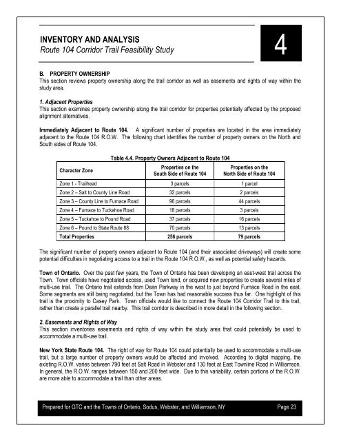
Character Zone<br />
Table 4.4. Property Owners Adjacent to <strong>Route</strong> <strong>104</strong><br />
Properties on the<br />
South Side of <strong>Route</strong> <strong>104</strong><br />
Properties on the<br />
North Side of <strong>Route</strong> <strong>104</strong><br />
Zone 1 - <strong>Trail</strong>head 3 parcels 1 parcel<br />
Zone 2 – Salt to County Line Road 32 parcels 2 parcels<br />
Zone 3 – County Line to Furnace Road 96 parcels 44 parcels<br />
Zone 4 – Furnace to Tuckahoe Road 18 parcels 3 parcels<br />
Zone 5 – Tuckahoe to Pound Road 37 parcels 16 parcels<br />
Zone 6 – Pound to State <strong>Route</strong> 88 70 parcels 13 parcels<br />
Total Properties 256 parcels 79 parcels<br />
The significant number of property owners adjacent to <strong>Route</strong> <strong>104</strong> (and their associated driveways) will create some<br />
potential difficulties in negotiating access to a trail in the <strong>Route</strong> <strong>104</strong> R.O.W., as well as potential safety hazards.<br />
Town of Ontario. Over the past few years, the Town of Ontario has been developing an east-west trail across the<br />
Town. Town officials have negotiated access, used Town land, or acquired new properties to create several miles of<br />
multi-use trail. The Ontario trail extends from Dean Parkway in the west to just beyond Furnace Road in the east.<br />
Some segments are still being negotiated, but the Town has had reasonable success thus far. One highlight of this<br />
trail is the proximity to Casey Park. Town officials would like to connect the <strong>Route</strong> <strong>104</strong> <strong>Corridor</strong> <strong>Trail</strong> to this trail,<br />
rather than create a parallel trail nearby. This trail corridor is described in more detail in the following section.<br />
2. Easements and Rights of Way<br />
This section inventories easements and rights of way within the study area that could potentially be used to<br />
accommodate a multi-use trail.<br />
New York State <strong>Route</strong> <strong>104</strong>. The right of way for <strong>Route</strong> <strong>104</strong> could potentially be used to accommodate a multi-use<br />
trail, but a large number of property owners would be affected and involved. According to digital mapping, the<br />
existing R.O.W. varies between 790 feet at Salt Road in Webster and 130 feet at East Townline Road in Williamson.<br />
In general, the R.O.W. ranges between 150 and 200 feet wide. Due to this variability, certain portions of the R.O.W.<br />
are more able to accommodate a trail than other areas.<br />
Prepared for GTC and the Towns of Ontario, Sodus, Webster, and Williamson, NY Page 23