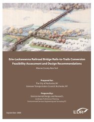
Route 104 Corridor Trail Feasibility Study - Genesee Transportation ...
Route 104 Corridor Trail Feasibility Study - Genesee Transportation ...
Route 104 Corridor Trail Feasibility Study - Genesee Transportation ...

You also want an ePaper? Increase the reach of your titles
YUMPU automatically turns print PDFs into web optimized ePapers that Google loves.
RECOMMENDATIONS<br />
6<br />
<strong>Route</strong> <strong>104</strong> <strong>Corridor</strong> <strong>Trail</strong> <strong>Feasibility</strong> <strong>Study</strong><br />
The following chapter includes information about the preferred trail alignment, design details, and project phasing.<br />
A. PREFERRED TRAIL ALIGNMENT<br />
The preferred alternative is the Railroad <strong>Trail</strong> as presented in the previous chapter. The Railroad <strong>Trail</strong> would be<br />
primarily located in the Ontario-Midland Railroad right-of-way. Unless otherwise specified, all road crossings will<br />
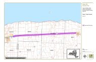
occur using an unsignalized, at-grade crosswalk. Please refer to Figure 17 for an illustration of the preferred trail<br />
alignment.<br />
1. Webster<br />
The trail would begin where the existing <strong>Route</strong> <strong>104</strong> trail ends, at the southwestern corner of the intersection of Salt<br />
Road and <strong>Route</strong> <strong>104</strong>. The trail would cross Salt Road using an at-grade crossing at an existing traffic light. Based<br />
on the information obtained during the gap study, crossing enhancements (e.g. pedestrian signal) would be needed.<br />
The trail would head north for approximately 700 feet along the eastern side of Salt Road, traveling under <strong>Route</strong> <strong>104</strong><br />
to the railroad right-of-way. The trail would cross <strong>Route</strong> <strong>104</strong> entrance ramps using enhanced crosswalks in existing<br />
crosswalk locations. The existing sidewalk would be expanded to 12 feet to accommodate the trail. At the railroad<br />
right-of-way, the trail would head due east along the northern side of the tracks for 1.25 miles until the trail reaches<br />
County Line Road and the Town of Ontario. At-grade road crossings of Basket Road and County Line Road, as well<br />
as a stream crossing of Four Mile Creek (West) will be necessary in this stretch of trail.<br />
Possible trailhead and parking location: The vicinity of Salt Road and the Railroad R.O.W. is recommended for a<br />
trailhead location.<br />
Cost Estimate: This section of trail is estimated to cost approximately $504,914. This preliminary figure includes<br />
expenses related to site preparation, 10‘ wide stone dust trail, boardwalks, sidewalk expansion, 1 stream crossing,<br />
drainage improvements, signage, site furniture, site restoration, and plantings. Also included are design and<br />
permitting fees, and an allowance for contingencies. See Appendix H for more detail.<br />
2. Ontario<br />
In the Town of Ontario, the trail begins at County Line Road and continues in the railroad corridor for approximately<br />
one-half mile to Dean Parkway, crossing Four Mile Creek (East) along the way. At Dean Parkway, the trail heads<br />
north for 700 feet. At the intersection with Timothy Lane, the trail turns in an easterly direction, running adjacent to<br />
Timothy Lane behind Harbec Plastics. The trail then turns slightly to the north and continues in an easterly direction<br />
to Lakeside Road, crossing Mill Creek along the way. From Lakeside Road, the trail trends slightly south while<br />
continuing in an easterly direction. Just to the west of Slocum Road, the trail crosses Dennison Creek (West).<br />
At Slocum Road, the trail turns and heads in a northeasterly direction for approximately 3,750 feet (0.7 miles) in the<br />
RG&E utility corridor. In the utility corridor, the trail crosses Dennison Creek (East) and a small pond. Approximately<br />
400 feet from Kenyon Road, the trail turns due east for 350 feet, and then turns southeast/east across the old Town<br />
landfill. The trail crosses Ontario Center Road and travels due east along the long narrow pond in Casey Park to the<br />
park entrance at Knickerbocker Road. The trail continues to travel due east after crossing Knickerbocker for<br />
approximately 1,100 feet, then turns due south for about 700 feet. At this point, the trail turns to the east again and<br />
goes across Town land to Furnace Road. The trail heads south along Furnace Road for approximately 700 feet.<br />
From Furnace Road, the trail turns and heads to the east for about 2,200 feet, crossing over the West and East<br />
branches of Bear Creek. From this point, the trail heads south to the railroad corridor again, and continues for 0.80<br />
miles to the town line at Fisher Road.<br />
Prepared for GTC and the Towns of Ontario, Sodus, Webster, and Williamson, NY Page 46