Route 104 Corridor Trail Feasibility Study - Genesee Transportation ...
Route 104 Corridor Trail Feasibility Study - Genesee Transportation ...
Route 104 Corridor Trail Feasibility Study - Genesee Transportation ...

Create successful ePaper yourself
Turn your PDF publications into a flip-book with our unique Google optimized e-Paper software.
RECOMMENDATIONS<br />
6<br />
<strong>Route</strong> <strong>104</strong> <strong>Corridor</strong> <strong>Trail</strong> <strong>Feasibility</strong> <strong>Study</strong><br />
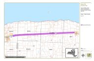
Williamson-Sodus town line, then one-third of a mile between the town line and Redman Road. From Redman Road,<br />
the trail travels another 0.80 miles to Centenary Road, and then another 0.90 miles to Pratt Road. From Pratt Road,<br />
the trail continues another 0.80 miles along the railroad corridor to the intersection of <strong>Route</strong> 88 and <strong>Route</strong> <strong>104</strong>, where<br />
the trail ends. The Village of Sodus is most safely accessed from the trail by continuing along the north side of <strong>Route</strong><br />
<strong>104</strong> to Maple Street, where there is a signalized intersection. From the Maple Street intersection, there are sidewalks<br />
for pedestrians and on-street bicycle access to the Village.<br />
Possible trailhead and parking location: A trailhead could potentially be located at the east end of the proposed trail.<br />
North of the <strong>Route</strong> <strong>104</strong> and <strong>Route</strong> 88 intersection is a used car dealership with an existing gravel road that could be<br />
used as an access point to the<br />
Cost Estimate: This section of trail is estimated to cost approximately $1,716,410. This preliminary figure includes<br />
expenses related to site preparation, 10‘ wide stone dust trail, boardwalks, drainage improvements, signage, site<br />
furniture, site restoration, and plantings. Also included are design and permitting fees, and an allowance for<br />
contingencies. See Appendix H for more detail.<br />
B. DESIGN DETAILS<br />
The <strong>Route</strong> <strong>104</strong> <strong>Corridor</strong> <strong>Trail</strong> study was primarily focused on assessing the feasibility of locating the trail in a<br />
particular location. However, preliminary design decisions were made to allow for estimating cost. The following<br />
design elements are recommended.<br />
1. <strong>Trail</strong> Design and Materials<br />
A 10‘ wide trail, composed of either stone dust or asphalt, is recommended. Other trail surfaces, such as recycled<br />
asphalt, are also possible. Recycled asphalt pavement is becoming an accepted alternative for trail design.<br />
Depending on availability, this material should be considered as an option during construction design.<br />
A drainage swale with native wet meadow plants would be located between the tracks and the trail to address<br />
drainage needs and to provide separation between trail users and the railroad tracks. An old field condition would be<br />
maintained in this area in order to keep open sight lines for safety and visibility. At a minimum, the trail would be<br />
located 50 feet away from the railroad tracks. Locating the trail in the railroad corridor maximizes natural resources,<br />
views, and rural scenic value. The trail is close enough to commercial areas to make it a useful transportation<br />
connector, but is far enough away from <strong>Route</strong> <strong>104</strong> to protect the safety of trail users, and to enhance the scenic<br />
quality of the trail. Figures 19 and 21 provide cross sections and illustrations that demonstrate typical trail<br />
construction and character.<br />
The <strong>Route</strong> <strong>104</strong> <strong>Corridor</strong> <strong>Trail</strong> will be supportive of the local economy and an enhancement to local businesses.<br />
Alternative 1, the Railroad <strong>Trail</strong> will be designed and constructed with enough flexibility that additional sidings could<br />
be constructed along the north side of the tracks. Site specific solutions for re-routing trail segments at new sidings<br />
can be designed in the future as necessary. The trail is secondary to economic development, and will adapt to the<br />
needs of new and expanding businesses.<br />
2. Boardwalks, Drainage Improvements and Stream Crossings<br />
Helical-pier boardwalks are recommended to traverse federal and state wetlands, streams, and poorly drained areas.<br />
The helical-pier boardwalk system requires no placement of fill for foundation systems, which minimizes impacts and<br />
streamlines environmental permitting. Surface and sub-surface hydrology are unimpeded by the boardwalk<br />
Prepared for GTC and the Towns of Ontario, Sodus, Webster, and Williamson, NY Page 48