Route 104 Corridor Trail Feasibility Study - Genesee Transportation ...
Route 104 Corridor Trail Feasibility Study - Genesee Transportation ...
Route 104 Corridor Trail Feasibility Study - Genesee Transportation ...

You also want an ePaper? Increase the reach of your titles
YUMPU automatically turns print PDFs into web optimized ePapers that Google loves.
ALTERNATIVES<br />
5<br />
<strong>Route</strong> <strong>104</strong> <strong>Corridor</strong> <strong>Trail</strong> <strong>Feasibility</strong> <strong>Study</strong><br />
C. ACCESS, OWNERSHIP AND CONTINUITY<br />
1. Access Points<br />
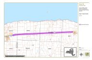
Access to the <strong>Route</strong> <strong>104</strong> <strong>Corridor</strong> <strong>Trail</strong> should not present a problem. All trail alignment alternatives intersect a<br />
number of roads, which provide ample opportunities for accessing the trail. The active transportation package is<br />
primarily on-street improvements and would have unrestricted access. All of the alternatives would be integrated<br />
with existing infrastructure and would have connections to the existing transportation network. Where the proposed<br />
trail alignment crosses a road, there would be open access for trail users.<br />
Access would be limited in order to keep unauthorized vehicles from entering the trail corridor, but managed in such<br />
a way that emergency vehicles could enter the trail when necessary. Small parking areas could be located at select<br />
locations where the trail crosses existing roads (see Chapter 6 and Figure 17 for proposed parking area locations).<br />
In addition, excess parking capacity in developed areas could serve as parking for trail users. Parking agreements<br />
would need to be negotiated in future trail development efforts.<br />
The <strong>Route</strong> <strong>104</strong> <strong>Corridor</strong> <strong>Trail</strong> proposed in this study will connect to the existing <strong>Route</strong> <strong>104</strong> <strong>Trail</strong> that ends at Salt<br />
Road in Webster. All of the alternative trail alignments, as well as the active transportation package, are designed to<br />
provide continuity with the existing trail. In addition, existing plans suggest that a future section of the <strong>Route</strong> <strong>104</strong> <strong>Trail</strong><br />
is planned from Sodus to Wolcott, linking the proposed trail with additional destinations.<br />
2. Private Property Use and Acquisition<br />
Land purchase is not recommended for either of the preferred alternatives. Therefore, a strategy for acquiring private<br />
property and/or public right-of-way is not needed to create a continuous ADA-compliant trail. In future design<br />
development phases, encroachments into the railroad right-of-way will need to be assessed. Several were noted<br />
during site analysis, but were not evaluated in detail.<br />
3. Complete Streets<br />
In addition to understanding the opportunities and constraints specific to the study area, we can look to the complete<br />
streets concept for solutions. According to the National Complete Streets Coalition (NCSC), complete streets are<br />
roadways designed and operated to enable safe, attractive, and comfortable access and travel for all users (NCSC,<br />
2008). Pedestrians, bicyclists, motorists and public transport users of all ages and abilities are able to safely and<br />
comfortably move along and across a complete street. Complete streets also create a sense of place, improve social<br />
interaction, and generally increase land values of adjacent property.<br />
Complete streets look different in different places. They must fit with their context and to the transportation modes<br />
expected (Laplante & McCann, 2008). Although no singular formula exists for a complete street, an effective one<br />
includes at least some of the following features (NCSC, 2009):<br />
- sidewalks - bus pullouts<br />
- bike lanes - special bus lanes<br />
- wide shoulders - raised crosswalks<br />
- plenty of crosswalks - audible pedestrian signals<br />
- refuge medians - sidewalk bump-outs (bulb-outs)<br />
These features make a street safer and more pleasant for pedestrians and vehicles. A Federal Highway<br />
Administration safety review found that designing a street for pedestrian travel by installing raised medians and<br />
Prepared for GTC and the Towns of Ontario, Sodus, Webster, and Williamson, NY Page 42