Route 104 Corridor Trail Feasibility Study - Genesee Transportation ...
Route 104 Corridor Trail Feasibility Study - Genesee Transportation ...
Route 104 Corridor Trail Feasibility Study - Genesee Transportation ...

Create successful ePaper yourself
Turn your PDF publications into a flip-book with our unique Google optimized e-Paper software.
INVENTORY AND ANALYSIS<br />
4<br />
<strong>Route</strong> <strong>104</strong> <strong>Corridor</strong> <strong>Trail</strong> <strong>Feasibility</strong> <strong>Study</strong><br />
5. Land Use<br />
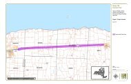
A snapshot of the existing land use can be illustrated by examining character zones and destinations along the <strong>Route</strong><br />
<strong>104</strong> <strong>Corridor</strong>. In addition, Figure 5 (Sheets 1 and 2) illustrates existing land use in and around the study area.<br />
Character Zones. The study area can be broken into six character zones, based primarily on land use, ecological<br />
character, and natural boundaries. The first character zone begins at the existing <strong>Route</strong> <strong>104</strong> trailhead, and ends at<br />
Salt Road in Webster. This zone is a focal point along the corridor, where the existing trail and the new trail will<br />
connect. The second character zone begins at Salt Road and ends at the County line between Wayne and Monroe<br />
Counties. The character of this zone is primarily mixed use commercial. The third character zone begins at the<br />
County line and ends at Furnace Road in the Town of Ontario. Zone 3 is primarily rural and undeveloped with<br />
heavier development and destinations located on the south side of <strong>Route</strong> <strong>104</strong>.<br />
The fourth character zone begins at Furnace Road in Ontario and ends at Tuckahoe Road in the Town of Williamson.<br />
This zone is primarily rural and undeveloped with a few significant nodes of development. The fifth character zone<br />
begins at Tuckahoe Road and ends at Pound Road, all within the Town of Williamson. The character of Zone 5 is a<br />
mix of commercial and residential uses. The sixth character zone begins at Pound Road in Williamson and ends at<br />
State <strong>Route</strong> 88 in the Town of Sodus. The character of this zone is rural farmland and mixed commercial. See<br />
Figure 7 for a map and Appendix A for photographs of existing conditions in the character zones.<br />
Destinations. Throughout the <strong>Route</strong> <strong>104</strong> <strong>Corridor</strong> are a number of destinations. Some destinations are a point of<br />
interest that might generate visits from people who live outside the local area, while others are more common<br />
services that would be visited primarily by local residents. All of these destinations can be considered pedestrian<br />
generators, or destinations that are frequented by pedestrians. In general, they are clustered near the downtown of<br />
each municipality, but are also found scattered along <strong>Route</strong> <strong>104</strong>. They include, but are not limited to:<br />
- Retail plazas and commercial areas in Ontario, Williamson and Sodus that include grocery stores,<br />
shopping, and financial institutions;<br />
- Schools in the Ontario, Sodus and Williamson school districts;<br />
- Libraries: Ontario Public Library, Sodus Free Library, and the Williamson Free Library;<br />
- Post offices in Union Hill, Ontario Center, Ontario, Williamson, and East Williamson;<br />
- Places of worship: More than 25 were identified in and near the corridor<br />
- Public parks: Irving R. Kent Park, Casey Park, Ontario Golf Course, B. Forman County Park, Williamson<br />
Town Park, and Beechwood State Park<br />
- Wegman‘s Passport Destinations: Bicentennial Park, Casey Park, Sodus Wallington <strong>Trail</strong>, and the<br />
Williamson Town Loop <strong>Trail</strong><br />
- Major places of employment: Xerox Corporation, Mott‘s North America, Ginna Nuclear Power Plant,<br />
Williamson and Sodus Airport, and Heluva Good Cheese<br />
- Significant travel destinations (in nearby vicinity): Historic Pultneyville, Sodus Point<br />
These land uses are prime examples of pedestrian generators. It is important that residents and visitors are able to<br />
safely walk (or bike) to and between some of these corridor destinations. Figure 6 illustrates the existing destinations<br />
located along the <strong>Route</strong> <strong>104</strong> <strong>Corridor</strong>. Strong pedestrian connections between destinations are what sustain a<br />
thriving pedestrian environment. <strong>Trail</strong> planning should strive to improve access for all types of trail users, whether the<br />
trail is being used for adjacent destinations within one character zone, or to provide a connection between different<br />
zones. <strong>Trail</strong> planning should also be context sensitive, responding to the different character zones and destinations,<br />
but following current best practices and guidelines from FHWA, AASHTO, and NYSDOT.<br />
Prepared for GTC and the Towns of Ontario, Sodus, Webster, and Williamson, NY Page 22