Route 104 Corridor Trail Feasibility Study - Genesee Transportation ...
Route 104 Corridor Trail Feasibility Study - Genesee Transportation ...
Route 104 Corridor Trail Feasibility Study - Genesee Transportation ...

Create successful ePaper yourself
Turn your PDF publications into a flip-book with our unique Google optimized e-Paper software.
EXECUTIVE SUMMARY<br />
1<br />
<strong>Route</strong> <strong>104</strong> <strong>Corridor</strong> <strong>Trail</strong> <strong>Feasibility</strong> <strong>Study</strong><br />
truck traffic, noise, and air quality issues related to the highway. This alternative would have significant access and<br />
safety concerns related to the number of property owners and associated driveways. Drainage is also a concern. In<br />
addition, most of the destinations are located on the south side of the highway. Providing access to these<br />
destinations from a trail on the north side of <strong>Route</strong> <strong>104</strong> might create unsafe crossings.<br />
A feasibility assessment matrix was developed to evaluate the different alternatives. The matrix utilizes the following<br />
criteria: environmental impacts, community connectivity, compatibility with other plans, public support, people to<br />
benefit from trail, ownership and access, safety, construction costs, and sustainability. Alternatives 1 and 2 both<br />
received a similar number of points (22 and 21 stars, respectively). The <strong>Route</strong> <strong>104</strong> R.O.W. <strong>Trail</strong>s (North and South)<br />
received a similar number of points to the No-Build Alternative (16 and 15 stars, respectively).<br />
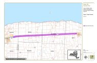
Preferred <strong>Trail</strong> Alignment. The preferred trail alignment is Alternative 1, the Railroad <strong>Trail</strong>. The trail would begin<br />
where the existing <strong>Route</strong> <strong>104</strong> trail ends, at the southwestern corner of the intersection of Salt Road and <strong>Route</strong> <strong>104</strong>.<br />
The trail would cross Salt Road and head north along the eastern side of Salt Road, traveling under <strong>Route</strong> <strong>104</strong> to the<br />
railroad right-of-way. At the railroad right-of-way, the trail would head due east along the northern side of the tracks<br />
for 1.25 miles until the trail reaches County Line Road and the Town of Ontario.<br />
In the Town of Ontario, the trail continues in the railroad corridor for approximately one-half mile to Dean Parkway,<br />
where the trail heads north for 700 feet. At the intersection with Timothy Lane, the trail turns in an easterly direction,<br />
running adjacent to Timothy Lane. The trail then turns slightly to the north and continues in an easterly direction to<br />
Lakeside Road. From here, the trail trends slightly south while continuing in an easterly direction. At Slocum Road,<br />
the trail turns and heads in a northeasterly direction for approximately 0.7 miles in the RG&E utility corridor.<br />
Approximately 400 feet from Kenyon Road, the trail turns due east for 350 feet, and then turns southeast/east across<br />
the old Town landfill. The trail crosses Ontario Center Road and travels due east along the long narrow pond in<br />
Casey Park to the park entrance at Knickerbocker Road. The trail continues to travel due east, after crossing<br />
Knickerbocker, for approximately 1,100 feet, then turns due south for about 700 feet. At this point, the trail turns to<br />
the east again and goes across Town land to Furnace Road. The trail heads south along Furnace Road for<br />
approximately 700 feet. From Furnace Road, the trail turns and heads to the east for about 2,200 feet. From this<br />
point, the trail heads south to the railroad corridor again, and continues for 0.80 miles to the town line at Fisher Road.<br />
The 5.5-mile Williamson section of trail begins at Fisher Road and continues in the railroad corridor to Tuckahoe<br />
Road. A slight jog to the north or south will be necessary for 0.75 miles between Tuckahoe and Lake Avenue. At<br />
Lake Avenue, the trail jogs back to the north side of the railroad tracks and continues on to East Townline Road.<br />
(However, between Lake Avenue and East Townline Road, there are potential choke points that will need to be<br />
addressed in later design development phases.) From East Townline Road, the trail then travels 3.25 miles to the<br />
intersection of <strong>Route</strong> <strong>104</strong> and <strong>Route</strong> 88. This entire section is in the railroad corridor. The estimated cost for the<br />
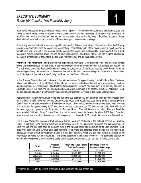
entire trail development project, including design, construction and permitting can be seen in the following chart.<br />
Town<br />
Proposed Basic <strong>Trail</strong> Cost – Stone Enhanced <strong>Trail</strong> Cost –<br />
<strong>Trail</strong> Length Dust, No Gateways Asphalt and Gateways<br />
Webster 1.4 miles $504,914 $555,876<br />
Ontario 6.8 miles $2,493,425 $2,629,421<br />
Williamson 5.5 miles $2,560,907 $2,710,499<br />
Sodus 3.3 miles $1,716410 $1,826,592<br />
Total 17.0 miles $7,357,767 $7,804,499<br />
Prepared for GTC and the Towns of Ontario, Sodus, Webster, and Williamson, NY Page 7